Browse Listings in America
![Partie occidentale de l'Isle de la Guadeloupe appellée la Basse Terre. / Partie Orientale de l'Isle de la Guadeloupe.. [2 maps]](/uploads/cache/17051-250x250.jpg)
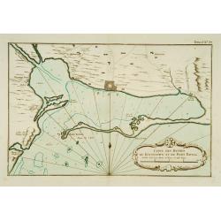
Partie occidentale de l'Isle de la Guadeloupe appellée la Basse Terre. / Partie Orientale de l'Isle de la Guadeloupe.. [2 maps]
A set of 2 maps showing the northern and southern islands of Guadeloupe.The only issue of this version of Bellin's maps, slightly larger than the common version. Depths s...
Date: Paris 1764
Selling price: ????
Please login to see price!
Sold
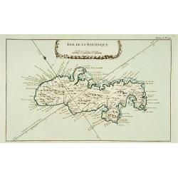
Isle de la Martinique.
This chart shows the island of Martinique,.The only issue of this version of Bellin's map, slightly larger than the common version.From Bellin's Petit atlas maritime.Tome...
Date: Paris 1764
Selling price: ????
Please login to see price!
Sold
![Partie Septentrionale de la Martinique. / Partie Meridionale de la Martinique. [set of 2 maps]](/uploads/cache/17054-250x250.jpg)
Partie Septentrionale de la Martinique. / Partie Meridionale de la Martinique. [set of 2 maps]
A set of two maps depicting the island Martinique.Engraved by Croisey. The only issue of this version of Bellin's map, slightly larger than the common version. Depths sho...
Date: Paris 1764
Selling price: ????
Please login to see price!
Sold
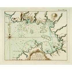
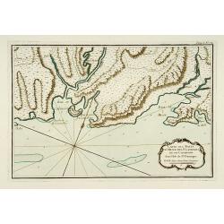
Partie du Cul de Sac Royal de la Martinique.
This chart shows the territories of the bay around Fort Royal on the island of Martinique.The only issue of this version of Bellin's map, slightly larger than the common ...
Date: Paris 1764
Selling price: ????
Please login to see price!
Sold
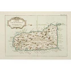
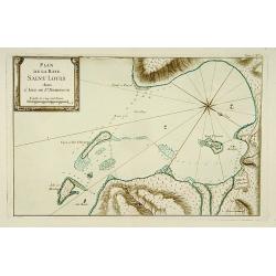
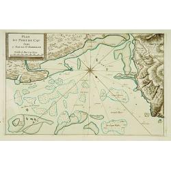
Carte de l'Isle de Sainte Lucie.
This chart shows the island Saint Lucie.The only issue of this version of Bellin's map, slightly larger than the common version.From Bellin's Petit atlas maritime.Tome I ...
Date: Paris 1764
Selling price: ????
Please login to see price!
Sold
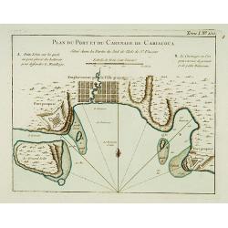
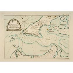
Plan du Port et du Carenage de Cariacoua.
A map of the proposed city and harbour of Carenage de Cariacoua, on the island of St. Vincent.The only issue of this version of Bellin's map, slightly larger than the com...
Date: Paris 1764
Selling price: ????
Please login to see price!
Sold
Plan de la Baye Saint Louis dans l'Isle de Saint Domingue.
This chart shows the Bay of Saint Louis on the island Saint-Domingue.The only issue of this version of Bellin's map, slightly larger than the common version. Depths shown...
Date: Paris 1764
Selling price: ????
Please login to see price!
Sold
Carte des Bayes Du Mesle des Flamands et de Cavaillon dans l'Isle de St Domingue.
This chart shows the south coast of St Domingo, with the bay area's of Bayes du Mesle des Flamands and Cavaillon.The only issue of this version of Bellin's map, slightly ...
Date: Paris 1764
Selling price: ????
Please login to see price!
Sold
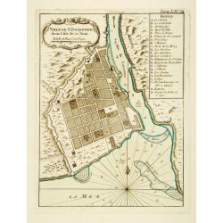
Port et Ville de Porto-Rico dans l'Isle de ce nom.
This chart shows the territories of the harbour and town of "Porto Rico" on St. Jean Island, St. John. The only issue of this version of Bellin's map, slightly ...
Date: Paris 1764
Selling price: ????
Please login to see price!
Sold
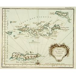
Carte des isles des vierges.
This chart shows the Virgin Islands with island Saint Croix.The only issue of this version of Bellin's map, slightly larger than the common version.From Bellin's Petit at...
Date: Paris 1764
Selling price: ????
Please login to see price!
Sold
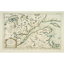
Partie du Fleuve de Saint -Laurent avec le Bassin de Québec et l'Isle d'Orléans.
This chart shows the island of Orleans in the river Saint Laurent .The only issue of this version of Bellin's map, slightly larger than the common version. Depths shown b...
Date: Paris 1764
Selling price: ????
Please login to see price!
Sold
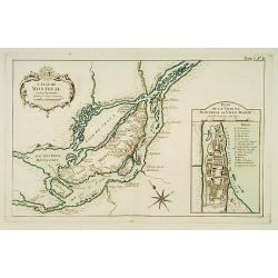
L'Isle de Montréal et ses Environs.
This chart shows the territories of the island Montreal, with an inset plan of the town with a lettered key.The only issue of this version of Bellin's map, slightly large...
Date: Paris 1764
Selling price: ????
Please login to see price!
Sold
![[Detroit] La Rivière du Détroit Depuis le lac Sainte Claire jusqu'au Lac Erié.](/uploads/cache/17065-250x250.jpg)
[Detroit] La Rivière du Détroit Depuis le lac Sainte Claire jusqu'au Lac Erié.
This is the first separately printed map of Detroit, showing the village, fort, anchorages, islands and navigational hazards, with an inset of the fort with five lettered...
Date: Paris 1764
Selling price: ????
Please login to see price!
Sold
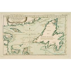
Le Golphe de Saint-Laurent et l'Isle de Terre-Neuve.
This chart shows the territories the Saint Laurent and the island of Newfoundland.The only issue of this version of Bellin's map, slightly larger than the common version....
Date: Paris 1764
Selling price: ????
Please login to see price!
Sold
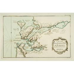
Carte des Bayes, Rades et Port de Plaisance dans l'Isle de Terre-Neuve.
This chart shows the territories of the bay and harbour of Plaisance on New Found land.The only issue of this version of Bellin's map, slightly larger than the common ver...
Date: Paris 1764
Selling price: ????
Please login to see price!
Sold
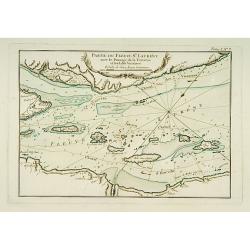
Partie du Fleuve de Saint Laurent avec le Passage de la Traverse et des Isles Voisines.
Striking chart shows islands in the St. Lawrence River in the channels east/northeast of Isle D'Orleans. Locates the Iberville Channel & the current ship channel used...
Date: Paris 1764
Selling price: ????
Please login to see price!
Sold
Cours du Fleuve de Saint Laurent depuis la Mer jusqu'à Québec.
Handsome chart shows the lands on both sides of the St. Lawrence River from the Gulf to Quebec. Includes the Gaspe Peninsula, Chaleurs Bay, Isle St. Jean (Prince Edward I...
Date: Paris 1764
Selling price: ????
Please login to see price!
Sold
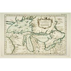
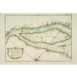
Carte des Cinq Grands Lacs du Canada.
This map shows the territories of all the 5 great lakes. The map shows Indian land, forts, missions, rivers and lakes, plus some trails and portages.The only issue of thi...
Date: Paris 1764
Selling price: ????
Please login to see price!
Sold
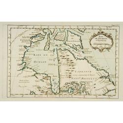
Baye de Hudson et Pays Voisins.
This chart shows the territories of Hudson Bay.The only issue of this version of Bellin's map, slightly larger than the common version. Depths shown by soundings.From Bel...
Date: Paris 1764
Selling price: ????
Please login to see price!
Sold
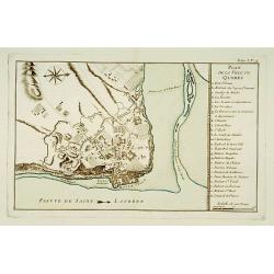
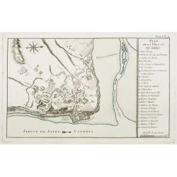
Plan de la Ville de Québec.
A detailed plan the territories of city of Québec. With a lettered key, indicating the principal places in town.The only issue of this version of Bellin's map, slightly ...
Date: Paris 1764
Selling price: ????
Please login to see price!
Sold
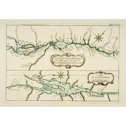
Partie du Fleuve St. Laurent depuis Québec jusqu'au Lac St. François. / Carte du Lac Champlain.
Two charts on one sheet. The upper chart showing the river S.Laurence from Quebec. The lower chart is a detailed depiction of Lake Champlain.The only issue of this versio...
Date: Paris 1764
Selling price: ????
Please login to see price!
Sold
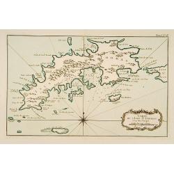
Carte de l'Isle St-Thomas l'Une des Vierges.
This chart shows the island St-Thomas.The only issue of this version of Bellin's map, slightly larger than the common version. Depths shown by soundings.From Bellin's Pet...
Date: Paris 1764
Selling price: ????
Please login to see price!
Sold
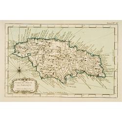
Carte de l'Isle de la Jamaïque.
This chart shows the island of Jamaica.The only issue of this version of Bellin's map, slightly larger than the common version.From Bellin's Petit atlas maritime.Tome I N...
Date: Paris 1764
Selling price: ????
Please login to see price!
Sold
Carte des Havres de Kingstown et de Port Royal.
This chart shows the harbour of Kingston and the fortress of Port Royal.The only issue of this version of Bellin's map, slightly larger than the common version. Depths sh...
Date: Paris 1764
Selling price: ????
Please login to see price!
Sold
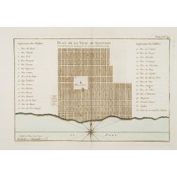
Plan de la Ville de Kingston Suivant le projet donné par le Colonel Christian Lilly.
Plan of the city of Kingston on Jamaica. With a numbered key (1-32) referring to the names of the principal streets.The only issue of this version of Bellin's map, slight...
Date: Paris 1764
Selling price: ????
Please login to see price!
Sold
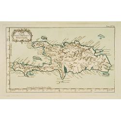
Isle de St Domingue.
This chart shows the island St Domingue.The only issue of this version of Bellin's map, slightly larger than the common version. Depths shown by soundings.From Bellin's P...
Date: Paris 1764
Selling price: ????
Please login to see price!
Sold
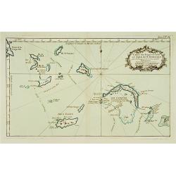
Carte des Isles situées au Nord de St Domingue Avec les Passages pour le retour appellés Débouquemens.
This chart shows the territories of the Caicos Islands and Acklins islands, north of St. Domingue.The only issue of this version of Bellin's map, slightly larger than the...
Date: Paris 1764
Selling price: ????
Please login to see price!
Sold
Plan Du Port du Cap dans l'Isle de St. Domingue.
This chart shows the harbour of Cap on the island St-Domingue.The only issue of this version of Bellin's map, slightly larger than the common version. Depths shown by sou...
Date: Paris 1764
Selling price: ????
Please login to see price!
Sold
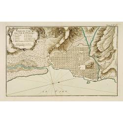
Ville du Cap dans l'Isle de St Domingue.
This chart shows the territories of city of Cap in Isle of St Domingue. Engraved by Croisey.The only issue of this version of Bellin's map, slightly larger than the commo...
Date: Paris 1764
Selling price: ????
Please login to see price!
Sold
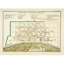
Plan de la Nouvelle Orléans.
A map of New Orleans.The only issue of this version of Bellin\'s map, slightly larger than the common version. Depths shown by soundings.From Bellin\'s Petit atlas mariti...
Date: Paris 1764
Selling price: ????
Please login to see price!
Sold
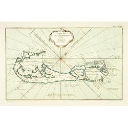
Carte des Isles Bermudes ou de Sommer.
This chart shows the island of Bermuda.The only issue of this version of Bellin's map, slightly larger than the common version. Depths shown by soundings.From Bellin's Pe...
Date: Paris 1764
Selling price: ????
Please login to see price!
Sold
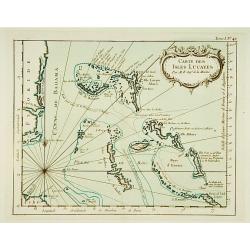
Carte des Isles Lucayes.
This chart shows the territories of the Bahamas, and the East coast of southern Florida. The only issue of this version of Bellin's map, slightly larger than the common v...
Date: Paris 1764
Selling price: ????
Please login to see price!
Sold
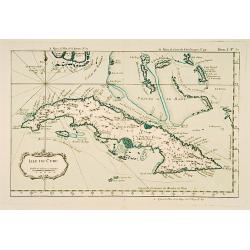
Isle de Cube.
This chart shows the island of Cuba.The only issue of this version of Bellin's map, slightly larger than the common version. Depths shown by soundings.From Bellin's Petit...
Date: Paris 1764
Selling price: ????
Please login to see price!
Sold
Embouchures du Fleuve St Louis ou Mississipi.
Shows the Mississippi River where it empties into the Gulf of Mexico.The only issue of this version of Bellin's map, slightly larger than the common version. Depths shown...
Date: Paris 1764
Selling price: ????
Please login to see price!
Sold
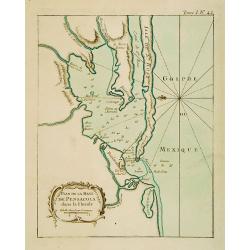
Plan de la Baye de Pensacola dans la Floride.
This chart shows the territories of the inlet of Pensacola in Florida The only issue of this version of Bellin's map, slightly larger than the common version. Depths show...
Date: Paris 1764
Selling price: ????
Please login to see price!
Sold
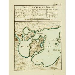
Plan de la Ville de Boston.
One of the earliest obtainable town plans of Boston, from Bellin's Petit Atlas Maritime. Shows Boston 13 years prior to the American Revolution.The only issue of this ver...
Date: Paris 1764
Selling price: ????
Please login to see price!
Sold
![Carte de la Baye de Baston. [Boston]](/uploads/cache/17094-250x250.jpg)
Carte de la Baye de Baston. [Boston]
A nice chart of the bay and city plan of Boston. Islands and navigation hazards are all clearly marked. Fleur-de-lys and rhumb lines.The only issue of this version of Bel...
Date: Paris 1764
Selling price: ????
Please login to see price!
Sold
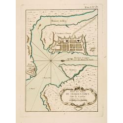
Port et Ville de Charles-Town dans la Caroline.
This chart shows a block plan of Charleston and the entrance to the harbour where the Cooper and Ashley Rivers meet. Fort Johnson is sketched on the shore at the entrance...
Date: Paris 1764
Selling price: ????
Please login to see price!
Sold
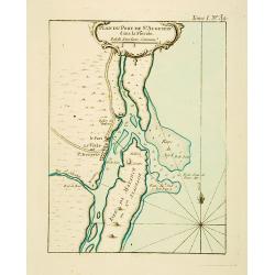
Plan du Port de St Augustin dans la Floride.
This chart shows a plan of the Port of St. Augustine in Florida.The only issue of this version of Bellin's map, slightly larger than the common version. Depths shown by s...
Date: Paris 1764
Selling price: ????
Please login to see price!
Sold
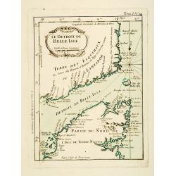
Le Détroit de Belle-Isle.
This chart shows the territories of Strait of Belle-Isle with parts of Labrador and northern part of Newfound land.The only issue of this version of Bellin's map, slightl...
Date: Paris 1764
Selling price: ????
Please login to see price!
Sold
Ville de St. Domingue dans l'Isle de ce Nom.
This chart shows a plan of the city of Santo Domingo on the Dominican Republic. With a lettered key to the principal places in town.The only issue of this version of Bell...
Date: Paris 1764
Selling price: ????
Please login to see price!
Sold
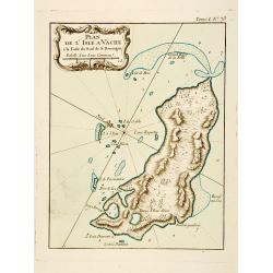
Plan de l'Isle A Vache a la Coste Sud de S. Domingue.
This chart shows the little island l'Isle à Vache on present day Haiti.The only issue of this version of Bellin's map, slightly larger than the common version. Depths sh...
Date: Paris 1764
Selling price: ????
Please login to see price!
Sold
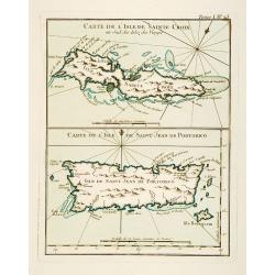
Carte de l'Isle de Sainte Croix au Sud des Isles des Vierges. / Carte de l'Isle de Saint Jean de Portorico.
This chart shows the islands of Sainte Croix and Isle Saint Jean de Porto Rico The only issue of this version of Bellin's map, slightly larger than the common version. De...
Date: Paris 1764
Selling price: ????
Please login to see price!
Sold
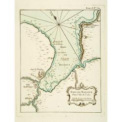
Baye de Matance dans l'Isle de Cube.
This chart shows the Bay of Matance on the island of Cuba.The only issue of this version of Bellin's map, slightly larger than the common version. Depths shown by soundin...
Date: Paris 1764
Selling price: ????
Please login to see price!
Sold
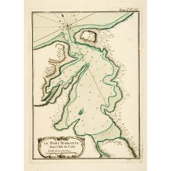
Le Port Marianne dans l'Isle de Cube.
This chart shows the bay of the harbour of Marianne on the island of Cuba. The only issue of this version of Bellin's map, slightly larger than the common version. Depths...
Date: Paris 1764
Selling price: ????
Please login to see price!
Sold
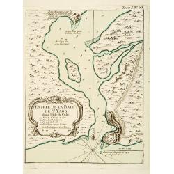
Entrée de la Baye de St Yago dans l'Isle de Cube.
This chart shows the bay of St Yago on the island of Cuba.The only issue of this version of Bellin's map, slightly larger than the common version. Depths shown by soundin...
Date: Paris 1764
Selling price: ????
Please login to see price!
Sold
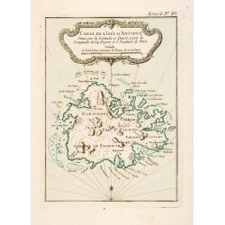
Carte de l'Isle d'Antigue Située par la Latitude 17 Degrés et par la Longitude de 64 Degrés à l'Occident de Paris
This chart shows the island of Antigua.The only issue of this version of Bellin's map, slightly larger than the common version. Depths shown by soundings.From Bellin's Pe...
Date: Paris 1764
Selling price: ????
Please login to see price!
Sold
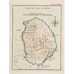
Carte de l'Isle de Nieves.
This chart shows the island of Nieves. The only issue of this version of Bellin's map, slightly larger than the common version. Depths shown by soundings.From Bellin's Pe...
Date: Paris 1764
Selling price: ????
Please login to see price!
Sold
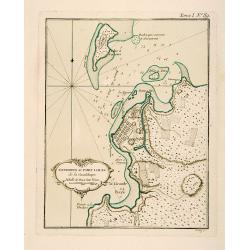
Environs du Fort Louis de la Guadeloupe.
This chart shows the territories around Fort Louis on the island of Guadeloupe The only issue of this version of Bellin's map, slightly larger than the common version. De...
Date: Paris 1764
Selling price: ????
Please login to see price!
Sold
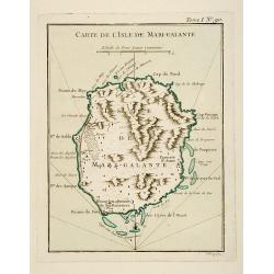
Carte de l'Isle de Marie-Galante.
This chart shows the territories of Isle Marie-Galante The only issue of this version of Bellin's map, slightly larger than the common version. Depths shown by soundings....
Date: Paris 1764
Selling price: ????
Please login to see price!
Sold
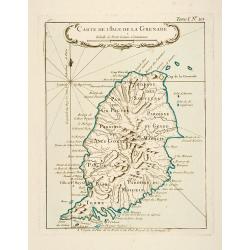
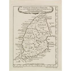
Carte de l'Isle de la Grenade.
This chart shows the island Granada.The only issue of this version of Bellin's map, slightly larger than the common version. Depths shown by soundings.From Bellin's Petit...
Date: Paris 1764
Selling price: ????
Please login to see price!
Sold
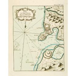
Port et Fort Royal de la Grenade.
This chart shows the territories of the harbour and fortress Royal on the island of Grenada.The only issue of this version of Bellin's map, slightly larger than the commo...
Date: Paris 1764
Selling price: ????
Please login to see price!
Sold
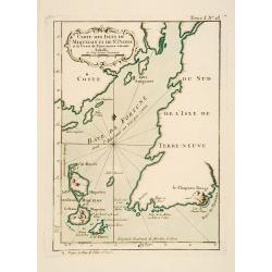
Carte des Isles de Miquelon et de St. Pierre et la Coste de Terre Neuve voisine.
This chart shows the territories of the Miquelon islands and St Pierre.The only issue of this version of Bellin's map, slightly larger than the common version. Depths sho...
Date: Paris 1764
Selling price: ????
Please login to see price!
Sold
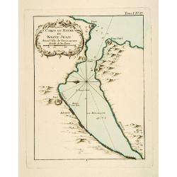
Carte du Havre de Saint-Jean dans l'Isle de Terre-neuve.
This chart shows the territories of the harbour of Saint-Jean on New Found land.The only issue of this version of Bellin's map, slightly larger than the common version. D...
Date: Paris 1764
Selling price: ????
Please login to see price!
Sold
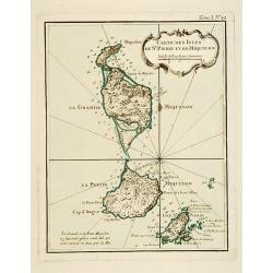
Carte Des Isles De St. Pierre et de Miquelon.
This chart shows the territories of the islands of St. Pierre and Miquelon.The only issue of this version of Bellin's map, slightly larger than the common version. Depths...
Date: Paris 1764
Selling price: ????
Please login to see price!
Sold
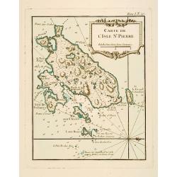
Carte de l'Isle de St. Pierre.
This chart shows the territories of the island of St. Pierre in New Found land.The only issue of this version of Bellin's map, slightly larger than the common version. De...
Date: Paris 1764
Selling price: ????
Please login to see price!
Sold
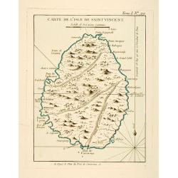
Carte de l'Isle de Saint Vincent.
This chart shows the island of St. Vincent The only issue of this version of Bellin's map, slightly larger than the common version. Depths shown by soundings.From Bellin'...
Date: Paris 1764
Selling price: ????
Please login to see price!
Sold
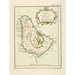
Carte de l'Isle de la Barbade.
This chart shows the island Barbados.The only issue of this version of Bellin's map, slightly larger than the common version. Depths shown by soundings.From Bellin's Peti...
Date: Paris 1764
Selling price: ????
Please login to see price!
Sold
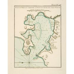
Plan du Port du Carenage ou Petit Cul de Sac de l'Isle Se Lucie.
This chart shows the territories of the harbour of Carenage or Petit Cul de Sac on the island of Sant Lucie.The only issue of this version of Bellin's map, slightly large...
Date: Paris 1764
Selling price: ????
Please login to see price!
Sold
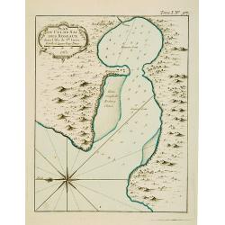
Plan du Cul de Sac des Roseaux dans l'Isle de Ste. Lucie.
This chart shows the territories of Cul de Sac des Roseaux on the island of Saint Lucie. The only issue of this version of Bellin's map, slightly larger than the common v...
Date: Paris 1764
Selling price: ????
Please login to see price!
Sold
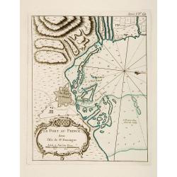
Plan du Port-au-Prince dans l'Isle de St Domingue.
This chart shows the territories of the town of Port-au-Prince on the island St Domingue.The only issue of this version of Bellin's map, slightly larger than the common v...
Date: Paris 1764
Selling price: ????
Please login to see price!
Sold
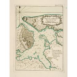
Port de la Havane dans l'Isle de Cube .
This chart shows the territories of the town and harbour of Havana on the island of Cuba.The only issue of this version of Bellin's map, slightly larger than the common v...
Date: Paris 1764
Selling price: ????
Please login to see price!
Sold
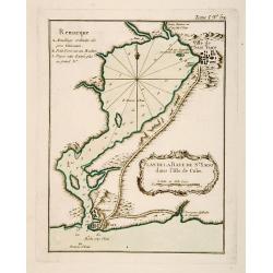
Plan de la Baye de St. Yago dans l'Isle de Cube.
This chart shows the territories and Bay of St. Yago on the island of Cuba.The only issue of this version of Bellin's map, slightly larger than the common version. Depths...
Date: Paris 1764
Selling price: ????
Please login to see price!
Sold
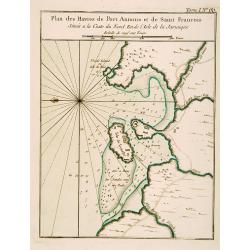
Plan des Havres de Port Antonio et de Saint François Situés a la Coste du Nord Est de la Jamaïque.
This chart shows the territories and harbour of Port Antonio on the island of Jamaica. The only issue of this version of Bellin's map, slightly larger than the common ver...
Date: Paris 1764
Selling price: ????
Please login to see price!
Sold
![Suite des Isles Antilles 2.Partie. Together with 2.Partie [2 maps].](/uploads/cache/17123-250x250.jpg)
Suite des Isles Antilles 2.Partie. Together with 2.Partie [2 maps].
These set of 2 chart are showing the Antilles Islands of Guadeloupe, Dominique, Martinique, Grenada, St.Vincent and St. Lucie.The only issue of this version of Bellin's m...
Date: Paris 1764
Selling price: ????
Please login to see price!
Sold
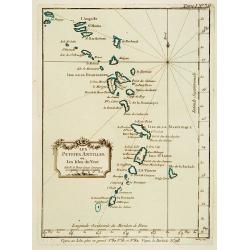
Les Petites Antilles ou Les Isles du Vent.
This chart shows the territories of the smaller Antilles or Windward islands.The only issue of this version of Bellin's map, slightly larger than the common version. Dept...
Date: Paris 1764
Selling price: ????
Please login to see price!
Sold
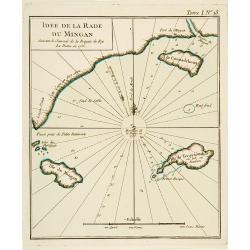
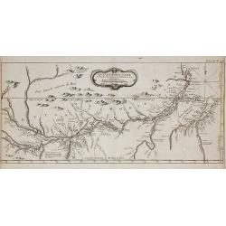
Idée de La Rade du Mingan. Suivant le Journal de la Fregate du Roy La Diane en 1755.
An engraved chart showing part of the mainland and three islands on New Found land.The only issue of this version of Bellin's map, slightly larger than the common version...
Date: Paris 1764
Selling price: ????
Please login to see price!
Sold
Carte d'une Grande Partie de la Colonie de Surinam.
Nice map of the Dutch colony of Suriname with excellent detail of the Suriname and Commewijne river systems, noting the boundaries of all the plantations laid along their...
Date: Paris, ca. 1764
Selling price: ????
Please login to see price!
Sold in 2008
Carte de l'Isle de la Grenade, Pour servir?
Detailed map of the island Grenada by Jacques Nicolas Bellin (1703-1772), one of the most important and proficient French cartographers of the mid-eighteenth century.He w...
Date: Paris 1764
Selling price: ????
Please login to see price!
Sold
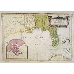
Carte Reduite Des Costes De La Louisiane Et De La Floride..
A well engraved and highly detailed chart of Florida, the Gulf Coast and the Mississippi Valley. This is one of the best examples of Florida as an Archipelago.The region ...
Date: Paris 1764
Selling price: ????
Please login to see price!
Sold in 2013
Guyane Portugaise et Partie du Cours de la Riviere des Amazones.
A good engraved map of the Amazon.
Date: Paris, 1764
Selling price: ????
Please login to see price!
Sold in 2010
Plan de la Ville de Québec.
A detailed plan the territories of city of Québec. With a lettered key, indicating the principal places in town.The only issue of this version of Bellin's map, slightly ...
Date: Paris, 1764
Selling price: ????
Please login to see price!
Sold in 2021
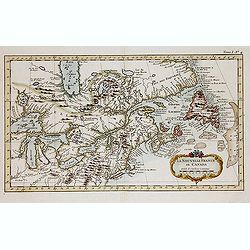
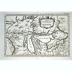
La Nouvelle France où Canada.
This chart shows the territories of New-France and Canada the day before the signature of the treaty of Paris.The only issue of this version of Bellin's map, slightly lar...
Date: Paris, 1764
Selling price: ????
Please login to see price!
Sold in 2013
Carte des cinq Grands Lacs du Canada.
A good engraved map of the Great Lakes area, showing the imaginary islands of Philippeaux and Pontchartrain in Lake Superior. From l'Histoire générale des voyages .Bell...
Date: Paris, 1764
Selling price: ????
Please login to see price!
Sold in 2013
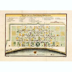
Plan De La Nouvelle-Orleans Sur les Manuscrits du Depot des Cartes De la Marine . . .
An important transitional and very detailed early map of New Orleans, copied after the original manuscript plan of the city drafted by Le Blond de la Tour in 1722. - the ...
Date: Paris, 1764
Selling price: ????
Please login to see price!
Sold in 2014
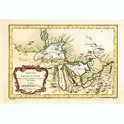
Carte Des Lacs Du Canada Pour sevir a l'Histoire Generale des Voyages.
Showing the all the Great Lakes in the traditional Bellin configuration. Jacques Nicolas Bellin (1703-1772) was one of the most important and proficient French cartograph...
Date: Paris, 1764
Selling price: ????
Please login to see price!
Sold in 2014
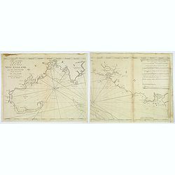
A New and Correct Chart of the Sea Coast of New England from Cape Codd to Casco Bay. . .
Two sheets, each 480 x 585 mm., not joined. This is one of the rarer of the large sea charts of New England to appear in Mount & Page's 'English Pilot Fourth Book'.Th...
Date: London, 1764
Selling price: ????
Please login to see price!
Sold in 2017
Carte Reduite des Costes de la Louisiane et de la Floride.
A very rare and large original engraved sea chart by Bellin from 1764. Details include Florida, the Gulf Coast and the Mississippi Valley. This is one of the best example...
Date: Paris, 1764
Selling price: ????
Please login to see price!
Sold in 2018
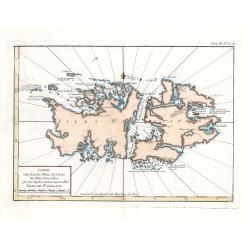
Carte Des Isles Malouines ou Isles Nouvelles - Isles de Falkland
This elegant sea chart of the Falkland Islands by Jacques Nicolas Bellin is from his ‘Le Petit Atlas Maritime…’, which covered the world to the extent it was known ...
Date: Paris, 1764
Selling price: ????
Please login to see price!
Sold in 2023
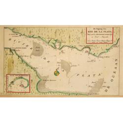
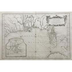
De Ingang van Rio de la Plata, Waar aan de Stad Buenos Ayres ligt, in Zuid-Amerika.
A map showing the Rio de la Plata estuary with the town of Buenos Aires. With an inset depicting the Bay of Maldonado.
Date: Amsterdam, 1765
Selling price: ????
Please login to see price!
Sold