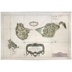
Browse Listings in America
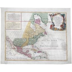
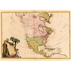
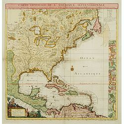
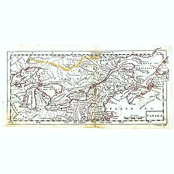
America Septentrionalis concinnata...
A copperplate colored map of the north east America, that shows California as an island, after the foundation map by de L'Isle published in 1700, which was the first map ...
Date: Augsburg, 1760
Selling price: ????
Please login to see price!
Sold in 2017
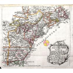
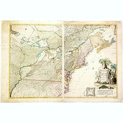
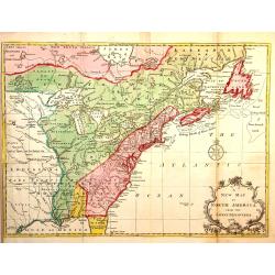
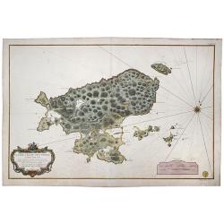
America septentrionalis oder Mitternachtiger theil von America bestehend in Neu Brittania, Canada, Neu Engeland, Neu Schotland, Neu Jorck, Pensylvania, Carolina, Florida, Georgien. . .
A rare German map of the East Coast of North America. Shows the British Colonies at the end of the Franco-Indian War, and extends from Newfoundland until Florida, and wes...
Date: Augsburg, ca 1760
Selling price: ????
Please login to see price!
Sold in 2018
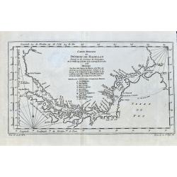
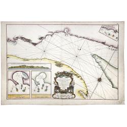
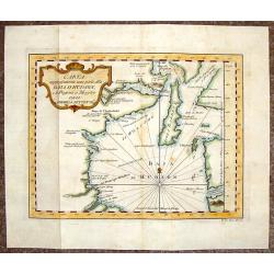
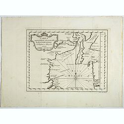
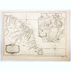
Carte Reduite Du Détroit de Magellan. . .
Bellin's important and interesting map of the Straits of Magellan and parts of Tierra del Fuego, dated 1753. It extends from Cap des Vierges to Cap de la Victoire, and in...
Date: Paris, ca. 1760
Selling price: ????
Please login to see price!
Sold in 2021

Vue perspective de la Ville de St. Francois de campeche dans l'Amerique Septentrionalle.
An optica print with a view on the city of Campeche, Yucatan, Mexico, several ships in the foreground. Published by Jean-François Daumont, Paris, ca. 1760.
Date: Paris, ca. 1760
Selling price: ????
Please login to see price!
Sold in 2020
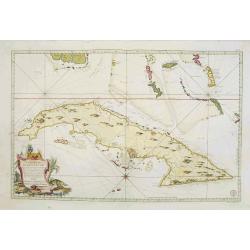
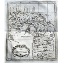
![Carte Reduite de L'Isle de Cube [Cuba]. Dressee au Depoit des Cartes et Plans de la Marine. . .](/uploads/cache/84494-250x250.jpg)
Carte Reduite de L'Isle de Cube [Cuba]. Dressee au Depoit des Cartes et Plans de la Marine. . .
A well engraved and highly detailed nautical chart of Cuba. It shows soundings, anchorage's, channels, shoals, navigational sightings. Also shows small parts of Florida a...
Date: Paris, 1760
Selling price: ????
Please login to see price!
Sold in 2021
![[A lot of 5 map of Guyana.] Land-kaart van Cayenne.](/uploads/cache/20452-250x250.jpg)
[A lot of 5 map of Guyana.] Land-kaart van Cayenne.
An attractive map of the island and settlement of Cayenne, with an inset picturing a plan of the town and fort of Cayenne. Izaak Tirion (d. 1769) Amsterdam publisher. H...
Date: Amsterdam, c. 1760
Selling price: ????
Please login to see price!
Sold in 2022
![[Lot of 10 maps /views of the Caribbeans], Terre Ferme, Isles Antilles et N.lle Espagne.](/uploads/cache/18346-(1)-250x250.jpg)
[Lot of 10 maps /views of the Caribbeans], Terre Ferme, Isles Antilles et N.lle Espagne.
Louis Brion de la Tour (1756-1823), ' Atlas Géneral, Civil et Ecclésiastique', 1766, ' Atlas Général', 1790-98. Louis Charles Desnos (fl.1750-70), Le Rouge's 'Atlas...
Date: Paris, c. 1760
Selling price: ????
Please login to see price!
Sold in 2022
Partie du Cours du Fleuve de Saint Laurent... Carte du Cours du Fleuve de Saint Laurent depuis Quebec jus
Two charts horizontally oriented with tremendous detail of the rivers and shoreline. Decorated with three rococo-style cartouches and rhumb lines.Good margins sheet size ...
Date: Paris, 1761
Selling price: ????
Please login to see price!
Sold in 2014
Theatrum belli in America Septentrionali. II. foliis comprehensum jussu Acad. Reg. Scient. et Eleg. Litt. exhibet I. C. Rhode Ac: Geogr.
Separately issued map of the northeastern part of the United States and Eastern Canada from the Mississippi Valley to the Atlantic Seaboard, published during the French a...
Date: Berlin, 1761
Selling price: ????
Please login to see price!
Sold in 2018
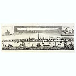
The East Prospect of the City of Philadelphia, in the Province of Pennsylvania.
This copper engraving view is based on the famous George Heap view, first published in c.1756. The print shows the city as a bustling river port of some importance and so...
Date: London, 1761
Selling price: ????
Please login to see price!
Sold in 2019
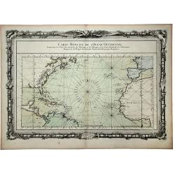
CARTE REDUITE de l' OCEAN OCCIDENTAL, Contenant les Costes Occidentales de l'Europe et de l' Afrique et les Cotes Orientales de l'Amerique . . .
This beautifully engraved chart shows the Atlantic Ocean north of the equator, delineated with rhumb lines. A good portion of each of the continents is shown with major p...
Date: Paris, 1761
Selling price: ????
Please login to see price!
Sold in 2020
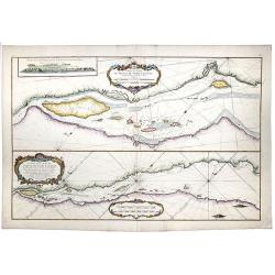
Partie du Cours du Fleuve de Saint Laurent... / Carte du Cours du Fleuve de Saint Laurent depuis Quebec jus.
A map of the banks of the St. Lawrence river from Quebec to the Atlantic in 2 sheets.[The other sheet also present in this auction !]Two charts horizontally oriented wit...
Date: Paris, 1761
Selling price: ????
Please login to see price!
Sold in 2020
Carte du Cours du Fleuve de Saint Laurent. Depuisla Mer jusqu'a Quebec en Deux feuilles . . .
A map of the banks of the St. Lawrence river from Quebec to the Atlantic in 2 sheets. [1 of 2] Two insets with maps entitled "Baye des Sept Isles" and "Les...
Date: Paris, 1761
Selling price: ????
Please login to see price!
Sold in 2020
![[The Americas] AMERIQUE](/uploads/cache/20599-(2)-250x250.jpg)
[The Americas] AMERIQUE
A map depicting both the Americas. With on both sides a descriptionary text. All within an elaborate and very decorative border. Claude Buy de Mornas (d. 1783), géogra...
Date: Paris, 1761
Selling price: ????
Please login to see price!
Sold in 2025
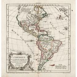
L'Amerique Septentrionale divisé en fes principaux.
A finely engraved map of North America, prepared by Janvier. The map is most notable for it's depiction of Mer de L'Quest or Sea of the West, a great sea, easily the size...
Date: Paris 1762
Selling price: ????
Please login to see price!
Sold
Carte Réduite De L'Isle De Cube..
A well engraved and highly detailed chart that was issued in Neptune americo-septentrionale. This chart is based on Sayer & Bennett's chart that was issued in 1776 an...
Date: Paris, 1762
Selling price: ????
Please login to see price!
Sold
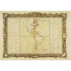
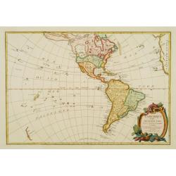
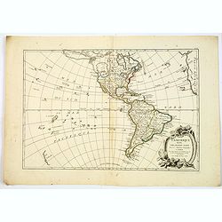
Amérique.
Map of north and south America.Left and right a box with geographical information for America.Prepared by Buy de Mornas, who was a professor of geography and history and ...
Date: Paris 1762
Selling price: ????
Please login to see price!
Sold
L'Amerique divisée Pars Grands Etats. . .
Engraved by Lattré. This map is most notable for its depiction of "Mer de L'Ouest" or "Sea of the West". A great sea, easily the size of the Mediterr...
Date: Paris, 1762
Selling price: ????
Please login to see price!
Sold in 2020
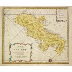
Carte de l\' Isle de la Martinique.
Homann Heirs (of Johann Baptist and Johann Christof) published: Grosser Atlas, 1731, 1737. Geogr. Maior, 1759, Atlas Homannianus, 1762.A map of the island of Martinique.
Date: Nürnberg, 1762
Selling price: ????
Please login to see price!
Sold in 2011

Prospect von Boston gegen der Bucht am Hafen. / Vue de Boston vers le Cale du Port.
A so-called optical print of a fanciful view of Boston harbour, two ships at anchor, British soldiers and men working, and merchandise on shore; an idealized view depicti...
Date: Augsburg, 1762
Selling price: ????
Please login to see price!
Sold
L'Amérique.
General map of America. From Gilles Robert de Vaugondy's Nouvel Atlas Portatif.
Date: Paris, 1762
Selling price: ????
Please login to see price!
Sold in 2012
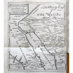
Travels of the Jesuits...(with Kino map of California).
Famous account by John Lockman, illustrated with five fold-out maps and 1 fold-out plate. With the important "Kino" map of California (Passage by land to Califo...
Date: London, 1762
Selling price: ????
Please login to see price!
Sold in 2015
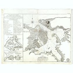
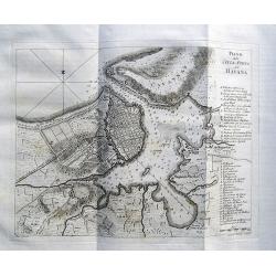
Carte Hydrographique de la Baye de la Havane.. N° 69.
A well engraved and highly detailed of the walled city of Havana and its harbor features inset plans of three forts (La Punta, El Morro, and La Real Fuerza) as well as a...
Date: Paris, 1762
Selling price: ????
Please login to see price!
Sold in 2016
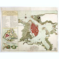
Carte Hydrographique de la Baye de la Havane.. N° 69.
A well engraved and highly detailed of the walled city of Havana and its harbor features inset plans of three forts (La Punta, El Morro, and La Real Fuerza) as well as a...
Date: Paris, 1762
Selling price: ????
Please login to see price!
Sold in 2018

Vue de la Rue du Roi, vers la Porte de la Campagne a Boston.
A vue d'optique of the city of Boston.
Date: Augsburg, 1762
Selling price: ????
Please login to see price!
Sold in 2018
L'Amerique divisée Pars Grands Etats.
Engraved by Lattré. This map is most notable for it's depiction of Mer ou Baye de L'Ouest or Sea of the West. A great sea, possibly the size of the Mediterranean, to flo...
Date: Paris, 1762
Selling price: ????
Please login to see price!
Sold in 2019
![L' AMERIQUE SEPTENTRIONALE divisee en les principaux ETATS.[Great western sea, First State]](/uploads/cache/82867-250x250.jpg)
L' AMERIQUE SEPTENTRIONALE divisee en les principaux ETATS.[Great western sea, First State]
First state for this very important map. Engraved by Lattré. This map is most notable for it's depiction of Mer de L'Quest or Sea of the West, near modern-day Seattle. A...
Date: Paris, 1762
Selling price: ????
Please login to see price!
Sold in 2019
![L'AMERIQUE divisee par Grands Etats.[Bay of the West]](/uploads/cache/83601-250x250.jpg)
L'AMERIQUE divisee par Grands Etats.[Bay of the West]
First state of Janvier's map of America, published in Paris in 1762. It shows a gloriously oversized mythical Bay of the West, unusual Alaskan Archipelago (again complete...
Date: Paris, 1762
Selling price: ????
Please login to see price!
Sold in 2020
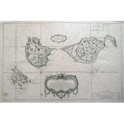
![[Lot of 11 maps and views of the Falkland islands and the Argentinian part of Terra del Fuega. ]](/uploads/cache/20422-(2)-250x250.jpg)
[Lot of 11 maps and views of the Falkland islands and the Argentinian part of Terra del Fuega. ]
Rigobert Bonne (1727-1795), French cartographer. His maps are found in a.o. Atlas Moderne (1762), Raynal's Histoire Philos. du Commerce des Indes (1774) and Atlas Encyclo...
Date: Paris, 1762
Selling price: ????
Please login to see price!
Sold in 2022
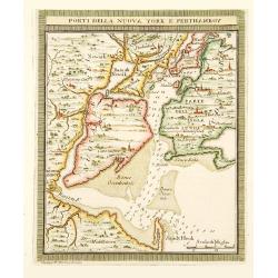
Porti della Nuova York e Perthaboy.
"From ""Il Gazettiere Americano"". Engraved by Guseppe M. Terreni. Interesting chart of Manhattan, part of Long Island, New Jersey. Names are in ...
Date: Livorno 1763
Selling price: ????
Please login to see price!
Sold
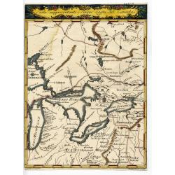
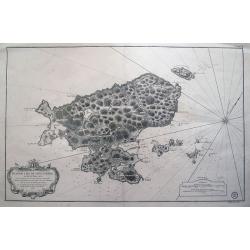
CARTA RAPPRESENTANTE I CINQUE LAGHI DEL CANADA
Rare and important Italian map showing the area of the Great Lakes. Published in "Il Gazzettiere Americano" 1763. Very detailed map of the area with many place...
Date: Livorno, 1763
Selling price: ????
Please login to see price!
Sold
Carte Générale de l' Amérique Séptentrionale ..
Uncommon 3rd version of Le Rouge's Popple key map by Crepy. This state 3 is a variant of state 2 (from the same plate) except: title at top now states: CARTE GÉNÉRALE D...
Date: Paris, ca. 1763
Selling price: ????
Please login to see price!
Sold
Carte de l'Isle de Sainte Lucie..
Attractive double page chart of St. Lucia with inset plans ('Port du Carenage', Cul de sac des Roseaux' and 'Mouillages du Grand Islet et du Choc', illustrating some deta...
Date: Paris 1763
Selling price: ????
Please login to see price!
Sold in 2008
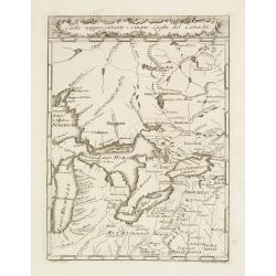
Carta Rappresentante I cinque Laghi del Canada.
Highly detailed map of the Great Lakes and contiguous regions, which appeared in Masi's "Il Gazzettiere Americano." Engraved by A.Scacciati.The map's nomenclatu...
Date: Livorno 1763
Selling price: ????
Please login to see price!
Sold
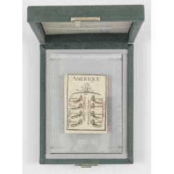
Court card with The nine of Amerique. (Letterweight)
A playing card with a map including detail with "Nouvelle York" and Nassau in the top: St.Augustine in Florida, and Coca, St.Asee, Panuco, Guadalajara, La Guate...
Date: Paris, 1763
Selling price: ????
Please login to see price!
Sold in 2012
Piano della Citta di S.Domingo.
An Italian edition of the Jeffery's plan of Santo Domingo city from the Gazzettiere Americano.
Date: Livorno, 1763
Selling price: ????
Please login to see price!
Sold in 2008
Baye de Hudson et Pays Voisins.
This chart shows the territories of Hudson Bay.The only issue of this version of Bellin's map, slightly larger than the common version. Depths shown by soundings.From Bel...
Date: Paris, 1763
Selling price: ????
Please login to see price!
Sold in 2011
Carta del Corso del maragnone o sia del gran flume dell' Amazonni. . .
Uncommon map of the Amazon by Veremondo Rossi after the important map of Charles Marie de la Condamine (1701-1774) who made a map of the Amazon river in 1745.
Date: c. 1763
Selling price: ????
Please login to see price!
Sold in 2010
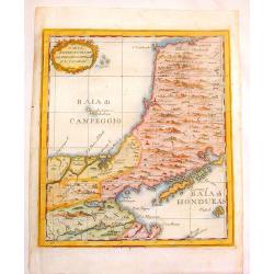
Carta Rappresentante La Baladi Campeggio E \'L Jucatan.
Copper engraved map of the isthmus between the Bays of Honduras & Campeche near Belize and Yucatan. This area had been considered as a possible transoceanic canal rou...
Date: Livorno, 1763
Selling price: ????
Please login to see price!
Sold in 2013
Carta Rappresente Una Parte dlla Baja D'Hudson.
Fine copperplate engraved map of the northern portion of Hudson's Bay in Canada. It is from Masi's "Il Gazzettiere Americano". There is a decorative cartouche.
Date: Livorno, 1763
Selling price: ????
Please login to see price!
Sold in 2015
A New map of North America from the latest discoveries 1763.
From London magazine, January 1763.
Date: London, c.1763
Selling price: ????
Please login to see price!
Sold in 2013
Carte des isles de St Pierre et de Miquelon...
Large scale sea-chart of the French overseas terrirtory Saint Pierre and Miquelon near Newfoundland.Very detailed with topographical information of the islands, also show...
Date: Paris, 1763
Selling price: ????
Please login to see price!
Sold in 2014
Plan de l´Ile de Saint Pierre au Sud de Terre-Neuve...
Large sea chart of Saint-Pierre. Highly detailed showing small islands, reefs, depth soundings, exact topographical details. Decorated with a large title cartouche and a ...
Date: Paris, 1763
Selling price: ????
Please login to see price!
Sold in 2014
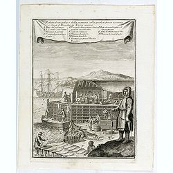
Veduta d'un palco, e della maniera colla quale si pesca acconcia e secca il Baccala in Terra nuova.
This is a view of a cod or fish drying station (stage) in New France or Newfoundland. Includes men fishing for cod, unloading catch from a boat, processing and fileting f...
Date: Livorno, 1763
Selling price: ????
Please login to see price!
Sold in 2015

La caccia dei castori.
Beaver lodge. Includes native Americans hunting beavers using guns or muskets, bows and arrows, waterfall. In the background, hunters skin the beavers.From "Il Gazze...
Date: Livorno, 1763
Selling price: ????
Please login to see price!
Sold in 2015

Figura di un Forte Indiano.
View of a native American settlement or fort. Includes dwellings, domestic animals such as oxen and donkeys, palisades, guns or muskets, and council fire. From "Il G...
Date: Livorno, 1763
Selling price: ????
Please login to see price!
Sold in 2015
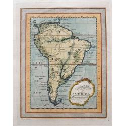
Carta rappresentante l'America Meridionale.
Rare map of South America, published in 1763 (Gazettiere Americano?). Indicates major cities, rivers, and mountains. With a frame style border, nice hand coloring, and a ...
Date: Livorno, 1763
Selling price: ????
Please login to see price!
Sold in 2015
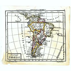
South America.
Uncommon miniature map of South America, engraved by Thomas Kitching for "A New General and Universal Atlas Containing Forty five Maps by Andrew Dury".This mini...
Date: London, 1761-1763
Selling price: ????
Please login to see price!
Sold in 2018
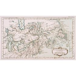
Canada.
Uncommon miniature map of Eastern Canada, engraved by Thomas Kitching for "A New General and Universal Atlas Containing Forty five Maps by Andrew Dury".This min...
Date: London, 1761-1763
Selling price: ????
Please login to see price!
Sold in 2018
Carta rappresentante una parte dlla Baja D'Hudson e le Regioni a Maestro Dell'America Settentrle.
A fine map the northwest corner of Hudson Bay from Masi's "Il Gazzettiere Americano." Published by Gio. Tommaso Masi.
Date: Livorno, 1763
Selling price: ????
Please login to see price!
Sold in 2018
Carta Rappresentante l'Istmo di Darien o'sia di Panama.
A charming map of Panama from Coltellinis Il Gazzettiere Americano. With several town named such as Porto Bello, Panama, Crux di Juan, and Nuova Edinburg. Includes also ...
Date: Livorno, 1763
Selling price: ????
Please login to see price!
Sold in 2017
Piano della Città e Porto dell' Havana.
An interesting map of Havanna, with its harbour, drawn by Giuseppe Pazzi and engraved by Violanta Vanni for Coltellinis Il Gazzettiere Americano.With numerous depth sound...
Date: Livorno, 1763
Selling price: ????
Please login to see price!
Sold in 2017
Carte des Isles de Saint Pierre et Miquelon. . .
A large scale sea-chart of the French overseas territory Saint Pierre and Miquelon near Newfoundland. A very detailed chart with topographical information of the islands,...
Date: Paris, 1763
Selling price: ????
Please login to see price!
Sold in 2020
Saint Pierre, Plan de l'Ile de .., au Sud de Terre-Neuve.
A highly detailed map based on a survey by Fortin, and published by the 'Dépôt Général de la Marine' (the maritime chart printing office of the French government) in ...
Date: Paris, 1763
Selling price: ????
Please login to see price!
Sold in 2022
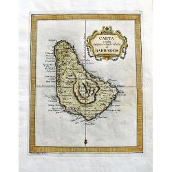
Carta esatta rappresentante l'isola di Barbados.
A fine map of Barbados published in the "Gazzetiere Americano". Engraved by V. Rossi. In nice and decorative colors, and in good condition!
Date: Livorno, 1763
Selling price: ????
Please login to see price!
Sold in 2020
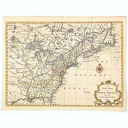
A New Map of North America from the Latest Discoveries.
A nice detailed map of the British Colonies in North America, published at the end of the French & Indian War. The claims of the Carolinas, Virginia and New England n...
Date: London, 1763
Selling price: ????
Please login to see price!
Sold in 2020
Carte de la guyans Francois et l'isle de Cayenne. . .
A detailed and well engraved sea chart of French Guiana and the island of Cayenne, via a large inset. The map was published in 1763 by Bellin (1703-72), a high output car...
Date: Paris, 1763
Selling price: ????
Please login to see price!
Sold in 2020
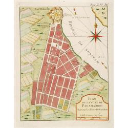
Plan de la Ville de Paramaribo Suivant les Plans Hollandois
Fine map of Panama Bay. From "Petit Atlas Maritime ". Jacques Nicolaas Bellin (1703-1772) was one of the most important and proficient French cartographers of t...
Date: Paris 1764
Selling price: ????
Please login to see price!
Sold
La Nouvelle France où Canada.
This chart shows the territories of New-France and Canada the day before the signature of the treaty of Paris.The only issue of this version of Bellin's map, slightly lar...
Date: Paris 1764
Selling price: ????
Please login to see price!
Sold
Cours du Fleuve Saint Louis..
The mouth of the River Mississippi, depths shown by soundings. The only issue of this version of Bellin's map, slightly larger than the standard version. From Bellin's Pe...
Date: Paris 1764
Selling price: ????
Please login to see price!
Sold
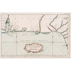
Carte de la coste de la Floride..
Shows the Florida panhandle to Mobile Bay. Little interior data was known. The only issue of this version of Bellin's map, slightly larger than the common version. From B...
Date: Paris 1764
Selling price: ????
Please login to see price!
Sold
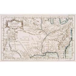
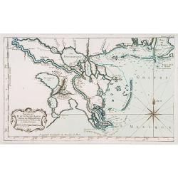
La Louisiane et Pays voisins.
The only issue of this version of Bellin's map, slightly larger than the common version. Excellent detail in the Santa Fe area. More than a dozen rivers, many with names ...
Date: Paris 1764
Selling price: ????
Please login to see price!
Sold
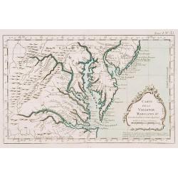
Carte de la Virginie Mari-Land &a.
Shows Virginia, Maryland, Delaware, and southern PA & New Jersey. From Bellin's Petit atlas maritime.Tome I N_35.Jacques Nicolas Bellin (1703-1772) was one of the mos...
Date: Paris 1764
Selling price: ????
Please login to see price!
Sold
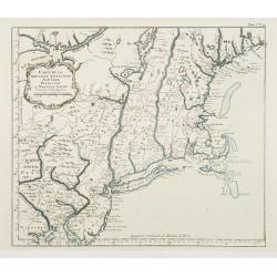
Carte de la Nouvelle Angleterre New York Pensilvanie..
Fine map of New England. From Bellin's Petit atlas maritime.Tome I N_29.Jacques Nicolas Bellin (1703-1772) was one of the most important and proficient French cartographe...
Date: Paris 1764
Selling price: ????
Please login to see price!
Sold
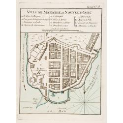
Ville de Manathe ou Nouvelle-Yorc.
This map, which was meant to show New York City, is the printed version of a hand drawn map by J.B.L. Franquelin in 1693.From the Bellin's Petit atlas maritime. In upper ...
Date: Paris 1764
Selling price: ????
Please login to see price!
Sold
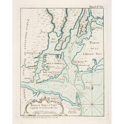
Baye et Port d'Yorc Capitale de la Nouvelle Yorc.
A great little map of the entrance of New York Harbour. The city is shown as a tiny village with other settlements including Neversink, Gravesend, Newark, Woodbridge and ...
Date: Paris 1764
Selling price: ????
Please login to see price!
Sold
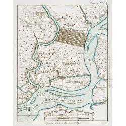
Plan de Philadelphie et Environs.
Nice early plan of the city of Philadelphia and vicinity depicting roads and scattered farms. Decorative title cartouche and fleur-de-lis. With manuscript reference to an...
Date: Paris 1764
Selling price: ????
Please login to see price!
Sold
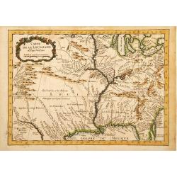
Carte de la Louisiane et Pays Voisins.
A very rare map of Louisiana, Texas and central north America, from Le Commerce de l'Amérique par Marseille, ou Explication des Lettres-Patentes du Roi, portant Reglemen...
Date: Avignon 1764
Selling price: ????
Please login to see price!
Sold in 2016
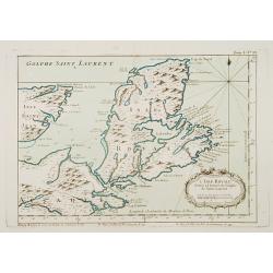
L'Isle Royale située à l'entrée du Golphe de Saint Laurent.
This chart shows the territories of Nova Scotia.The only issue of this version of Bellin's map, slightly larger than the common version. Depths shown by soundings.From Be...
Date: Paris 1764
Selling price: ????
Please login to see price!
Sold
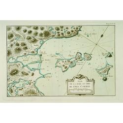
Plan de la Rade et Port de l'Isle Saint-Pierre.
This chart shows a detailed part of the east coast of the island Saint Pierre and Miquelon, which is now-a-day's still French territory.The only issue of this version of ...
Date: Paris 1764
Selling price: ????
Please login to see price!
Sold
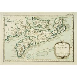
Carte de l'Acadie et Pays Voisins.
Fine chart shows in good detail Prince Edward Island, here called Isle Saint Jean, and covers all of Nova Scotia including Cape Breton. Locates numerous banks south of No...
Date: Paris 1764
Selling price: ????
Please login to see price!
Sold
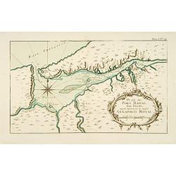
Plan du Port Royal dans l\'Acadie, Appelé Aujourd\' par les Anglois Annapolis Royal.
This chart shows the territories of Port Royal in Acadia.The only issue of this version of Bellin\'s map, slightly larger than the common version. Depths shown by soundin...
Date: Paris 1764
Selling price: ????
Please login to see price!
Sold
Plan de la Baye de Chibouctou nommée par les Anglois Halifax.
This chart shows the territories of Halifax in Nova Scotia, with an inset of the town.The only issue of this version of Bellin's map, slightly larger than the common vers...
Date: Paris 1764
Selling price: ????
Please login to see price!
Sold
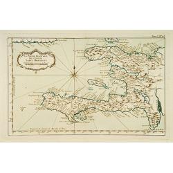
la Partie Francoise de l'Isle de Saint Domingue.
This chart shows the territories of what is today Haiti.The only issue of this version of Bellin's map, slightly larger than the common version. From Bellin's Petit atlas...
Date: Paris 1764
Selling price: ????
Please login to see price!
Sold
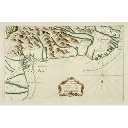
Environs de Leogane et du Port-au-Prince.
A highly detailed map of the area between Leogane and Port au Prince on Hispaniola, with a lovely decorative cartouche.The only issue of this version of Bellin's map, sli...
Date: Paris 1764
Selling price: ????
Please login to see price!
Sold
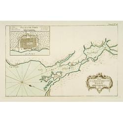
Baye et Ville de Bayaha ou Port Dauphin dans l'Isle de Saint-Domingue.
A detailed chart of the harbour of Banana on the north coast of what is today Haiti.The only issue of this version of Bellin's map, slightly larger than the common versio...
Date: Paris 1764
Selling price: ????
Please login to see price!
Sold
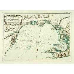
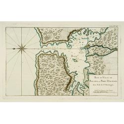
Plan de la Rade et Ville du Petit Goave dans l'Isle de St Domingue.
A very detailed chart of Petit Goave and l'Acul on the north coast of what is today Haiti.The only issue of this version of Bellin's map, slightly larger than the common ...
Date: Paris 1764
Selling price: ????
Please login to see price!
Sold
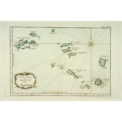
Petites Antilles ou Isle du Vent.. 3ème. Partie.
This chart shows The Windward Islands from the Virgin Islands to Antigua.The only issue of this version of Bellin's map, slightly larger than the common version. Depths s...
Date: Paris 1764
Selling price: ????
Please login to see price!
Sold
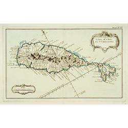
Carte de l'Isle de Saint-Christophe.
This chart shows the island of St. Kitts. Shows interesting topographic details, notes, ports, anchorages, etc.The only issue of this version of Bellin's map, slightly la...
Date: Paris 1764
Selling price: ????
Please login to see price!
Sold
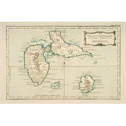
Isle de Guadeloupe les Saintes et Marie Galante.
This chart shows the islands of Guadeloupe, Les Saintes et Marie Galante.The only issue of this version of Bellin's map, slightly larger than the common version. Depths s...
Date: Paris 1764
Selling price: ????
Please login to see price!
Sold