Browse Listings in America
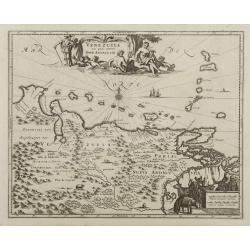
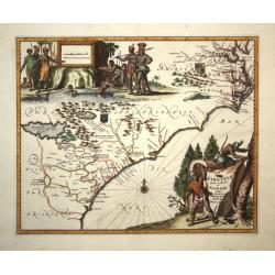
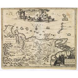
Venezuela cum parte Australi Novae Andalusiae.
Most decorative map with two large cartouches and compass-rose, large group of islands at the mouth of the Orinoco, other islands off Venezuela coast: Margarita, Aruba, C...
Date: Amsterdam, 1671
Selling price: ????
Please login to see price!
Sold
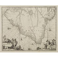
Brasila.
Map of Brazil extending from C. Nasou and Parime Lago to the Mouth of the Rio de la Plata.Oriented with West on top.The cartography of the region is quite primitive. The ...
Date: Amsterdam 1671
Selling price: ????
Please login to see price!
Sold
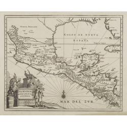
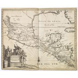
Nova Hispania Nova Galicia Guatimala
A fine map based on the cartography of Hessel Gerritsz. The map includes Mexico through Costa Rica with nice detail.Large pictorial cartouche depicting Native Americans l...
Date: Amsterdam, 1671
Selling price: ????
Please login to see price!
Sold
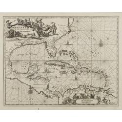
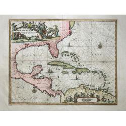
Insulae Americanae in Oceano Septentrionali..
A fine map of the West Indies based on the cartography of Hessel Gerritsz. Encompassing the eastern coast of North America from the Chesapeake through the Gulf of Mexico,...
Date: Amsterdam, 1671
Selling price: ????
Please login to see price!
Sold
Novi Belgii quod nunc Novi Jorck..
A beautifully engraved map, derived from the highly influential map by Visscher. The decoration of this finely engraved map has in the lower right corner not longer a vie...
Date: Amsterdam, 1671
Selling price: ????
Please login to see price!
Sold
Tabula Magellanica qua tierrae del Fuego..
One of the most decorative maps of the extremity of South America, with Patagonia, the Straight of Magellan, Terra del Fuego and the discoveries made by LeMaire and Schou...
Date: Amsterdam, 1671
Selling price: ????
Please login to see price!
Sold
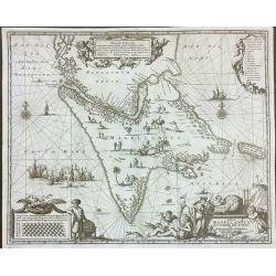
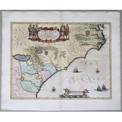
Nova Virginia Tabula.
A beautifully engraved map, derived from the highly influential map by Captain John Smith in 1612, showing Chesapeake Bay and the surrounding area.The decoration of this ...
Date: Amsterdam, 1671
Selling price: ????
Please login to see price!
Sold
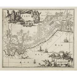
Peru.
Map of Peru from De Nieuwe en onbekende Weereld.. published by Arnold Montanus, which was used by John Ogilby as the basis of his Complete History of America.The map exte...
Date: Amsterdam, 1671
Selling price: ????
Please login to see price!
Sold
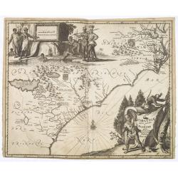
Virginiae partis australis, et Floridae partis orientalis..
This striking map of the Southeast shows the French and English claims in the region marked with their respective coats of arms. The cartography in the southern part of t...
Date: London,1671
Selling price: ????
Please login to see price!
Sold in 2008
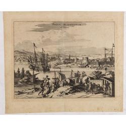
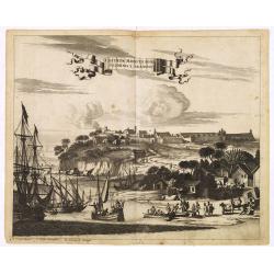
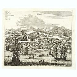
Pagus Hispanorum in Florida.
View of the port of St. Augustine, the oldest city in the United States and the northernmost bastion of the Spanish empire in America (Castillo de San Marcos). With ships...
Date: Amsterdam, 1671
Selling price: ????
Please login to see price!
Sold in 2020
Insulae Americanae in Oceano Septentrionali,
Outstanding map of the West Indies that also incorporates the eastern coast of North America from the Chesapeake through the Gulf of Mexico, Central America and the north...
Date: London,1671
Selling price: ????
Please login to see price!
Sold in 2008
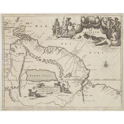
Guiana sive Amazonum Regio.
From : De Nieuwe en Onbekende Weereld published by Jacob van Meurs. Beautiful map of the Guyanas and Brazil, showing the course of the Amazon river and indicates the myth...
Date: Amsterdam, 1671
Selling price: ????
Please login to see price!
Sold in 2008
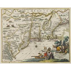
Novi Belgii quod nunc Novi Jorck vocatur, Novae q. Angliae & partis Virginiae . . .
A beautifully engraved map, derived from the highly influential map by Visscher. The decoration of this finely engraved map has in the lower right corner not longer a vie...
Date: Amsterdam, 1671
Selling price: ????
Please login to see price!
Sold in 2008
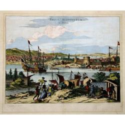
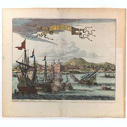
PAGUS HISPANORUM in Florida
Ogilby’s important early view of St. Augustine. With very decorative coloring. This view was originally drawn from Gerrit van Schagen’s work, and depicts a fictional...
Date: London, 1671
Selling price: ????
Please login to see price!
Sold in 2011
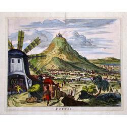
POTOSI
Decorative and highly detailed view of the City of Potosi, now the largest city in the Department of Potosi in Bolivia.Remarkable for its silver mines and the cathedral o...
Date: London, 1671
Selling price: ????
Please login to see price!
Sold in 2011
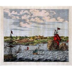
ARX NASSOVII
Early copper engraved view of the Fort Nassau, in Pernambuco, Brazil.Very decorative, with detailed sailing ships in the front, one firing its canons. The fort and villag...
Date: London, 1671
Selling price: ????
Please login to see price!
Sold in 2011
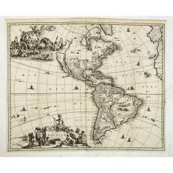
Novissima et Accuratissima Totius Americae Descriptio.
Nice dark impression of John Ogilby's decorative map of America and the Pacific, including New Zealand and California as an island.Engraved by Francis Lamb. Ogilby's map ...
Date: London, 1671
Selling price: ????
Please login to see price!
Sold in 2012
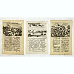
Novum Amsterodamum. . . (together with 2 other scenes in New England)
A good example of one of the earliest available views of New York, from Montanus description of America, taken from a Dutch text edition. Set in a folio page of text desc...
Date: Amsterdam, 1671
Selling price: ????
Please login to see price!
Sold in 2014
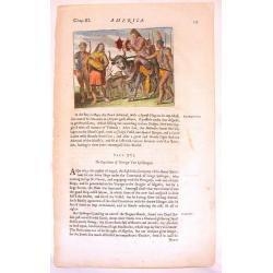
Native Americans Bring Food & Water & Treasure.
Fine Historical hand-colored copperplate engraving featuring Native Americans bringing food and treasure. Arnoldus Montanus (1625–1683) was a Dutch teacher and aut...
Date: Amsterdam. 1671
Selling price: ????
Please login to see price!
Sold in 2013
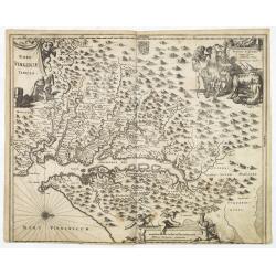
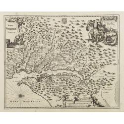
Nova Virginia Tabula.
A beautifully engraved map, derived from the highly influential map by Captain John Smith in 1612, showing Chesapeake Bay and the surrounding area.The decoration of this ...
Date: Amsterdam, 1671
Selling price: ????
Please login to see price!
Sold in 2013
Castrum Mauritij ad Ripam Fluminis S. Francisci.
Impressing copper engraving depicting Fort Maurice, which controlled the ferry on the Rio Francisco.With small letter key at the bottom.
Date: Amsterdam, 1671
Selling price: ????
Please login to see price!
Sold in 2015
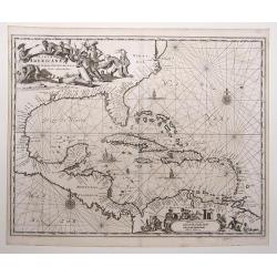
Insulae Americanae in Oceano Septentrionali, cum Terris adiacentibus.
Copper engraved map; overall size 31 x 37 cm by Arnoldus Montanus, from his: 'De Nieuwe en Onbekende Weereld: of Beschryving van America'. Montanus' derivation of Blaeu's...
Date: Amsterdam, 1671
Selling price: ????
Please login to see price!
Sold in 2017
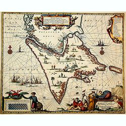
Tabula Magellanica qua tierrae del Fuego. . .
One of the most decorative maps of the extremity of South America, with Patagonia, the Straight of Magellan, Terra del Fuego and the discoveries made by LeMaire and Schou...
Date: Amsterdam, 1671
Selling price: ????
Please login to see price!
Sold in 2016
Tabula Magellanica, qua Tierrae del Fuego, cum Celeberrimis Fretis a F. Magellano et I. Le Maire Detectis Noviss et Accuratissim Descript. Exhibetur
One of the most elaborately decorated maps focusing on the tip of South America with the Strait of Magellan and Le Maire Strait. Several strange creatures are shown in th...
Date: 1671
Selling price: ????
Please login to see price!
Sold in 2020
Urbs Salvador.
A handsome copper engraving of the walled city of San Salvador, with a lettered key at the top left corner.Ships and boats fill the harbor in the foreground. From Arnoldu...
Date: Amsterdam, 1671
Selling price: ????
Please login to see price!
Sold in 2017
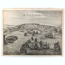
S. Salvador.
A very attractive copperplate engraving of the Brazilian city of San Salvador (Sao Salvador de Bahia de Todos os Santos / The Holy Saviour of the Bay of All Saints), in t...
Date: London, ca 1671
Selling price: ????
Please login to see price!
Sold in 2022
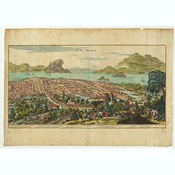
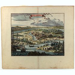
Nova Mexico.
This sweeping panorama of a walled Mexico City was the first published view to identify Tenochtitlan as Mexico City. This is one of the most important views of the great ...
Date: London, ca 1671
Selling price: ????
Please login to see price!
Sold in 2022
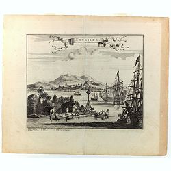
Truxillo.
A lovely copperplate view of Truxillo, situated on the northern coast of Honduras. The engraving shows a number of Spanish ships at anchor in the deep natural harbor, alo...
Date: London, ca 1671
Selling price: ????
Please login to see price!
Sold in 2022
St. Francisco de Campeche.
A delightful view of St. Francesco de Campeche in which a Dutch ship is firing and sinking a ship close by. Other, small craft are seen nearby. In the background a heavil...
Date: London, ca 1671
Selling price: ????
Please login to see price!
Sold in 2022
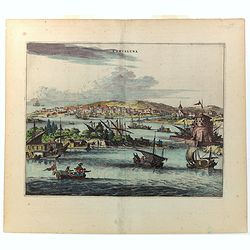
Cartagena.
A richly colored view of what was at the time one of the most important and largest cities in Spanish America. As a result, Cartagena was heavily defended, as is evidence...
Date: London, ca 1671
Selling price: ????
Please login to see price!
Sold in 2022
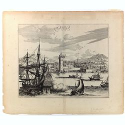
Havana.
This wonderful engraving is a superb example of Ogilby's city views. Although it is a spectacular and lively composition, the image is a little inaccurate in detail. In t...
Date: London, ca 1671
Selling price: ????
Please login to see price!
Sold in 2022
Arx Carolina.
A superb 17th century copperplate engraving displaying Fort Carole and its surrounds on the St. John's River in Florida. It is situated in what today is Jacksonville, in ...
Date: London, ca 1671
Selling price: ????
Please login to see price!
Sold in 2022
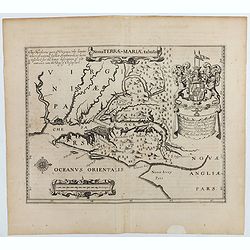
Nova terrae-Mariae tabula.
Double-page engraved map of Chesapeake Bay region, with west oriented at the top, the first printed map of Maryland. Perhaps prepared by Jerome Hawley and John Lewgerand ...
Date: London, ca 1671
Selling price: ????
Please login to see price!
Sold in 2023
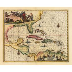
Insulae Americanae in Oceano Septentrionali cum Terris adiacentibus
A fine example of John Ogilby's map of the West Indies, based on Hessel Gerritaz’ chart of 1631 and Blaeu's map of 1635, and Janssons map of 1636. Florida is depicted...
Date: London, 1671
Selling price: ????
Please login to see price!
Sold in 2023
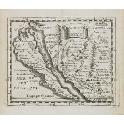
![Noweav Mexiqve. [California as an Island]](/uploads/cache/07724-250x250.jpg)
Noweav Mexiqve. [California as an Island]
Uncommon miniature map of California as a island, from Pierre Duval's La Géographie Universelle dated 1676. The map is derived from Audience de Guadalajara , 1657, by hi...
Date: Paris, 1672
Selling price: ????
Please login to see price!
Sold in 2016
![[Acadie-Québec].](/uploads/cache/64901-250x250.jpg)
[Acadie-Québec].
A very rare map published in "Description Géographique et Historique des Costes de l'Amérique Septentrionale...". The map carries 92 place names. On it Denys ...
Date: Paris, 1672
Selling price: ????
Please login to see price!
Sold
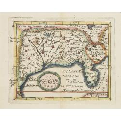
La Floride.
Uncommon miniature map of Florida and Louisiana from Pierre Duval's La Geographie Universeille dated 1676.
Date: Paris, 1672
Selling price: ????
Please login to see price!
Sold in 2013
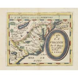
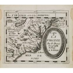
Carte de La Virginie.
Uncommon miniature map of Virginia, from Pierre Duval's La Geographie Universeille . It depicts the now defeated Swedish colony, and the inactive French claim of FLORIDE ...
Date: Paris, 1672
Selling price: ????
Please login to see price!
Sold in 2012
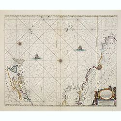
.Pascaerte vande Vlaemsche, Soute, en Caribesche Eylanden, als mede Terra Nova,. . .
This fine and scarce sea chart covers the central Atlantic and extends to include the Maritime Provinces, Antilles and the northwest coast of South America, east to the A...
Date: Amsterdam, 1672
Selling price: ????
Please login to see price!
Sold in 2013

Pascaerte vande Vlaemsche, Soute, en Caribesche Eylanden, als mede Terra Nova,. . .
This fine and scarce sea chart covers the central Atlantic and extends to include the Maritime Provinces, Antilles and the northwest coast of South America, east to the A...
Date: Amsterdam, 1672
Selling price: ????
Please login to see price!
Sold in 2024
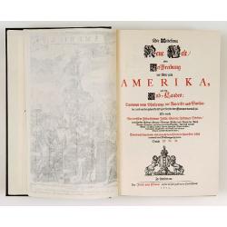
Die Unbekante Neue Welt oder Beschreibung des Welt-teils America
German text edition of the greatest illustrated book on America of the seventeenth century. Included are a large folding map of the western hemisphere as well as maps of ...
Date: Amsterdam 1673
Selling price: ????
Please login to see price!
Sold
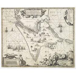
Tabula Magellanica qua tierrae del Fuego. . .
One of the most decorative maps of the extremity of South America, with Patagonia, the Straight of Magellan, Terra del Fuego and the discoveries made by LeMaire and Schou...
Date: Amsterdam, 1673
Selling price: ????
Please login to see price!
Sold in 2013
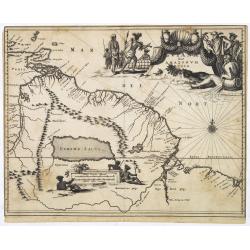
Guiana sive Amazonum Regio.
Map of Guiana and Amazon extending westwards to Trinidad and Margarita Island, dominated by a huge inland sea north of the Amazon.Embellished with decorative title and sc...
Date: Amsterdam, 1673
Selling price: ????
Please login to see price!
Sold in 2025
Venezuela cum parte Australi Novae Andalusiae.
Most decorative map with two large cartouches and compass-rose, large group of islands at the mouth of the Orinoco, other islands off Venezuela coast: Margarita, Aruba, C...
Date: Amsterdam, 1673
Selling price: ????
Please login to see price!
Sold in 2025
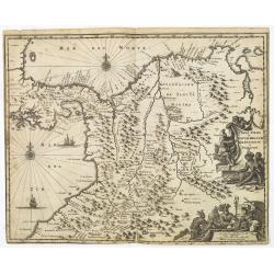
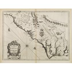
Terra Firma et Novum Regnum Granatense et Popayan.
Detailed map of Panama and northwestern South America derived from the Blaeu/Jansson map of the regionFeaturing ships at sea, two compass roses, and two cartouches depict...
Date: Amsterdam, 1673
Selling price: ????
Please login to see price!
Sold in 2025
Nova Hispania Nova Galicia Guatimala
A fine map based on the cartography of Hessel Gerritsz. The map includes Mexico through Costa Rica with nice detail.Large pictorial cartouche depicting Native Americans l...
Date: Amsterdam, 1673
Selling price: ????
Please login to see price!
Sold in 2013
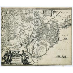
Paraquaria vulgo Paraguay cum adjacentibus.
Detailed map extending from Rio de Janeiro to the Rio de la Plata basin in what is today Argentina.The title cartouche of this highly decorative map features Indians and ...
Date: Amsterdam, 1673
Selling price: ????
Please login to see price!
Sold in 2022
Virginiae partis australis, et Floridae partis orientalis. . .
A beautifully engraved map, derived from the highly influential maps by Mercator and later Blaeu, covering the area from the lower Chesapeake Bay to northern Florida. The...
Date: Amsterdam, 1673
Selling price: ????
Please login to see price!
Sold in 2015
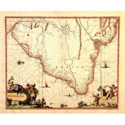
Brasila.
Map of Brazil extending from C. Nasou and Parime Lago to the Mouth of the Rio de la Plata. Oriented with West on top.The cartography of the region is quite primitive. The...
Date: Amsterdam, 1673
Selling price: ????
Please login to see price!
Sold in 2014
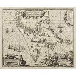
Virginiae partis australis, et Floridae partis orientalis. . . Nova Descriptio.
A map of the East Coast of North America, showing the cost from Chesapeake Bay to the northern part of Florida. The full title in a cartouche at the top reads: Virginiae ...
Date: Amsterdam, 1673
Selling price: ????
Please login to see price!
Sold in 2020
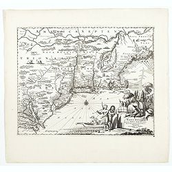
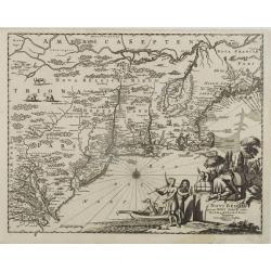
Novi Belgii, quod nunc Novi Jorck vocatur, Novaeque Angliae & Partis Virginiae Accuratissima et Novissima Delineatio.
A beautifully engraved map of the Northeast, extending from the St. Laurence and New England to the Chesapeake and centered on Long Island, which is still shown as an isl...
Date: Amsterdam, 1673
Selling price: ????
Please login to see price!
Sold in 2022
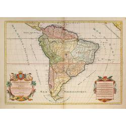
Amérique Méridionale divisée en ses principales Parties.
A very impressive large-scale map. The large decorative title cartouche is balanced by an equally large cartouche around the scale bars, surrounded by Indian figures and ...
Date: Paris, 1674
Selling price: ????
Please login to see price!
Sold in 2009
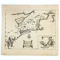
Costes et Rivieres de Virginie, de Mariland et de Nouvelle Angletere. . .
A scarce map that includes the Chesapeake to New England, St. Johns, and Port Royal, showing a single Great Lake "Lake of Herekoys ou Lac des Iroquois." With an...
Date: Paris, Louis Billaine, 1674
Selling price: ????
Please login to see price!
Sold in 2016
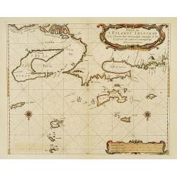
Paskaerte van 'T Eylandt Trinidad ..
An extremely rare and attractive chart of the islands of Trinidad, Margarieta, Granada, Tobago and The Dragon's Mouth between the islands and Venezuela. Upper left the mo...
Date: Amsterdam 1675
Selling price: ????
Please login to see price!
Sold
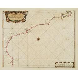
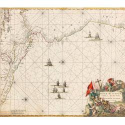
Carte vande Cust van Florida tot de Verginis streckende van Cabo de Carnaveral tot Baya de la Madalena.
An extremely rare and attractive chart of the coast of Florida extending from Cape Canaveral in Florida and following the coasts from South and North Carolina up to Cape ...
Date: Amsterdam 1675
Selling price: ????
Please login to see price!
Sold
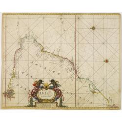
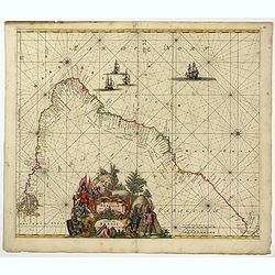
Paskaart van BRASIL van Rio de los Amazones, tot Rio de la Plata.
An eye-catching chart of Brazil. Including 2 compass roses along with a title cartouche.Pieter Goos (ca. 1616-1675) was one of the most important cartographer, engraver, ...
Date: Amsterdam 1675
Selling price: ????
Please login to see price!
Sold
Septentrionaliora Americae e Groenlandia per Fretus Davidis et Hudson, ad Terrum Novam.
The first state of Frederick de Wit's fine chart of Hudson Bay and Arctic Canada.Frederick de Wit (1610-1698) became after the closing of the Blaeu firm one of the most i...
Date: Amsterdam, 1675
Selling price: ????
Please login to see price!
Sold in 2020
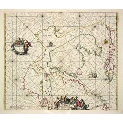
Terra nova, ac maris tractus circa Novam Franciam. . .
Chart of the Atlantic Ocean, showing the east coast of North America from New Foundland till Long Island and the West Indies from Hispaniol to the most eastern tip of Bra...
Date: Amsterdam, 1675
Selling price: ????
Please login to see price!
Sold in 2014
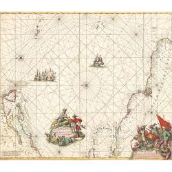
Terra Nova, ac Maris Tractus circa Novam Franciam, Angliam, Belgium, Venezuelam Novam Andalusiam, Guianam et Brasiliam...
A fantastic sea-chart showing the coastlines of North America, the West Indies, and the northern parts of Brazil. The chart extends from Newfoundland and the St Lawrence ...
Date: Amsterdam, 1675
Selling price: ????
Please login to see price!
Sold in 2019
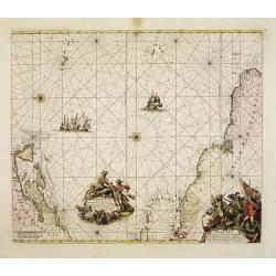
Nova Hispaniae, Chili, Peruviae, et Guatimalae Littorae...
An early edition of this superb chart of the Pacific Ocean, oriented with north to the left of the sheet, showing the coasts of Peru, Chili, Ecuador, Colombia, Honduras, ...
Date: Amsterdam, 1675
Selling price: ????
Please login to see price!
Sold in 2022
Littoria Brasiliae / Pascaert van Brasil.
A truly superb Dutch sea chart of Brazil, with north orientated to the left, published by Frederik de Wit, a man who was rightly famous for his accurate, detailed and hig...
Date: Amsterdam, ca 1675
Selling price: ????
Please login to see price!
Sold in 2022
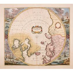
Poli Arctici, et circumiacentium terrarum descriptio novissima. . .
A re-issue of the Hondius' plate, but without the signature. A particularly decorative map of the North Pole. Several Dutch names in Labrador. The toponymy in Canada refl...
Date: Amsterdam, ca.1676
Selling price: ????
Please login to see price!
Sold in 2016
A new description of Carolina.
A wonderful map of Carolina. Incorporated into a 1676 reissue of Speed's 'Prospect Of The Most Famous Parts Of The World'. The map is (in)famous for its depiction of the ...
Date: London, 1676
Selling price: ????
Please login to see price!
Sold in 2021
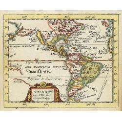
Amerique.
Uncommon miniature map of North and South America, showing California as an island with flat northern coast. Suggestion of D.d'Anien to north of California. Large Terre d...
Date: Paris, 1676
Selling price: ????
Please login to see price!
Sold in 2021
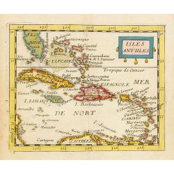
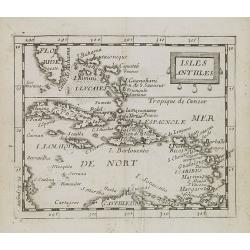
Isles Antilles.
Uncommon miniature map of the Caribbean, including the southern tip of Florida. From Pierre Duval's La Geographie Universeille dated 1676. Following his Cartes de geogr...
Date: Paris, 1676
Selling price: ????
Please login to see price!
Sold in 2014
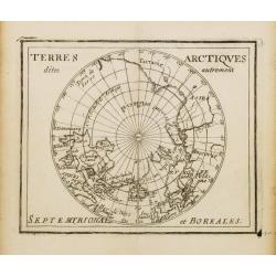
Terres Arctiques.. Septemtrional et Boreales.
Uncommon miniature map of the North Pole, including Iceland, the coast of Russia, Greenland, etc, from Pierre Duval's La Geographie Universeille dated 1676. Following his...
Date: Paris, 1676
Selling price: ????
Please login to see price!
Sold
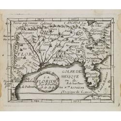
La Floride.
Uncommon miniature map of Florida from Pierre Duval\'s La Geographie Universeille dated 1676. Following his Cartes de geographie in 1657, Pierre Duval published this smal...
Date: Paris, 1676
Selling price: ????
Please login to see price!
Sold in 2008
Noweau Mexique.
Uncommon miniature map of New Mexico from Pierre Duval\'s La Geographie Universeille. Following his Cartes de geographie in 1657, Pierre Duval published this smaller size...
Date: Paris, 1676
Selling price: ????
Please login to see price!
Sold in 2008
Isles Antlles.
Uncommon miniature map of the Caribbean islands from Pierre Duval's La Geographie Universeille dated 1676. Following his Cartes de geographie in 1657, Pierre Duval publis...
Date: Paris, 1676
Selling price: ????
Please login to see price!
Sold in 2008
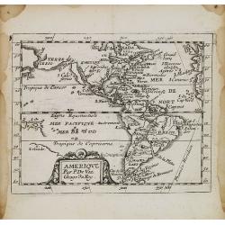
Amérique.
Uncommon miniature map of the Americas from Pierre Duval\'s La Geographie Universeille dated 1676. Following his Cartes de geographie in 1657, Pierre Duval published this...
Date: Paris, 1676
Selling price: ????
Please login to see price!
Sold in 2008
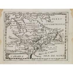
Canada.
Uncommon miniature map of Canada, Great Lakes and the east coast of the United States far south till Chesapeake Bay. Derived from his uncle, Nicolas Sanson\'s map of Le C...
Date: Paris, 1676
Selling price: ????
Please login to see price!
Sold in 2008
Carte de La Virginie.
Uncommon miniature map of Virginia from Pierre Duval\'s La Geographie Universeille dated 1676. It depicts the now defeated Swedish colony, and the inactive French claim o...
Date: Paris, 1676
Selling price: ????
Please login to see price!
Sold in 2008
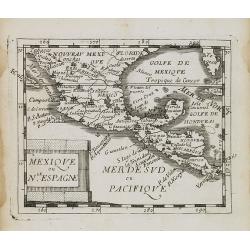
Mexique ou le Nll. Espagne.
Uncommon miniature map of Mexico, central America and the Gulf of Mexico. From Pierre Duval\'s La Geographie Universeille dated 1676. Following his Cartes de geographie i...
Date: Paris, 1676
Selling price: ????
Please login to see price!
Sold in 2008
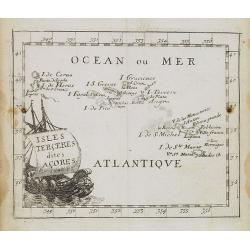
Isles Terceres dites Acores.
Uncommon miniature map of Azores from Pierre Duval's La Geographie Universeille dated 1676. Following his Cartes de geographie in 1657, Pierre Duval published this smalle...
Date: Paris, 1676
Selling price: ????
Please login to see price!
Sold in 2008
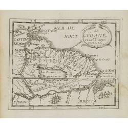
La Guaiane.
Uncommon miniature map of French Guyana in Latin America from Pierre Duval\'s La Geographie Universeille dated 1676. It is bordered to the east by Suriname, to the south ...
Date: Paris, 1676
Selling price: ????
Please login to see price!
Sold in 2008
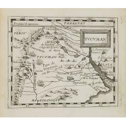
Tucuman.
Uncommon miniature map of part of Argentina, centered on Buenos Aires and Rio La Plata, from Pierre Duval's La Geographie Universeille dated 1676. Following his Cartes de...
Date: Paris, 1676
Selling price: ????
Please login to see price!
Sold in 2008
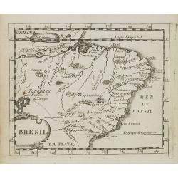
Bresil.
Uncommon miniature map of Brazil from Pierre Duval's La Geographie Universeille dated 1676. Following his Cartes de geographie in 1657, Pierre Duval published this smalle...
Date: Paris, 1676
Selling price: ????
Please login to see price!
Sold in 2008
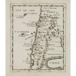
Chili.
Uncommon miniature map of Chile from Pierre Duval's La Geographie Universeille dated 1676. Following his Cartes de geographie in 1657, Pierre Duval published this smaller...
Date: Paris, 1676
Selling price: ????
Please login to see price!
Sold in 2008
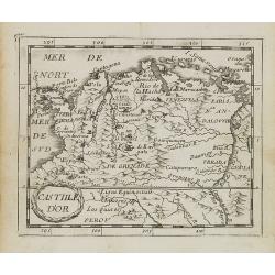
Castille d\'Or.
Uncommon miniature map of Columbia from Pierre Duval\'s La Geographie Universeille dated 1676. Following his Cartes de géographie in 1657, Pierre Duval published this sm...
Date: Paris, 1676
Selling price: ????
Please login to see price!
Sold in 2008

Magellanique.
Uncommon miniature map of Magellan strait and the southern tip of Latin America from Pierre Duval's La Geographie Universeille. Ferdinand Magellan sailed through the stra...
Date: Paris, 1676
Selling price: ????
Please login to see price!
Sold in 2008