Browse Listings in America

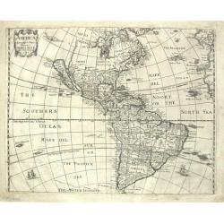
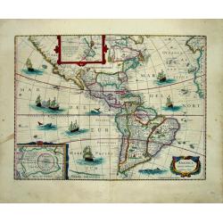
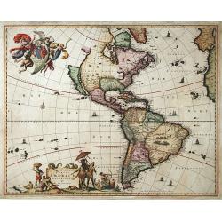
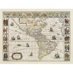
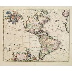
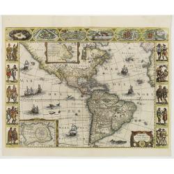
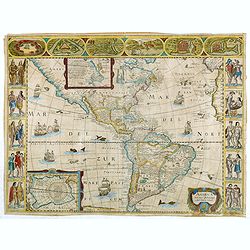
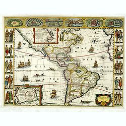
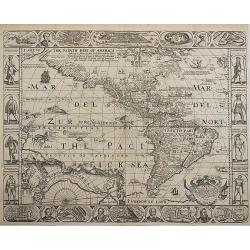
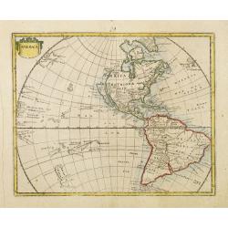
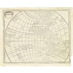
Americae Nova Descriptio.
Final state. According to Philip Burden, "this scarce map is America's first single-sheet map with decorative borders." A re-issue of the 1614 plate by Pieter v...
Date: Amsterdam, 1652
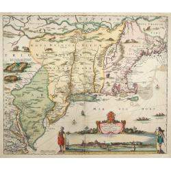
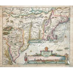
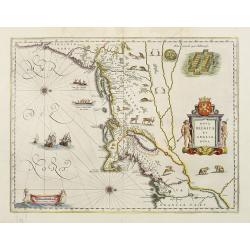
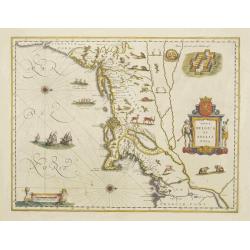
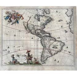
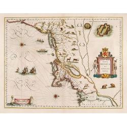
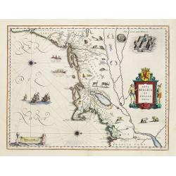
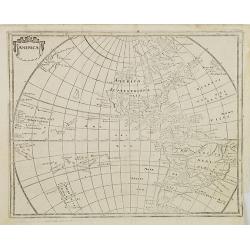
Novi Belgii novae que Angliae nec non partis Virginiae..
The very rare second state: with Fort Kassimier, but without Philadelphia. A classic Dutch map of the east coast from the Chesapeake Bay north to Canada with the famous v...
Date: Amsterdam 1652
Selling price: ????
Please login to see price!
Sold
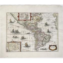
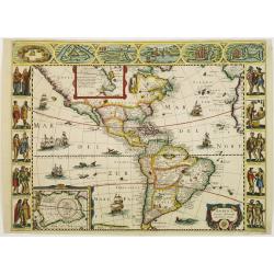
AMERICAE / Descriptio Nova/ Impensis/ Henrici seile/ Will: Trevethen. Sculp/ 1652.
The first state of Henry Seile's map of the Americas, from Peter Heylin's ' Cosmographie '. Reference: Burden, North America, entry and plate 308.
Date: London, 1652
Selling price: ????
Please login to see price!
Sold in 2010
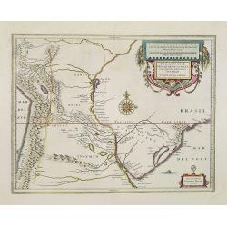
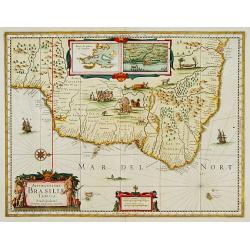
Capitaniarum de Phernambuca, Itama Raca, Paraiba, et Pio Grande Nova Delineatio.
Rare map of part of the coast of Brazil. From Janssonius' 'Atlas Novus'. Rare. Title in cartouche at upper left, scale bars in frame at lower left, and legend in frame at...
Date: Amsterdam, 1652
Selling price: ????
Please login to see price!
Sold in 2009
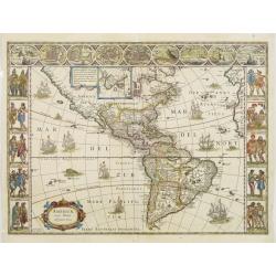
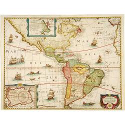
America noviter delineata.
Johannes Janssonius's map of North, Middle and South America. Title in a cartouche at bottom right; beneath it the impressum: 'Amstekodami, Excudit Ioannes Ianssonius'.Sh...
Date: Amsterdam, ca 1652
Selling price: ????
Please login to see price!
Sold in 2020
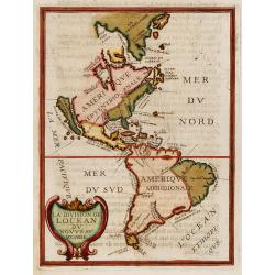
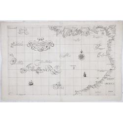
La division de Locean du Nouveau Monde.
California is shown as a large island with nearly flat northern coast with two place names, C.de Mondouno and C.S. Luc. Blank to the north.From "Parallela geographia...
Date: Paris, 1653
Selling price: ????
Please login to see price!
Sold in 2017
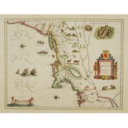
Novi Belgii novaeque Angliae nec non partis Virginiae tabula multis in locis emendata a Iusto Dackers.
This map belongs to the most famous maps of New England. It shows the East coast from the Chesapeake to the St. Lawrence river. The map was firstly published by J. Dancke...
Date: Amsterdam, 1655
Selling price: ????
Please login to see price!
Sold in 2014

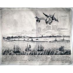
Sir Francis Drake crowned King of California.
Rare 1655 view of Sir Francis Drake, English soldiers paraded and planting the flag while native Californians celebrate and place a crown on Drake's head. From "Newe...
Date: Frankfurt, 1655
Selling price: ????
Please login to see price!
Sold in 2015
![[ Lot of 3 maps] Terra Firma et Novum Regnum.](/uploads/cache/19390-(1)-250x250.jpg)
[ Lot of 3 maps] Terra Firma et Novum Regnum.
Willem Blaeu’s map of Columbia with the Isthmus of Panama. Embellished with two cartouches and two compass-roses. Willem Blaeu, the father of Johan and Cornelis Blaeu, ...
Date: Amsterdam, 1655
Selling price: ????
Please login to see price!
Sold in 2022
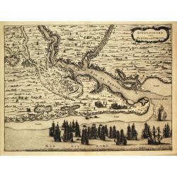
Afbeeldinghe van Pariba ende Forten.
The Dutch fleet before the entrance of the Rio de Paribo. From Isaac Commelin's description of the life and acts of Prince Frederik Hendrik van Nassau (the 'Brasilian').
Date: Amsterdam, 1656
Selling price: ????
Please login to see price!
Sold
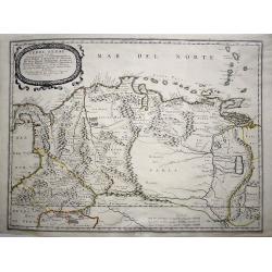
Terre Ferme ou sont les Governations, ou Gouvernemens de Terre Ferme, Cartagene, St. Marthe, Rio De la Hache, Venezuela, Nouvelle Andaluise, Popyan
A beautiful early map of the northern coast of South America, Venezuela and Columbia, showing the course of the Rio de Paria or Yuyapari or Orinaque River, Venezuela's Ca...
Date: Paris, 1656
Selling price: ????
Please login to see price!
Sold in 2020
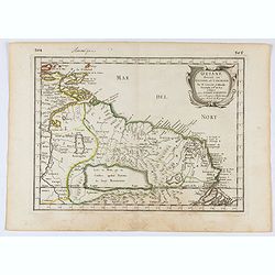
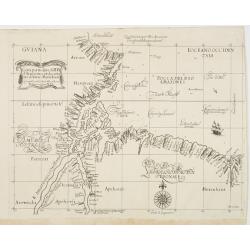
Guiane divisee en Guiane, et Caribane. . .
Map of Guinea prepared by N.Sanson and published by Pierre Mariette. This is a reduced derivative of the famous Sanson map of 1650.Published in an early edition of the sm...
Date: Paris, P. Mariette, 1656
Selling price: ????
Please login to see price!
Sold in 2025
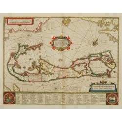
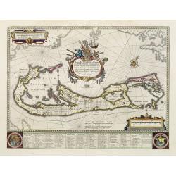
Mappa Aestivarum Insularum, alias Barmudas..
This magnificent map is based on the famous survey by John Norwood of the Bermuda Company in 1618. The map shows the division into the original Tribes and shows the vario...
Date: Amsterdam 1646-1657
Selling price: ????
Please login to see price!
Sold
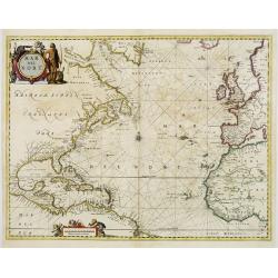
Mar del Nort.
This chart from Johannes Janssonius' sea-atlas 'De Water-Weereld'. The decorative title cartouche shows a native American (as interpreted in Europe!) and various species ...
Date: Amsterdam, 1657
Selling price: ????
Please login to see price!
Sold in 2008
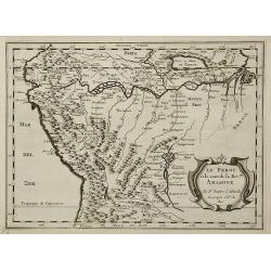
Le Perou et le cours de la Riv.re Amazone ...
Standard map of Peru and the River Amazon prepared by N. Sanson.
Date: Paris, 1657
Selling price: ????
Please login to see price!
Sold in 2011
![Mexico, Regia et Celebris Hispaniae Novae Civitas ... [on sheet with] Cusco, Regni Peru in Novo Orbe Caput](/uploads/cache/91340-250x250.jpg)
Mexico, Regia et Celebris Hispaniae Novae Civitas ... [on sheet with] Cusco, Regni Peru in Novo Orbe Caput
Janssonius rare town-plan of Mexico and Cusco. After Braun & Hogenberg. Latin text on verso. From "Theatrum Urbium Celebriorum totius Belgii sive Germaniae Infer...
Date: Amsterdam, 1657
Selling price: ????
Please login to see price!
Sold in 2010
AMERICA / noviter delineata / Auct: Henrico Hondio 1641 / Amstelodami, Excudit Ioannes Ianssonius
A decorative, original color map of North and South America by the famed Hondius publishing house. This map is noted for its elegant engraving and pleasing layout.Th...
Date: Amsterdam, (1618) 1646-1657
Selling price: ????
Please login to see price!
Sold in 2013
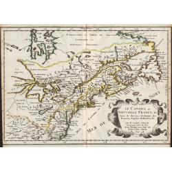
Le Canada, ou Nouvelle France, &c. ...
Map of Canada, from the first edition of the atlas L'Amérique en plusieurs cartes, et en divers traittés de Géographie, et d'Histoire.Nicolas Sanson was to bring about...
Date: Paris, 1657
Selling price: ????
Please login to see price!
Sold in 2012
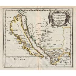
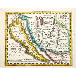
Audience de Guadalajara, Nouveau Mexique, Californie, &c.
Map of California, shown as an island, from the first edition of the atlas L'Amérique en plusieurs cartes, et en divers traittés de Géographie, et d'Histoire.Nicolas S...
Date: Paris, 1657
Selling price: ????
Please login to see price!
Sold in 2012
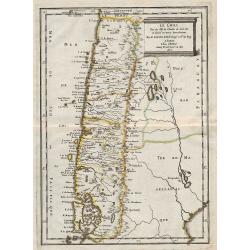
Le Chili ...
Map of Chile, from the first edition of the atlas L'Amérique en plusieurs cartes, et en divers traittés de Géographie, et d'Histoire.Nicolas Sanson was to bring about ...
Date: Paris, 1657
Selling price: ????
Please login to see price!
Sold in 2012
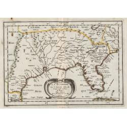
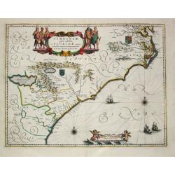
La Floride.
Map of Florida, from the first edition of the atlas L'Amérique en plusieurs cartes, et en divers traittés de Géographie, et d'Histoire.Nicolas Sanson was to bring abou...
Date: Paris, 1657
Selling price: ????
Please login to see price!
Sold in 2013
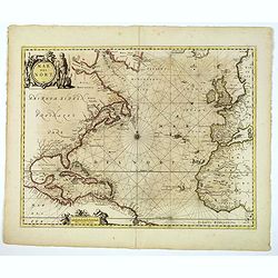
Mar del Nort.
This lovely sea chart is from the Johannes Janssonius' sea-atlas De Water-Weereld. The decorative title cartouche shows a native American (as interpreted by those in Euro...
Date: Amsterdam, 1657
Selling price: ????
Please login to see price!
Sold in 2020
Novissima et accuratissima Totius Americae descriptio..
"""A map of importance...it became the standard representation of North America for a number of years and was copied by other Dutch and English publishers....
Date: Amsterdam 1658
Selling price: ????
Please login to see price!
Sold
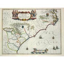
Virginiae partis australis et Floridae paertis orientalis, interjacentiumq3 regionum Nova Descriptio.
Johannes Janssonius, the great rival of Willem Blaeu, was the son-in-law of Jodocus Hondius. Together with Jodocus' son Hendrick, he continued to publish the successive e...
Date: Amsterdam, 1647-1658
Selling price: ????
Please login to see price!
Sold
Virginiae partis australis et Floridae paertis orientalis, interjacentiumq regionum Nova Descriptio.
Johannes Janssonius, the great rival of Willem Blaeu, was the son-in-law of Jodocus Hondius. Together with Jodocus' son Hendrick, he continued to publish the successive e...
Date: Amsterdam, 1647-1658
Selling price: ????
Please login to see price!
Sold in 2017
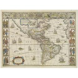
Americae Nova Tabula.
The delineation of the coast and the nomenclature on both the Pacific and Atlantic coasts are basically Spanish in origin and follow the maps of Ortelius and Wytfliet. To...
Date: Amsterdam, 1658
Selling price: ????
Please login to see price!
Sold
Nova Belgica et Anglia Nova.
Orientated with north to the right. This is one of the earliest maps to concentrate solely on this area of the colonies, excluding Virginia and the extreme north east coa...
Date: Amsterdam, 1658
Selling price: ????
Please login to see price!
Sold
Mappa Aestivarum Insularum alias Barmudas.
Blaeu based his work on John Speed's remarkably accurate map of 1626-1627. It shows the island divided into tribes and lots, and below the map itself appear the names of ...
Date: Amsterdam, 1658
Selling price: ????
Please login to see price!
Sold in 2008
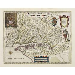
Nova Virginiae Tabula.
The map is based on the first state of Smith's map, 1612, and is slightly larger and more expertly engraved. In 1629 the Hondius plate was purchased by Blaeu who deleted ...
Date: Amsterdam, 1658
Selling price: ????
Please login to see price!
Sold
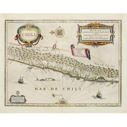
Chili.
Willem Blaeu's very decorative map of Chili with two large and beautiful cartouches, a compass and ships. The modern cities of Santiago (identified on the map as "S ...
Date: Amsterdam, 1658
Selling price: ????
Please login to see price!
Sold in 2012
Nova Belgica et Anglia Nova.
Orientated with north to the right. This is one of the earliest maps to concentrate solely on this area of the colonies, excluding Virginia and the extreme north east coa...
Date: Amsterdam, 1658
Selling price: ????
Please login to see price!
Sold
Americae Nova Tabula.
The delineation of the coast and the nomenclature on both the Pacific and Atlantic coasts are basically Spanish in origin and follow the maps of Ortelius and Wytfliet. To...
Date: Amsterdam, 1658
Selling price: ????
Please login to see price!
Sold
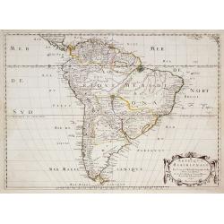
Paraguayo Prov. De Rio De La Plata cum regionibus..
This is an early map showing this northern Patagonia territory. Also showing Rio de Janeiro, Sao Paolo, Santa Cruz of Bolivia, Paraguay, Uruguay, Buenos Ayres, Chili and ...
Date: Amsterdam, 1658
Selling price: ????
Please login to see price!
Sold in 2020
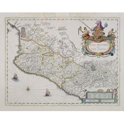
Nova Hispania et Nova Galicia.
Based on Ortelius's map of 1579 which became the basis for many of the seventeenth century maps of the area. Despite the implications in the title, the map does not cover...
Date: Amsterdam, 1658
Selling price: ????
Please login to see price!
Sold in 2013
Brasilia.
A mint copy of this map by Krystof Arciszewski, a Polish general who worked for the Dutch West Indian Company. The map perpetuates various myths including the Parime Lago...
Date: Amsterdam, 1658
Selling price: ????
Please login to see price!
Sold in 2009
Americae Nova Tabula.
The delineation of the coast and the nomenclature on both the Pacific and Atlantic coasts are basically Spanish in origin and follow the maps of Ortelius and Wytfliet. To...
Date: Amsterdam, 1658
Selling price: ????
Please login to see price!
Sold in 2015
Novissima et accuratissima Totius Americae. . .
The second state with privilege along the lower margin. A map of importance. . . it became the standard representation of North America for a number of years and was copi...
Date: Amsterdam, 1658
Selling price: ????
Please login to see price!
Sold in 2013
Novissima et Accuratissima Totius Americae Descriptio per N. Visscher.
An extremely decorative, large and famous map of the Western Hemisphere, showing California as an Island and noticeably, at the lower left corner, a small part of New Zea...
Date: Amsterdm, 1658
Selling price: ????
Please login to see price!
Sold in 2020
America noviter delineata.
Rare map of the America's published in Pierre D'Avity's Les Etats, Empires Royaumes...du Monde... The plate was engraved with figured borders on three sides and is drawn ...
Date: Paris, 1659
Selling price: ????
Please login to see price!
Sold in 2016
America noviter delineata.
Extremely rare map of the America's published in Pierre D'Avity's Les Etats... With figured borders on three sides and drawn from the Picart map of 1644, itself derived f...
Date: Paris 1659
Selling price: ????
Please login to see price!
Sold
America noviter delineata. Auct: Judoco Hondio.
Fine map of the American continent with insets of the South and North Pole on the left hand side.Panels on the left, right and top borders, as in the Blaeu Americas. Note...
Date: Amsterdam 1659
Selling price: ????
Please login to see price!
Sold
Amerique Meridionale . . .
A fine large map of South America. The relatively unknown Amazon region is left without speculation. However, Sanson includes the mythical Lac de Parime with Manoa del Do...
Date: Paris, 1650-1659
Selling price: ????
Please login to see price!
Sold in 2013
America noviter delineata.
Rare map of the America's published in Pierre D'Avity's Les Etats... With figured borders on three sides and drawn from the Picart map of 1644, itself derived from the se...
Date: Paris, 1659
Selling price: ????
Please login to see price!
Sold in 2014
America noviter delineata.
Rare map of the America's published in Pierre D'Avity's Les Etats... With figured borders on three sides and drawn from the Picart map of 1644, itself derived from the se...
Date: Paris, 1659
Selling price: ????
Please login to see price!
Sold in 2016
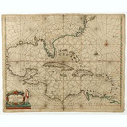
Pascaerte vande Caribische Eylanden, vande Barbados tot aende Bocht van Mexico ‘t Amsterdam By Hendrick Doncker. . .
First state. Rare. “This chart appeared in the first edition of Hendrick Doncker’s Zee-Atlas, of which no surviving example is known” -- Burden. This is an example ...
Date: Amsterdam, 1659
Selling price: ????
Please login to see price!
Sold in 2020
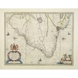
Accuratissima Brasiliae Tabula..
A decorative map with a title cartouche of two natives: the interior features scenes of native life, among napping in a hammock, warfare, cannibalism and indigenous wild ...
Date: Amsterdam 1660
Selling price: ????
Please login to see price!
Sold
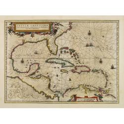
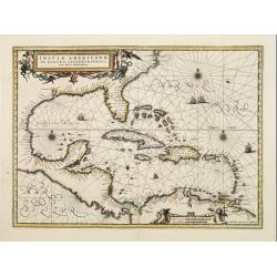
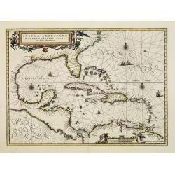
Insulae Americanae in oceano septentrionali..
Finely engraved map, showing the Gulf of Mexico and the West Indian Islands, and the adjacent North and South American coastlines.The cartography is based on the rare Ger...
Date: Amsterdam 1660
Selling price: ????
Please login to see price!
Sold
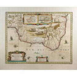
Accuratissima Brasiliae Tabula.
A decorative map of Brazil with a title cartouche of two natives: the interior features scenes of native life, among napping in a hammock, warfare, cannibalism and indige...
Date: Amsterdam 1660
Selling price: ????
Please login to see price!
Sold
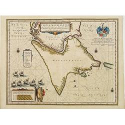
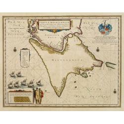
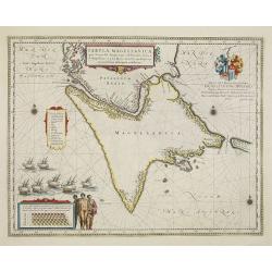
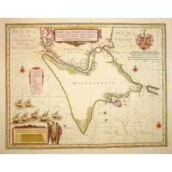
Tabula Magellanica.
A map with Willem Blaeu's signature, but published by his son Joan, of South America's extremity. A dedication to Constantijn Huygens.
Date: Amsterdam 1660
Selling price: ????
Please login to see price!
Sold
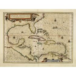
Insulae Americanae in oceano septentrionali..
Finely engraved map, showing the Gulf of Mexico and the West Indian Islands, and the adjacent North and South American coastlines.The cartography is based on the rare Ger...
Date: Amsterdam 1660
Selling price: ????
Please login to see price!
Sold
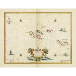
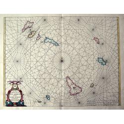
Insulae Açores delineante Ludovico Teisera.
Detailed map of the Azores, dedicated to L.Teisera. A later impression after which the copper plated suffered from several cracks, clearly visible on this strike. Includi...
Date: Amsterdam 1660
Selling price: ????
Please login to see price!
Sold
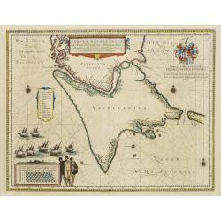
Tabula Magellanica..
A map with Willem Blaeu's signature, but published by his son Joan, of South America's extremity with the Strait of Magellan and Le Maire Strait.The coastlines are depict...
Date: Amsterdam 1660
Selling price: ????
Please login to see price!
Sold
Tabula Magellanica.
A map with Willem Blaeu\'s signature, but published by his son Joan, of South America\'s extremity. A dedication to Constantijn Huygens.
Date: Amsterdam, 1660
Selling price: ????
Please login to see price!
Sold in 2009
Insulae Americanae in oceano septentrionali..
Finely engraved map, showing the Gulf of Mexico and the West Indian Islands, and the adjacent North and South American coastlines.The cartography is based on the rare Ger...
Date: Amsterdam, 1660
Selling price: ????
Please login to see price!
Sold in 2008
Insulae Americanae in oceano septentrionali..
Finely engraved map, showing the Gulf of Mexico and the West Indian Islands, and the adjacent North and South American coastlines.The cartography is based on the rare Ger...
Date: Amsterdam, 1660
Selling price: ????
Please login to see price!
Sold in 2011
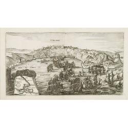
S. SALVADOR.
Charming view of Salvador de Bahia, in Brazil, seen from the ocean. In lower left inset map of Baia de todos os Sanctos.
Date: Frankfurt, 1660
Selling price: ????
Please login to see price!
Sold in 2008
Tabula Magellanica.
A map with Willem Blaeu's signature, but published by his son Joan, of South America's extremity. A dedication to Constantijn Huygens.
Date: Amsterdam, 1660
Selling price: ????
Please login to see price!
Sold in 2017
Accuratissima Brasiliae tabula.
A decorative map with a title cartouche of two natives, in the interior is an inset of Baya de Todos os Sanctos (Salvador), indigenous wild life and cannibal scenes.
Date: Amsterdam, 1660
Selling price: ????
Please login to see price!
Sold in 2009
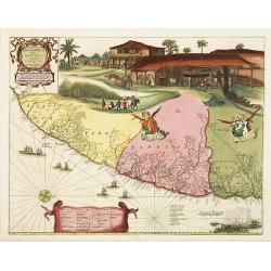
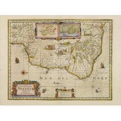
Praefecturae Paranambucae pars Borealis, una cum praefectura de Itamaraca.
This map is one the first maps of Brazil based on Dutch rather than Portuguese interest. The Dutch West India Company, appointed Count Johan Maurits Governor-General of D...
Date: Amsterdam, 1660
Selling price: ????
Please login to see price!
Sold in 2009
Tabula Magellanica.
A map with Willem Blaeu's signature, but published by his son Joan, of South America's extremity with the Strait of Magellan and Le Maire Strait.The coastlines are depict...
Date: Amsterdam, 1660
Selling price: ????
Please login to see price!
Sold in 2022
Pascaerte vande soute Eylanden oste Ilhas de Cabo Verde.
RARE sea chart of the Cape Verde Islands by Johannes van Loon. The islands shown with its towns and anchoring places. Island of Del Fuogo is shown with an erupting volcan...
Date: Amsterdam, c. 1660
Selling price: ????
Please login to see price!
Sold in 2020
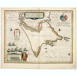
Tabula Magellanica, qua Tierra del fuego. . .
A map with Willem Blaeu's signature, but published by his son Joan, of South America's extremity with the Strait of Magellan and Le Maire Strait.The coastlines are depict...
Date: Amsterdam, 1660
Selling price: ????
Please login to see price!
Sold in 2014
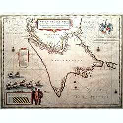
Tabula Magellanica, qua Tierra del fuego. . .
A map with Willem Blaeu's signature, but published by his son Joan, of South America's extremity with the Strait of Magellan and Le Maire Strait.The coastlines are depict...
Date: Amsterdam, 1660
Selling price: ????
Please login to see price!
Sold in 2016
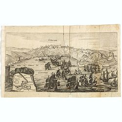
S. SALVADOR.
Charming view of Salvador de Bahia, in Brazil, seen from the ocean. In lower left inset map of Baia de todos os Sanctos.
Date: Frankfurt, 1660
Selling price: ????
Please login to see price!
Sold in 2020
A New Plaine and Exact Map of America.
A very rare map with portraits and views on all sides, published by Robert Walton (1618-1688), London, ca. 1660. Second State.Robert Walton was one of a handful of map pu...
Date: London, 1660
Selling price: ????
Please login to see price!
Sold in 2020
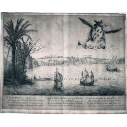
Olinda
This is a reduced version of the famous view of Olinda (Pernabuco, north east of Brazil) derived by the famous work of Barlaeus entitled "Rerum per octennium in Bras...
Date: Amsterdam, ca 1660
Selling price: ????
Please login to see price!
Sold in 2022
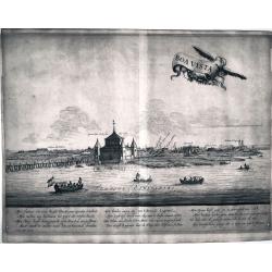
Boa Vista
This is a reduced version of the famous view of Boa Vista derived by the famous work of Barlaeus entitled "Rerum per octennium in Brasilia et alibi gestarum..."...
Date: Amsterdam, ca 1660
Selling price: ????
Please login to see price!
Sold in 2022
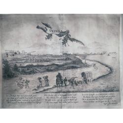
Parayba
This is a reduced version of the famous view of Parayba derived by the famous work of Barlaeus entitled "Rerum per octennium in Brasilia et alibi gestarum...", ...
Date: Amsterdam, ca 1660
Selling price: ????
Please login to see price!
Sold in 2022
Acapitania de Paranambuca
This is a reduced version of the famous view of the Captaincy of Pernambuco or New Lusitania, derived by the famous work of Barlaeus entitled "Rerum per octennium in...
Date: Amsterdam, ca 1660
Selling price: ????
Please login to see price!
Sold in 2022
Carta particolare del'mare del Zur che comincia con il capo S. Francesco nel Peru e finisce con il capo S. Lazaro nella nuova Spagnia.
FIRST EDITION Dudley’s magnificent chart of the Pacific Coast of Central and South America, from the coast of Columbia and Ecuador in the north to the Bay of Honduras i...
Date: Florence 1661
Selling price: ????
Please login to see price!
Sold in 2023
Nova Belgica et Anglia Nova.
Orientated with north to the right. This is one of the earliest maps to concentrate solely on this area of the colonies, excluding Virginia and the extreme north east coa...
Date: Amsterdam 1661
Selling price: ????
Please login to see price!
Sold
Nova Belgica et Anglia Nova.
Orientated with north to the right. This is one of the earliest maps to concentrate solely on this area of the colonies, excluding Virginia and the extreme north east coa...
Date: Amsterdam 1661
Selling price: ????
Please login to see price!
Sold
Carta Particolare dell? Rio d?Amazone con la costa sin al fiume Maranhan
Dudley?s magnificent map shows the mouth of the Amazon River. One of the smaller scale, more specific (?Carta Particolare?) maps and include sailing ships, notes on preva...
Date: Florence 1661
Selling price: ????
Please login to see price!
Sold
Nova Belgica et Anglia Nova.
Orientated with north to the right. This is one of the earliest maps to concentrate solely on this area of the colonies, excluding Virginia and the extreme north east coa...
Date: Amsterdam 1661
Selling price: ????
Please login to see price!
Sold
America.
Rare map of America, showing California as an island after the Briggs model. The continent is clearly after Visscher, c.1658 with the Blaeu type of depiction of the Great...
Date: Wolfenbüttel 1661
Selling price: ????
Please login to see price!
Sold
Nouveau Mexique.
Piere du Val (1618-83), Paris-based cartographer and publisher. Atlases a.o. 'Cartes de Géographie', 1654-88, 'La Géographie universelle', 1661-1712. After his death, h...
Date: Paris, 1661.Paris, 1661
Selling price: ????
Please login to see price!
Sold in 2008
America.
Map of America with California as an island. Interesting map from a German edition of Philipp Clüver's famous Introductionis in Universam geographicam, first published i...
Date: Wolfenbüttel, ca. 1661
Selling price: ????
Please login to see price!
Sold in 2021
America.
Interesting map from a German edition of Philipp Clüver's famous Introductionis in Universam geographicam, first published in Leiden in 1624. Philipp Clüver (1580-1623)...
Date: Wolfenbüttel, ca. 1661
Selling price: ????
Please login to see price!
Sold in 2008
(The coast of Argentina from Cape S. Andreas to Golfo San Jorge.)
A chart from Robert Dudley's sea-atlas Arcano del Mare. It depicts the coast of Argentina from Cape S. Andreas in lattitude 39 o S. to Golfo San Jorge.Robert Dudley (1574...
Date: Florence, 1661
Selling price: ????
Please login to see price!
Sold in 2019
Carta particolare d'Argentina che comincia con il capo S. Andrea e¨ finisce con il capo Matas d'America.
Robert Dudley (1574-1649). English cartographer. The Arcano del Mare (Mystery of the Sea) is "ONE OF THE GREATEST ATLASES OF THE WORLD": it is the first sea-atl...
Date: Florence, 1661
Selling price: ????
Please login to see price!
Sold in 2019