Browse Listings in America
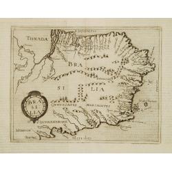
Brasilia.
Very rare sixteenth century map of Brazil.Published in the German edition of José de Acosta's De Natura Nova Orbis, first published in Salamanca, 1588. Acosta was a Span...
Date: Cologne 1598
Selling price: ????
Please login to see price!
Sold
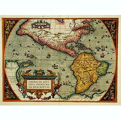
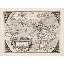
Americae Sive Novi Orbis, Nova Descriptio.
In 1587, a new plate was engraved which appeared in editions from 1588 onwards. Of the three maps, this one is perhaps the most important. Geographically, it is the most ...
Date: Antwerp, 1598
Selling price: ????
Please login to see price!
Sold
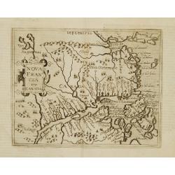
Nova Francia et Canada.
Very rare sixteenth century map: the second printed map to use CANADA in its title, and the second to concentrate on the river and Gulf of St.Lawrence. It summarises sixt...
Date: Cologne 1598
Selling price: ????
Please login to see price!
Sold
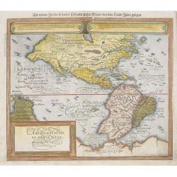
Americae Sive Novi Orbis, Nova Descriptio.
Woodcut map by based on Abraham Ortelius' classic map of 1570, with the huge bulge in the southwest coastline of South America, the Ortelian western coastline of North Am...
Date: Basel 1598
Selling price: ????
Please login to see price!
Sold in 2010
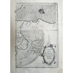
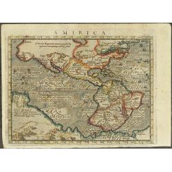
Chica Sive Patagonica et Australis Terra.
Fragment of the famous and rare copper engraved map by Cornelius Wytfliet, published in "Descriptionis Ptolemaicae Augmentum". The map portion on the top shows...
Date: 1598
Selling price: ????
Please login to see price!
Sold in 2011
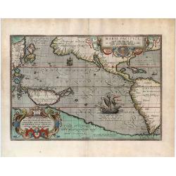
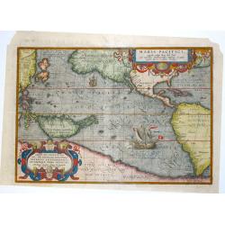
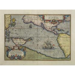
Maris Pacifici, (quod vulgo Mar del Zur) cum regionibus circumiacentibus, insulisque in codem passim sparsis, novissima descriptio.
"One of the most important maps that appeared in the Ortelius atlases, this was the first printed map to be devoted to the Pacific Ocean, the discovery of which is r...
Date: Antwerp, 1598
Selling price: ????
Please login to see price!
Sold in 2020
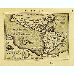
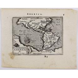
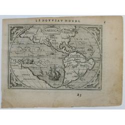
America sive novvs.
Scarce miniature map of the Americas. From the second series of miniature atlas of Ortelius' Epitome. A new series of pocket-size atlases was begun by Philip Galle in 158...
Date: Antwerp, 1598
Selling price: ????
Please login to see price!
Sold in 2012

Maris Pacifici.
From the rare Dutch text edition of the Theatrum of which according to van den Broecke only 100 copies are printed.This was the first printed map to be devoted solely to ...
Date: Antwerp, 1598
Selling price: ????
Please login to see price!
Sold in 2025
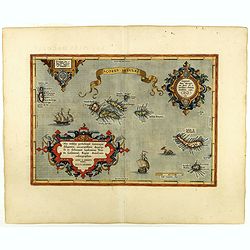
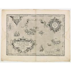
Açores Insulae.
The importance of the Azores at that time was connected with the observation of Columbus that compass variation (i.e. the difference between the real and the magnetic nor...
Date: Antwerp, 1598
Selling price: ????
Please login to see price!
Sold in 2019
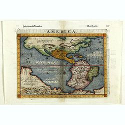
America.
Fine 1598 edition of this early map of America. Girolamo Ruscelli first published the map in his "La Geographi di Claudio Tolomeo" (Venice, 1561), with the pres...
Date: Venice, 1598
Selling price: ????
Please login to see price!
Sold in 2018
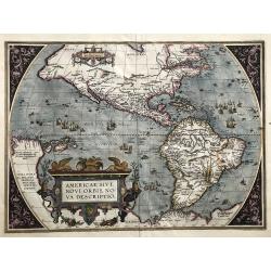
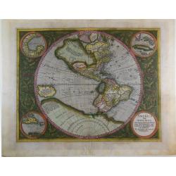
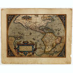
Americae sive Novi Orbis Nova Descriptio (Dutch text edition).
One of the most famous and decorative maps of America.The map, which shows both North and South America, featured in Abraham Ortelius' Theatrum Orbis Terrarum, the first ...
Date: Antwerp, (1587) 1598
Selling price: ????
Please login to see price!
Sold in 2019
Açores Insulae.
The importance of the Azores at that time was connected with the observation of Columbus that compass variation (i.e. the difference between the real and the magnetic nor...
Date: Antwerp, 1598
Selling price: ????
Please login to see price!
Sold in 2020
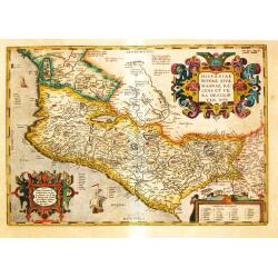
Hispania Novae Sivae magnae, Recens et Vera Descriptio 1579.
Abraham Ortelius’ map of Mexico appeared for the first time in the ‘Additamentum II’. State 2 with dots behind the names in the sea part. Strong decorative embellis...
Date: Antwerp, 1598
Selling price: ????
Please login to see price!
Sold in 2021
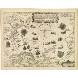
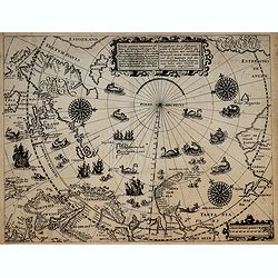
Deliniatio cartae trium navigationum per Batavos..
A major landmark in Arctic cartography incorporating recent voyages including Barents' third voyage to this region, made in 1596-7. A derivative of Willem Barentsz's map ...
Date: Frankfurt 1599
Selling price: ????
Please login to see price!
Sold
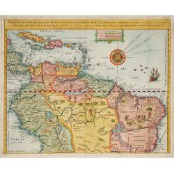
Nova Et Exacta Delineatio Americae Partis Australis Que Est : Brasilia, Caribana, Guiana ?
Very rare map of South America, published by Hulsius. First issue. One of the two maps of Central and South América published in "Brevis & admiranda descriptio ...
Date: Nuremberg 1599
Selling price: ????
Please login to see price!
Sold in 2010
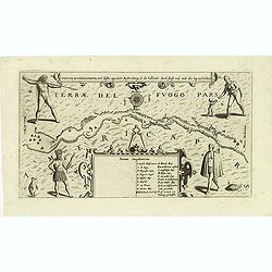
Fretum Magellannicum, und dessen eigentliche Beschribung, so die hollander durch schifft und aush der leng beschreiben.
A fascinating early map of the Strait of Magellan, with north at the bottom, showing ships sailing the passageway between Terrae del Fuogo Pars and Americae Pars. Depicte...
Date: Frankfurt, 1599
Selling price: ????
Please login to see price!
Sold in 2012

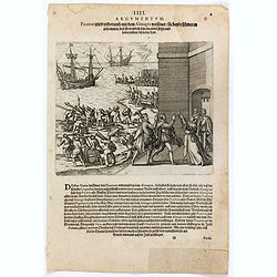
Franciscus Draco cum in locum quendam venis set, à Rege istius regionis convenitur.
This famous and desirable scene was engraved by de Bry native Americans approaching European soldiers and offer gifts. A group of native Americans sit around a fire in a ...
Date: Frankfurt, Matthaeus Becker, 1599
Selling price: ????
Please login to see price!
Sold in 2014
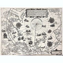
Deliniatio cartae trium navigationum per Batavos. . .
A major landmark in Arctic cartography incorporating recent voyages including Barents' third voyage to this region, made in 1596-7. A derivative of Willem Barentsz's map ...
Date: Frankfurt, 1599
Selling price: ????
Please login to see price!
Sold in 2012
Deliniatio cartae trium navigationum per Batavos..
A major landmark in Arctic cartography incorporating recent voyages including Barents' third voyage to this region, made in 1596-7. A derivative of Willem Barentsz's map ...
Date: Frankfurt, 1599
Selling price: ????
Please login to see price!
Sold in 2017
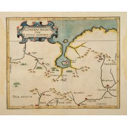
Conibas Regio cum uicinis gentibus.
2nd State. The first printed map of present day central Canada issued by Cornelis van Wytfliet in editions of his Descriptionis Ptolemaicae Augmentum first published in L...
Date: Lovain 1597-1600
Selling price: ????
Please login to see price!
Sold
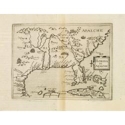
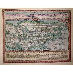
Florida et Apalache.
Very rare map of Florida, including parts of Cuba and the east coast north to the area of the Outer Banks of Carolina. The map is a reduced version of Cornelis Wytfliet m...
Date: Cologne 1600
Selling price: ????
Please login to see price!
Sold
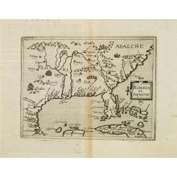
Florida et Apalche.
Very rare map of Florida, including parts of Cuba and the east coast north to the area of the Outer Banks of Carolina. The map is a reduced version of Cornelis Wytfliet m...
Date: Cologne, 1600
Selling price: ????
Please login to see price!
Sold in 2013
Novi Orbis Pars America. . .
Published in Cologne in 1600 this map is from 'Geographisch Handtbuch' with German text on the verso.Quad's map of North America is derived from De Jode and is a beautifu...
Date: Cologne, 1600
Selling price: ????
Please login to see price!
Sold in 2013
America Sive India Nova.
The famous Michael Mercator hemispherical Americas map of 1595, based on his grandfather Rumold Mercator's world map. One of the most important and beautifully engraved e...
Date: Amsterdam, c.1600
Selling price: ????
Please login to see price!
Sold in 2014
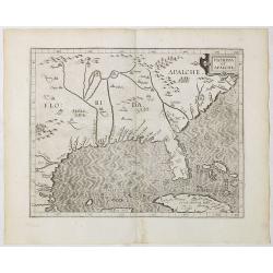
Florida et Apalche.
Wyfliet's map is one of the earliest to focus on the Southeast and to name "Florida", showing part of Texas, Mexico, Cuba, the Bahamas and the Gulf of Mexico.Dr...
Date: Louvain, 1597-1600
Selling price: ????
Please login to see price!
Sold in 2020
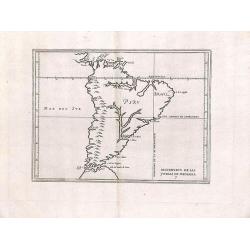
Descripcion de las yndias de mediodia.
Rare map depicting South America by Antonio de Herrera Y Tordesillas. He was the official historian of Spain and the Indies. This simply engraved map of the continent was...
Date: 1601
Selling price: ????
Please login to see price!
Sold in 2013
Maris Pacifici.
This was the first printed map to be devoted solely to the Pacific, and the first to name North and South America separately. It includes most of North and South America,...
Date: Antwerp, 1601
Selling price: ????
Please login to see price!
Sold in 2013
America sive Novus Orbis.
The miniature map of North and South America based on Ortelius' larger map, ornamented with sailing ship. It comes from Latin edition of pocket-size atlas "Epitome T...
Date: Antwerp, 1601
Selling price: ????
Please login to see price!
Sold in 2020
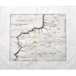
Descripcion del audencia 10 del Quito.
A rare early map with parts of modern day Ecuador, Columbia and Peru. Naming towns, and showing rivers. The earliest map to include information from the previously secret...
Date: Madrid, ca 1601
Selling price: ????
Please login to see price!
Sold in 2022
![Nova et exacta delineatio Americae partis australis.. [2 maps]](/uploads/cache/21606-250x250.jpg)
Nova et exacta delineatio Americae partis australis.. [2 maps]
Very rare map of South America, published by Hulsius. The map is arrayed with wildlife throughout the land, a battle scene in Brazil and mythological figures. The seas ar...
Date: Nuremberg 1602
Selling price: ????
Please login to see price!
Sold
Americae sive novi orbis, nova descriptio.
In 1587, a new plate was engraved which appeared in editions from 1588 onwards. Of the three maps, this one is perhaps the most important. It is the most geographically a...
Date: Antwerp 1602
Selling price: ????
Please login to see price!
Sold
Maris Pacifici.
This was the first printed map to be devoted solely to the Pacific, and the first to name North and South America separately.From the rare Spanish text edition, printed i...
Date: Antwerp, 1602
Selling price: ????
Please login to see price!
Sold in 2009
Western Hemisphere.
Scarce early miniature map of America from the 1602 Ortelius Epitome Theatri Orbis Terrarum. Virginia and California are named and spurious rivers in North America are sh...
Date: Antwerp, 1602
Selling price: ????
Please login to see price!
Sold in 2014
Americae sive novi orbis, nova descriptio.
In 1587, a new plate was engraved which appeared in editions from 1588 onwards. Of the three maps, this one is perhaps the most important. It is the most geographically a...
Date: Antwerp, 1602
Selling price: ????
Please login to see price!
Sold in 2015
Peruviae Auriferae.. La Florida.. Guatecan..
Didacus Mendezius' is mentioned on the map as the author of the map, however this person is unknown in cartographical history. Possibly, it derives from Don Diego Hurtado...
Date: Antwerp 1584-1603
Selling price: ????
Please login to see price!
Sold
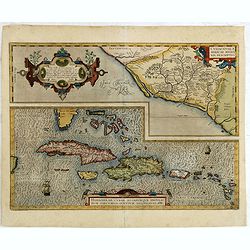
Culiacanae Americae regionis.. / Hispaniolae, Cubae. . .
Two separate virtually identically sized inset maps on one sheet, each with a decorative scroll title cartouche. Culiacanae depicts the coastal and inland western region ...
Date: Antwerp, 1579-1603
Selling price: ????
Please login to see price!
Sold in 2016
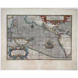
Maris Pacifici, (quod vulgo Mar del Zur) cum regionaribus circumiacentibus, insulisque in eodem passim sparsis, novissima descripto.
This was the first printed map to be devoted solely to the Pacific, and the first to name North and South America separately. It includes most of North and South America,...
Date: Antwerp, 1590-1603
Selling price: ????
Please login to see price!
Sold in 2020
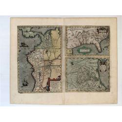
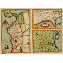
Peruviae Auriferae Regionis Typus. - La Florida - Guastecan.
[3 maps: Florida, Peru and Mexico.] "The Florida map is one of the very few maps printed in the sixteenth century that was based upon original Spanish sources. They ...
Date: Antwerp, 1603
Selling price: ????
Please login to see price!
Sold in 2019
![Tartariae Sive Magni Chami Regni typus. [Alaska and N.America West coast]](/uploads/cache/84445-250x250.jpg)
Tartariae Sive Magni Chami Regni typus. [Alaska and N.America West coast]
Important Map of Asia and North America Included in the World’s First Modern Atlas. It is the earliest obtainable map to name California and is one of the first to incl...
Date: Antwerp, 1603
Selling price: ????
Please login to see price!
Sold in 2021
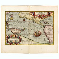
Maris Pacifici, (quod vulgo Mar del Zur) ...
The first printed map of the Pacific Ocean. Date on the map: 1589, first published 1590. Based on Mercator's world map of 1569. This was the first map to focus on the Pac...
Date: Antwerp, 1589 / 1603
Selling price: ????
Please login to see price!
Sold in 2022
America
Beautiful old hand colored engraved map of America. Based on Giovanni d'Anian's Map of America from 1582. Compared to the Western Hemisphere map from Ortelius, Magini inc...
Date: Cologne, 1604
Selling price: ????
Please login to see price!
Sold in 2008
La terra de Hochelaganella Nova Francia.
The first printed plan of Montreal, from Delle navigationi et viaggi. and prepared Jacques Cartier, the great French explorer. visited the village of Hochelaga on the isl...
Date: Venice 1556-1606
Selling price: ????
Please login to see price!
Sold
La terra de Hochelaganella Nova Francia.
The first printed plan of Montreal, from Delle navigationi et viaggi. and prepared Jacques Cartier, the great French explorer. visited the village of Hochelaga on the isl...
Date: Venice, 1556-1606
Selling price: ????
Please login to see price!
Sold
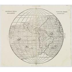
Universale Della Nuovamente. Parte Del Mondo Ritrovata.
Ramusio's map of the Western Hemisphere is the earliest obtainable map to accurately depict the Americas. Printed from block 2. The map is attributed to Giacomo Gastaldi....
Date: Venice, 1565-1606
Selling price: ????
Please login to see price!
Sold in 2009
(MONTREAL). La Terra de Hochelaga nella Nova Francia.
The first printed plan of Montreal, from Delle navigationi et viaggi, and prepared Jacques Cartier, the great French explorer. visited the village of Hochelaga on the isl...
Date: Venice, 1556-1606
Selling price: ????
Please login to see price!
Sold in 2012
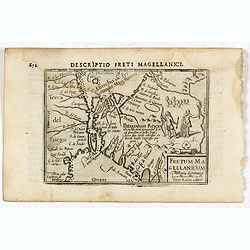
Descriptio Freti Magellanici / Fretum Magellanicum.
A rare miniature map of the Straits of Magellan. Title cartouche on the lower right corner.First published in 1598 in his Caert-Thresoor, the plates were executed by the ...
Date: Amsterdam, Cornelis Claes, 1606
Selling price: ????
Please login to see price!
Sold in 2016
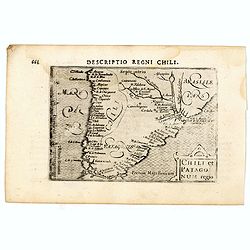
Descriptio Regni Chili / Chili et Patago num regio.
A rare miniature map of Southern part of South America, including Chili,, Brasil, Argentina. Title cartouche on the lower right corner.First published in 1598 in his Caer...
Date: Amsterdam, Cornelis Claes, 1606
Selling price: ????
Please login to see price!
Sold in 2016
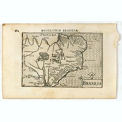
Descriptio Brasiliae / Brasilia.
A rare miniature map of Brazil. Title cartouche on the lower right corner.First published in 1598 in his Caert-Thresoor, the plates were executed by the most famous engra...
Date: Amsterdam, Cornelis Claes, 1606
Selling price: ????
Please login to see price!
Sold in 2016
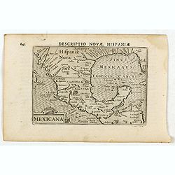
Descriptio Novae Hispaniae / Mexicana.
A rare miniature map of Mexico, including Florida. Title cartouche on the lower left corner.First published in 1598 in his Caert-Thresoor, the plates were executed by the...
Date: Amsterdam, Cornelis Claes, 1606
Selling price: ????
Please login to see price!
Sold in 2016
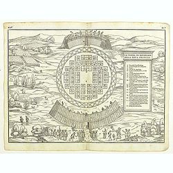
(MONTREAL). La Terra de Hochelaga nella Nova Francia.
The first printed plan of Montreal, and of any American town from Delle navigationi et viaggi, and prepared Jacques Cartier, the great French explorer. visited the villag...
Date: Venice, 1556-1606
Selling price: ????
Please login to see price!
Sold in 2018
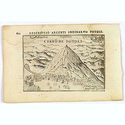
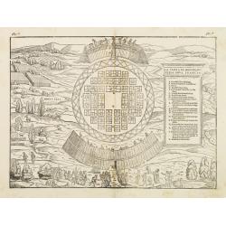
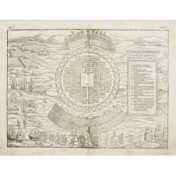
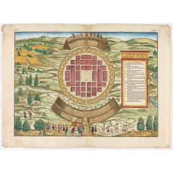
Cerro de Potosi.
This lovely miniature bird's-eye view shows the famous mountain of silver, mined extensively by the Spanish in the 17th century. The view shows miners climbing the mounta...
Date: Amsterdam, 1606
Selling price: ????
Please login to see price!
Sold in 2019
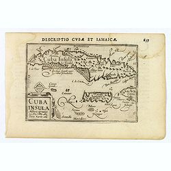
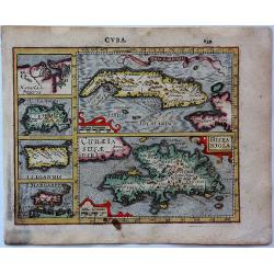
Cuba Insula.
This lovely miniature map shows the Caribbean Islands of Cuba and Jamaica. Published by Petrus Bertius, in Amsterdam at the beginning of the seventeenth century, this map...
Date: Amsterdam, 1606
Selling price: ????
Please login to see price!
Sold in 2020
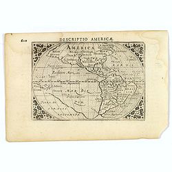
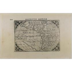
Descriptio Americae.
An attractive miniature map of the continent of the Americas, published by Petrus Bertius, in Amsterdam at the beginning of the seventeenth century.The classic map depict...
Date: Amsterdam, 1606
Selling price: ????
Please login to see price!
Sold in 2019
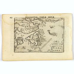
Terra Nova.
This is a fine miniature map by Petrus Bertius of Newfoundland, with the coasts of Quebec, and an unrecognisable Nova Scotia. Sable Island and the Grand Banks are marked,...
Date: Amsterdam, 1606
Selling price: ????
Please login to see price!
Sold
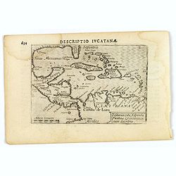
Descriptio Iucatana.
An attractive miniature map of Mexico, Florida, the very north of South America and the Caribbean, published by Petrus Bertius, in Amsterdam at the beginning of the seven...
Date: Amsterdam, 1606
Selling price: ????
Please login to see price!
Sold in 2019
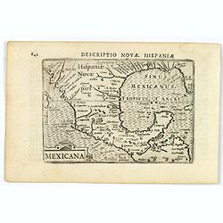
Mexicana.
A miniature map of Mexico, showing the very southern tip of Baia California, the Gulf Coast states, and including the FL 'Panhandle'. Published by Petrus Bertius, in Amst...
Date: Amsterdam, 1606
Selling price: ????
Please login to see price!
Sold in 2023
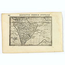
Descriptio Americae Australis.
An attractive miniature map of South America, published by Petrus Bertius, in Amsterdam at the turn of the seventeenth century. Brazil is still seen as a little misshapen...
Date: Amsterdam, 1606
Selling price: ????
Please login to see price!
Sold in 2021
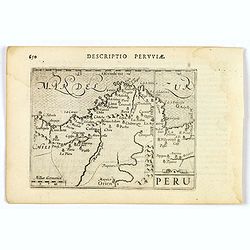
Peru.
An attractive miniature map of Peru, with north orientated to the right, published by Petrus Bertius in Amsterdam at the turn of the seventeenth century. Some interior i...
Date: Amsterdam, 1606
Selling price: ????
Please login to see price!
Sold in 2023
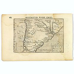
Chili et Patagonum regio.
A rare miniature map of southern part of South America, including Chili, parts of Brazil, and Argentina. Title cartouche on the lower right corner. First published in 159...
Date: Amsterdam, 1606
Selling price: ????
Please login to see price!
Sold in 2019
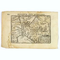
Descriptio Freti Magellanici.
A rare miniature map of the Straits of Magellan. Title cartouche on the lower right corner. Vignette of two local inhabitants. With good map detail. First published in 15...
Date: Amsterdam, 1606
Selling price: ????
Please login to see price!
Sold in 2019
Descriptio Americae.
An miniature map of America continents by Cornelis Claesz – Barent Langenes, with cartography based on that of Ortelius, engraved by Jodocus Hondius, and published by P...
Date: Amsterdam, 1606
Selling price: ????
Please login to see price!
Sold in 2020
(MONTREAL). La Terra de Hochelaga nella Nova Francia.
The first printed plan of Montreal, from Delle navigationi et viaggi, and prepared Jacques Cartier, the great French explorer. visited the village of Hochelaga on the isl...
Date: Venice, 1556-1606
Selling price: ????
Please login to see price!
Sold in 2020
![[Title page] Das sechste Theil der nieuwen Welt oder Der Historien Hieron. Benzo von Meylandt. . .](/uploads/cache/36981-250x250.jpg)
[Title page] Das sechste Theil der nieuwen Welt oder Der Historien Hieron. Benzo von Meylandt. . .
Title page from a German text edition "Das sechste Theil der nieuwen Welt oder Der Historien Hieron. Benzo von Meylandt. . ." being part VI of the Grand Voyages...
Date: Frankfurt, 1607
Selling price: ????
Please login to see price!
Sold in 2016
![Cusco urbs nobilissima & opule[n]tissima Peruani regni in occide[n]tali parte. . .](/uploads/cache/37010-250x250.jpg)
Cusco urbs nobilissima & opule[n]tissima Peruani regni in occide[n]tali parte. . .
Famous town plan of Cuzco, from the first German edition of part VI of de Bry's " Grands Voyages". In this work the conquest of Peu by Pizarro was discribed. Th...
Date: Frankfurt, 1607
Selling price: ????
Please login to see price!
Sold in 2024
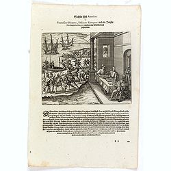
Franciscus Pizarrus, Didocus Almagrus, und ein Priester Ferdinandus Luques machen eine Verbündnuss zusammen.
Francisco Pizarro, Diego de Almagro, and the priest, Hernando de Luque, negotiate a contract while men load cargo onto boats and ships. Includes dwellings, casks, swords,...
Date: Frankfurt, 1607
Selling price: ????
Please login to see price!
Sold in 2023
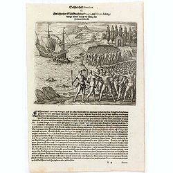
Ein behertzter Schiffknecht dess Pizarri auss Creta bürtig drengt mitten durch die Meng de. . .
In 1528 Pizarro set out on a voyage of true exploration in search of the civilization and riches of Peru, about which he had heard so much from the Indians of Panama. Whe...
Date: Frankfurt, 1607
Selling price: ????
Please login to see price!
Sold in 2023
Pizzarus wird widerumb mit dem Almagro versönet sie beyde schweren zusammen dass sie trewlich bey einander stehn und halten wöllen biss in den Todt.
Francisco Pizarro and Pedro de Almagro swear an oath on the Host held by the priest, Hernando de Luque. The men stand in front of fortifications while ships are loaded by...
Date: Frankfurt, 1607
Selling price: ????
Please login to see price!
Sold in 2016
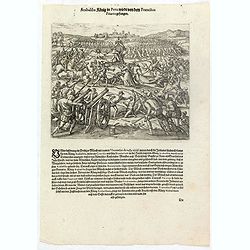
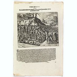
Atabaliba König in Peru wirdt von dem Francisco Pizarro gefangen.
The Inca king, Atahualpa or Atabaliba, holding a scepter in the shape of the sun, is carried on a litter into a scene of warfare. A priest or monk with a crucifix approac...
Date: Frankfurt, 1607
Selling price: ????
Please login to see price!
Sold in 2023
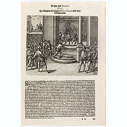
Der Königliche Statthalter Blascus Nunnez Vella wird in ein Gefängnuss gelegt.
This stabbing caused so much resentment among the people of Lima that the new governor, Blanco Núñez Vela, eventually decided he would be safer to transfer his offices ...
Date: Frankfurt, 1607
Selling price: ????
Please login to see price!
Sold in 2023
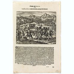
Das sechste Theil der nieuwen Welt oder Der Historien Hieron. Benzo von Meylandt. . .
Conflict between Gonzalo Pizarro and the latest officially appointed governor of Peru, Pedro de la Gasca, reached a climax in 1548 when Gasca’s forces crossed the Apuri...
Date: Frankfurt, 1607
Selling price: ????
Please login to see price!
Sold in 2023
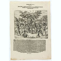
Wie herrlich die Fürsten und Fürstliche Diener in den Occidentalischen Indien zur Erden bestattet werden.
Native Americans bury a chief or king with food, golden vessels, and jewelry. Includes feathered garments and fortifications. The funeral of an Inca king was a ceremony o...
Date: Frankfurt, 1607
Selling price: ????
Please login to see price!
Sold in 2023
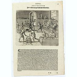
In Peru findet man gar kunstreiche Goldtarbeiter.
Native American method of working gold and silver. Men blow through reeds over a hearth, furnace, or foundry. Other men pound metal with hammers. Other men work the metal...
Date: Frankfurt, 1607
Selling price: ????
Please login to see price!
Sold in 2023
In der Insel Ferri genandt so eine auss den Canarien ist findet man kein ander süss wasser als nur so auss einem eintzigen Baum daselbst täglich herunder trieffet.
Natives of the Canary islands collect water falling from the leaves of a tree. Includes dwellings, vessels, and clouds over the tree. Text page with copper engraving page...
Date: Frankfurt, 1607
Selling price: ????
Please login to see price!
Sold in 2020
![[The battle between rival indians near Bertioga].](/uploads/cache/39414-250x250.jpg)
[The battle between rival indians near Bertioga].
An epic struggle between theTupinambá tribe and their enemy - the Tupiniki tribe.The battle lasted about two hours, during which time both sides howled at each other lik...
Date: Frankfurt, 1607
Selling price: ????
Please login to see price!
Sold in 2018
![[A Portuguese ship comes to look for Staden].](/uploads/cache/39416-250x250.jpg)
[A Portuguese ship comes to look for Staden].
Hans Staden was a German soldier and explorer, who travelled to South America during the mid 16th century. Whilst there he was captured by native Indians in Brazil. He su...
Date: Frankfurt, 1607
Selling price: ????
Please login to see price!
Sold in 2018
![[Native Virginian women sitting around a fire].](/uploads/cache/39419-250x250.jpg)
[Native Virginian women sitting around a fire].
A print of (mostly) native Virginian women sitting around a large campfire, one with plenty of flame and smoke.Theodore De Bry (1528-1598), was born in Liege in modern da...
Date: Frankfurt, 1607
Selling price: ????
Please login to see price!
Sold in 2018
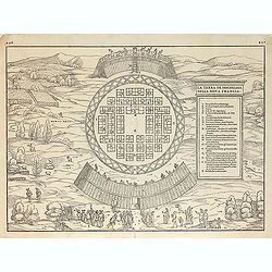
![[The town of Pomeiock].](/uploads/cache/39420-250x250.jpg)
[The town of Pomeiock].
Pomeiock was a village with a strong palisade all round, and a very narrow entrance, which was typical of that region.
Date: Frankfurt, 1607
Selling price: ????
Please login to see price!
Sold in 2017
Cuba.
An attractive copper engraved map of Cuba & the Caribbean islands from Mercator's "Atlas Minor", with larger images of Cuba and Hispaniola, and four smaller...
Date: Amsterdam, 1607
Selling price: ????
Please login to see price!
Sold in 2017
![[The town of Pomeiock].](/uploads/cache/42276-250x250.jpg)
[The town of Pomeiock].
Pomeiock was a village with a strong palisade all round, and a very narrow entrance, which was typical of that region. Inside were a few houses in which only the chief an...
Date: Frankfurt, 1607
Selling price: ????
Please login to see price!
Sold in 2018
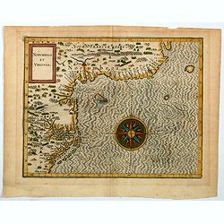
Norumbega et Virginia.
An important map that shows the east coast of North America from the Outer Banks of present day Carolina and on up to Canada. Chesapeake Bay is called "Chesipooc Sin...
Date: Douai, 1607
Selling price: ????
Please login to see price!
Sold in 2020