Sign In or Sign Up
Subscribe to be notified if similar examples become available.
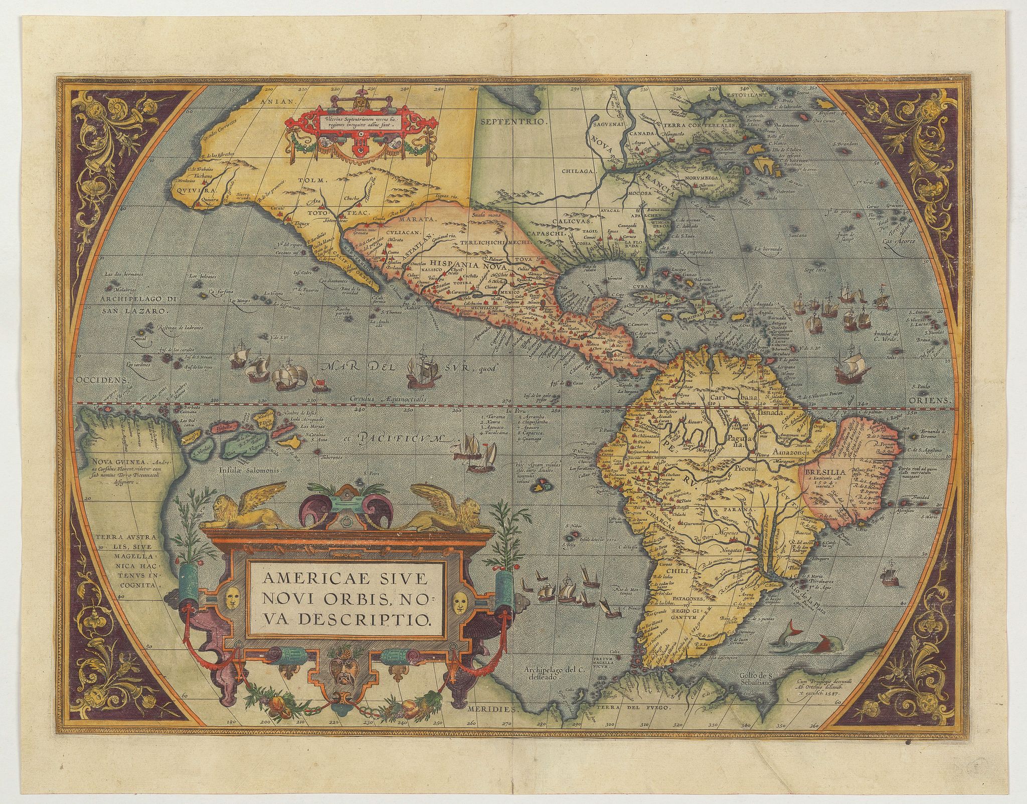
1579 ORTELIUS, A. - Americae Sive Novi Orbis, Nova Descriptio.
Americae Sive Novi Orbis, Nova Descriptio.
| Maker: | ORTELIUS, A. | |
| Date: | Antwerp, 1579 | |
| Colored: | Colored. | |
| Size: | 355 x 488 mm / 14 x 19.2 inches | |
| Condition: | Excellent condition. A diagonal paper crease lower right corner, lightly age toned. Latin text to verso. | |
Selling price: $ Please login to see price!
Sold in 2022
Missed this item!
Add your name to our mailing list and be the first to get notified about our newly added listings.
.
Add this or any of your favorite items in one place.
If you want to save the items permanently, you have to sign in
or create an account first.

 Add/Remove


Description
This is the third edition of Ortelius' map landmark map of the Americas showing the western hemisphere, and showing a prominent bulge in the South American coastline.
An important map because of it's influence on the European perceptions of America.
When the map was first published by Abraham Ortelius at Antwerp in 1570, it was the best map of the Americas available. It was in fact the first of it's kind to achieve-wide circulation through an atlas. North and South America stretch across this single hemisphere map.
North America resembles something like the continent we know today, except the area near Alaska is undefined and the northwest bulges alarmingly westward. South America is a short squat landmass.
The title is decorated with delightful strapwork decorations, very common to the maps in Ortelius’ atlas. In the Atlantic ocean, off what is now Argentina, a sea monster lurks. In the Pacific, a number of ships stream through the water, their sails filled with imaginary winds
.Lower California is correctly shown as a peninsula and America is separated from Asia in the north west. In this state the name of the Azores corrected to Las Acores
.This map has the first appearance of Chesapeake Bay on a map: The inclusion of a large inlet in the east seaboard of North America, labeled with the Indian name "Windansea", reflects the earliest unsuccessful attempts by the English to colonize the area.
It has the very first appearance of the Solomon Islands on a map - the islands were first discovered by Álvaro de Men dana de Naira in 1568, however, they did not appear on a printed map until Ortelius's third Americas map. New toponyms (place names) have been added in California, namely Ortelius adds the name "California". He also adds "C. Mendocino", which was discovered by Juan Rodriquez Cabrillo in 1542. while R. de los stretches is also added.
Ortelius's name and date (1587) appear in the lower right corner. The present map comes from Abraham Ortelius's Theatrum Orbis Terrarum (or "Theater of the World"), which is widely considered to be the first true modern atlas. The Theatrum was the best available summary of sixteenth-century cartographic knowledge, covering much of the exploration of the world in the century following the discovery of America.
The atlas was first published in 1570 in Antwerp, and it was published consistently until 1612.
Reference: Van Den Broecke 11, Burden 64; Schwartz & Ehrenberg 69. KAP
Abraham Ortelius (1527-1898)
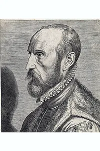 Abraham Ortel, better known as Ortelius, was born in Antwerp and, after studying Greek, Latin, and mathematics, started his career as a cartographer. Later, together with his sister, he became a seller of books, prints and maps.
Abraham Ortel, better known as Abraham Ortelius, was born in Antwerp and, after studying Greek, Latin, and mathematics, started his career as a cartographer. Later, together with his sister, he became a seller of books, prints and maps.
Traveling widely, especially to the great book fairs, his business prospered and he established contacts with the literati in many lands. On one such visit to England, possibly seeking temporary refuge from religious persecution, he met William Camden, whom he is said to have encouraged to produce the Britannia.
A turning point in his career was reached in 1564 with the publication of a World Map in eight sheets of which only one example is known: other individual maps followed and then - at the suggestion of a friend - he gathered together a collection of maps from contacts among European cartographers and had them engraved in uniform size and issued in 1570 as the Atlas of the Whole World.
Although Lafreri and others in Italy had published collections of 'modern' maps in book form earlier, the Theatrum was the first uniformly sized, systematic collection of maps and can be called the first atlas, although that term itself was not used until twenty years later by Mercator.
Abraham Ortelius became the Royal Cartographer to Philip II, King of Spain. Philip sent him a gold necklace worth one thousand ducats. He died on 28 June 1598 at age 71.
Map coloring
At age 19, Abraham Ortels' name appeared in the register of the guild of St Luke as "afsetter," or colorist of maps and prints. He appears to have reached a very advanced level of skill in this craft, as some customers kept insisting on buying atlases he colored himself, even after he established himself as a publisher and cartographer/merchant.
Ortelius was never married and lived with his sister Anna, a situation that remained unchanged throughout his life.
Real prosperity came with the publication of his atlas in 1570, and his sister Anne took over coloring and remained a competent colorist for the rest of her life. Incidentally, children did most map coloring at this time.
FAQ - Guarantee - Shipping
This item is available for immediate purchase when a "Add to Cart" or "Inquire Now" button is shown.
Items are sold in the EU margin scheme
Payments are accepted in Euros or US Dollars.
Authenticity Guarantee
 We provide professional descriptions, condition report (based on 45 years experience in the map business)
Paulus Swaen warrants the authenticity of our items and a certificate of authenticity is provided for each acquired lot.
Condition and Coloring
We indicate the condition of each item and use our unnique HiBCoR grading system in which four key items determine a map's value: Historical Importance, Beauty, Condition/Coloring and Rarity.
Color Key
We offer many maps in their original black and white condition. We do not systematically color-up maps to make them more sellable to the general public or buyer.
Copper engraved or wood block maps are always hand colored. Maps were initially colored for aesthetic reasons and to improve readability. Nowadays, it is becoming a challenge to find maps in their original colors and are therefor more valuable.
We use the following color keys in our catalog:
Original colors; mean that the colors have been applied around the time the map was issued.
Original o/l colors; means the map has only the borders colored at the time of publication.
Colored; If the colors are applied recently or at the end of the 20th century.
Read more about coloring of maps [+]
Shipping fee
A flat shipping fee of $ 30 is added to each shipment by DHL within Europe and North America. This covers : International Priority shipping, Packing and Insurance (up to the invoice amount).
Shipments to Asia are $ 40 and rest of the world $50
We charge only one shipping fee when you have been successful on multiple items or when you want to combine gallery and auction purchases.
Read more about invoicing and shipping
FAQ
Please have a look for more information about buying in the BuyNow gallery
Many answers are likely to find in the general help section.
My Collection+

With My Collection+ you can collect all your favorite items in one place. It is free, and anyone can create his or her virtual collection.
Unless you are logged in, the item is only saved for this session. You have to be registed and logged-in if you want to save this item permanently to My Collection+. Read More[+]
Register here, it is free and you do not need a credit card.
Add this item to My Collection+ or click the following link to see My Collection+.
|
Digital Image Download Paulus Swaen maintains an archive of most of our high-resolution rare maps, prints, posters and medieval manuscript scans. We make them freely available for download and study. Read more about free image download |
Click the image for a free small image download. |
YOUR RIGHT TO CANCEL THE PURCHASE OF A LOT
In accordance with the EU Consumer Rights Directive and habitually reside in the European Union you have the right to cancel the contract for the purchase of a lot, without giving any reason.
The cancellation period will expire 14 calendar days from the day after the date on which you or a third party (other than the carrier and indicated by you) acquires, physical possession of the lot. To exercise the right to cancel you must inform Paulus Swaen Inc, of your decision to cancel this contract by a clear statement (e.g. a letter sent by post, or e-mail.
To meet the cancellation deadline, it is sufficient for you to send your communication concerning your exercise of the right to cancel before the cancellation period has expired.
