Browse Listings in Africa
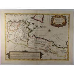
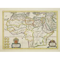
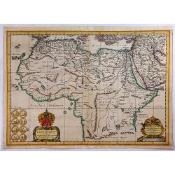
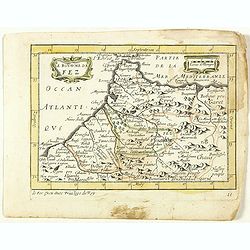
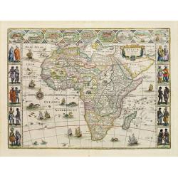
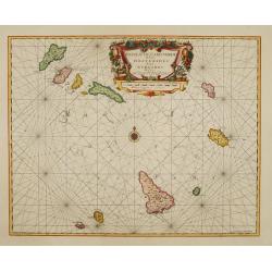
Africae Propriae Tabula. . .
A fine example of Jansson's map of Sicily and North Africa. Decorative map showing the North African coast (Tunisia), Malta and its neighbouring islands, and a part of S...
Date: Amsterdam, 1657
Selling price: ????
Please login to see price!
Sold in 2019
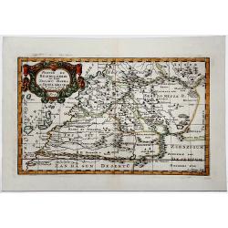
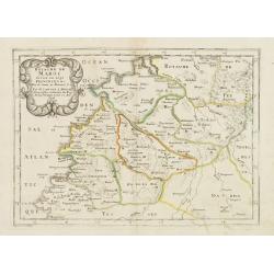
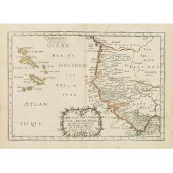
PARTIE DU BILEDULGERID ou sont TESSET, DARHA et SEGELMESSE &c.
A very fine decorative map of Morocco and the Canary Islands. In upper left hand corner decorative title cartouche. Engraved by A.de Winter.
Date: Paris 1657
Selling price: ????
Please login to see price!
Sold in 2019
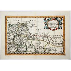
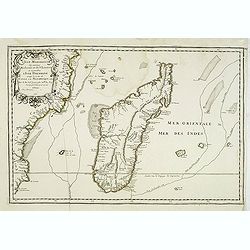
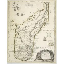
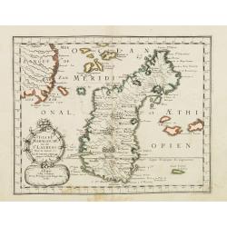
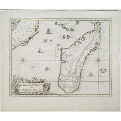
ISLE DE MADAGASCAR ou de St. LAURENS.
Very fine map of Madagascar, first published by Sanson in 1657. A detailed map of Madagascar and near islands.Sanson notes the source of his map as Livio Sanuto and other...
Date: Paris 1657
Selling price: ????
Please login to see price!
Sold in 2019
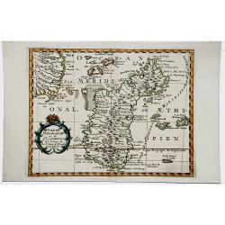
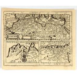
Partie de BARBARIE ou Sont les ROYAUMES de TUNIS et TRIPOLI.
Very decorative map of part of the Mediterranean Coastlines o Tunisia and Libya, first published by Nicholas Sanson in 1657.
Date: Paris, 1657
Selling price: ????
Please login to see price!
Sold in 2019
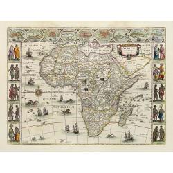
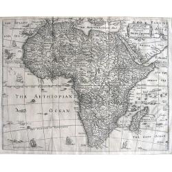
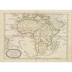
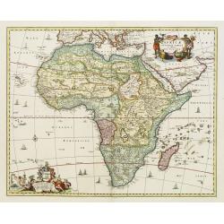
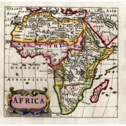
Africae nova descriptio.
Much of the geographical information is still based on the Ptolemaic maps, with the Nile shown with its source in the Lakes Zaire and Zaflan. Also included are various ot...
Date: Amsterdam, 1658
Selling price: ????
Please login to see price!
Sold
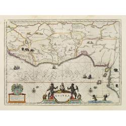
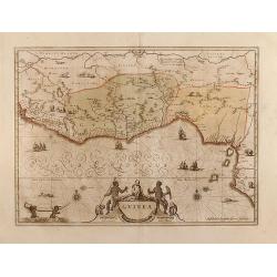
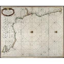
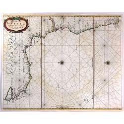
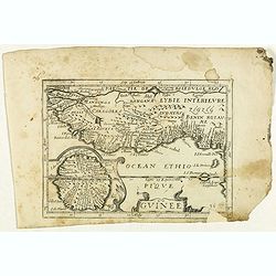
Guinea.
An attractive map covered with intersecting rhumb lines and decorated with monkeys, lions, elephants and native figures. With a dedication to Amsterdam anatomist and phys...
Date: Amsterdam, 1658
Selling price: ????
Please login to see price!
Sold in 2013
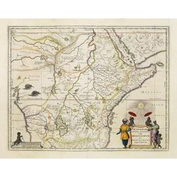
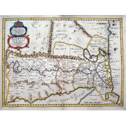
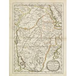
Aethiopia Superior vel Interior vulgo Abissinorum.
An attractive map of the Eastern African and the fictitious kingdom of Prester John. The map shows a major section of central and eastern Africa including Mozambique nort...
Date: Amsterdam, 1658
Selling price: ????
Please login to see price!
Sold in 2010
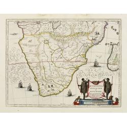
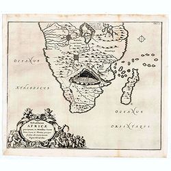
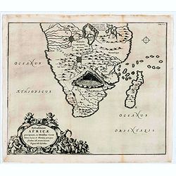
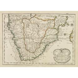
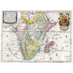
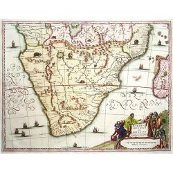
Aethiopia inferior, vel exterior.
The standard map of South Africa throughout the 17th century. The lake out of which the 'Zambere' -the Zambesi- flows is probably based on reports of Lake Ngami, undiscov...
Date: Amsterdam, 1658
Selling price: ????
Please login to see price!
Sold in 2016

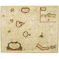
De Kust van Barbarien. . . / De Reede voor de Stadt Angra. . . / De Eylanden van Madera. . . / De Vlaamsche Eylanden By Jacob Colom. . . /
Rare of the Canaries. Lower right pagination number 35. Unusually large scale chart. Eight charts on one sheet, with on verso Dutch text and two wood cut profiles of Mar...
Date: Amsterdam, 1658
Selling price: ????
Please login to see price!
Sold in 2018
Guinea
Very attractive map of Guinea and Benin. Various animals and ships are shown.Dutch text on verso.
Date: Amsterdam, 1660
Selling price: ????
Please login to see price!
Sold in 2013
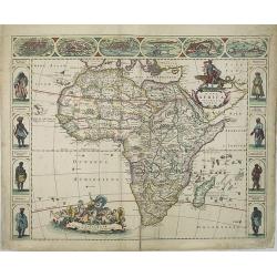
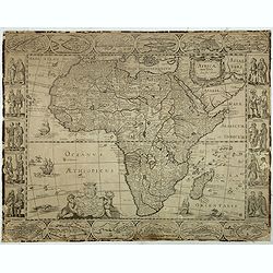
Nova Africa descriptio.
A beautifully engraved and most attractive 'carte a figures' of the African continent. Bordered, above, by panels showing panorama's of Cairo, Alexandria, Algiers, Tunis,...
Date: Amsterdam, 1660
Selling price: ????
Please login to see price!
Sold in 2009
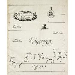
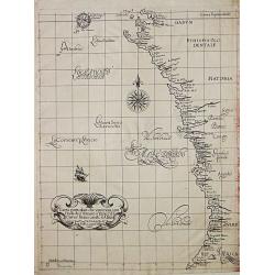
Carta particolare del mare Mediterraneo che comincia con il capo Bogia è Finisce con il porto de tre Croce.
Robert Dudley (1574-1649). English geographer. His rare atlas 'Arcano del Mare' was the first English sea-atlas, the first with charts -all in Mercator-projection- of the...
Date: Florence, 1661
Selling price: ????
Please login to see price!
Sold in 2009
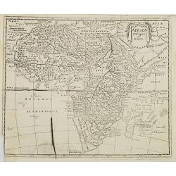
Africa antiqua et Nova.
Interesting map of Africa from a German edition of Philipp Clüver's famous Introductionis in Universam geographicam, first published in Leiden in 1624. Philipp Clüver (...
Date: Wolfenbüttel, later than 1661
Selling price: ????
Please login to see price!
Sold in 2008
Carte particolare che comincia con l'Isole di S. Tomasso e Tome e c. d' S. Clara e finisce con il. c. d' Aldeas.
Chart of Gabon, Congo, Zaire and Angola] Carte particolare che comincia con l'Isole di S. Tomasso e Tome e c. d' S. Clara e finisce con il. c. d' Aldeas. Description: Rob...
Date: Florence, 1661
Selling price: ????
Please login to see price!
Sold in 2019
Africae Antiquae, et quarundam Europae Asiaeque Adiacentium Regionum, accurata delineatio, ad Historiarum lucem edita a Nicolao Blancardo, Batavo, Leidensi, Historiarum et Politices Professore.
Historical map of the Northern part of Africa dedicated to Nikolaas Blankaart (1624-1703). Published in a Latin text edition of J. Janssonius' Historical Atlas from 1662.
Date: Amsterdam, 1662
Selling price: ????
Please login to see price!
Sold in 2011
Africae Antiquae, et quarundam Europae Asiaeque Adiacentium Regionum.
A striking map of the northern and central portion of the African continent. The source of the Nile, on the Ptolemaic model, begins from the lakes Zaire and Zaflan, near ...
Date: Amsterdam, 1662
Selling price: ????
Please login to see price!
Sold in 2018
La Barbarie et l'Egypte.
Scarce map of the African coastline of the Mediterranean, with two inset maps Egypt and Carthage published by Antoine de Fer in 1661 or 1662 in "Cartes de géographi...
Date: Paris, Antoine de Fer, 1657 but 1661 or 1662
Selling price: ????
Please login to see price!
Sold in 2020
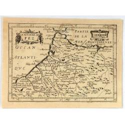
Le Royaume de Fez. (11).
Scarce map of the kingdom of Fes in Morocco published by Antoine de Fer in 1661 or 1662 in "Cartes de géographie revues et augmentées". With Antoine de Fer's ...
Date: Paris, Antoine de Fer, 1657 but 1661 or 1662
Selling price: ????
Please login to see price!
Sold in 2020
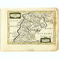
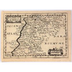
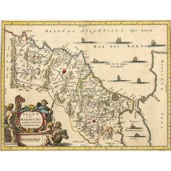
Le Royaume de Maroc. (12).
Scarce map of Morocco published by Antoine de Fer in 1661 or 1662 in "Cartes de géographie revues et augmentées". With number 12 in lower right bottom of the ...
Date: Paris, Antoine de Fer, 1657 but 1661 or 1662
Selling price: ????
Please login to see price!
Sold in 2020
Guinee. (13).
Scarce map of Guinea published by Antoine de Fer in 1661 or 1662 in "Cartes de géographie revues et augmentées". With number 13 in lower right bottom of the m...
Date: Paris, Antoine de Fer, 1657 but 1661 or 1662
Selling price: ????
Please login to see price!
Sold in 2020
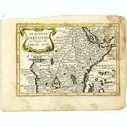
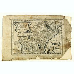
Le royaume d'Abyssinie ou l'Empire du Prete Iean. (14).
Scarce map of Abyssinia and Ethiopia published by Antoine de Fer in 1661 or 1662 in "Cartes de géographie revues et augmentées". With number 14 in lower right...
Date: Paris, Antoine de Fer, 1657 but 1661 or 1662
Selling price: ????
Please login to see price!
Sold in 2020
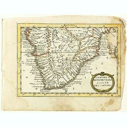
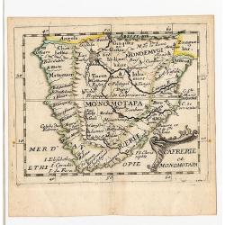
L'Empire du Monomotapa et coste des Caffres. (15).
Scarce map of Southern Africa published by Antoine de Fer in 1661 or 1662 in "Cartes de géographie revues et augmentées". With number 15 in lower right bottom...
Date: Paris, Antoine de Fer, 1657 but 1661 or 1662
Selling price: ????
Please login to see price!
Sold in 2018
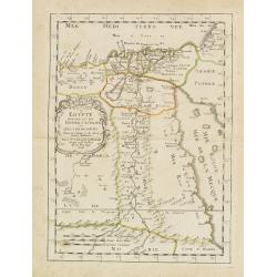
Aegyptus Antiqua Divisa in Nomos Authore P. Duval. . .
A decorative map of ancient Egypt oriented with West at the top. Very detailed map, showing the Nile River, Red Sea, Pyramids, and much more information. Also shows sever...
Date: Amsterdam, ca. 1662
Selling price: ????
Please login to see price!
Sold in 2018
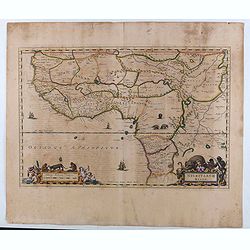
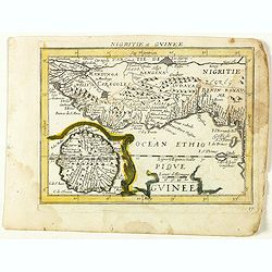
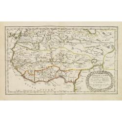
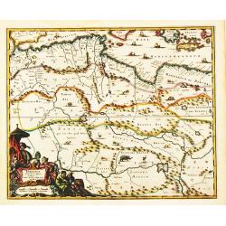
Nigritarum regio.
Blaeu's map of a part of West Africa, from Tropic of Cancer southward including the Senegal River to Angola. The map includes decorative title and scale statement cartouc...
Date: Amsterdam, 1662
Selling price: ????
Please login to see price!
Sold in 2020
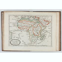
L'Affrique En Plusieurs Cartes Nouvelles, et exactes, &c.
Edition illustrated with 18 maps in original outline colors dated 1656. No date and title page and maps not numbered (according to Pastoureau 1 C, maps are numbered).Nico...
Date: Paris, l'Auteur, after 1662
Selling price: ????
Please login to see price!
Sold in 2026
Africae nova descriptio.
A wide paper copy, probably from his famous Atlas Major. Much of the geographical information is still based on the Ptolemaic maps, with the Nile shown with its source in...
Date: Amsterdam 1663
Selling price: ????
Please login to see price!
Sold
Cafrerie et Monomotapa.
Rare first state, 1663. While this map is generally well known from the 1676 edition, this first state, dated from the title page 1663 is rare. Table Bay isn\'t labeled,...
Date: Paris, 1663
Selling price: ????
Please login to see price!
Sold in 2008
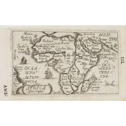
Africa Descriptio.
Charming little map of Africa made by Gabriel Bucelin (1599-1681). Bucelin was a Swiss genealogist and an author of several books and a number of manuscript maps of Germa...
Date: Ulm, Johannes Görlin, 1658-1664
Selling price: ????
Please login to see price!
Sold in 2008
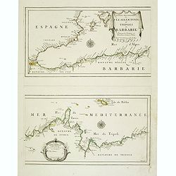
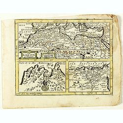
Les Costes Des Royaumes de Fez, Alger, Tunis et Tripoli en Barbarie suivant les Routiers et Portolans de divers Pilotes . . .
Two Uncommon maps on one sheet of the Mediterranean Sea with the coast of North Africa with the kingdoms of Tunis and Tripoli. Including the southeastern coast of Spain w...
Date: Paris, 1664
Selling price: ????
Please login to see price!
Sold in 2020
Hydrophylacium Africae precipuum, in montibus lunae situm.
Rare and Interesting map showing the sources of the Nile in a cavern beneath the Mountains of the Moon. From Kircher's "Mundus Subterranaeus". Top right Tomus I...
Date: Amsterdam, 1665
Selling price: ????
Please login to see price!
Sold in 2020
Hydrophylacium Africae precipuum, in montibus lunae situm.
Rare and Interesting map showing the sources of the Nile in a cavern beneath the Mountains of the Moon. From Kircher's "Mundus Subterranaeus". Top right Tomus ...
Date: Amsterdam, 1665
Selling price: ????
Please login to see price!
Sold in 2022
![Del Mina. St. Iago [with] Carmantyn [with] Cabo Verde ofte t. Eijlant Goeree.](/uploads/cache/48507-250x250.jpg)
Del Mina. St. Iago [with] Carmantyn [with] Cabo Verde ofte t. Eijlant Goeree.
Thee engravings on one sheet. View of Elmina, Cormante and the island of Goeree as happened July 1665. Above: the Dutch fleet under Admiral Michiel de Ruyter with three c...
Date: Amsterdam, 1665
Selling price: ????
Please login to see price!
Sold in 2023
Pas-Caart van Guinea en de Custen daer aen gelegen Van Cabo verde tot Cabo de Bona Esperanca
Beautiful seachart of the southwest coast of Africa by P. Goos from the famous sea atlas "De Zee-Atlas ofte Water-Weereld". Showing the coatlines of Guinea, Sie...
Date: Amsterdam, 1666
Selling price: ????
Please login to see price!
Sold in 2008
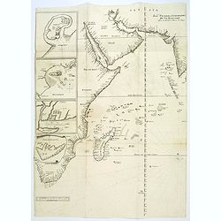
Pascaerte van 't Westelyckste Deel van Oost Indien, van Cabo de Bona Esperanca tot C.Comorin..
An eye-catching of the western part of the Indian Ocean and its adjacent coasts of East Africa, Arabia with the Red Sea and the Arabian Gulf, Iran, Pakistan and western ...
Date: Amsterdam, 1666
Selling price: ????
Please login to see price!
Sold in 2009
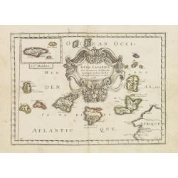
Caarte voor.. Canarise Eylanden als Canaria, Tenerifa..
Very rare chart of the Canaries. Showing Palma, Ferro, Tenerife, Gran Canary, Forte Ventura, Lancelot. In upper right hand corner inset of harbor of Lancerota.Pieter Goos...
Date: Amsterdam, 1666
Selling price: ????
Please login to see price!
Sold in 2017
AFRICÆ Descriptio Nova Impensis PHILIPPI CHETWIND 1666
This map is a close copy of John Speed's map of Africa of 1626 with the placenames and text legends in English. The placement of sailing ships, sea monsters, and even muc...
Date: London, (1652) 1666
Selling price: ????
Please login to see price!
Sold in 2011
Carte de l'Isle Madagascar dite autrement Madecale et de S. Laurens et aujourd'hui l'Isle Dauphine avec les Coste de Cofala et du Mozambique en Afrique . . .
Uncommon map of the island Madagascar with the African coast countries Mozambique and Cofala. Numerous place names, soundings and sand banks are shown round the island an...
Date: Paris, 1666
Selling price: ????
Please login to see price!
Sold in 2013
Pas-Caart van Guinea en de Custen daer aen gelegen Van Cabo verde tot Cabo de Bona Esperanca.
A rare sea chart of the southwest coast of Africa from the Guinea Coast down to the Cape of Good Hope, covering Guinea, Sierra Leone, Liberia, the Ivory Coast, Ghana, Nig...
Date: Amsterdam, 1666
Selling price: ????
Please login to see price!
Sold in 2016
Isle D'Auphine, communement Nommée pae les Europeens Madagascar. . .
Fine map of Madagascar, also showing the Comoros Islands in the North West and the Reunion Island in the South East.With decorative title cartouche representing some nati...
Date: Paris, 1667
Selling price: ????
Please login to see price!
Sold in 2013
Afrique. . .
Map of the African continent prepared by N.Sanson and published by Pierre Mariette.Published in an early edition of the small Sanson atlas L'Europe Dediée a Monseigneur ...
Date: Paris, P. Mariette, 1667
Selling price: ????
Please login to see price!
Sold in 2008
Royaume de Maroc. . .
Map of Morocco prepared by N.Sanson and published by Pierre Mariette.Published in an early edition of the small Sanson atlas L'Europe Dediée a Monseigneur . . . Le Telli...
Date: Paris, P. Mariette, 1667
Selling price: ????
Please login to see price!
Sold in 2012
Egypte divisée en ses douze cassilifs, ou gouvermens. . .
Map of Egypt prepared by N.Sanson and published by Pierre Mariette.Published in an early edition of the small Sanson atlas L'Europe Dediée a Monseigneur . . . Le Tellier...
Date: Paris, P. Mariette, 1667
Selling price: ????
Please login to see price!
Sold in 2013
L'Afrique ou Libie ulterieur ou font le Saara ou desert. . .
Map of Guinea coast prepared by N.Sanson and published by Pierre Mariette.Published in an early edition of the small Sanson atlas L'Europe Dediée a Monseigneur . . . Le ...
Date: Paris, P. Mariette, 1667
Selling price: ????
Please login to see price!
Sold in 2008
Partie de la Haute Aethiopie. . .
Map of Ethiopia prepared by N.Sanson and published by Pierre Mariette.Published in an early edition of the small Sanson atlas L'Europe Dediée a Monseigneur . . . Le Tell...
Date: Paris, P. Mariette, 1667
Selling price: ????
Please login to see price!
Sold in 2008
Isle de Madagascar. . .
Map of Madagascar prepared by N.Sanson and published by Pierre Mariette.Published in an early edition of the small Sanson atlas L'Europe Dediée a Monseigneur . . . Le Te...
Date: Paris, P. Mariette, 1667
Selling price: ????
Please login to see price!
Sold in 2008
Pays et Coste des Caferes: Empres du Monomotapa Monoemugi. . .
Map of Southern Africa prepared by N.Sanson and published by Pierre Mariette.Published in an early edition of the small Sanson atlas L'Europe Dediée a Monseigneur . . . ...
Date: Paris, P. Mariette, 1667
Selling price: ????
Please login to see price!
Sold in 2008
Isle du Cap Verd Coste, et pays des Negres. . .
Depicting the West Coast of North Africa and also showing the Cape Verde Islands prepared by N.Sanson and published by Pierre Mariette.Published in an early edition of th...
Date: Paris, P. Mariette, 1667
Selling price: ????
Please login to see price!
Sold in 2008
Isles Canaries. . .
Map of Canary Islands prepared by N.Sanson and published by Pierre Mariette.Published in an early edition of the small Sanson atlas L'Europe Dediée a Monseigneur . . . L...
Date: Paris, P. Mariette, 1667
Selling price: ????
Please login to see price!
Sold in 2011
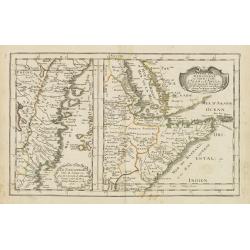
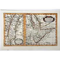
Le Zanguebar Partie du Zanguebar ou sont les Costes d'AJAN et d'ABEX.
Two maps on one sheet showing the coasts of East Africa. The left hand map shows the Zanzibar coast, the right hand map shows the coast north from Zanzibar, round the Hor...
Date: Paris, P. Mariette, 1667
Selling price: ????
Please login to see price!
Sold in 2008
Royaume de Congo & c. . .
Decorative map of the Congo on Africa's west coast.An attractive miniature map prepared by N.Sanson and published by Pierre Mariette.Published in an early edition of the ...
Date: Paris, P. Mariette, 1667
Selling price: ????
Please login to see price!
Sold
Le Royaume de Marroc.
Rare map of Morocco published by Jollain in 1667. Published in "Trésor Des Cartes Geographiques Des Principaux Estats de Lunivers". This atlas is based upon B...
Date: Paris, 1667
Selling price: ????
Please login to see price!
Sold in 2016
Le Royaume de Fez.
Rare map of a part of Morocco published by Jollain in 1667. Published in "Trésor Des Cartes Geographiques Des Principaux Estats de Lunivers". This atlas is ba...
Date: Paris, 1667
Selling price: ????
Please login to see price!
Sold in 2020
Barbarie.
Rare map of the Barbary Coast of Africa, published by Jollain in 1667. Published in "Trésor Des Cartes Geographiques Des Principaux Estats de Lunivers". This ...
Date: Paris, 1667
Selling price: ????
Please login to see price!
Sold in 2019
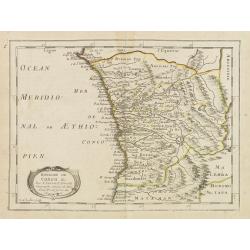
Le Royaume Abyssin ou l'Empire du Presteiean.
Rare map of Central Africa with Ethiopia, published by Jollain in 1667. Published in "Trésor Des Cartes Geographiques Des Principaux Estats de Lunivers".This a...
Date: Paris, 1667
Selling price: ????
Please login to see price!
Sold in 2021
Guinee. (inset) I. S. Thomas.
Rare map of Guinea with inset of I. S. Thomas, published by Jollain in 1667. Published in "Trésor Des Cartes Geographiques Des Principaux Estats de Lunivers".T...
Date: Paris, 1667
Selling price: ????
Please login to see price!
Sold in 2021
Partie du ZANGUEBAR ou Sont les Costes d'AJAN et d' ABEX &c.
Two, maps on one sheet showing the coasts of East Africa. The left hand map shows the Zanzibar coast, the right hand map shows the coast north from Zanzibar, round the Ho...
Date: Paris, P. Mariette, 1667
Selling price: ????
Please login to see price!
Sold in 2019
Insula S. Laurentii, vulgo Madagascar.
Map of the island of Madagascar and coastline of Mozambique. Title and impressum in a nice cartouche with figures and animals at bottom left. Shows also the islands arou...
Date: Amsterdam, 1667
Selling price: ????
Please login to see price!
Sold in 2022
![[Lot of 10 maps / prints of the South Atlantic Ocean islands] CAPEVERDIAN ISLANDS / Insulae Promontorii Viridis.](/uploads/cache/18308-(1)-250x250.jpg)
[Lot of 10 maps / prints of the South Atlantic Ocean islands] CAPEVERDIAN ISLANDS / Insulae Promontorii Viridis.
A map of the Capeverdian islands, embellished with two large and attractive cartouches. With lot of 9 maps / prints of the South Atlantic Ocean islands.
Date: Amsterdam, 1668
Selling price: ????
Please login to see price!
Sold in 2022
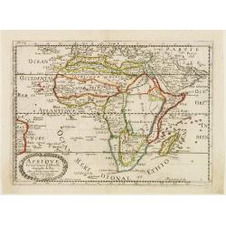
Afrique.
Copper engraved map of Africa that includes Arabia and the Canary and Cape Verde Islands as well as several other Atlantic islands and the coastline of Brazil. Also inclu...
Date: Paris 1669
Selling price: ????
Please login to see price!
Sold
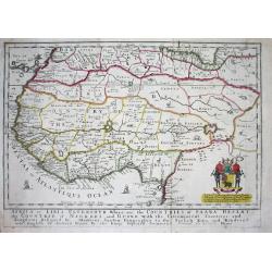
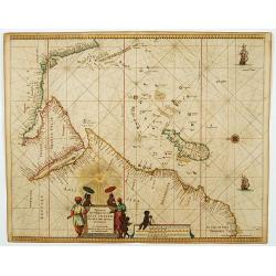
Africa or Libia Ulteriour Where are the Countries of Saara Desert...
Rare map of Western Africa after Sanson. Detailed early Geography with numerous errors of the time. Important mapping of the Canary Islands. The map shows an unusual amou...
Date: London 1669
Selling price: ????
Please login to see price!
Sold
A Mapp of the Higher and Lower Aethiopia Comprehending ye Several Kingdomes ...
The earliest folio sized map of the region to be engraved in England. elaborate heraldic cartouche and a dedication to William Glynne as per Norwich 44. From his Geograph...
Date: London, 1669
Selling price: ????
Please login to see price!
Sold in 2009
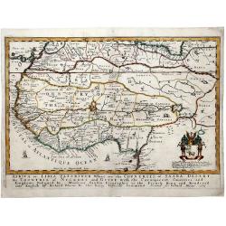
AFRICA or LIBIA ULTERIOUR Where are the COUNTRIES OF SAARA DESERT the COUNTRIE of NEGROES and GUINE.
A map of Western Africa after Sanson. Detailed early geography with numerous errors typical of the time. Important mapping of the Canary Islands. The map shows an unusual...
Date: London, 1669
Selling price: ????
Please login to see price!
Sold in 2019
Aethiopia inferior vel Exterior.
The standard map of South Africa throughout the 17th century covering the region from Congo-Zanzibar to the Cape. Based on the map of Portuguese exploration and most deta...
Date: Amsterdam 1670
Selling price: ????
Please login to see price!
Sold
Insulae de Cabo Verde olim Hesperides sive .. Zoute Eylanden.
A beautiful sea chart of these important islands. The map is a re-issue of the map by J.Janssonius. Beautifully embellished with rhumb lines, compass rose and cartouche.
Date: Amsterdam 1670
Selling price: ????
Please login to see price!
Sold
Africae accurata tabula ex officina Nic. Visscher.
Fine map of the continent of Africa filled with mythical towns, rivers, and mountains and continues to reflect the Ptolemaic view of Africa. A title cartouche in upper ig...
Date: Amsterdam, 1670
Selling price: ????
Please login to see price!
Sold in 2018
Africae nova Tabula Auct. Jud. Hundio.
This very rare map of the African continent contains a dedication to the Marchese Andrea Paleotti and his wife Christine Dudley who was the granddaughter of Sir Robert Du...
Date: Bologna, c. 1670
Selling price: ????
Please login to see price!
Sold in 2017
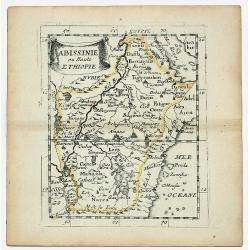
ABISSINIE ou Haute ETHIOPIE.
Nubie old, outlined colored historical miniature map of Abyssinie in north Ethiopia. The map is copperplate engraved with hand coloring and in very good condition and pu...
Date: Paris 1670
Selling price: ????
Please login to see price!
Sold in 2020
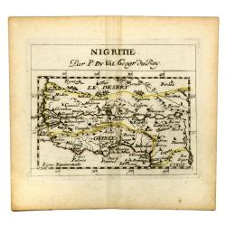
NIGRITIE. Par P. Du VAL Geogr du Roy.
Miniature map of west coast of Africa, showin Guinee, Sahara desert, Congo, Niger, etc.
Date: Paris, c 1670
Selling price: ????
Please login to see price!
Sold in 2020
Fezzae et Marocchi Regna Africae Celeberrima.
A lovely example of John Ogilby's map of Fez and Morocco in north Africa, published in London during the second half of the 17th century. North is orientated to the left,...
Date: London, 1670
Selling price: ????
Please login to see price!
Sold in 2020
Africa Ioanne Baptista Nicolosio?
From: Hercules Siculus Sive Studium Geographicum ? Rome, 1670-71. (Second state).In 1652 the Propaganda Fide commissioned Giovanni Battista Nicolosi (1610-70) to produce ...
Date: Rome, 1671
Selling price: ????
Please login to see price!
Sold in 2010
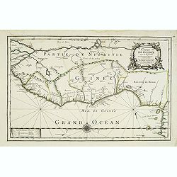
Costes de Guinée avec les Royaumes qui y sont connus des Européens, au-dedans des terres, selonn les relations les plus nouvelles . . .
Uncommon map of the Guinea, with fine title cartouche upper right . Dated 1671 and without the inset map added in 1677.
Date: Paris, 1671
Selling price: ????
Please login to see price!
Sold
Africa (heightened with gold leaf)
From a copy of "Introductionis in Universam Geographicam". Published by Bertius in Amsterdam and printed on the Elzevier press. Beautiful map in period correct ...
Date: Amsterdam, ca. 1672
Selling price: ????
Please login to see price!
Sold
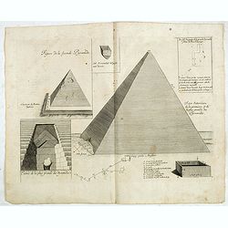
Figure de la seconde Pyramide.
An early print of a pyramid published from 1672 onwards in "Relations de Divers Voyages Curieux" by the French geographer, Melchisédech Thévenot. Thévenot's ...
Date: Paris, 1672
Selling price: ????
Please login to see price!
Sold in 2016
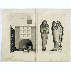
Plan de Caves des mummies.
An early print of mummies in Cairo published from 1672 onwards in "Relations de Divers Voyages Curieux" by the French geographer, Melchisédech Thévenot. Thév...
Date: Paris, 1672
Selling price: ????
Please login to see price!
Sold in 2015
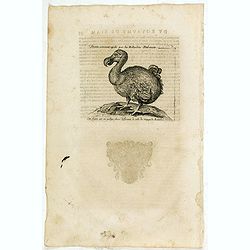
Dronte, autrement appellé par les Hollandois Dod-aers.
An early text engraving of a Dodo who Willem Ysbrandtszoon Bontekoe claimed to have seen on Réunion and published from 1672 onwards in "Relations de Divers Voyages ...
Date: Paris, 1672
Selling price: ????
Please login to see price!
Sold in 2015
Dronte Alijs Dod-Aers.
An early text engraving of a Dodo who Willem Ysbrandtszoon Bontekoe claimed to have seen on Réunion and published from 1672 onwards in "Relations de Divers Voyages ...
Date: Paris, 1672
Selling price: ????
Please login to see price!
Sold in 2015
Joao Teixeira Cosographo de sua Magestade.
An early issue of this important map of the Indian Ocean was prepared by Joao Teixeira, a well-known and respected Portuguese chart maker. He produced this wonderful sea ...
Date: Paris ca. 1672
Selling price: ????
Please login to see price!
Sold in 2017
Fezzae et Marochi.
Decorative map of Morocco based on Blaeu's map of the same title. It is oriented with north on the right and includes the Strait of Gibraltar. The sea is filled with seve...
Date: Amsterdam, 1673
Selling price: ????
Please login to see price!
Sold in 2015
Barbaria, Biledulgerid, Libye et pars Nigritarum terra.
A map from Olfert Dapper's Africa. It depicts Algeria, Tunesia and western Libya. Embellished with a very decorative cartouche.
Date: Amsterdam, 1673
Selling price: ????
Please login to see price!
Sold in 2020
Cimbebas et Caffariae Littora a Catenbela ad Promontorium..
The coast of Angola, South-West Africa and South Africa up to Port Elizabeth. Classic sea chart of Dutch school with excellent baroque embellishment. North oriented to th...
Date: Amsterdam, 1675
Selling price: ????
Please login to see price!
Sold in 2008
