Browse Listings in Africa
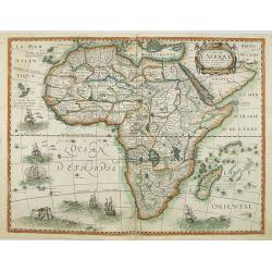
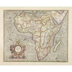
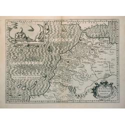
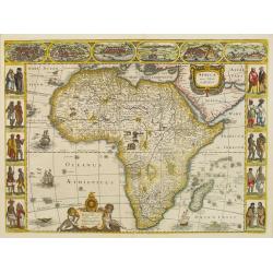
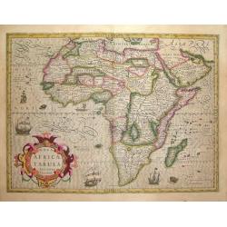
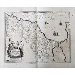
Carte de L'Afrique, corrigée et augmentée desus toutes les autres cy deuant faictes par P.Bertius.
Rare map of Africa, no date. First state, issued by Melchoir Tavernier. Most probably engraved by Cornelis Danckerts (the elder), a highly skilled engraver. Most probably...
Date: Paris, 1627
Selling price: ????
Please login to see price!
Sold in 2019
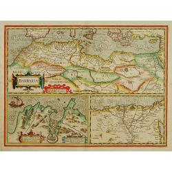
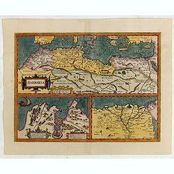
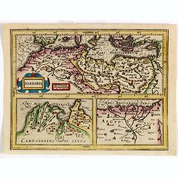
BARBARIA.
With two insets: Map of the Siege of Tunis and map of the Nile Delta.From the tenth edition of the Mercator's Atlas Sive Cosmographicae completed and reissued by Henricus...
Date: Amsterdam 1628
Selling price: ????
Please login to see price!
Sold
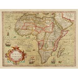
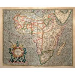
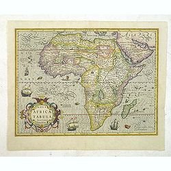
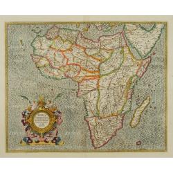
Nova Africae Tabula.
An attractive map of the continent, added by Hondius when he took over publication of Mercator\'s Atlas. Although it is based on Mercator\'s map, Hondius improved the out...
Date: Amsterdam 1628
Selling price: ????
Please login to see price!
Sold
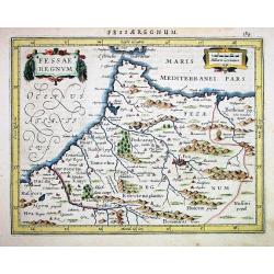
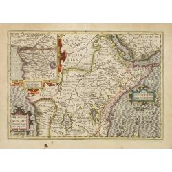
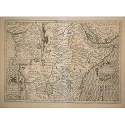
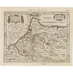
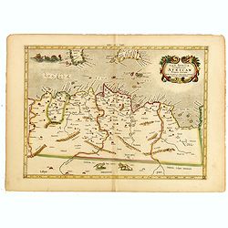
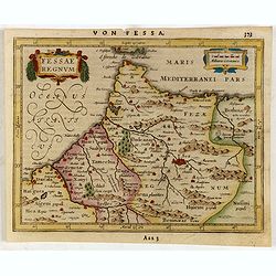
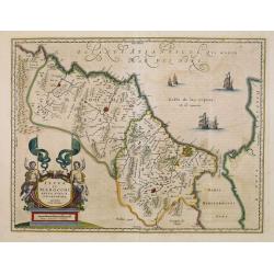
Fessae Regnum
Janssons desirable map of northern Morocco and Gibraltar, engraved for Mercators Atlas Minor. Very detailed with well engraved symbols representing towns, mountains, wood...
Date: Amsterdam 1628
Selling price: ????
Please login to see price!
Sold
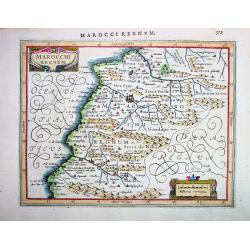
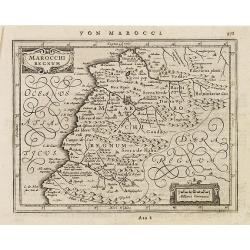
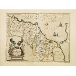
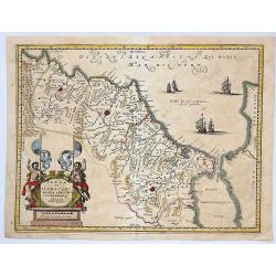
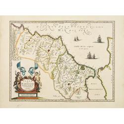
MAROCCHI REGNUM
Janssons desirable map of Morocco and the Atlas Mountains, engraved for Mercators Atlas Minor (page 579). Very detailed with well engraved symbols representing towns, mou...
Date: Amsterdam, 1628
Selling price: ????
Please login to see price!
Sold in 2008
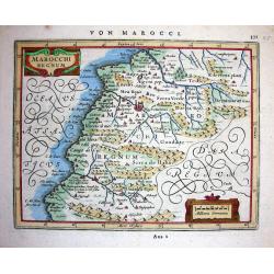
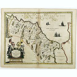
Marocchi Regnum.
Janssons beautiful map of Morocco and the Atlas Mountains, engraved for Mercators Atlas Minor (page 371-A22 2). Very detailed with a lot of topographical information and ...
Date: Amsterdam, 1628
Selling price: ????
Please login to see price!
Sold in 2008
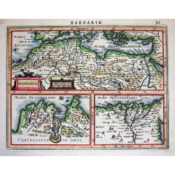
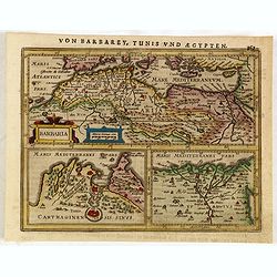
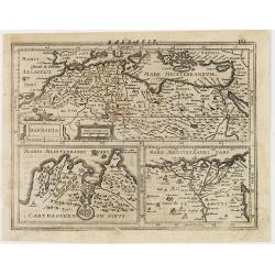
Barbaria.
Excellent map by Jansson, engraved for Mercators Atlas Minor (page 575). The map is divided in three parts: the top part is showing Northern Africa with the Mediterranean...
Date: Amsterdam, c.1628
Selling price: ????
Please login to see price!
Sold
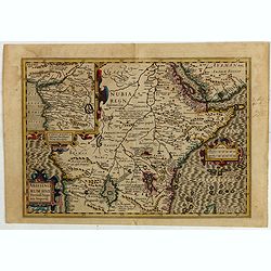
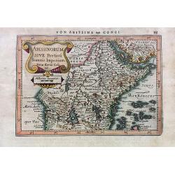
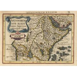
Abissinorum sive Pretiosi Ioannis Imperiu
Hondius' Prester John Map. French text on verso.
Date: Amsterdam, 1628
Selling price: ????
Please login to see price!
Sold in 2010
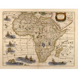
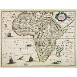
Africa ex magna orbis terre descriptione Gerardi Mercator. . .
Map of Africa, based on Gerard Mercator's twenty-one sheet wall map of the World, first published in 1569. Much of the interior of Africa defers to the traditions of Ptol...
Date: Amsterdam, 1628
Selling price: ????
Please login to see price!
Sold in 2010
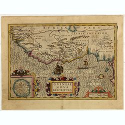
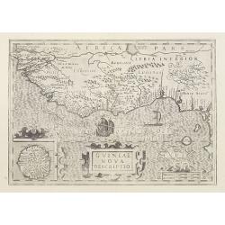
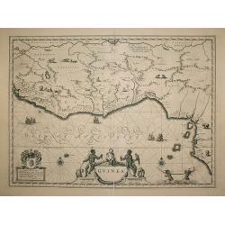
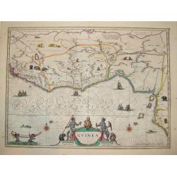
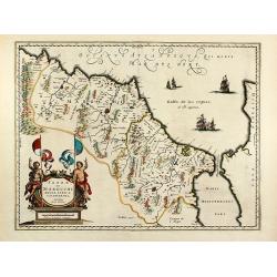
Guineae Nova Descriptio.
The map shows the West African coast from Senegal (the 'Rio Senega' is the Senegal River) to Cape Lopez on the Gulf of Guinea just below the equator.The island of St. Tho...
Date: Amsterdam, 1628
Selling price: ????
Please login to see price!
Sold in 2015
Abissinorum sive Pretiosi Joannis Imperiu.
Despite the title this map extends far beyond Prester John's supposed kingdom. It covers Africa from the fabled mountains of the moon in the center of the continent north...
Date: Amsterdam, 1628
Selling price: ????
Please login to see price!
Sold in 2016
Barbaria. / Carthaginensis sinus / Aegyptus.
With two insets: Map of the Siege of Tunis and map of the Nile Delta.From the tenth edition of the Mercator's Atlas Sive Cosmographicae completed and reissued by Henricus...
Date: Amsterdam, ca.1628
Selling price: ????
Please login to see price!
Sold in 2015
Abissinorum Sive Pretiosi Ioannis Imperium
A single page map of central and eastern Africa. This map depicts the mythical Christian kingdom of 'Prester John' on the African continent. Based on Mercator/ Hondius.
Date: Amsterdam, 1628
Selling price: ????
Please login to see price!
Sold in 2018
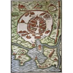
Tunis
Woodcut of the Barbary town Tunis and outside the double walls a Women house (Harem) Botanical Garden (Hortus) an ancient Thermae (Therme). As well as the ruins of Cartha...
Date: Basel, 1628
Selling price: ????
Please login to see price!
Sold in 2020
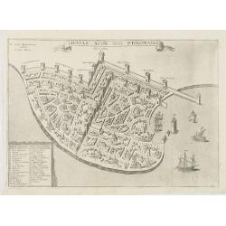
Civitas Acon sive Ptolomaida.
Rare town-plan of Acre, based upon the Vesconte-Sanuto plan, intended to illustrate a period when the town was under the control of the Knights of St. John. Shows extensi...
Date: Paris, Michael Soly, 1629
Selling price: ????
Please login to see price!
Sold in 2013
Nova Africae Tabula.
An attractive map of the continent, added by Hondius when he took over publication of Mercator's Atlas. Although it is based on Mercator's map, Hondius improved the outli...
Date: Amsterdam, 1630
Selling price: ????
Please login to see price!
Sold in 2013
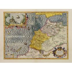
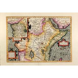
Fessae et Marocchi Regna.
One of the new maps added by Hondius, when he took over publication of the Atlas, a finely engraved and decorative map of north-west Africa, with the Canaries. With an in...
Date: Amsterdam 1630
Selling price: ????
Please login to see price!
Sold
Abissinorum sive Pretiosi Joannis Imperiu.
Despite the title this map extends far beyond Prester John's supposed kingdom. It covers Africa from the fabled mountains of the moon in the center of the continent north...
Date: Amsterdam 1630
Selling price: ????
Please login to see price!
Sold
Guineae Nova Descriptio.
The map shows the West African coast from Senegal (the 'Rio Senega' is the Senegal River) to Cape Lopez on the Gulf of Guinea just below the equator.The island of St. Tho...
Date: Amsterdam, 1630
Selling price: ????
Please login to see price!
Sold
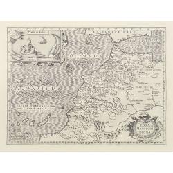
Fessae et Marocchi Regna
Richly embellished map of Morocco with a large inset titled Penon de Velez showing a fort on the Barbary coast. The map includes the Canary islands and Madera.Three strap...
Date: Amsterdam, 1630
Selling price: ????
Please login to see price!
Sold
Abissinorum sive Pretiosi Joannis Imperiu.
Despite the title this map extends far beyond Prester John's supposed kingdom. It covers Africa from the fabled mountains of the moon in the center of the continent north...
Date: Amsterdam, 1630
Selling price: ????
Please login to see price!
Sold
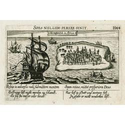
Mombaza in Africa.
Early and important copper engraved view of the former Portugese colony Mombasa on Mombasa Island, in present day Kenya. Showing a large and beautifully illustrated saili...
Date: Frankfurt , c 1630
Selling price: ????
Please login to see price!
Sold in 2011
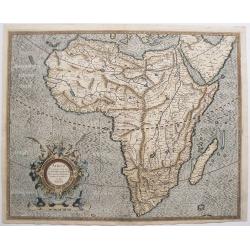
Africa ex magna orbis terre descriptione Gerardi Mercator.
Map of Africa. Much of the interior of Africa defers to the traditions of Ptolemy. The Nile river is shown with the two lakes and the Mountains of the Moon across souther...
Date: Amsterdam, 1630
Selling price: ????
Please login to see price!
Sold in 2016
Abissinorum sive Pretiosi Joannis Imperiu.
Despite the title this map extends far beyond Prester John's supposed kingdom. It covers Africa from the fabled mountains of the moon in the center of the continent north...
Date: Amsterdam, 1630
Selling price: ????
Please login to see price!
Sold in 2010
Fessae et Marocchi Regna.
Richly embellished map of Morocco with a large inset titled Penon de Velez showing a fort on the Barbary coast. The map includes the Canary islands and Madera.Three strap...
Date: Amsterdam, 1630
Selling price: ????
Please login to see price!
Sold in 2010
Africa ex magna orbis terre descriptione Gerardi Mercator. . .
Map of Africa. Much of the interior of Africa defers to the traditions of Ptolemy. The Nile river is shown with the two lakes and the Mountains of the Moon across souther...
Date: Amsterdam, 1630
Selling price: ????
Please login to see price!
Sold in 2015
Fessae regnum.
Nice small map of the northeast tip of Africa with Fez showing as the principal city. Decorative title and distance scale cartouches. German text on verso.
Date: Amsterdam, c. 1630
Selling price: ????
Please login to see price!
Sold in 2010
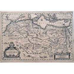
Barbaria
Three maps on one sheet. In upper half a map of North Africa with the Mediterranean and Cyprus. In lower part maps of the region around Tunis and map of the Nile Delta.Fr...
Date: Amsterdam, c. 1630
Selling price: ????
Please login to see price!
Sold in 2011
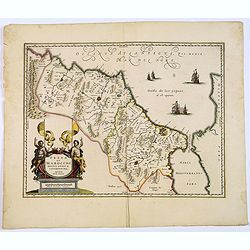
Marocchi Regnum.
A nice map of a part of Morocco with the city Marrakech.
Date: Amsterdam, c.1630
Selling price: ????
Please login to see price!
Sold in 2011
Nova Africae Tabula.
An attractive map of the continent, added by Hondius when he took over publication of Mercator's Atlas. Although it is based on Mercator's map, Hondius improved the outli...
Date: Amsterdam, c.1630
Selling price: ????
Please login to see price!
Sold in 2014
Barbaria.
Charming map of the whole of North Africa and the famed Barbary coast. Two large insets at bottom: Carthaginensis Sinus with the city of Tunis, and a map of the Nile Delt...
Date: Amsterdam, 1630
Selling price: ????
Please login to see price!
Sold in 2015
Tab.II AFRICAE, Complectens AFRICAM Proprie dictam..
Decorative Ptolemaic map of Northern Africa with the southern part of Sardinia and Sicily and Malta. The sea is stipple engraved and contains two very fanciful sea monste...
Date: Amsterdam, 1630
Selling price: ????
Please login to see price!
Sold in 2015
Nova Africae Tabula.
A splendid map of the African continent, heightened in Gold. Added by Hondius when he took over publication of Mercator's Atlas. Although it is based on Mercator's map, H...
Date: Amsterdam, 1630
Selling price: ????
Please login to see price!
Sold in 2019
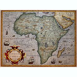
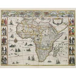
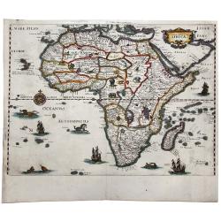
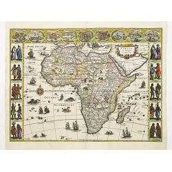
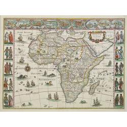
Africae nova Tabula . . .
Africa map from the rare Cloppenburg edition slightly larger format and more scarce edition of the Mercator/Hondius "Atlas Minor". Engraved by Pieter Van Den Ke...
Date: Amsterdam, 1630
Selling price: ????
Please login to see price!
Sold in 2018
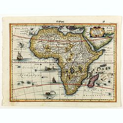
Africae nova Tabula.
Fine map of Africa, it's the issue of Jodocus Hondius map, without the decorative borders. There are six ships in full sail on the Atlantic and one to the south of Madaga...
Date: Amsterdam 1631
Selling price: ????
Please login to see price!
Sold
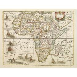
Africae nova Tabula.
Fine map of Africa, it's the issue of Jodocus Hondius map, without the decorative borders. There are six ships in full sail on the Atlantic and one to the south of Madaga...
Date: Amsterdam, 1631
Selling price: ????
Please login to see price!
Sold in 2012
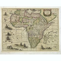
Africae nova Tabula.
Fine "carte à figures"- map of Africa, it's the issue of Jodocus Hondius map, with decorative borders on three sides. There are six ships in full sail on the A...
Date: Amsterdam, 1632
Selling price: ????
Please login to see price!
Sold in 2019
Africa ex magna orbis terre descriptione Gerardi Mercator..
Map of Africa. The cartouche is circular, surrounded by decorative scrolls and surmounted by two satyrs. The beautiful calligraphy is a special feature of Mercator maps. ...
Date: Amsterdam 1633
Selling price: ????
Please login to see price!
Sold
Africae nova tabula
Attractive colored map of Africa. Various animals appear in Africa, sea monsters and fishes in the ocean. It was publish first 1619 by Jodocus Hondius with four decorativ...
Date: 1633
Selling price: ????
Please login to see price!
Sold in 2009
![[Attack of Dutch fleet commanded by Pieter van der Does of Gran Canaria in 1599].](/uploads/cache/40179-250x250.jpg)
[Attack of Dutch fleet commanded by Pieter van der Does of Gran Canaria in 1599].
Attack of Dutch fleet commanded by Pieter van der Does of Gran Canaria in 1599. Scarce print (150x177mm.) on a German text sheet taken from a first edition of Johann Ludw...
Date: Frankfurt, M.Merian, 1633
Selling price: ????
Please login to see price!
Sold in 2025
![[A group of women piercing their hearts with daggers].](/uploads/cache/40182-250x250.jpg)
[A group of women piercing their hearts with daggers].
A group of women piercing their hearts with daggers. Scarce print (150x177mm.) on a German text sheet taken from a first edition of Johann Ludwig Gottfried's "Newe W...
Date: Frankfurt, M.Merian, 1633
Selling price: ????
Please login to see price!
Sold in 2023
![[Dutch fleet attacking Spanish fortess of Gratiosa on Gran Canaria].](/uploads/cache/39914-250x250.jpg)
[Dutch fleet attacking Spanish fortess of Gratiosa on Gran Canaria].
Scarce print with a German text sheet showing a fierce battle taking place between Spanish and Dutch forces. From de Bry's "Great American Voyages". Johann Theo...
Date: Frankfurt, M.Merian, 1633
Selling price: ????
Please login to see price!
Sold in 2018
Abissinorum..
Nice map engraved by Petrus Kaerius. It depicts the kingdom of the fabled Christian king Prester John, with his fortified kingdom shown on a mountain. The Nile River eman...
Date: Amsterdam 1634
Selling price: ????
Please login to see price!
Sold
Fessae Regnum.
Charming small map of the northeast tip of Africa with Fez showing as the principal city. Decorative title and distance scale cartouches.
Date: Amsterdam, 1634
Selling price: ????
Please login to see price!
Sold in 2015
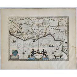
Guinea.
An attractive map, covering the coast from Sierra Leone to Gabon, filed with intersecting rhumb lines and decorated with monkeys, lions, elephants, sea monsters and two c...
Date: Amsterdam, 1635
Selling price: ????
Please login to see price!
Sold in 2009
Africae nova descriptio.
Much of the geographical information is still based on the Ptolemaic maps, with the Nile shown with its source in the Lakes Zaire and Zaflan. Also included are various ot...
Date: Amsterdam, 1635
Selling price: ????
Please login to see price!
Sold in 2010
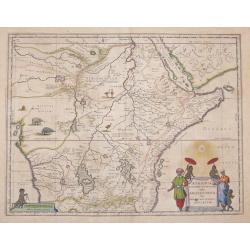
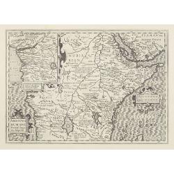
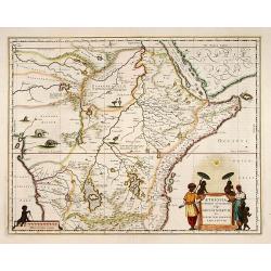
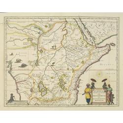
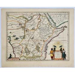
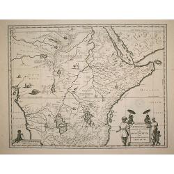
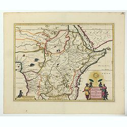
Aethiopia Superior vel Interior vulgo Abissinorum.
An attractive map of Eastern African and the fictitious kingdom of Prester John, issued by Willem Janszoon Blaeu in 1635.The map shows a major section of central and eas...
Date: Amsterdam 1635
Selling price: ????
Please login to see price!
Sold in 2016
Nova Africae Tabula, Auctore Jodoco Hondio
A beautiful map of Africa from the prestigeous Hondius company.This map is from one of the great Hondius/Mercator atlases of the early 17th century. Jodocus Hondius (1563...
Date: Amsterdam, c 1636
Selling price: ????
Please login to see price!
Sold
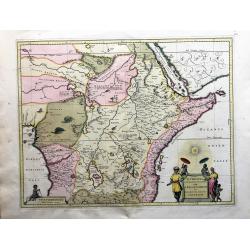
Aethiopia Superior vel Interior; vulgo Abissinorum.
An attractive map of the Eastern African and the fictitious kingdom of Prester John. The map shows a major section of central and eastern Africa including Mozambique nort...
Date: Amsterdam 1638
Selling price: ????
Please login to see price!
Sold
Fezzae et Marocchi regna Africae celeberrima.
North to the right. A finely engraved, decorative map, who influenced subsequent maps for the rest of the century.
Date: Amsterdam 1638
Selling price: ????
Please login to see price!
Sold
Fezzae et Marocchi regna Africae celeberrima.
North to the right. A finely engraved, decorative map, who influenced subsequent maps for the rest of the century.
Date: Amsterdam, 1638
Selling price: ????
Please login to see price!
Sold in 2009
Aethiopia Superior vel Interior vulgo Abissinorum.
An attractive map of the Eastern African and the fictitious kingdom of Prester John. The map shows a major section of central and eastern Africa including Mozambique nort...
Date: Amsterdam, 1638
Selling price: ????
Please login to see price!
Sold in 2014
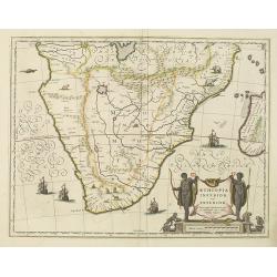
Aethiopia inferior, vel exterior.
The standard map of South Africa throughout the 17th century. The lake out of which the 'Zambere' -the Zambesi- flows is probably based on reports of Lake Ngami, undiscov...
Date: Amsterdam, 1638
Selling price: ????
Please login to see price!
Sold
Fezzae et Marocchi regna Africae celeberrima.
North to the right. A finely engraved, decorative map, who influenced subsequent maps for the rest of the century.As Willem Blaeu died in 1638 most of his maps are actual...
Date: Amsterdam, 1638
Selling price: ????
Please login to see price!
Sold in 2016
Fezzae et Marocchi regna Africae celeberrima.
North to the right. Showing the Atlas Mountains in the south to the southern coast of Spain, along the coast at Ceuta, Tangiers, and Arzilla.A finely engraved, decorative...
Date: Amsterdam, 1638
Selling price: ????
Please login to see price!
Sold in 2015
Nova Barbariae Descriptio
Fantastic and highly decorative map of North Africa covers from Morocco to the Nile delta, and large parts of the Mediterranean from Portugal to Cyprus. Africa is filled ...
Date: Amsterdam, ca. 1638
Selling price: ????
Please login to see price!
Sold in 2016
Fezzae et Marocchi regna Africae celeberrima.
A finely engraved, decorative map of Fez and Morocco by Blaeu, who cartography greatly influenced subsequent maps for the rest of the century. North is orientated to the ...
Date: Amsterdam, 1638
Selling price: ????
Please login to see price!
Sold in 2017
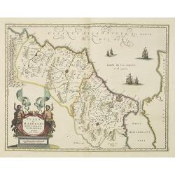
Fezzae et Marocchi Regna Africae Celeberrima.
A fine and detailed map of Morocco showing the large fortified towns of Marakesh, Taradante and Fez. A large decorative cartouche depicts two Centaurs holding flags, and ...
Date: Amsterdam, 1638
Selling price: ????
Please login to see price!
Sold in 2019
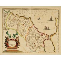
Fezzae et Marocchi regna Africae celeberrima.
An attractive map of northwest Africa and Morocco. The Pillars of Hercules & Straits of Gibraltar, and Spain are shown to the right of the map (north is to the right ...
Date: Amsterdam, 1638
Selling price: ????
Please login to see price!
Sold in 2018
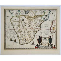
Aethiopia inferior, vel exterior. 

The standard map of South Africa throughout the 17th century. The lake out of which the 'Zambere' - the Zambesi flows is probably based on reports of Lake Ngami, undiscov...
Date: Amsterdam, 1638
Selling price: ????
Please login to see price!
Sold in 2019
Aethiopia Superior vel Interior; vulgo Abissinorum. 

An attractive map of the Eastern African and the fictitious kingdom of 'Prester John'. The map shows a major section of central and eastern Africa including Mozambique no...
Date: Amsterdam, 1638
Selling price: ????
Please login to see price!
Sold in 2019
Guinea.
A detailed and decorative map of Guinea, showing the length of a coast important to African-European trade, including the slave trade. Embellished with numerous animals i...
Date: Amsterdam, 1638
Selling price: ????
Please login to see price!
Sold in 2019
Nova Description AFRICAE.
A decorative example of Merian's map of Africa. This map is richly embellished with animals, including elephants, monkeys, ostriches, gazelles, lions, cheetahs and camels...
Date: Frankfurt, ca 1638
Selling price: ????
Please login to see price!
Sold in 2020
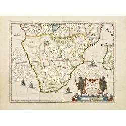
Aethiopia inferior, vel exterior.
The standard map of South Africa throughout the 17th century. The lake out of which the 'Zambere' -the Zambesi- flows is probably based on reports of Lake Ngami, undiscov...
Date: Amsterdam 1640
Selling price: ????
Please login to see price!
Sold
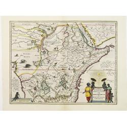
Aethiopia Superior vel Interior vulgo Abissinorum.
An attractive map of the Eastern African and the fictitious kingdom of Prester John. The map shows a major section of central and eastern Africa including Mozambique nort...
Date: Amsterdam 1640
Selling price: ????
Please login to see price!
Sold
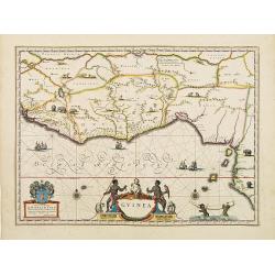
Guinea.
An attractive map covered with intersecting rhumb lines and decorated with monkeys, lions, elephants and native figures. With a dedication to Dr. Nicolas Tulp.
Date: Amsterdam 1640
Selling price: ????
Please login to see price!
Sold
Africae nova descriptio.
Much of the geographical information is still based on the Ptolemaic maps, with the Nile shown with its source in the Lakes Zaire and Zaflan. Also included are various ot...
Date: Amsterdam 1640
Selling price: ????
Please login to see price!
Sold
Guinea.
One of the most beautiful and graphic maps to be found, covering the east coast of Africa from Sierrra Leone to Gabon. The interior is decorated with many wild animals, s...
Date: Amsterdam, ca. 1640
Selling price: ????
Please login to see price!
Sold in 2008
Fezzae et Marocchi regna Africae celeberrima.
An attractive map of northwest Africa and Morocco. The Pillars of Hercules & Straits of Gibraltar, and Spain are shown to the right of the map (north is to the right ...
Date: Amsterdam, 1640
Selling price: ????
Please login to see price!
Sold
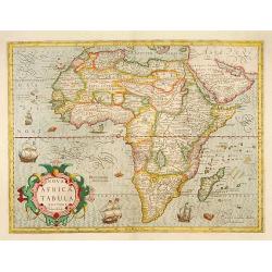
Carte de l' Afrique. . .
Very rare map of Africa.Prepared by P.Bertius and published by Michel van Lochem (1601-47). He was engraver and royal printer, active at "Rue St.Jacques à la Rose B...
Date: Paris, 1640
Selling price: ????
Please login to see price!
Sold in 2008
Africae nova descriptio.
Fine "carte à figures"- map of the continent of Africa. Much of the geographical information is still based on the Ptolemaic maps, with the Nile shown with its...
Date: Amsterdam, 1640
Selling price: ????
Please login to see price!
Sold in 2012
Aethiopia Superior vel Interior vulgo Abissinorum.
An attractive map of the Eastern African and the fictitious kingdom of Prester John. The map shows a major section of central and eastern Africa including Mozambique nort...
Date: Amsterdam, 1640
Selling price: ????
Please login to see price!
Sold in 2009
Abissinorum sive Pretiosi Ioannis Imperiu
Hand colored map of Central Africa by G. Mercator. With two beautiful colored cartouche and one inset map of the Congo. Showing the Kingdom of Prester John in central Afr...
Date: Amsterdam, 1640
Selling price: ????
Please login to see price!
Sold in 2013
Fezzae et Marocchi regna Africae celeberrima
Old colored map of Morocco by W. Blaeu. With the Strait of Gibraltar, several sailing ships and a large figural cartouche. The map is based on Ortelius map of 1570. From ...
Date: Amsterdam, 1640
Selling price: ????
Please login to see price!
Sold in 2009
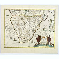
Aethopia Inferior vel Exterior.
A very attractive map of southern Africa depicting the area just prior to the settlement of the Cape Province by the Dutch. The area shown is from the Congo River basin a...
Date: Amstrdam, ca 1640
Selling price: ????
Please login to see price!
Sold in 2019
Fezzae et Marocchi Regna Africae Celeberrima, describebat Arab. Ortelius.
A detailed map of Morocco, oriented with north on the right. Showss Morocco, the Kingdom of Fez, the Atlas Mountains, and the coast of Spain. The Strait of Gibraltar is a...
Date: Amsterdam, ca. 1640
Selling price: ????
Please login to see price!
Sold in 2019
![Carte de L'Afrique Corrigee, et augmentee dessus toutes les aultres cy devant faictes par P. Bertius 1640.[Tavernier]](/uploads/cache/84448-250x250.jpg)
Carte de L'Afrique Corrigee, et augmentee dessus toutes les aultres cy devant faictes par P. Bertius 1640.[Tavernier]
Scarce separately published map of Africa, first published by Melchior Tavernier in Paris in 1627.Bertius's map of Africa is one of the earliest maps of Africa engraved i...
Date: Paris, 1640
Selling price: ????
Please login to see price!
Sold in 2020
Aethiopia Superior vel Interior vulgo Abissinorum.
An attractive map of the Eastern African and the fictitious kingdom of Prester John. The map shows a major section of central and eastern Africa including Mozambique nort...
Date: Amsterdam, ca 1640
Selling price: ????
Please login to see price!
Sold in 2022
Aethiopia Superior vel Interior vulgo Abissinorum...
Offered is a large, decorative, attractive map of Eastern African and the fictitious kingdom of Prester John. The map shows a major section of central and eastern Africa,...
Date: Amsterdam, 1640
Selling price: ????
Please login to see price!
Sold in 2023
Barbaria./ Egypt/ Tunesia.
Three maps on one sheet. Upper part, it shows the coast of Barbaria from Morocco to Egypt: the map on the left corner of Tunis includes a plan of Goletiae, and the right ...
Date: Amsterdam, 1641
Selling price: ????
Please login to see price!
Sold in 2015
