Browse Listings in Africa
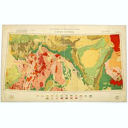
Carte géologique du Nord-Ouest del'Afrique SAHARA CENTRAL.
Geological map showing the Sahara and made by M.Lelubre, R.Karpoff, J.Follot, P.Bordet, A.Cornet, M.Dalloni, etc. Printed by Dufrenoy of Paris.Published by "Comité ...
Date: Paris, c. 1952
Selling price: ????
Please login to see price!
Sold in 2017
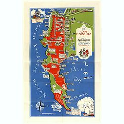
A Map of the Cape Peninsula. Issued by the Cape Peninsula Publicity Association Adderley Street Cape Town South Africa.
Beautiful pictorial map of the Cape Peninsula South Africa shows, its neighbourhood's, green spaces, and historic points of interest. Drawn by Stuart Boyle and published ...
Date: Cape Town, 1952
Selling price: ????
Please login to see price!
Sold in 2018
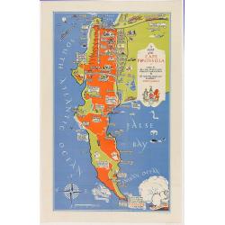
A Map of the Cape Peninsula. Issued by the Cape Peninsula Publicity Association Adderley Street Cape Town South Africa.
Beautiful pictorial map of the Cape Peninsula South Africa shows, its neighborhood's, green spaces, and historic points of interest. Drawn by Stuart Boyle and published b...
Date: Cape Town, 1952
Selling price: ????
Please login to see price!
Sold in 2020
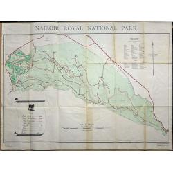
Nairobi Royal National Park.
A large plan of Nairobi National Park, first edition September 1956. A key shows the physical make up of the park plus a list of Mammals and Reptiles found in the park.
Date: Nairobi, 1956
Selling price: ????
Please login to see price!
Sold in 2019
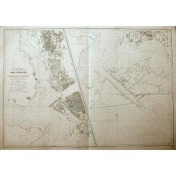
Port d'Abidjan.
An unusual sea-chart of Abidjan, Côte d'Ivoire. With excellent detail of the coasts, and the city. The left chart shows the harbour, and the chart on the right shows the...
Date: Paris, 1965
Selling price: ????
Please login to see price!
Sold in 2018
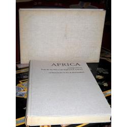
Africa on maps dating from the twelfth to the eighteenth century. Africa auf Karten des 12. bis 18. Jahrhunderts.
First edition. Cloth over Boards. First edition. Elephant folio. The book contains Seventy-seven reproductions of maps of Africa from European map collections, with maps ...
Date: Leipzig, 1968
Selling price: ????
Please login to see price!
Sold in 2017
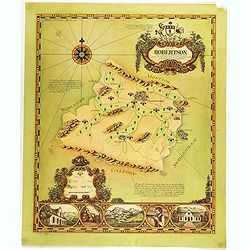
A map of Robertson area as defined for the production of wines of origins . . .
Decorative map of Robertson, a wine area in South Africa. The Cape winelands stretch from the rugged mountains and multi-directional slopes of the coastal region to the o...
Date: South Africa, 1973
Selling price: ????
Please login to see price!
Sold in 2019
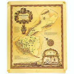
A map of the Worcester area as defined for the production of wines of origin . . .
Decorative map of Worcester, a wine area in South Africa. The Cape winelands stretch from the rugged mountains and multi-directional slopes of the coastal region to the o...
Date: South Africa, 1973
Selling price: ????
Please login to see price!
Sold in 2019
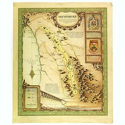
A map of the Olifantsrivier area as defined for the production of wines of origin . . .
Decorative map of Olifantsrivier, a wine area in South Africa. The Cape winelands stretch from the rugged mountains and multi-directional slopes of the coastal region to ...
Date: South Africa, 1973
Selling price: ????
Please login to see price!
Sold in 2019
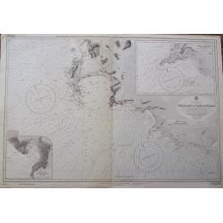
Table Bay to Cape Agulhas.
A large scale Admiralty sea-chart of Cape Town, extending until Struis Bay. With excellent detail of the coasts, including depth soundings. With two insets of Point Dange...
Date: London, 1973
Selling price: ????
Please login to see price!
Sold in 2018
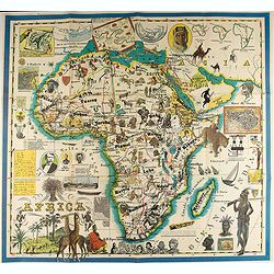
Africa.
A pictorial map of Africa.
Date: Italy, 1986
Selling price: ????
Please login to see price!
Sold in 2020
