Browse Listings in Africa > North Africa
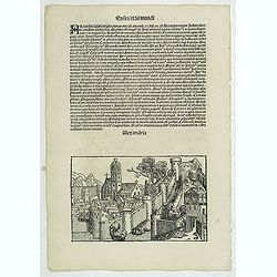
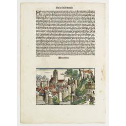
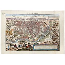
Quita Etas Mundi. Folium. LXXVII.
The Latin text page is illustrated with a depictions of Kings, Noble men and women and scientists. VERSO : A imaginary of Alexandria: however the earliest obtainable vie...
Date: Nuremberg, 12 July 1493
Selling price: ????
Please login to see price!
Sold in 2013
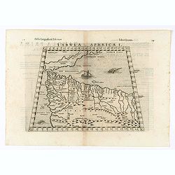
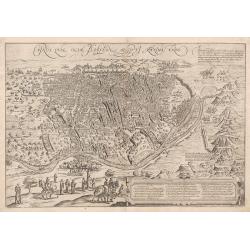
Carthage, etc.
Third-page woodcut from the famous Liber chronicarum or Nuremberg Chronicle of Hartmann-Schedel 1493, the first and Latin edition of this famous and profusely illustrated...
Date: Nuremberg 12 July 1493
Selling price: ????
Please login to see price!
Sold in 2020
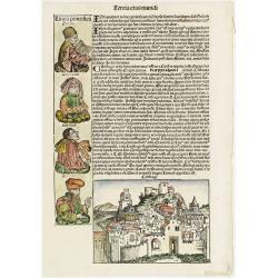
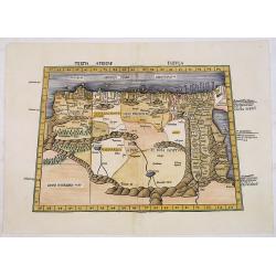
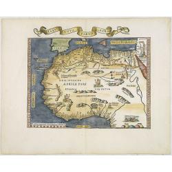
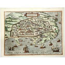
Tercia Etas Mundi. / Carthago (Carthage in Tunisia). / Folio XL.
A very fine presentation of the city of Carthage in Tunisia, centered on the church. (Dim. H : 120 mm W : 168 mm). Including also a genealogy of Zaraya, Meraioth , Amarie...
Date: Nuremberg, 12 July 1493
Selling price: ????
Please login to see price!
Sold in 2019
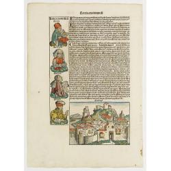
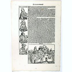
Tercia Etas Mundi. / Carthago. / Folio XL.
A very fine presentation of the city of Carthage, centered on the church.(Dim. H : 120 mm W : 168 mm). Ancient Carthage was the Phoenician city-state of Carthage. During ...
Date: Nuremberg, 12 July 1493
Selling price: ????
Please login to see price!
Sold in 2020
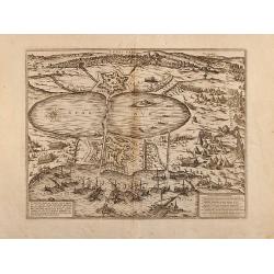
![Sexta Etas Mudi. CCX. Sexta etas mund]. [ With view of Dumyat ]](/uploads/cache/26482-250x250.jpg)
Sexta Etas Mudi. CCX. Sexta etas mund]. [ With view of Dumyat ]
Verso : An imaginary view of Dumyat (Damieta) in Egypt. Dumyat is located on the Nile delta on the Damietta branch of the Nile, close to the Mediterranean Sea.On recto a ...
Date: Nuremberg, 12 July 1493
Selling price: ????
Please login to see price!
Sold in 2018
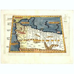
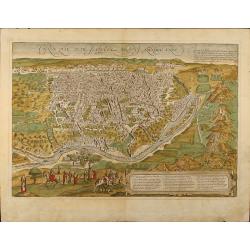
Alexandria. Foliu LXXVII
A imaginary view of Alexandria: however the earliest obtainable view of this period.Page from the Nuremberg Chronicle, published the year that Columbus returned to Europe...
Date: Nuremberg, 12 July 1493
Selling price: ????
Please login to see price!
Sold in 2020

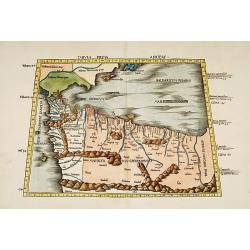
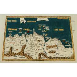
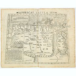
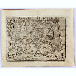
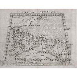
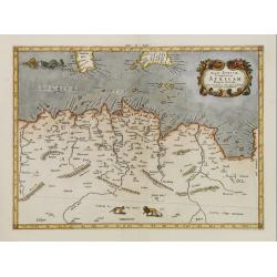
Tertia Africae Tabula.
Early woodcut map of North Africa from M. Waldseemuller of 1513 (1520). Showing the region from Bengazi in Libya up to Egypt with the Red Sea.This ptolemaic map comes fro...
Date: Strasbourg, 1513
Selling price: ????
Please login to see price!
Sold in 2011
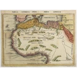
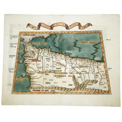
Tabula Moderna Prime partis aphricae.
From Martin Waldseemüller's edition of Ptolemy's Geography , often considered to be the first modern atlas. This is the first printed modern map of North and West Africa ...
Date: Strassburg, 1513
Selling price: ????
Please login to see price!
Sold in 2011
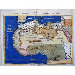
Tabula Moderna Prime partis aphricae.
This maps belongs to the famous 1513, Martin Waldseemüller's, edition of Ptolemy's Geography, which is often considered to be the first modern printed atlas. It is very i...
Date: Strassburg, 1513
Selling price: ????
Please login to see price!
Sold in 2017
Tertia Africae Tabula (North Africa)
Wood block printed large-format Ptolemaic map showing Northeastern Africa, extending from Egypt and the Red Sea (Sinus Arabicus) to Libya. Showing an interesting Nile sys...
Date: Strasburg, 1513
Selling price: ????
Please login to see price!
Sold
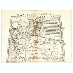
Tabula prima Africae.
One of the earliest maps of Morocco and the northern coast of Africa, including the Balearic islands.From the 1513 Strasburg edition of Ptolemy's Geographia , generally c...
Date: Strasbourg, 1513-1520
Selling price: ????
Please login to see price!
Sold
Tertia Africae Tabula.
Early woodcut map of North Africa from M. Waldseemüller of 1513 (1520). Showing the region from Bengazi in Libya up to Egypt with the Red Sea.From Waldseemüller's Ptolema...
Date: Strasbourg, Johannes Schott, 1513-1520
Selling price: ????
Please login to see price!
Sold in 2016
TABULA PRIMA APHRICE.
An engraved map of Africa from the blocks of Laurent Fries, the famous physician, astrologer and geographer. The map covers northwestern Africa showing the regions that w...
Date: Strasbourg, 1525
Selling price: ????
Please login to see price!
Sold in 2019
![LIBYAE INTERIORI PARS. [Egypt & Libya]](/uploads/cache/82607-250x250.jpg)
LIBYAE INTERIORI PARS. [Egypt & Libya]
A rare 1525 edition of Lorenz Fries's woodcut map of the central part of the North African coastline, with islands in the Mediterranean, based upon the work of Waldseemul...
Date: Strasbourg, 1525
Selling price: ????
Please login to see price!
Sold in 2019
![TABULA II MODERNA APHRICE.[Malta]](/uploads/cache/82606-250x250.jpg)
TABULA II MODERNA APHRICE.[Malta]
A rare 1525 edition of Lorenz Fries's woodcut map of the central part of the North African coastline, with islands in the Mediterranean, based upon the work of Waldseemul...
Date: Strasbourg, 1525
Selling price: ????
Please login to see price!
Sold in 2019
![[North Africa with Egypt] Tabula III. Aphricae. Hae Sunt E Cognitis Totius Orbis . . . (title on verso)](/uploads/cache/42943-250x250.jpg)
[North Africa with Egypt] Tabula III. Aphricae. Hae Sunt E Cognitis Totius Orbis . . . (title on verso)
One of the earliest obtainable maps of North Africa, with Egypt, from Lorenz Fries' (1490-1532) edition of Ptolemy's Geographia, largely based on the 1513 map by Waldseem...
Date: Vienna, 1522, 1535
Selling price: ????
Please login to see price!
Sold in 2019
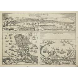
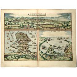
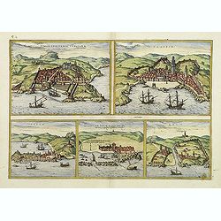
Tunes Oppidum Barbarie & Regina fedes ... / Africa olim Aphrodisum. / Penon de Veles.
Three town-views on one sheet: Tunis, Mahdia and Penon de Veles.The Civitates was compiled and written by George Braun, Canon of Cologne Cathedral. Braun gathered togethe...
Date: Cologne, 1535
Selling price: ????
Please login to see price!
Sold in 2011
Tabula I Aphricae.
Trapezoidal Ptolemaic woodcut map by Laurent Fries features the northwest corner of Africa, which is often referred to as the Maghreb (meaning western in Arabic), and inc...
Date: Vienna, 1522- 1535
Selling price: ????
Please login to see price!
Sold in 2019
Tabu nova partis Aphri. (North Africa)
Based on Waldseemuller's map. Border and ornament are by Hans Holbein and Graf. The maps show Northern Africa as it was known to Europeans at the first part of the 16th c...
Date: Lyons, M. Servetus, 1535
Selling price: ????
Please login to see price!
Sold in 2011
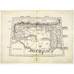
Aphricae tabula secunda continet.
Map representing northern Africa.The fourth edition of Ptolemy's Geographia utilising Lorenz Fries's woodcut maps was published in Vienne, Dauphine, in 1541 by Gaspar Tre...
Date: Vienna, 1541
Selling price: ????
Please login to see price!
Sold
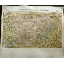
Cairo, Warhaffte abcontrafehtung der machtigen und vesten Statt Alkair.
A highly detailed birds-eye view of the city of Cairo, illustrated with drilling soldiers, crocodiles, camels, horse riding, fishermen at work, mosques, and more. The vie...
Date: Basel, 1544
Selling price: ????
Please login to see price!
Sold in 2019
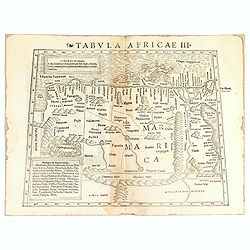
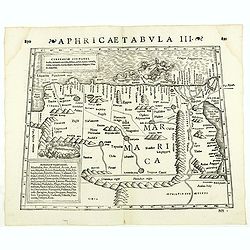
Tabula Africae III.
One of the earliest maps of Egypt, first published in the 1540 edition of Münster's Geographia and reprinted for subsequent editions of the Geographia and Cosmographia. I...
Date: Basel, Heinrich Petri, 1545
Selling price: ????
Please login to see price!
Sold in 2016
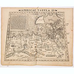
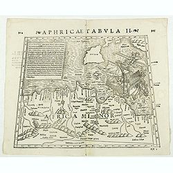
Aphricae Tabula II (Northern Africa and the Mediterranean showing parts of Sicily, Tunisia and Libya.)
The first edition of Munster's map of Northern Africa and the Mediterranean showing parts of Sicily, Tunisia and Libya, based upon Claudius Ptolemy which appeared in his ...
Date: Basel, Heinrich Petri, 1545
Selling price: ????
Please login to see price!
Sold in 2014
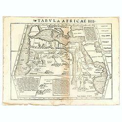
Tabula Africae IIII.
Uncommon first edition of one of the earliest maps of Egypt.Girolamo Ruscelli's edition of Ptolemy's Geographia included newly engraved copperplates by Giulio and Livio S...
Date: Basel, Heinrich Petri, 1545
Selling price: ????
Please login to see price!
Sold in 2016
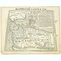
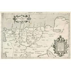
Aphricae Tabula I (Mauritania - present-day Morocco, Algeria, and Tunisia.)
The first edition of Munster's map of Mauritania - present-day Morocco, Algeria, and Tunisia, based upon Claudius Ptolemy which appeared in his "Geographia Universal...
Date: Basel, Heinrich Petri, 1545
Selling price: ????
Please login to see price!
Sold in 2019
Aphricae Tabula III (Northern Africa and the Mediterranean, including Egypt.)
The first edition of Munster's map of Northern Africa and the Mediterranean, including Egypt, based upon Claudius Ptolemy which appeared in his "Geographia Universal...
Date: Basel, Heinrich Petri, 1545
Selling price: ????
Please login to see price!
Sold in 2014
Aphricae Tabula III (Northern Africa and the Mediterranean, including Egypt.)
The first edition of Munster's map of Northern Africa and the Mediterranean, including Egypt, based upon Claudius Ptolemy which appeared in his "Geographia Universal...
Date: Basel, Heinrich Petri, 1545
Selling price: ????
Please login to see price!
Sold in 2020
Aphricae Tabula I (Mauritania - present-day Morocco, Algeria, and Tunisia.)
The first edition of Münster's map of Mauritania - present-day Morocco, Algeria, and Tunisia, based upon Claudius Ptolemy which appeared in his "Geographia Universal...
Date: Basel, Heinrich Petri, 1545
Selling price: ????
Please login to see price!
Sold in 2018
Tabula Aphricae I. (Morocco & Southeast Spain)
Gastaldi's map of North Africa with Morocco and the Balearic Islands to the Pillars of Hercules. Based upon Ptolemy.Embellished is a sailing ship, sea monster and several...
Date: Venice, 1548
Selling price: ????
Please login to see price!
Sold in 2023
Tabula Aphricae II.
Gastaldi's map of North Africa and part of the Mediterranean, including Malta, Sardinia and Sicily. Embellished with two mythical birds and a ship wreck off the coast. Ba...
Date: Venice, 1548
Selling price: ????
Please login to see price!
Sold in 2022
![[Lot of 25 leaves of Africa and Egypt]](/uploads/cache/48275-250x250.jpg)
[Lot of 25 leaves of Africa and Egypt]
Twenty-five text leaves with wood block illustrations relating to Africa and Egypt illustrated with maps, animals, plants.... From the 1552 Latin text edition of Münster'...
Date: Basel, 1552
Selling price: ????
Please login to see price!
Sold in 2025
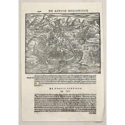
De Africae Regionibus.
A very early Münster wood cut view of Algiers, showing its attempted storming during the Algiers Expedition.Sebastian Münster (1488-1552), was a famous German cartographe...
Date: Basel, 1558
Selling price: ????
Please login to see price!
Sold in 2018
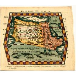
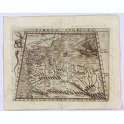
Sinus Arabicus (North Africa)
Woodcut from P. Mela's "De Orbis Situ Libri tres". Published by Henric Perti. Almost a decade after the death of Sebastian Münster, his publisher and stepson He...
Date: Basle, 1561
Selling price: ????
Please login to see price!
Sold in 2021
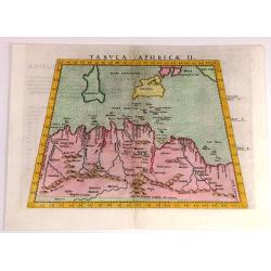
Tabula Aphricae II
Fine Ptolemaic style map of North Africa and including Sardinia, Sicily and the southern tip of Italy. It was published in 1562.
Date: Venice, 1562
Selling price: ????
Please login to see price!
Sold in 2017
Tabula Aphricae I.
Early map of north-west Africa. Girolamo Ruscelli first published the map in his "La Geographi di Claudio Tolomeo" (Venice, 1561). In 1574 a new plate was used ...
Date: Venice, 1564
Selling price: ????
Please login to see price!
Sold in 2020
NVOVA, ET / COPIOSA, DE= / SCRITTIONE / DI TVTTO / L'EGITTO / Pur hora da Paulo / Forlani Veronese / intagliata. in / Venetia l'anno / 1566.
Rare map of the northern part of Egypt. In the right-hand part of the Red Sea. The first of only two "Lafreiri-school" maps made of Egypt!North to the top.Engra...
Date: Venice 1566
Selling price: ????
Please login to see price!
Sold
![[Tripoli] Il vero disegno del porto,della citta, della fortezza, et del sito doue e posta Tripoli di Barbaria.](/uploads/cache/16895-250x250.jpg)
[Tripoli] Il vero disegno del porto,della citta, della fortezza, et del sito doue e posta Tripoli di Barbaria.
Extremely rare map of the environs of Tripoli with a fortification plan of Tripoli in the center. Extensive shipping in the sea.The print is addressed and dated Ven.l'an...
Date: Venice 1568
Selling price: ????
Please login to see price!
Sold
![[Velez de la Gomera] Il vero natural sito della Villa di Velez de Gomera, et l'in' espugnabile forte et castello chiamato il Pignon, situato in Africa di Barbaria ..](/uploads/cache/16897-250x250.jpg)
[Velez de la Gomera] Il vero natural sito della Villa di Velez de Gomera, et l'in' espugnabile forte et castello chiamato il Pignon, situato in Africa di Barbaria ..
Extremely rare bird's-eye plan of the siege of the town and fortress Velez de lab Gomera in Marocco. Extensive shipping in the sea.Engraved by Paolo Furlani (active 1561-...
Date: Venice 1568
Selling price: ????
Please login to see price!
Sold
Aphricae Tabula III. (North Africa and Egypt)
Double-page woodcut Ptolemaic-style map by Sebastian Münster figuring North Africa and Egypt., published in the edition of Strabo by Henri Petri in 1571."Strabonis r...
Date: Basle, Henri Petri, 1571
Selling price: ????
Please login to see price!
Sold in 2018
Aphricae Tabula II. (Northern Africa and the Mediterranean showing parts of Sicily, Tunisia and Libya)
Double-page woodcut Ptolemaic-style map by Sebastian Münster figuring Northern Africa and the Mediterranean showing parts of Sicily, Tunisia and Libya, published in the e...
Date: Basle, Henri Petri, 1571
Selling price: ????
Please login to see price!
Sold in 2018
Aphricae Tabula IIII. (North Africa and the Mediterranean)
Double-page woodcut Ptolemaic-style map by Sebastian Münster figuring North Africa and the Mediterranean, published in the edition of Strabo by Henri Petri in 1571."...
Date: Basle, Henri Petri, 1571
Selling price: ????
Please login to see price!
Sold
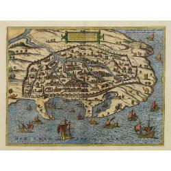
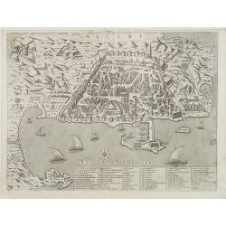
Alexandria vetustissimum AEgypti emporium
A superb image of Alexandria, the famous Egyptian center of learning. From Braun and Hogenberg's "Civitates Orbis Terrarum". An excellent example in fine period...
Date: Cologne, 1572
Selling price: ????
Please login to see price!
Sold in 2008
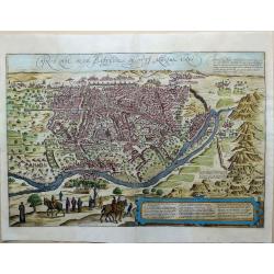
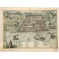
Cairus, quae olim Babylon; Aegypti Maxima Urbs.
A highly attractive map by Braun and Hogenberg of the city of Cairo oriented to the South. Running down the right-hand side we see a range of mountains on which the pyram...
Date: Köln, Bertram Buchholtz, 1572
Selling price: ????
Please login to see price!
Sold in 2022
(Cairo). Cairus Quae Olim Babilon Aegipti Maxima Urbs.
Descriptive Latin text to verso. The city of Cairo, made up of highly uniform cubic houses interspersed with minarets and gardens, is seen from the right bank of the Nile...
Date: Cologne, 1572
Selling price: ????
Please login to see price!
Sold in 2023
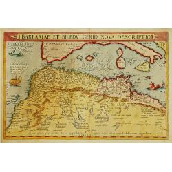
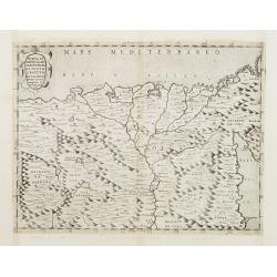
Barbariae et Biledulgerid, nova descriptio.
North-West Africa. Koeman speculated: ''In view of the important trading relationship between Antwerp and Africa, it is not impossible that the original was a manuscript ...
Date: Antwerp 1572
Selling price: ????
Please login to see price!
Sold
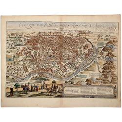
CAIRUS QUAE OLIM BABYLON AEGYPTI MAXIMA URBS.
A striking, old colored view of Cairo from a hillside opposite the Nile, from Braun & Hogenberg's groundbreaking Civitatus Orbis Terrarum, the most important town boo...
Date: Cologne, 1572
Selling price: ????
Please login to see price!
Sold in 2019
Tabula Aphricae I .
One of the earliest maps of Morocco and Tunisia, the northern coast of Africa, including Gibraltar and the Balearic islands. Early double page copperplate engraving from ...
Date: Venice, 1574
Selling price: ????
Please login to see price!
Sold in 2014
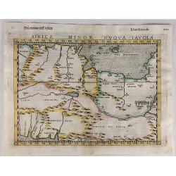
Africa Minor Nuova Tavola.
Striking impression of Ruscelli's map of the region of present day Algiers, Tunisia and Libya. Ruscelli sought the most up-to-date geographical information available, mak...
Date: Venice, 1574
Selling price: ????
Please login to see price!
Sold in 2020
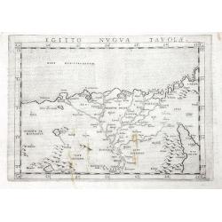
Egitto Nuova Tavola
One of the earliest obtainable maps of Egypt and the Nile delta.Extends to include Cairo, and a part of the Red Sea. Includes several pyramids. Italian text on verso.
Date: Venice, 1574
Selling price: ????
Please login to see price!
Sold in 2016
ALGERII Saracenorum Urbis Fortissimae in Numidea Africa Provincia. . .
A striking, old colored town plan of Algiers showing the formidably fortified town in a low bird's-eye view, with a figure bottom left dressed in a turban and kaftan, the...
Date: Cologne, 1575
Selling price: ????
Please login to see price!
Sold in 2020
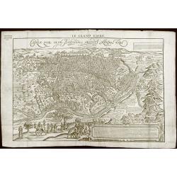
Le Grand Caire .
The first and only edition. Scarce map of Cairo by Francois De Belleforest, which appeared in the 1575 French edition of Munster's Cosmographia.Derived from the famous Br...
Date: Paris, 1575
Selling price: ????
Please login to see price!
Sold in 2013
![Tunes Oppidum Barbarie & Regina fedes 1535 ... [on sheet with] Africa olim Aphrodisum [and] Penon de Veles.](/uploads/cache/46226-250x250.jpg)
Tunes Oppidum Barbarie & Regina fedes 1535 ... [on sheet with] Africa olim Aphrodisum [and] Penon de Veles.
Three bird's-eye views of Tunis, Mahdia and Penon de Veles on one sheet. From the greatest publication in this genre!. The Civitates was compiled and written by George Br...
Date: Cologne, 1575
Selling price: ????
Please login to see price!
Sold in 2020
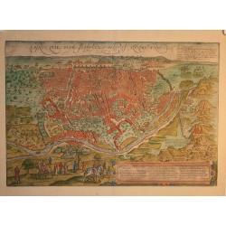
Cairus, quae olim Babylon, Aegypti Maxima urbs
This striking bird's-eye view of Cairo and the surrounding countryside includes depictions of the pyramids and the Sphinx. Several people are depicted in the foreground i...
Date: Cologne, ca 1575
Selling price: ????
Please login to see price!
Sold in 2010
LE GRANDE CAIRE, CAIRUS QUAE OLIM BABYLON AEGYPTI MAXIMA URBS.
A striking, old colored view of Cairo from a hillside opposite the Nile, the most important town book of the 16th Century. Elaborate detail, including fortified walls, bu...
Date: Paris, 1575
Selling price: ????
Please login to see price!
Sold in 2019
Tunes Urbs
Attractive city view of Tunis in Tunisia / Africa. Showing the Imperial attack on Tunis in 1573. Latin text on verso.
Date: 1575
Selling price: ????
Please login to see price!
Sold in 2009
![Tunes, Oppidum Barbarie &, Regia Sedes... [on sheet with] Africa, olim Aphrodisium [and] Penon de Veles.](/uploads/cache/46227-250x250.jpg)
Tunes, Oppidum Barbarie &, Regia Sedes... [on sheet with] Africa, olim Aphrodisium [and] Penon de Veles.
A bird's-eye panoramic view of Tunis in 1535 at top, Mahdia, south of Susa, in 1540 at lower left, and the island fortress of Penon de Veles in 1564 at lower right.From t...
Date: Cologne, 1575
Selling price: ????
Please login to see price!
Sold in 2020
![[Algiers].](/uploads/cache/14175-250x250.jpg)
[Algiers].
On recto an early representation of Algiers (142x185 mm). On verso a representation of a sword and a corona.From a French text edition of his Cosmographia , that great co...
Date: Basle, after 1575
Selling price: ????
Please login to see price!
Sold in 2012
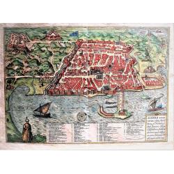
ALEXANDRIA Vetustissimum AEGYPTI emporium, Amplissima ciuitas ab Alexandro Magno sondia. . .
A striking, old colored town plan of Alexandria from Braun & Hogenberg's Civitas Orbis Terrarum, the most important town book of the 16th Century. Elaborate detail, i...
Date: Cologne, 1575
Selling price: ????
Please login to see price!
Sold in 2019
Cairus, quae olim Babylon , Aegypti Maxima Urbs.
Bird's-eye view of Cairo with key to locations.The Civitates was compiled and written by George Braun, Canon of Cologne Cathedral. Braun gathered together vast amounts of...
Date: Cologne, c.1575
Selling price: ????
Please login to see price!
Sold in 2013
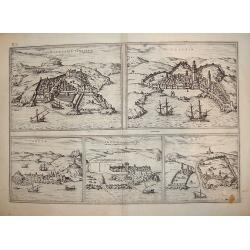
TUNES OPPIDUM Barbarie. . . - AFRICA APHRODISIUM - PENON DE VELES.
A striking sheet with three old colored, copper engraved views of Tunis, Mahdiya and Peñón de Vélez de la Gomera, from the second volume of Braun & Hogenberg's "...
Date: Cologne, 1575
Selling price: ????
Please login to see price!
Sold in 2019
![Tingis Lusitanis Tangiara [on sheet with] Tzaffin [and] Septa [and] Arzilla [and] Sala.](/uploads/cache/33684-250x250.jpg)
Tingis Lusitanis Tangiara [on sheet with] Tzaffin [and] Septa [and] Arzilla [and] Sala.
Five very desirable and early town-plans of Tangier, Safi, Ceuta, Asilah and Sala. "TANGIER (TANJA) : "The engraving shows a fortified town, whereby only half ...
Date: Cologne, (1572) 1577
Selling price: ????
Please login to see price!
Sold in 2020
Appendix III Tabulae Afr:
Ptolemaic map of Egypt bu Mercator.
Date: Cologne, 1578
Selling price: ????
Please login to see price!
Sold in 2010
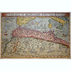
Barbariae et Biledulgerid, nova descriptio.
North-West Africa. Koeman speculated: In view of the important trading relationship between Antwerp and Africa, it is not impossible that the original was a manuscript ma...
Date: Antwerp, 1579
Selling price: ????
Please login to see price!
Sold in 2017
Affrica mit seinem befondern Landern Theiren und Wunderbarlichen Dingen.
Strong dark impression of Münster's small map of Africa, from a German edition of the "Cosmographia".One of the earliest obtainable maps of the African continen...
Date: Basle, 1579
Selling price: ????
Please login to see price!
Sold in 2010
Tab.II AFRICAE, Complectens AFRICAM Proprie dictam..
Ptolemeac map, shows the western part of the mediterranean with North-african coast, and parts of Sardinia and Sicily.The Island of Malta and Gozo right in the centre.
Date: Antwerp after 1580
Selling price: ????
Please login to see price!
Sold
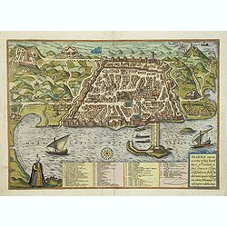
Algeri.
Rare view of the city of Algiers, with its fortifications, harbor and adjacent area by M.Florimi. With key a-Z, 1-48 of the principal buildings.Florimi\'s works are among...
Date: Siena, ca. 1580
Selling price: ????
Please login to see price!
Sold in 2008
ALGERII Sarace norum urbis fortissimae.
Attractive, old colored town-plan of the city of Alger, including a numbered key legend in the lower part. From the greatest publication in this genre!. The "Civitat...
Date: Cologne, 1580
Selling price: ????
Please login to see price!
Sold in 2019
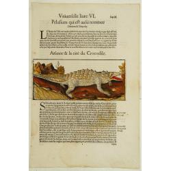
Crocodile and the town of Alexandrie.
A fine detailed woodcut depicting a crocodile on verso a view of Alexandria.
Date: Basle 1580
Selling price: ????
Please login to see price!
Sold
![[Lot with 12 maps of the Mediterraneans and Egypt.] Aegypti Recenttior Carthageni / General Karte des Roemischen Reichs](/uploads/cache/83963-250x250.jpg)
[Lot with 12 maps of the Mediterraneans and Egypt.] Aegypti Recenttior Carthageni / General Karte des Roemischen Reichs
A map of the Middle East and the Mediterranean. Taken from 'Algemeine Welthistorie (der Neuern Zeiten)', edited by S.J. Baumgarten, J.S.Semler a.o. Abraham Ortelius ...
Date: Antwerp, c. 1580
Selling price: ????
Please login to see price!
Sold in 2022
![[Egypt]](/uploads/cache/11856-250x250.jpg)
[Egypt]
On verso an early representation of Egypt (174x160mm).From a French text edition of his "Geographia", that great compendium of Renaissance knowledge.
Date: Basle 1550-1580
Selling price: ????
Please login to see price!
Sold
Cairus Quae Olim Babylon Aegypti Maxima Urbs.
Attractive bird-eye view of Cairo in Egypt with the Nile river, the Great Pyramids and Sphinx of Giza. Beautiful original color. German text on verso. From a German editi...
Date: Cologne, 1580
Selling price: ????
Please login to see price!
Sold in 2009
ALGERII Sarace norum urbis fortissimae.
An attractive town-plan of the Alger, including a numbered key legend in the lower part. From the greatest publication in this genre!. The "Civitates" was compi...
Date: Cologne, 1580
Selling price: ????
Please login to see price!
Sold in 2017
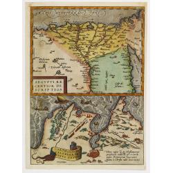
Aegypti recentior descriptio./ Carthaginis..
Two maps on one sheet. Upper part of the sheet (180x230mm) map of the northern part of Egypt with the Nile Delta. Lower part map of the north east corner of Africa with T...
Date: Antwerp, 1580
Selling price: ????
Please login to see price!
Sold in 2010
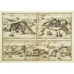
Tingis, Lusitanis, Tangiara. / Tzaffin. / Septa. / Arzilla.
Five views engraved on the same copper plate. Latin text.From the greatest publication in this genre!. The Civitates was compiled and written by George Braun, Canon of Co...
Date: Cologne, 1580
Selling price: ????
Please login to see price!
Sold
Tingis, Lusitanis, Tangiara. / Tzaffin. / Septa. / Arzilla.
Views of the five northern and western African coastal on one sheet: Latin text.From the greatest publication in this genre!. The Civitates was compiled and written by G...
Date: Cologne, 1580
Selling price: ????
Please login to see price!
Sold in 2011
![[Cultivation of grapes on Madeira].](/uploads/cache/14186-250x250.jpg)
[Cultivation of grapes on Madeira].
On recto an early representation of the cultivation of grapes (58x73 mm) on the island of Madeira. On verso a representation of a dog (42x75 mm) and of an exploding volca...
Date: Basle 1575-1580
Selling price: ????
Please login to see price!
Sold in 2015
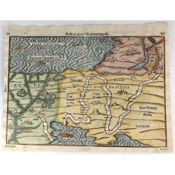
Reisen der Kinder von Israel aus Egypten.
This bold 434-year-old woodblock map illustrates the route taken by the Israelites in the Exodus from Egypt to the Promised Land. The map is very graphic with illustratio...
Date: Magdenburg, 1582
Selling price: ????
Please login to see price!
Sold in 2016
Aegypti recentior descriptio./ Carthaginis. . .
Two maps on one sheet. Upper part of the sheet (180 x 230 mm) is a map of the northern part of Egypt with the Nile Delta. Many small settlements are dotted along the leng...
Date: Antwerp, 1584
Selling price: ????
Please login to see price!
Sold in 2020
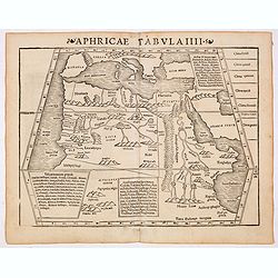
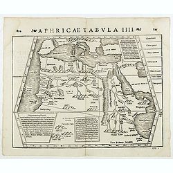
Africae Tabula Quarta. . .
The most general of the four Ptolemaic maps of Africa from Mercator’s definitive edition of Ptolemy’s geography. It extends far enough south to fully show Ptolemy’s endur...
Date: Cologne, ca 1584
Selling price: ????
Please login to see price!
Sold in 2019
Tingis, Lusitanis, Tangiara
A handsome five section map offering town-views of historically significant Portuguese empire North African coastal towns and entrepots, including Tangiers, Tzaffin, Ceut...
Date: Cologne, ca. 1585
Selling price: ????
Please login to see price!
Sold in 2011
