Popular Listings in America > North America

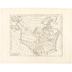
Région arctique.
1877 VIVIEN DE SAINT MARTIN, L. - Map of the North Pole, together with the often missing overlay with the Arctic expedition of Captain Nares.
Date: Paris, Hachette, 1877
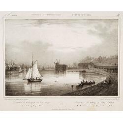
Pierpont's distillery on Long Island.
Milbert's topographical prints are an eyewitness record of life in America in the early 19th centuryDecorative print after Jacques Milbert, and lithographed by Sabatier a...
Date: Paris, 1829
![[United States map with Ottoman script.]](/uploads/cache/44314-250x250.jpg)
[United States map with Ottoman script.]
Postcard-size map in Ottoman script showing the United States, prepared by Mehmet EŞREF in a small atlas: عمومولاياةىشهانيىحاوىكوچكاطلاس [Umum-i vilayat-ı Şahaneyi havi...
Date: Istanbul, 1325 or 1909

A Hysterical Map Of Death Valley National Monument -- And It's Looking Mighty Low
First edition Humorous map of Death Valley. "Drawn In Broken English by Jolly Lindgren," this comic pictorial map is full of puns and comic vignettes related to...
Date: Spokane, Wash., Lindgren Brothers, 1948

Mappa Geographica provinciae Nova Ebboraci ab Anglis NEW-YORK dictae. . .
During the Revolution, this map afforded British commanders an excellent overview of areas that would be crucial in the early years of the war, particularly the Hudson Va...
Date: Nuremberg, 1778

Map of Pensylvania and New Jersey by H.S. Tanner.
First edition of this rare and important map of Pennsylvania and New Jersey by H.S. Tanner and published in his "New American Atlas" from 1823. Includes roads, ...
Date: Philadelphia, Henry Tanner, 1823
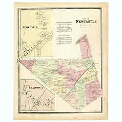
Town of New Castle. Westchester Co. NY.
Fine lithographed map of the town of New Castle. The map provides the names of specific homeowners, as well as information about the occupations and physical locations of...
Date: New York, 1867
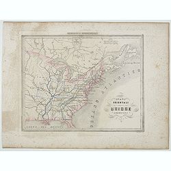
Stati Orientali della Unione Americana.
Uncommon map of Northeastern America prepared by Francesco Costantino Marmocchi. Above the map "Geografia Commerciale". From "Il Globo Atlante di carte Geo...
Date: Genova, Paolo Rivara fu Giacomo, 1858

Dutton Map of the Grand Canyon, Arizona (in 4 joined sheets)
An important 1882 map of the Grand Canyon, Arizona, published in "Atlas To Accompany The Monograph On The Tertiary History Of The Grand Canon District By Capt. Clare...
Date: Julius Bien and Co., 1882

The Greyhound Map of This Amazing America. . .
A large colored lithograph map of the USA, published by the Greyhound Corporation during the Second World War. The map demonstrates where all the Greyhound bus routes int...
Date: United States, 1941

Mappa geographica Provinciæ Nova Eboraci ab Anglis New-York . . .
Lower part of the two sheets map of Homann Heirs' edition of Sauthier's celebrated map of New York and New Jersey, made during the Revolutionary War. Appears in Homann's ...
Date: Nuremburg, 1778

Missions et Résidences dans la Partie Septentrionale de l'Amérique Contenant 50 Jésuites.
Very rare missionary map of North America from "Atlas Universel indiquant les établissemens des Jésuites: avec la manière dont ils divisent la terre, suivi desévénem...
Date: Paris, Ambroise Dupont , 1826
![Etats-Unis de L'Amerique Septentrionale. [Two sheets in manuscript ]](/uploads/cache/03972-250x250.jpg)
Etats-Unis de L'Amerique Septentrionale. [Two sheets in manuscript ]
Two sheets giving detailed information in French about the population in 1810, principal cities, products of industry and commerce, the financial situation for 1818, etc....
Date: France, ca. 1819
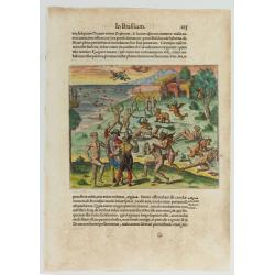
Cacodemon attacking the savages.
Cacodemon ("evil spirit") attacking the savages. Read more about "Les Grand Voyages" by Theodore De Bry [+]
Date: Frankfurt, 1594
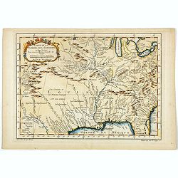
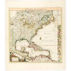
Carte de la Floride, de la Louisiane, et Pays Voisins. . .
Jacques Nicolaas Bellin (1703-1772) was one of the most important and proficient French cartographers of the mid-eighteenth century. He was appointed the first Ingenieur ...
Date: Paris, 1757

Nieuwe Kaart van de Grootbrittannische Volkplantingen in Noord America waar in Tevens de Fransche Bezittingen en de Landen tuschen die Beide Volken. . .
A map of the east-coast of America from New Foundland till Florida, divided in French and British properties. Reduced size Dutch edition of Mitchell's map of North Americ...
Date: Amsterdam, 1769
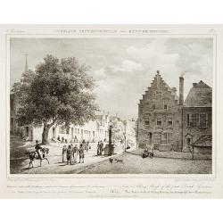
View in Albany-House of the first Dutch Governors.
Decorative print after Jacques Milbert, and lithographed by Tierpenne and the figures by Victor Adam.From Amérique Septentrionale. Printed by de Bove and Noöl ainé &C...
Date: Paris, 1829

Alabama. Official Highway map 1942.
Folding road map of Alabama. Published in Montgomery, Alabama by Paragon Press. Mileage chart and six city plans in margin; verso includes text and photos. Scale [ca. 1:8...
Date: Alabama, Paragon Press, 1942

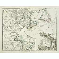
Nova tabula geographica complectens borealiorem..
A finely engraved pair of maps designed to be cut and joined together to provide a continuous coastline of North America from the Carolinas to Newfoundland and along the ...
Date: Amsterdam 1720

Carte du Golphe du Mexique et des Isles de l'Amerique.
Attractive map of the islands of the Caribbean that includes those parts of the United States & Mexico that border the Gulf of Mexico, Central America, and the northe...
Date: Paris, 1754

Tartariae sive Magni Chami Imperium.
This is a very early depiction of the northern Pacific, with the first mapping of Northwest Coast of America and probably the first map to name California 'C. Califormio...
Date: Antwerp, c. 1608-1612
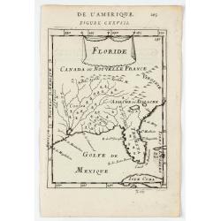
Floride.
A charming map of Florida, also showing Cuba, Golf of Mexico & St Augustine.Title in curtain draped at top. French text on verso.From the original 1683 text edition o...
Date: Paris, 1683

Upper Canada &c.
A beautiful, large scale map of Upper Canada, and portions of the American states of New York, Ohio, and Pennsylvania. The province of 'Upper' Canada was created by the B...
Date: London, 1839
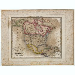
Nuovo Mondo parte Settentrionale.
Uncommon map of North America prepared by Francesco Costantino Marmocchi. Above the map "Geografia Commerciale". From "Il Globo Atlante di carte Geografich...
Date: Genova, Paolo Rivara fu Giacomo, 1858
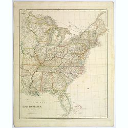
United States.
A lovely large map of the Untied States, as it was at the time of publication. Each state shown in a different outline color. Nothing is shown west of Louisiana, Arkansas...
Date: London, 1839

Amerique septentrionale divisee en ses principales parties, ou sont distingues les vns des autres les estats suivant qu'ils appartiennent presentemet aux Francois, Castillans, Anglois, Suedois, Danois, Hollandois...
This handsome map shows California as an island, open-ended Great Lakes, and other details based mainly on Sanson. A large decorative cartouche occupies the area of the n...
Date: Paris, after 1694

Carte nouvelle de l'Amérique angloise contenant tout ce que les Anglois possèdent. . . avec la Floride / gravée. . . par Maththias Albert Lotter. . .
As mentioned in the title piece, the map includes the area at that time in the possession of the English, i.e. Canada, New Large, beautiful and detailed map of the Easter...
Date: Augsburg, 1777
Carte de la Nouvelle Angleterre, Nouvelle York et Pensilvanie / Pour servir à l'Histoire Générale des Voyages.
Uncommon edition of this accurate map the east coast from Delaware River till Main.Left hand corner Lake Ontario. In lower right engraved "38."From Atlas Portat...
Date: Amsterdam, 1773

Carte de la partie septentrionale des Etats Unis..
An attractive 1801 map of North America's east coast north of Long Island. Including St.Laurence River as far south as Lake Ontario. Engraved by André and P.F.Tardieu. A ...
Date: Paris, 1801

La parte orientale dell' antico.. messico con la Florida..
A splendid two-sheet map of Mexico, including California, Arizona, New Mexico, part of Texas, Baja California and Mexico (west part) and of the Southeast Part of the US, ...
Date: Rome, Calcography, 1797-before 1839
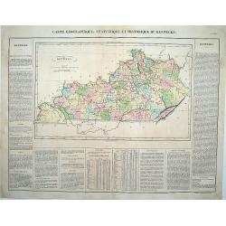
Carte Géographique .. Kentucky.
Detailed map of Kentucky. From J.A. Buchon, "Atlas Gégraphique Statistique, historique et chronologique des deux Ameriques et des isles adjacentes; traduit de l'atla...
Date: Paris, 1825
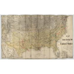
Map showing the cotton growing belt in the United States Prepared for and copyrighted by Geo. H.Mc.Fadden & Bro., cotton merchands based in Phiiladelphia, USA 1892.
The cotton-growing Belts in the Southern States for 1892 A rare map showing the cotton-growing Belts in the Southern States for 1892. Prepared for and copyrighted by G...
Date: Philadelphia, 1892
Carte des parties nord et ouest de L' Amerique. . .
An interesting map of North America, based upon an earlier map by Thomas Engel. His map of North America was issued in his 'Memoires Observations Geographique' in 1765, a...
Date: Paris, 1772
Amerique Septentrionale suivant la carte de Pople faite à Londres en 20 feuilles.
The key sheet to Henry Le Rouge/Popple wall map of the British Colonies in North America. Appears in the author's Atlas Général [1741-62].Key map of the French edition ...
Date: Paris, Le Rouge, 1742
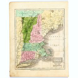
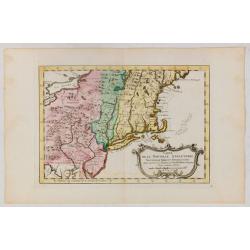
Eastern States.
A map of the eastern US seaboard from Long Island north to Lower Canada, comprising the states of Connecticut, Rhode Island, Massachusetts, New Hampshire, Maine, Vermont ...
Date: Connecticut, 1839
![[Lower half] Amerique Septentrionale avec les Routes, Distances en miles, Limites et Etablissements François et Anglois Par le Docteur Mitchel Traduit de 'Anglois..](/uploads/cache/49378-250x250.jpg)
[Lower half] Amerique Septentrionale avec les Routes, Distances en miles, Limites et Etablissements François et Anglois Par le Docteur Mitchel Traduit de 'Anglois..
This is the important 1777 French edition by Georges Le Rouge of the seminal John Mitchell map of eastern North America. The Mitchell map is considered the single most im...
Date: Paris, 1777
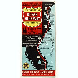
New York - Miami Ocean Highway. Pines to Palms. - Ocean Highway Official Highway Route Approved and Sponsored by the Ocean Highway Association.
Vintage road map showing "The Route of the Experience Motorist" features mileage information in the right margin. Verso features information on cities along the...
Date: Washington, ca. 1947
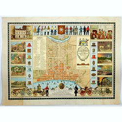
A Map of the City of Philadelphia, showing the Location of the Volunteer Fire Companies. . .
A fine, large pictorial plan of the City of Philadelphia, based on the drawing by Jacob Riegel in 1937, which itself was based on an earlier work dating back to 1794. The...
Date: Philadelphia, 1938
Partie de l'Amerique septent? Qui comprend la nouvelle France. . .
A fine copy of this map of New Foundland, Nova Scotia and the course of the St.Lawrence to Lake Ontario in a forth state.An inset shows Bellini's famous and important map...
Date: Paris, 1755-1778
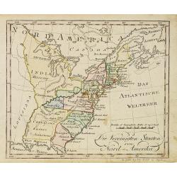
Die Vereinigten Staaten von Nord-Amerika.
Nice little German map of the early United States. The only state shown west of the Appalachian Mountains is Kentucky. Above which is a strangely shaped unnamed region (O...
Date: Augsburg, 1812
