Browse Listings
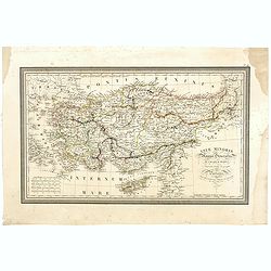
Asiae Minoris Stappa generalis ad Caesarum tempus.
A lovely steel engraved map of Turkey, Cyprus and Minor Asia. From Louis de Saint-Martin Vivien's Atlas Universel. Engraved by Giraldon-Bovinet.
Date: Paris, 1826
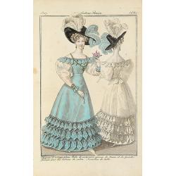
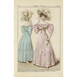
Chapeau de velours plain.. (2561)
From Costume Parisien (1797-1839).Paris was the capital for fashion innovation and design. After the final defeat of Napoleon, English and French fashions merged to close...
Date: Paris, 1827
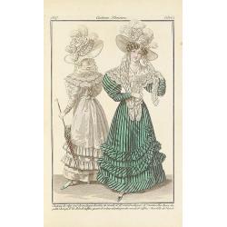
Chapeau de crépe orné de rouleaux.. (2502)
From Costume Parisien (1797-1839).Paris was the capital for fashion innovation and design. After the final defeat of Napoleon, English and French fashions merged to close...
Date: Paris, 1827
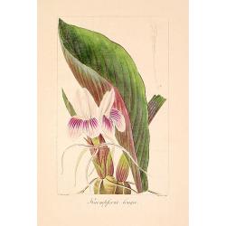
Kaempferia longa.
"Copperplate finished by hand, from ""Herbier général de l'amateur, contenant la description, l'histoire, les propriétés et la culture des végétaux u...
Date: Paris, 1814-1827
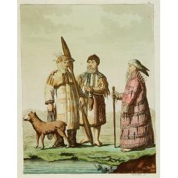
Habillement des Groënlandais.
Natives of Greenland. This aquatint engraved plate was color printed on fine wove paper of a soft aged white color, bearing the embossed seal of authenticity impressed at...
- $75 / ≈ €65
Date: Milan, 1827
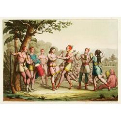
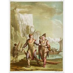
Danse d'indiens.
From Giulio Ferrario's work Le Costume ancien et moderne ou histoire du gouvernement, de la milice, de la religion, des arts, etc. published in Milan by the author betwee...
- $50 / ≈ €43
Date: Milan, 1827
Les Aleuts.
From Giulio Ferrario's work Le Costume ancien et moderne ou histoire du gouvernement, de la milice, de la religion, des arts, etc. published in Milan by the author betwee...
- $50 / ≈ €43
Date: Milan, 1827
Chapeau de paille d'Italie.. (2546)
From Costume Parisien (1797-1839).Paris was the capital for fashion innovation and design. After the final defeat of Napoleon, English and French fashions merged to close...
Date: Paris, 1827
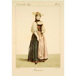
Bernoise.
A decorative costume print from "Costume de div. Pays", No.17. Engraved by Getine after Lanté.
- $80 / ≈ €69
Date: Paris, c. 1827
![[Family from Kyrgyz Republic - Costumes des Kirguises]](/uploads/cache/24477-250x250.jpg)
[Family from Kyrgyz Republic - Costumes des Kirguises]
Aquatint engraved by D.K. Bonatti, after drawings by C. Bottigella. Showing a family in typical dress from the Kyrgyz Republic. Man is holding a bird.In the late nineteen...
- $70 / ≈ €61
Date: Milan, 1827
![[Taoism religion of the Callmoucks].](/uploads/cache/25834-250x250.jpg)
[Taoism religion of the Callmoucks].
Aquatint depicting six Taoist deities engraved by D.K. Bonatti, after drawings by C. Bottigella. Plate N° 43. The Tatars people which live almost all in the north of Asi...
- $45 / ≈ €39
Date: Milan, 1827
![[ Tartars ].](/uploads/cache/25836-250x250.jpg)
[ Tartars ].
Aquatint depicts a group of Taguri Tartars of the Crimea in traditional attire, engraved by D.K. Bonatti, after drawings by G.Gattina. Plate N° 45 From Giulio Ferrari...
- $45 / ≈ €39
Date: Milan, 1827
![[Sumatra plants ].](/uploads/cache/25837-250x250.jpg)
[Sumatra plants ].
Aquatint depicting coffee, pepper et other plants in Sumatra. Plate N° 46.From Giulio Ferrario's work Le Costume Ancien et Moderne ou Histoire du gouvernement, de la mil...
- $50 / ≈ €43
Date: Milan, 1827
![[No title]. [Two locals of the island of Ubi ].](/uploads/cache/25845-250x250.jpg)
[No title]. [Two locals of the island of Ubi ].
Aquatint depicting two locals, one rowing to shore, the other searching for sea shells on the Island of Ubi in the Moluccas. Engraved by Carlo Bottigella. From Giulio Fer...
- $40 / ≈ €35
Date: Milan, 1827
![[ Island of Bouro with a view of Cayeli ].](/uploads/cache/25846-250x250.jpg)
[ Island of Bouro with a view of Cayeli ].
Aquatint depicts a view of Cayeli on the island of Bouro. Engraved by G.Castellini. Plate N° 55.From Giulio Ferrario's work Le Costume Ancien et Moderne ou Histoire du g...
- $50 / ≈ €43
Date: Milan, 1827
![[ A man and woman from Timor ].](/uploads/cache/25847-250x250.jpg)
[ A man and woman from Timor ].
Aquatint depicting a man and woman from Timor, engraved by A.Biasioli. Plate N° 56. The weaving of traditional scarves or tais is widespread in East Timor. From Giulio...
- $50 / ≈ €43
Date: Milan, 1827
![[ Ippah village New Zealand ].](/uploads/cache/25857-250x250.jpg)
[ Ippah village New Zealand ].
Aquatint depicting a view of Ippah, a village built on a rock. Engraved by G.Castellini. Plate N° 66. From Giulio Ferrario's work Le Costume Ancien et Moderne ou Histoir...
- $100 / ≈ €87
Date: Milan, 1827
![[Mongolian pipe smoking ].](/uploads/cache/26258-250x250.jpg)
[Mongolian pipe smoking ].
Aquatint depicting a group of Mongolians in traditional attire during a pipe smoking ceremony. Chinese and Mongolian tradition had tobacco smoking from pipes with small m...
- $80 / ≈ €69
Date: Milan, 1827
![[Fauna and flora - Siberia].](/uploads/cache/25815-250x250.jpg)
[Fauna and flora - Siberia].
Aquatint depicting a donkey, a weasel and a squirrel, and three botanical plants in Siberia engraved by C.A.Raineri, after drawings by C. Bottigella. Plate N° 22.From Gi...
- $50 / ≈ €43
Date: Milan, 1827
![[Tartares Katschins ].](/uploads/cache/25818-250x250.jpg)
[Tartares Katschins ].
Aquatint depicting people from Tartary engraved by Cantelli, after drawings by C. Bottigella. Plate N° 26.From Giulio Ferrario's work Le Costume Ancien et Moderne ou His...
- $50 / ≈ €43
Date: Milan, 1827
![[Ostiaks ].](/uploads/cache/25822-250x250.jpg)
[Ostiaks ].
Aquatint depicting a Ostiaks people engraved by D.K. Bonatti, after drawings by C. Bottigella.The Ostiak people are a tribe who inhabit the basin of the Ob in western Sib...
- $50 / ≈ €43
Date: Milan, 1827
![[Samoyedes ].](/uploads/cache/25823-250x250.jpg)
[Samoyedes ].
Aquatint depicting Samoyedes warming up around a camp fire engraved by D.K. Bonatti, after drawings by C. Bottigella. The Samoyedes is a tribe of the Ural-Altaic group, s...
- $50 / ≈ €43
Date: Milan, 1827
![[Yakuts ].](/uploads/cache/25825-250x250.jpg)
[Yakuts ].
Aquatint depicting Yakuts in traditional dress engraved by D.K. Bonatti, after drawings by C. Bottigella.The Yakuts live in the Republic of Sakha (YakutiaYakutia), Khabar...
- $75 / ≈ €65
Date: Milan, 1827
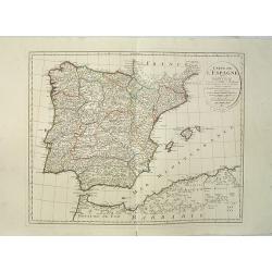
Carte de l'Espagne Dressée par Guillaume Delisle sur la description de Rodrigo Mendez Sylva . . .. Le tout augmenté et vérifié en 1789. Par Phil. Buache, de l'Académie des Sciences.
Map of Spain and Portugal, including the North African coast and good detail for Majorca, Minorca and Ibiza. Published by Dezauche at his address Rue de Sorbonne, n°9, a...
Date: Paris, 1827
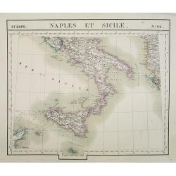
Europe. Naples et Sicile. N.26.
Detailed map including lower half of Italy with the island of Sicily.From his famous Atlas Universel . This atlas was one of the most remarkable world atlases ever produc...
Date: Brussels, 1825-1827
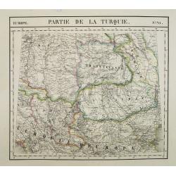
Europe. Partie de la Turquie. N°21.
Detailed map including Hungary and Romania.From his famous Atlas Universel . This atlas was one of the most remarkable world atlases ever produced, anticipating the Inter...
Date: Brussels, 1825-1827
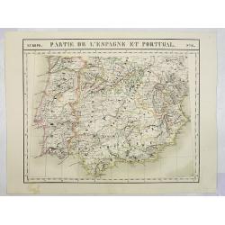
Europe. Partie de l'Espagne et Portugal. N°24.
Detailed map including Southern part of Spain and Portugal.From his famous Atlas Universel . This atlas was one of the most remarkable world atlases ever produced, antici...
Date: Brussels, 1825-1827
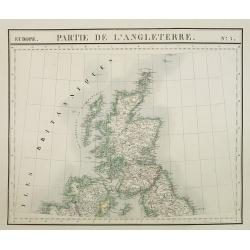
Europe. Partie de l'Angleterre. N°7.
Detailed map including Northern part of England.From his famous Atlas Universel . This atlas was one of the most remarkable world atlases ever produced, anticipating the ...
- $100 / ≈ €87
Date: Brussels, 1825-1827
![[The Callo Palace ].](/uploads/cache/27288-250x250.jpg)
[The Callo Palace ].
Aquatint depicting Peruvian Inca Palace called Callo.Engraved by Fumagalli.From Giulio Ferrario's work Le Costume Ancien et Moderne ou Histoire du gouvernement, de la mil...
- $80 / ≈ €69
Date: Milan, 1827
![[The Callo Palace.]](/uploads/cache/27289-250x250.jpg)
[The Callo Palace.]
Aquatint depicting upper portion of print an Inca Palace near Cannar in the province of Quito in Peru. Bottom portion a plan of the palace (70 x 160).Engraved by Fumagall...
- $80 / ≈ €69
Date: Milan, 1827
![[Spanish Sheppard's in Paraguay ].](/uploads/cache/27290-250x250.jpg)
[Spanish Sheppard's in Paraguay ].
Aquatint depicting Spanish Sheppard's in Paraguay.Engraved by Gallina.From Giulio Ferrario's work Le Costume Ancien et Moderne ou Histoire du gouvernement, de la milice, ...
- $50 / ≈ €43
Date: Milan, 1827
![[ The circular fortress of Cannar, Peru. ]](/uploads/cache/27292-250x250.jpg)
[ The circular fortress of Cannar, Peru. ]
Aquatint depicting the circular fortress of Cannar, Peru.Engraved by Fumagalli.From Giulio Ferrario's work Le Costume Ancien et Moderne ou Histoire du gouvernement, de la...
- $80 / ≈ €69
Date: Milan, 1827
![[ Fortresss of Cannar in Quito Peru ].](/uploads/cache/27293-250x250.jpg)
[ Fortresss of Cannar in Quito Peru ].
Aquatint depicting the fortress of Cannar in Quito Peru inspired by a print from atlas by Alexander Von Humboldt.Engraved by E. F.From Giulio Ferrario's work Le Costume A...
- $80 / ≈ €69
Date: Milan, 1827
![[ Santiago inhabitants in their local dress. ]](/uploads/cache/27294-250x250.jpg)
[ Santiago inhabitants in their local dress. ]
Aquatint depicting inhabitants of Santiago in local dress.Engraved by Gallina.From Giulio Ferrario's work Le Costume Ancien et Moderne ou Histoire du gouvernement, de la ...
- $50 / ≈ €43
Date: Milan, 1827
![[ Guayanas inhabitants Paraguay ].](/uploads/cache/27295-250x250.jpg)
[ Guayanas inhabitants Paraguay ].
Aquatint depicting some relexing Guayanas Indians of Paraguay, who occupy the rivers flowing to the right bank of the Parana.The Charruas Indians were the first inhabitan...
- $50 / ≈ €43
Date: Milan, 1827
![[ Charruas Indians from Paraguay ].](/uploads/cache/27296-250x250.jpg)
[ Charruas Indians from Paraguay ].
Aquatint depicting the Charruas Indians cooking. The charruas Indians were the first inhabitants who hunted and fished in the area now known as Uruguay. They have probabl...
- $60 / ≈ €52
Date: Milan, 1827
![[ Indians playing Queciu (top) and Porotos (bottom) ].](/uploads/cache/27298-250x250.jpg)
[ Indians playing Queciu (top) and Porotos (bottom) ].
Aquatint depicting Indians playing Queciu (top) and Porotos (bottom).Engraved by Fumagalli.From Giulio Ferrario's work Le Costume Ancien et Moderne ou Histoire du gouvern...
- $50 / ≈ €43
Date: Milan, 1827
![[ Chilean indians playing ciueca ].](/uploads/cache/27299-250x250.jpg)
[ Chilean indians playing ciueca ].
Aquatint depicting Chilean indians playing "ciueca", a native hockey-like game.Engraved by Fumagalli.From Giulio Ferrario's work Le Costume Ancien et Moderne ou...
- $75 / ≈ €65
Date: Milan, 1827
![[Jesuitical Indians at work at their 'Reducciones' ]](/uploads/cache/27300-250x250.jpg)
[Jesuitical Indians at work at their 'Reducciones' ]
Aquatint depicting Jesuitical Indians in Paraguay. The Jesuit Missions or "Reducciones" functioned like small independent "republics" and lived in com...
- $80 / ≈ €69
Date: Milan, 1827
![[Araucani chief and his entourage from Chile ].](/uploads/cache/27302-250x250.jpg)
[Araucani chief and his entourage from Chile ].
Aquatint depicting an Araucani chief and his entourage. They were known as the toughest indigenous people of South America. The Araucans are Amerindian tribes habiting th...
- $85 / ≈ €74
Date: Milan, 1827
![[Indians of Patagonia, Chile, greeting a European traveller, probably Louis Antoine de Bougainville. ]](/uploads/cache/27303-250x250.jpg)
[Indians of Patagonia, Chile, greeting a European traveller, probably Louis Antoine de Bougainville. ]
Aquatint depicting Indians of Patagonia, Chile, greeting a European traveller, probably Louis Antoine de Bougainville. Comte de Bougainville was a French admiral and expl...
- $75 / ≈ €65
Date: Milan, 1827
![[Yacanacus inhabitants of Tierra del Fuego ].](/uploads/cache/27304-250x250.jpg)
[Yacanacus inhabitants of Tierra del Fuego ].
Aquatint depicting Yacanacus natives of Tierra del Fuego.Engraved by Gallina.From Giulio Ferrario's work Le Costume Ancien et Moderne ou Histoire du gouvernement, de la m...
- $100 / ≈ €87
Date: Milan, 1827
![[Birds from Brazil ].](/uploads/cache/27307-250x250.jpg)
[Birds from Brazil ].
Aquatint depicting 6 different species of birds from Brazil. Engraved by Raineri.From Giulio Ferrario's work Le Costume Ancien et Moderne ou Histoire du gouvernement, de ...
- $75 / ≈ €65
Date: Milan, 1827
![[Coroados artifacts from Brazil ].](/uploads/cache/27309-250x250.jpg)
[Coroados artifacts from Brazil ].
Aquatint depicting artifacts used by the Coroados tribe of Brazil.Engraved by Fumagalli.From Giulio Ferrario's work Le Costume Ancien et Moderne ou Histoire du gouverneme...
- $80 / ≈ €69
Date: Milan, 1827
![[Camacan indians in Brazil ].](/uploads/cache/27312-250x250.jpg)
[Camacan indians in Brazil ].
Aquatint depicting the Camacan indians in the Amazonian forest.Engraved by Fumagalli.From Giulio Ferrario's work Le Costume Ancien et Moderne ou Histoire du gouvernement,...
- $70 / ≈ €61
Date: Milan, 1827
![[Camacani Indian artifacts ].](/uploads/cache/27316-250x250.jpg)
[Camacani Indian artifacts ].
Aquatint depicting Camacani Indian artifacts.Engraved by Gallina.From Giulio Ferrario's work Le Costume Ancien et Moderne ou Histoire du gouvernement, de la milice, de la...
- $75 / ≈ €65
Date: Milan, 1827
![[Patacho Tribesmen of the Rio do Prado. ]](/uploads/cache/27317-250x250.jpg)
[Patacho Tribesmen of the Rio do Prado. ]
A native Patacho Tribesman is about to cut open a piece of fruit (melon?) with a hatchet while another holds a bow and arrows or spears while looking on. Behind them are ...
- $60 / ≈ €52
Date: Milan, 1827
![[Botocudos tribe artifacts ].](/uploads/cache/27318-250x250.jpg)
[Botocudos tribe artifacts ].
Aquatint depicting artifacts from the Botocudos tribel.Engraved by Gallina.From Giulio Ferrario's work Le Costume Ancien et Moderne ou Histoire du gouvernement, de la mil...
- $60 / ≈ €52
Date: Milan, 1827
![[Botocudos tribe of the Rio Grande, Paraguay ].](/uploads/cache/27320-250x250.jpg)
[Botocudos tribe of the Rio Grande, Paraguay ].
Aquatint depicting Botocudos tribe of the Rio Grande in Paraguay.Botocudo (from Portuguese for botoque, a plug, in allusion, to the wooden disks or plugs worn in their li...
- $120 / ≈ €104
Date: Milan, 1827
![[ Pampas Indians near Buenos Aires in Argentina ].](/uploads/cache/27322-250x250.jpg)
[ Pampas Indians near Buenos Aires in Argentina ].
Aquatint depicting the Pampas Indians in front of a local shop near Buenos Aires.Engraved by Bonatti.From Giulio Ferrario's work Le Costume Ancien et Moderne ou Histoire ...
- $100 / ≈ €87
Date: Milan, 1827
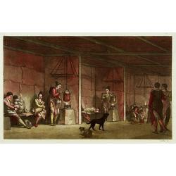
![[Gauchos near Buenos Aires in Argentina ].](/uploads/cache/27323-250x250.jpg)
[Gauchos near Buenos Aires in Argentina ].
Aquatint depicting some Gauchos cooking and relaxing near Buenos Aires. Engraved by Bonatti.From Giulio Ferrario's work Le Costume Ancien et Moderne ou Histoire du gouv...
- $75 / ≈ €65
Date: Milan, 1827
![[ Soldiers near the river banks of the River Plate ].](/uploads/cache/27324-250x250.jpg)
[ Soldiers near the river banks of the River Plate ].
Aquatint depicting soldiers living near the river banks of the River Plate, an estuary formed by a combination of Uruguay rivers and the Parana River. It is located at th...
- $75 / ≈ €65
Date: Milan, 1827
![[ A square at Buenos Aires. ]](/uploads/cache/27329-250x250.jpg)
[ A square at Buenos Aires. ]
Aquatint depicting a suare at Buenos Aires.Engraved by Fumigalli.From Giulio Ferrario's work Le Costume Ancien et Moderne ou Histoire du gouvernement, de la milice, de la...
- $75 / ≈ €65
Date: Milan, 1827
![[ Market Place at Buenos Aires. ]](/uploads/cache/27330-250x250.jpg)
[ Market Place at Buenos Aires. ]
Aquatint depicting a lifely scene of the Market Place Buenos Aires with its merchants.Engraved by Fumigalli.From Giulio Ferrario's work Le Costume Ancien et Moderne ou Hi...
- $75 / ≈ €65
Date: Milan, 1827
![[ A Teocalli in Mexico - Aztec Temple ].](/uploads/cache/27580-250x250.jpg)
[ A Teocalli in Mexico - Aztec Temple ].
Aquatint depicting a Aztec Temple engraved by Fumagalli. From Giulio Ferrario's work Le Costume Ancien et Moderne ou Histoire du gouvernement, de la milice, de la religio...
- $150 / ≈ €130
Date: Milan, 1827
![[Tibetan Gilong monk].](/uploads/cache/25835-250x250.jpg)
[Tibetan Gilong monk].
Aquatint depicting a Tibetan Gilong monk with persons from the City of Karakoran engraved by D.K. Bonatti, after drawings by C. Bottigella of a family of Turkestan. Plate...
- $100 / ≈ €87
Date: Milan, 1827
![[ A view of a Caribbean sugar plantation ].](/uploads/cache/27335-250x250.jpg)
[ A view of a Caribbean sugar plantation ].
Aquatint depicts a Caribbean (probably sugar) plantation. Engraved by Fumagalli.From Giulio Ferrario's work Le Costume Ancien et Moderne ou Histoire du gouvernement, de ...
Date: Milan, 1827
![[Costume plate of locals of Dourans tribe in Afganistan]](/uploads/cache/62330-250x250.jpg)
[Costume plate of locals of Dourans tribe in Afganistan]
Aquatint showing locals of Dourans tribe in Afghanistan in their typical dress. Plate N° 1. Engraved by C. Bottigella.From Giulio Ferrario's work Le Costume ancien et mo...
- $50 / ≈ €43
Date: Milan, 1827
![[Costume plate of locals of Afganistan]](/uploads/cache/62331-250x250.jpg)
[Costume plate of locals of Afganistan]
Aquatint showing locals of Afghanistan in their typical dress. Plate N° 2. Engraved by D.K.Bonatti.From Giulio Ferrario's work Le Costume ancien et moderne ou histoire d...
- $60 / ≈ €52
Date: Milan, 1827
![[Afganistans in their typical dress]](/uploads/cache/62332-250x250.jpg)
[Afganistans in their typical dress]
Aquatint showing local of Afghanistan in their typical dress. Plate N° 3.From Giulio Ferrario's work Le Costume ancien et moderne ou histoire du gouvernement, de la mili...
- $50 / ≈ €43
Date: Milan, 1827
![[Tassisoudon Palace - Palace Lama Chassatou]](/uploads/cache/62335-250x250.jpg)
[Tassisoudon Palace - Palace Lama Chassatou]
Two aquatint prints on one sheet show the Tassisoudon Palace and the Palace of Lama Chassatou in Tibet. Plate N° 6. From Giulio Ferrario's work Le Costume ancien et mode...
- $150 / ≈ €130
Date: Milan, 1827
![[View of Castle and Bridge Vandipore - Bhutan - Tibet ]](/uploads/cache/62336-250x250.jpg)
[View of Castle and Bridge Vandipore - Bhutan - Tibet ]
Aquatint print with a view of Castle and Bridge, Vandipore - Bhutan - Tibet. Plate N° 7. From Giulio Ferrario's work Le Costume ancien et moderne ou histoire du gouverne...
- $100 / ≈ €87
Date: Milan, 1827
[Gyap, father of the young Teschou Lama
Aquatint print with Gyap, father of the young Teschou Lama and his wife and the portrait of the Grand Lama. - Tibet. Plate N° 8. This is from Giulio Ferrario's work Le ...
- $80 / ≈ €69
Date: Milan, 1827
![[Costume plate of Grebenski Cossacks in the Caucasus]](/uploads/cache/62339-250x250.jpg)
[Costume plate of Grebenski Cossacks in the Caucasus]
Aquatint costume plate of Grebenski Cossacks in the Caucasus. Plate N° 10. From Giulio Ferrario's work Le Costume ancien et moderne ou histoire du gouvernement, de la mi...
Date: Milan, 1827
![[Costumes des Karabulaks - Caucase]](/uploads/cache/62344-250x250.jpg)
[Costumes des Karabulaks - Caucase]
Four men from the Caucasus in typical dress from the Karabulaks tribe. Plate N° 15. from Giulio Ferrario's work "Le Costume Ancien et Moderne ou Histoire du gouvern...
Date: Milan, 1827
![[The procession of the regent of Tibet going to Teschou-Lumbou.]](/uploads/cache/62333-250x250.jpg)
[The procession of the regent of Tibet going to Teschou-Lumbou.]
Aquatint showing the procession of the regent of Tibet going to Teschou-Lumbou.. Plate N° 4.From Giulio Ferrario's work Le Costume ancien et moderne ou histoire du gouve...
- $100 / ≈ €87
Date: Milan, 1827
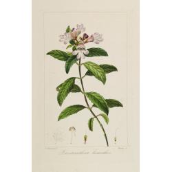
Prostranthera lasianthos.
Copperplate finished by hand, from "Herbier général de l'amateur, contenant la description, l'histoire, les propriétés et la culture des végétaux utiles et agr...
- $75 / ≈ €65
Date: Paris, 1814-1827
Intérieur d'une maison groënlandaise.
This aquatint engraved plate was color printed on fine move paper of a soft aged white color, bearing the embossed seal of authenticity impressed at the time of publicati...
- $75 / ≈ €65
Date: Milan 1827
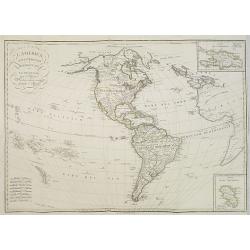
L'America Settentrionale e Meridionale . . .
Map depicting the Americas with two inset maps of the Dominican Republic and Martinique.From Giulio Ferrario's work Le Costume Ancien et Moderne ou Histoire du gouverneme...
Date: Milan, 1827
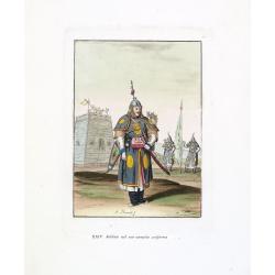
Soldato nel suo compito uniforme (Chinese soldier in full battle dress)
Aquatint with original coloring by Antonio Rancati, taken from Giulio Ferrario's work Le Costume ancien et moderne ou histoire du gouvernement, de la milice, de la religi...
- $80 / ≈ €69
Date: Milan, 1827
Tende, Stendardi (Chinese Military Equipment)
Aquatint with original coloring by Antonio Rancati, taken from Giulio Ferrario's work Le Costume ancien et moderne ou histoire du gouvernement, de la milice, de la religi...
- $80 / ≈ €69
Date: Milan, 1827
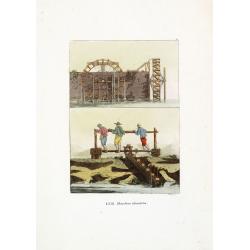
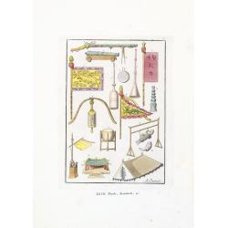
Macchine idrauliche. (Chinese hydraulic machines)
Aquatint with original coloring by G. Rossi, taken from Giulio Ferrario's work Le Costume ancien et moderne ou histoire du gouvernement, de la milice, de la religion, des...
- $50 / ≈ €43
Date: Milan, 1827
![[ The ruins of Mitla ].](/uploads/cache/27584-250x250.jpg)
[ The ruins of Mitla ].
Aquatint depicting the ruins of Mitla engraved by Fumagalli. Plate N°74.A pre-Columbian Mesoamerican building.From Giulio Ferrario's work Le Costume Ancien et Moderne ou...
- $45 / ≈ €39
Date: Milan, 1827
![[The ruins of Mitla ].](/uploads/cache/27585-250x250.jpg)
[The ruins of Mitla ].
Aquatint depicting the ruins of Mitla engraved by Fumagalli. Plate N°75.A pre-Columbian Mesoamerican building.From Giulio Ferrario's work Le Costume Ancien et Moderne ou...
- $60 / ≈ €52
Date: Milan, 1827
![[ Local musical instruments ].](/uploads/cache/27586-250x250.jpg)
[ Local musical instruments ].
Aquatint depicting local musical instruments being played engraved by Bonatti Plate N°76.From Giulio Ferrario's work Le Costume Ancien et Moderne ou Histoire du gouverne...
- $50 / ≈ €43
Date: Milan, 1827
![[ Emblematic figures and numeric characters ].](/uploads/cache/27588-250x250.jpg)
[ Emblematic figures and numeric characters ].
Aquatint depicting emblematic figures and numeric characters engraved by Gallina. Plate N°79.From Giulio Ferrario's work Le Costume Ancien et Moderne ou Histoire du gouv...
- $75 / ≈ €65
Date: Milan, 1827
![[ Mexican Temazcalli or vapor baths ].](/uploads/cache/27738-250x250.jpg)
[ Mexican Temazcalli or vapor baths ].
Aquatint depicting a Mexican Temazcalli by Fumagalli. . As a great preventive against disease the Mexicans used the bath frequently—especially the Temazcalli, or vapor-...
- $100 / ≈ €87
Date: Milan, 1827
![[ LXXII. Divertimenti de' serpenti ].](/uploads/cache/34981-250x250.jpg)
[ LXXII. Divertimenti de' serpenti ].
Aquatint depicting snake charmers engraved by D.Klemi-Bonatti, Plate N°60.From Giulio Ferrario's work Le Costume Ancien et Moderne ou Histoire du gouvernement, de la mil...
- $50 / ≈ €43
Date: Milan, 1827
![[XXIII Infanteria ].](/uploads/cache/34982-250x250.jpg)
[XXIII Infanteria ].
Aquatint depicting Chinese infantry engraved by G Bigatti, Plate N°23.From Giulio Ferrario's work Le Costume Ancien et Moderne ou Histoire du gouvernement, de la milice,...
- $50 / ≈ €43
Date: Milan, 1827
![[XXV Cavalleria ].](/uploads/cache/34983-250x250.jpg)
[XXV Cavalleria ].
Aquatint depicting Chinese cavalry engraved by G Bigatti, Plate N°25.From Giulio Ferrario's work Le Costume Ancien et Moderne ou Histoire du gouvernement, de la milice, ...
- $50 / ≈ €43
Date: Milan, 1827