Browse Listings
Cours du Danube, Feuille 1 contenant LA SUABE . . .
Fine map of part of the River Danube, including the southern German province of Swaben.From his rare atlas "Theatre de la Guerre en Allemagne, contenant toutes les O...
Date: Paris, 1744
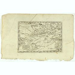
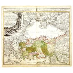
![[2 maps and one text sheet] Theatrum Belli A° MDCCXXXVII. . . / Verus Chersonesi Tauricae Seu Crimea Conspectus adjacentium item Regionem itinerisq ab Exercitu Ruthemo...](/uploads/cache/27975-250x250.jpg)
[2 maps and one text sheet] Theatrum Belli A° MDCCXXXVII. . . / Verus Chersonesi Tauricae Seu Crimea Conspectus adjacentium item Regionem itinerisq ab Exercitu Ruthemo...
[2 maps and one text sheet] Theatrum Belli A° MDCCXXXVII. . . / Verus Chersonesi Tauricae Seu Crimea Conspectus adjacentium item Regionem itinerisq ab Exercitu Ruthemo A...
- $1100 / ≈ €952
Date: Amsterdam, c. 1744
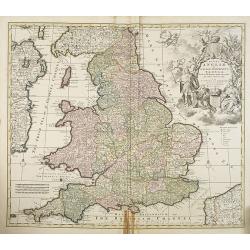
Regni Angliae et Wallae principatus Tabula, divisa in LII Regiones. . .
A detailed and decorative map of England, with an attractive uncolored title cartouche. The map is a re-issue of Carolus Allard's map. The elaborate title cartouche in th...
- $400 / ≈ €346
Date: Amsterdam c. 1744
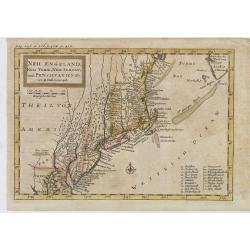
Neu Engeland Neu York, Neu Jersey und Pensilvanien & c. . .
The scarce German edition of Moll's popular and rather significant map which appeared in Oldmixon's 1708 book, Das Britische Reich in America. and then in other editions ...
Date: Lemgo, 1744
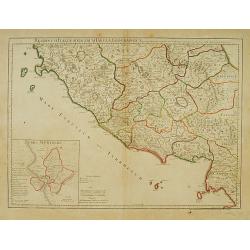
Regionum Italiae mediarum Tabula Geographica. . .
Fine historical map of central Italy with Tuscany, centered on Rome, in the south Pompeii, in the top the island of Giglio and the town Orbetello. Lower left inset plan o...
- $150 / ≈ €130
Date: Paris, 1745
Atlas van Zeevaert en Koophandel door de Geheele Weereldt.
Engraved frontispiece, title printed in red and black with engraved vignette, engraved dedication to the Dutch East India Company, 32 double-page engraved charts with con...
- $65000 / ≈ €56254
Date: Amsterdam, 1745
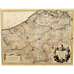
Carte du Comté de Flandre, Dressée sur differens. . .
Large, detailed map of the Flanders including the French Flemish-speaking area. Shows illustrated topography with notations about towns, roads, fortresses, abbeys, monast...
Date: Amsterdam, c. 1745
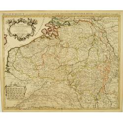
Carte Des Pays Bas Catholiques Dressée. . .
Topographically detailed map that extends from Paris to Metz and north into Holland. Details include roads and scores of villages. Two decorative cartouches: one with fig...
Date: Amsterdam, c. 1745
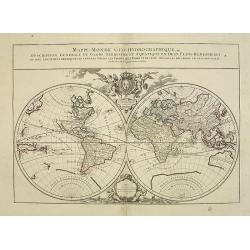
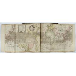
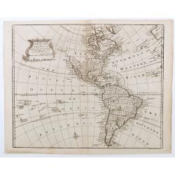
Mappe-Monde Geo-Hydrographique, ou Description Générale. . .
Large map of the world in two hemispheres, in a stereographic projection (each hemisphere 31.5 cm in diameter). California seems to be connected to the mainland, rather t...
Date: Paris, 1719, but ca. 1741-1745

Plan de la Rade de Gedda situee de la Cote d'Arabie sur la Mer Rouge.
Chart of the area around city of Gedda in the Red Sea. D'Après De Mannevillette (1707-1780) was one of Franc's first hydrographers. When the first edition of his Atlas L...
- $600 / ≈ €519
Date: Paris, 1745
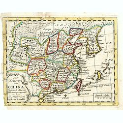
Het Keizerryk van China, volgens de Nieuwste Waarneminge opgesteld.
A scarce and uncommon miniature map of China, Korea and Taiwan. The map is of interest for the use of De Zuid Zee for the sea between Korea and Japan.
- $300 / ≈ €260
Date: Amsterdam, 1745
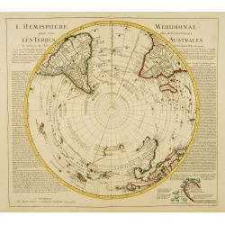
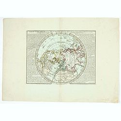
L'Hemisphere Meridional pour voir plus distinctement les Terres Australes.
Decorative map depicting from the southern pole to the Equator with good detail, and showing all the political divisions.Showing South America, southern Africa, the west ...
Date: Amsterdam, c. 1745
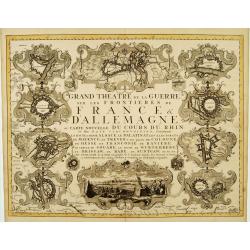
Grand Theatre de la Guerre sur les Frontieres de France & D'Allemagne..
Elegant arrangement of ten vignette views representing fortresses on or near the Rhine, including one view of a French Siège de Philipsbourg. The forts on the Rhine cons...
Date: Amsterdam, c. 1745
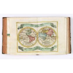
![{Title page] Introduction a la geographie, Contenant.. (2 sheets)](/uploads/cache/21495-250x250.jpg)
{Title page] Introduction a la geographie, Contenant.. (2 sheets)
In lower part title page an interesting world map in double hemisphere. The map is printed north up and is mirror imaged. Showing California as an island. French text on ...
Date: Amsterdam, c. 1745
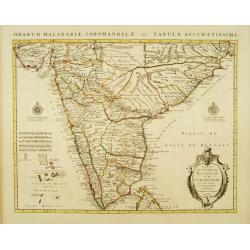
Carte des Côtes de Malabar et de Coromandel Presentée au Roy. . .
Large and attractive map of the Indian coasts of Malabar and Coromandel, embellished with title cartouche and 2 compass roses. It shows the most northern part of Ceylon.T...
- $500 / ≈ €433
Date: Amsterdam c. 1745
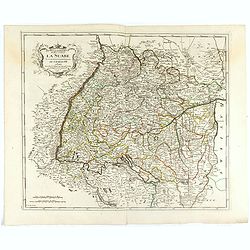
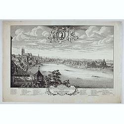
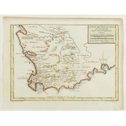
![Partie Septentrionale de la Souabe [and] Partie Meridionale de la Souabe. (2 maps)](/uploads/cache/21468-250x250.jpg)
Partie Septentrionale de la Souabe [and] Partie Meridionale de la Souabe. (2 maps)
Pair of maps forms a large, detailed view of Swabia, one of the ten circles of the Holy Roman Empire and containing some of the historically most interesting and cultural...
- $250 / ≈ €216
Date: Amsterdam c. 1745
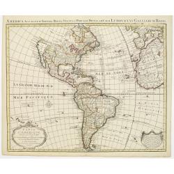
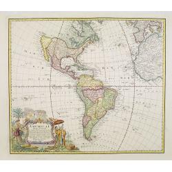
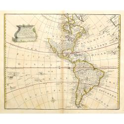
Carte d' Amerique Dressee pour l'Usage Du Roy. . .
Detailed copper-engraved map of the American continent. Decorative title cartouche with foliate garland, and embellished lettering of d' Amerique. The western parts of Af...
- $1000 / ≈ €865
Date: Amsterdam c. 1745
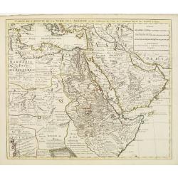
Carte de l'Egypte de la Nubie de L'Abissinie &c..
Detailed copper-engraved map of North-East Africa showing Guinea in the southwest through Ethiopia , the Red Sea to the Persian Gulf.In the northwest, Tunis through Egypt...
Date: Amsterdam, c. 1745
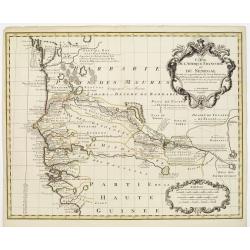
Carte de l'Afrique Françoise ou du Senegal. . .
Large map of the African West coast covering present-day Senegal and Gambia. It provides extensive detail along the Senegal River. The outline hand coloring shows the ext...
- $300 / ≈ €260
Date: Amsterdam, c. 1745
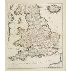
Le royaume d'Angleterre..
Fine map of England and Wales. As well as country details, including the main post roads. Le Rouge was active from 1740- till 1780 as a publisher, and was appointed engin...
- $250 / ≈ €216
Date: Paris, 1745
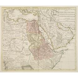
Carte de l'Egypte de la Nubie de l'Abissinie. . .
Detailed copper-engraved map of North-East Africa showing Guinea in the southwest through Ethiopia , the Red Sea to the Persian Gulf.In the northwest, Tunis through Egypt...
Date: Amsterdam, 1745
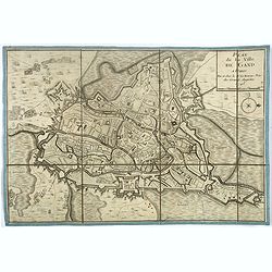
Plan de la ville de Gand. Paris, Sr. Le Rouge, 1745.
Town-plan of Ghent with its citadel, published in 1745, the year when the city was taken by the French during the War of Austrian Succession. The north is located to the ...
- $380 / ≈ €329
Date: Paris, 1745
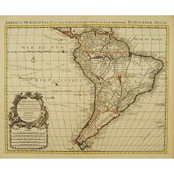
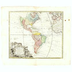
L'Amerique Meridionale Dressée sur les Observations..
Detailed map of South America prepared by De L'Isle, with fine title cartouche.The map is from a Dutch edition of De L'Isle's work entitled, Atlas Nouveau, Contenant Tout...
- $500 / ≈ €433
Date: Amsterdam c. 1745
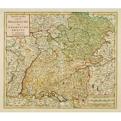
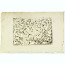
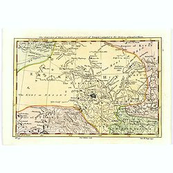
Nieuwe Kaart van de Frankische en Zwabische Kreits.
Deatailed map of the Southern part of Germany. Isaak Tirion was born in Utrecht ca. 1705. He came to Amsterdam ca. 1725. Tirion published a number of important books, m...
- $100 / ≈ €87
Date: Amsterdam, 1745
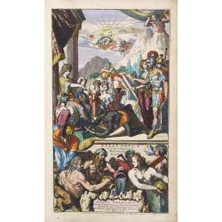
Atlas Novus ad Usum Serenissimi Burgundiae Ducis.
Soldiers, savages and other individuals are shown approaching a queen seated on her throne. In the upper right corner, Atlas is shown holding up the world. In the sky, a ...
- $800 / ≈ €692
Date: Amsterdam c. 1745
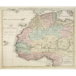
Carte de la Barbarie de la Nigritie et de la Guinée..
Showing the imaginary island of ''Borondon'' or Saint Brendan's Island, also known as Saint Brendan's Isle, supposedly situated in the North Atlantic somewhere west of No...
Date: Amsterdam c. 1745
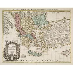
Carte de la Grece dressée sur un grand nombre de memoires. . .
Detailed copper-engraved map of Greece with its neighboring countries, including southern Italy and part of Cyprus. Relief shown pictorially. With large decorative title ...
Date: Amsterdam c. 1745
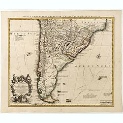
Carte du Paraguay, du Chili, du Detroit de Magellan &c.
Large handsome map of the southern part of the continent with good interior detail for the period. The route of 18th century explorations are shown along with notations c...
Date: Amsterdam c. 1745
Prospect der Statt Basel von der St Alban Vorstraat - Vu¨e et perspective de la ville de Bâle du côté du Faubourg de St Albon.
Very decorative view of Basel, after a design by Emanuel Büchel and engraved by Johann Martin Weiss. Numbered 'No.1' in the bottom right, from a rare series of 4 sheets.
Date: Basle, ca. 1745
Prospect der Statt Basel von Seiten der Schlösser - Vuë et Perspective de la Ville de Bale du coté des Chateaux de Gundeldingue.
Very decorative view looking towards Basel from the castle at Gundeldingen, on a hill to the south. Accompanied at the bottom by a cartouche containing the arms of the ci...
Date: Basle, ca. 1745
Prospect der Statt Basel von Seiten der Kleinen Statt - Vüe et Perspective de la Ville de Bâle du côté de la petite Ville.
Very decorative view of Basle, after a design by Emanuel Büchel and engraved by Johann Martin Weiss. The legend inscribed under the engraving, numbered from 1 to 10, des...
Date: Basle, 1745
![[Lot of 3 maps] Carte de la Souveraineté de NEUCHATEL et VALLANGIN. Plus Mercator's and Blaeu's maps of the Wiflispurgergou]](/uploads/cache/18600-250x250.jpg)
[Lot of 3 maps] Carte de la Souveraineté de NEUCHATEL et VALLANGIN. Plus Mercator's and Blaeu's maps of the Wiflispurgergou]
Map of the lake of Neuchatel by Covens & Mortier. After the death of the widow of Pieter Mortier in 1719, the firm continued till 1778 as Covens & Mortier. They...
- $350 / ≈ €303
Date: Amsterdam, c. 1745
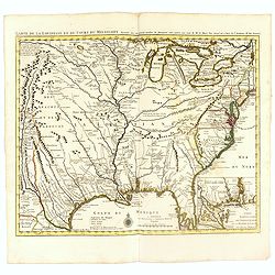
Carte de la Louisiane et du Cours du Mississipi Dressée sur un grand nombre de Memoires..
Covens & Mortier's issue of Delisle's influential map of the French possession of Louisiana. Updated to include New Orleans. When originally published in 1718, it was...
- $2400 / ≈ €2077
Date: Amsterdam, c. 1745
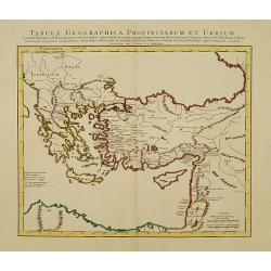
Tabula Geographica Provinciarum et Urbium Colonia Romana. .
Covens and Mortier's Map of the Roman World is a copperplate engraving based on an earlier map by Guillelmo De L'Isle (1675-1726), Geographer to the King of France.Engrav...
Date: Amsterdam c. 1745
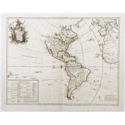
L'Amerique Meridionale Dressée sur les Observations . . .
Detailed map of South America prepared by De L'Isle, with fine title cartouche.
Date: Amsterdam, ca. 1745

Itinera Varia Auctoris.
From A Natural History of Uncommon Birds, and of some other rare and undescribed Animals, Quadrupeds, Reptiles, fishes, insects, &c.. The map shows Edwards' journeys ...
- $300 / ≈ €260
Date: London, 1746
Planiglobii Terrestris Mappa Universalis.. - Mappe-Monde qui represente les deux Hemispheres. . .
Word map in double hemisphere. In center two smaller hemispheres of the north and south pole are shown. Two interesting diagrams depict the earth as it would be seen from...
Date: Nuremberg, 1746

Le Théâtre du monde dédié au roi contenant les cartes générales et particulières des royaumes et états qui le composent.
The present example of the Théâtre du monde is the reissue of 1746 by Jean-Baptiste Nolin II. This scarce atlas is illustrated with 123 maps mostly double-page, in orig...
Date: Paris, 1746
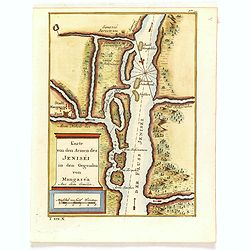
Karte von den Armen des Jeniséi in den Gegenden von Mangaséa Aus dem Gmélin.
Attractive and detailed map of Jenisëi River with the town of Mangasea in Siberia. The composition is nicely balanced with a large title and scale cartouche.
- $75 / ≈ €65
Date: Leipzig, Arkstee & Merkus, 1746
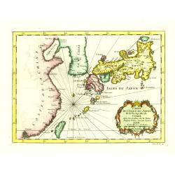
Carte des Isles du Japon et la Presqu'Isle de Coree. . .
A fine map of the islands of Japan, including Korea, Taiwan and the coast of China till Macao.Embellished with fine baroque decorations. Bellin influenced other cartograp...
Date: Paris, 1746
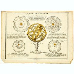
Le Nom de Systeme..
Showing the solar systems according to Copernicus, Ptolomy, Ticho Brahé and a composition. In the center a armillary sphere on a decorative base.
- $100 / ≈ €87
Date: Paris, 1746
Das Kaiserthum China zur allgemeinen Historie der Reisen - entworfen von N. Bellin Ing. De la Mar. 1748.
Attractive and detailed map of China and Korea. The map is of interest for the use of Das Meer von Korea for the coast along the east coast of Korea. The composition is n...
- $500 / ≈ €433
Date: Leipzig, Arkstee & Merkus, 1746
Carte des lieux où les différentes longueurs du pendule à secondes ont été observées . . .
World map. Published in Buache's "Considérations géographiques et physiques", one of his most important and original cartographic works.The map projects the c...
- $500 / ≈ €433
Date: Paris, 1746
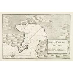
Plan du Port de Cartagene.
Sea chart of the Port of Cartagene. Marked with navigational notes.From the rare chart book by Jacques Ayrouard: Recueil de plusieurs Ports de la Mer Méditerranée...
- $200 / ≈ €173
Date: Marseille, 1732-1746
![Calmuk Tartars from Isbrant Ides [ together with] Tartars from Isbr. Ides.](/uploads/cache/36951-250x250.jpg)
Calmuk Tartars from Isbrant Ides [ together with] Tartars from Isbr. Ides.
Two engravings on one sheet, taken from "A New General Collection of Voyages and Travels", printed for Thomas Astley. Engraved by Thomas Kitchin and N.Parr afte...
- $40 / ≈ €35
Date: London, 1746
![Tartars of Koko Nor [ together with] Nothern Tartary Woman at Lafsa.](/uploads/cache/36952-250x250.jpg)
Tartars of Koko Nor [ together with] Nothern Tartary Woman at Lafsa.
Two engravings on one sheet, taken from "A New General Collection of Voyages and Travels", printed for Thomas Astley. Engraved by Thomas Kitchin and N.Parr afte...
- $45 / ≈ €39
Date: London, 1746
Americae Mappa generalis Secundum legimitas projectionis Stereiographiae regulas. . . MDCCXXXXVI
Johann Baptist Homann's well-engraved second map of America has a large decorative cartouche. Detailed map of the western hemisphere.The interior of North America has new...
- $600 / ≈ €519
Date: Nuremberg, 1746
Americae Mappa generalis.
Johann Baptist Homann's well-engraved second map of America has a large decorative cartouche. Detailed map of the western hemisphere.The interior of North America has new...
Date: Nuremberg, 1746
![Uzbek Tartars [ together with] Eastern Tartars, from Nieuhof.](/uploads/cache/36953-250x250.jpg)
Uzbek Tartars [ together with] Eastern Tartars, from Nieuhof.
Two engravings on one sheet, taken from "A New General Collection of Voyages and Travels", printed for Thomas Astley. Engraved by Thomas Kitchin and N.Parr afte...
- $50 / ≈ €43
Date: London, 1746
L'Amerique suivant Le R.P.Charlevoix..
Interesting map of the Western Hemisphere. With decorative rococo cartouche and lower left an inset with the foreign possessions in America.Mentioning but no depiction of...
Date: Paris, 1746

Plan du Golfe et des Caps de St. Tropez. par Jacques Ayrouard . . .
Large plan of the harbour St. Tropez. Decorated with a large compass rose.From the rare chart book by Jacques Ayrouard: "Recueil de plusieurs plans des ports et rade...
Date: Marseille, 1732-1746
Carte du globe terrestre où les terres de l'hémisphère méridl sont supposées être vues à travers celles de l'hémisphère septentl.
Important single hemisphere world map prepared by Buache's with Sea of the West. Published in Buache's "Considérations géographiques et physiques", one of his...
- $500 / ≈ €433
Date: Paris, 1746
A Map of Western Tartary Drawn from the Survey of the Jesuits and Mr. Kyrillow's Map of the Russian Empire.
Uncommon map of the Gobi Desert and the eastern portion of the Silk Route region by Thomas Kitchin. Covers from Lake Baikal in the north as far south as Beijing, east to ...
- $110 / ≈ €95
Date: London, 1745-1747
A Map of Little Bochara, and the Adjacent Countrys Drawn from the Survey of the Jesuits and Mr. Kyrillows Map of the Russian Empire.
An uncommon map of the Gobi Desert and Bochara region. Engraved by Thomas Kitchin - with his signature in the lower bottom.From Astley, Thomas, "A New General Collec...
- $110 / ≈ €95
Date: London, 1745-1747
A new general map of America drawn from several..
Extremely faint strip of age toning on part of the centerfold, otherwise fine condition. The Pacific Northwest is left open with the note Parts Undiscovered. The coastlin...
- $500 / ≈ €433
Date: London, 1747
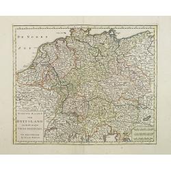
Nieuwe Kaart van Duitsland..
Detailed map of Germany, including The Netherlands, Belgium, Luxembourg, Switzerland and Austria. Isaac Tirion was born in Utrecht ca. 1705. He came to Amsterdam ca. 1725...
- $120 / ≈ €104
Date: Amsterdam, 1747
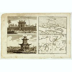
Chinese Temples. Sin-Ko-Tsyen. Canton, Sancian Isle. Ma-Kao.
An attractive print divided into four areas, two depicting Chinese temples and the other two with maps of the city of Canton, the island of Sancian and the island of Ma-K...
- $75 / ≈ €65
Date: London, 1745-1747
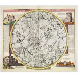
Hemisphaerium Coeli Australe in quo Fixarum. . .
Magnificent celestial chart drawn by the famous scientist Johann Gabriel Doppelmayr.Large circular charts of the southern hemisphere constellation, with decorative vignet...
- $1800 / ≈ €1558
Date: Nuremberg, 1747
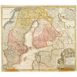
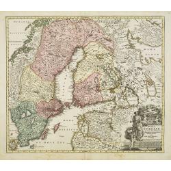
Regni Sueciae. . .
Johann Baptist Homann's well-engraved map has a large decorative cartouche. Detailed map of Sweden and Finland.Johann Baptist Homann (1663-1724) was a German engraver and...
Date: Nuremberg, 1747
Carte des Isles de Java, Sumatra, Borneo. . . Malaca et Banca. . . / Kaart van de Eilanden van Java. . .
Dutch edition of this map of Indonesia prepared by N. Bellin and published by Pierre d'Hondt in Amsterdam. Jaques Nicolas Bellin (1703-1772) was one of the most important...
- $400 / ≈ €346
Date: Amsterdam, 1747
The Empire of Hya (including grear part of Tangul)...
Uncommon map of the Gobi Desert.Engraved by Thomas Kitchin - with his signature in lower bottom.From Astley, Thomas, "A New General Collections of Voyages and Travel...
- $100 / ≈ €87
Date: London, 1745-1747
Regni Sueciae in omnes suas Subjacentes Provincias accurate divisi Tabula Generalis. . .
Johann Baptist Homann's well-engraved map has a large decorative cartouche. Detailed map of Scandinavia, the Baltic Sea, Lithuania, Latvia, Estonia, Curlandia, etc.Johann...
Date: Nuremberg, 1747
A new general map of America drawn from several…
The Pacific Northwest is left open with the note "Parts Undiscovered." The coastline stops around the area of Alaska and notes "The Supposed Straits of Ann...
Date: London, Bowen, 1747
A New and Accurate Map of the Whole Russian Empire as contained both in Europe and Asia. . .
Detailed map of Russia, from the Sea of Anadyr, Sea of Kamchatka and the Kuril Islands to St.Petersburg. Also includes Tibet, Korea and part of China, with the Great Wall...
- $200 / ≈ €173
Date: London, c. 1747
A Map of the Rout which Hannibal took through Gaul & over the Alpes into Italy.
A map showing the (clear) route the North African, Carthaginian General Hannibal took to get from Spain to northern Italy, via France and the Alps. Ancient, Latin names a...
- $40 / ≈ €35
Date: London, 1747
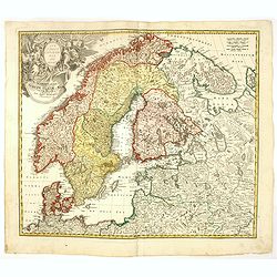
Scandinavia complectens Sueciae, Daniae & Norvegia. . .
Johann Baptist Homann's well-engraved map has a large decorative cartouche. Detailed map of Scandinavia.Johann Baptist Homann (1663-1724) was a German engraver and publis...
- $350 / ≈ €303
Date: Nuremberg, 1747
Afbeelding van all de Landen gelegen tusschen de Middellandsche, Zwarte, Caspische, Persische en Rode Zeën.
A map of the Near East, with an oversized Cyprus. From a Dutch bible published by Nicolaas Goetzee. Willem Albert Bachiene (1712-1783), Dutch geographer in Maastricht. Mo...
- $300 / ≈ €260
Date: Gorichem, Nicolaas Goetzee, 1748
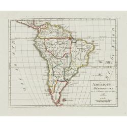
Amérique Méridionale.
Nice small map of South America. Dated 1748. From Atlas Portatif Universel, by Robert de Vaugondy.Page 105 outside border top right. Mary Sponberg Pedley does not mention...
- $75 / ≈ €65
Date: Paris, later than 1748
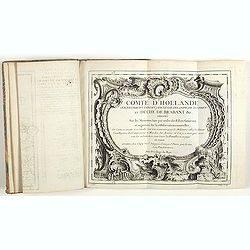
Comté d'Hollande, seigneurie d'Utrecht, comtés de Zelande, de Zutphen et duché de Brabant &c. Dressés sur les Mémoires faits par ordre des Estats Généraux et augmentés sur les Observations nouvelles.
Pocket atlas illustrated with a folded engraved title, a general map and 34 folded maps, including maps of the Netherlands, Belgium and parts of Germany.Provenance : Ex-l...
- $2400 / ≈ €2077
Date: Paris, Crépy, ca. 1748
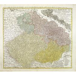
Regni Bohemiae, Duc. Silesiae, Marchionatuum Moraviae et Lusatiae. . .
Johann Baptist Homann's well-engraved map including the towns of Prague, Poznan/ Loda, Wroclaw, etc.This example was printed from plate A (1st of 3), which can be identif...
- $200 / ≈ €173
Date: Nuremberg, ca. 1748
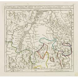
VI. Carte des Confins de l'Etat de Gênes où sont Novi, Gavi, et Ottagio..
Detailed small map encompassing the part of Piedmont between Alessandria, Tortona and Novi Ligure.Relief shown pictorially. From Atlas Portatif Universel, by Robert de Va...
- $150 / ≈ €130
Date: Paris, later than 1748
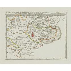
V. Carte du Brabant ou se trouvét les Mair.s d'Herentals.. Hochstraten.
Nice small map illustrating the northeastern part of the Flemish region. Centered on Turnhout.From Atlas Portatif Universel, by Robert de Vaugondy. Unrecorded state with ...
- $50 / ≈ €43
Date: Paris, later than 1748
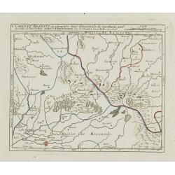
VI. Carte du Duché de Limbourg où sont les environs de Limbourg.
Attractive small map showing part of the Wallon region, centered on Limburg. Dated 1748. From Atlas Portatif Universel, by Robert de Vaugondy.Page 15f outside border top ...
- $45 / ≈ €39
Date: Paris, 1748
Der curiose und ... Nüssliche Dollmetscher..
Rare atlas and containing geographical descriptions of all continents. Illustrated with 30 very finely engraved and beautifully colored maps in attractive original strong...
- $6000 / ≈ €5193
Date: Augsburg, 1748
Carte de L'Asie Mineure ou de la Natolie et du Pont Euxin
Johann Baptist Homann's well-engraved map of Asia Minor, the Black Sea ( Ponti Euxin), Crimea and a part of Greece. Depicts Turkey and the area surrounding the Black Sea ...
Date: Nuremberg, ca. 1748
Le Pays des Hottentots aux environs du Cap de Bonne Espérance. . .
A good engraved map of Cape of Good Hope. The geographical features are typical with somewhat exaggerated bays, inlets and prominent mountain ranges. The west coast of th...
Date: Paris, 1748
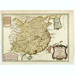
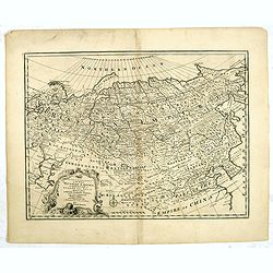
L'Empire de la Chine.
A fine map of China, Korea and Taiwan.Jacques Nicholas Bellin (1703-1772) was one of the most important and proficient French cartographers of the mid-eighteenth century....
- $450 / ≈ €389
Date: Paris, 1748
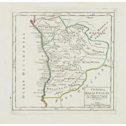
Congo ou Basse Guinée.
Nice small map showing a long stretch of the central Africa west coast and its hinterland. Centered on Luanda.From Atlas Portatif Universel, by Robert de Vaugondy. "...
- $75 / ≈ €65
Date: Paris, later than 1748
No title (Carte générale de l'empire de Russie).
The right hand sheet of a map of the Empire of Peter the Great.This important map is based on maps from the Bering expedition and on De L'Isle's Akademiia nauk Atlas of 1...
- $800 / ≈ €692
Date: Amsterdam, ca.1748
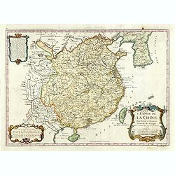
L'Empire de la Chine. . .
A fine map of China, Korea and Taiwan.Jacques Nicholas Bellin (1703-1772) was one of the most important and proficient French cartographers of the mid-eighteenth century....
- $450 / ≈ €389
Date: Paris, 1748