Subscribe to be notified if similar examples become available.
Mappe-Monde Geo-Hydrographique, ou Description Générale. . . |
||||||||||||||||||||
|
||||||||||||||||||||
|
|
||||||||||||||||||||
|
Selling price: $ Please login to see price!
Sold Missed this item! Add your name to our mailing list and be the first to get notified about our newly added listings. . |
My Collection + - Save and collect this or any of your favorite items in one place.
If you want to save the items permanently, please sign in or create account first.
Watchers:
3
|
|||||||||||||||||||
Description
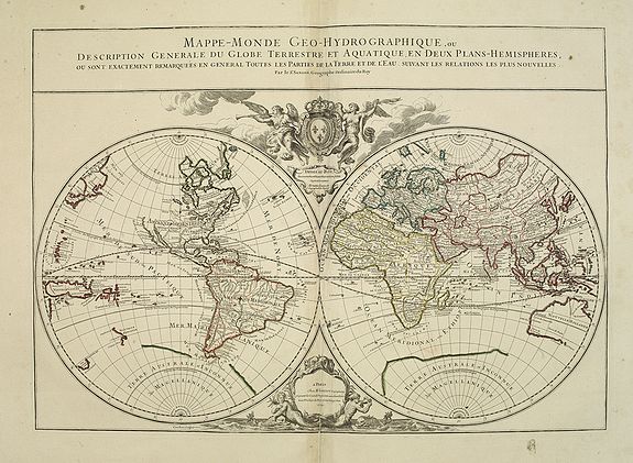
Large map of the world in two hemispheres, in a stereographic projection (each hemisphere 31.5 cm in diameter). California seems to be connected to the mainland, rather than appearing as an island, but the placement of the lettering slightly obscures the connection.
The map in its first state, dated, 169 , and dedicated to King Louis XIV, appears in (Antoine-)Hubert Jaillot's 1695 Atlas François. It was engraved by (Louis) Cordier. Shirley mentions states of the plate dated 1700 and 1706, but gives no locations and Pastoureau still records the,169, state in a copy of the 1700 edition of Jaillot's atlas.
With title in a panel across the head, imprint in a decorative cartouche with mermaids and dolphins at the foot, and dedication to the (by this time deceased) King Louis XIV in a cartouche above, under the royal arms supported by 2 angels, 1 with a trumpet.
In the lower cartouche the date 1719. Jaillot and his heirs continued to publish his atlas with the 1700 date on the title page for many years, and Pastoureau records copies with the Mappe-Monde, printed from the plate in the 1706 and the present 1719 states.
The original dedication to Louis XIV had conveniently said simply "Dedié au Roy" so after he died in 1715, leaving the government in the hands of the regents until Louis XV came of age in 1723, the revisers of the map let the dedication to the unnamed king stand.
The plate was apparently not revised again after 1719, but Jaillot's heirs continued to use it so that the map appears in their atlases for twenty years into the reign of Louis XV.
The literature records no copies of Jaillot's atlas later than 1738, but that date is based on the engraved date in one of the maps, so some copies recorded under that date may be somewhat later. The present copy of the "Mappe-Monde" is watermarked ,J (or I) [pillar topped by ,T,] DUPVY MOYENAUVERGNE 1742, = chaplet (cf. Heawood 238), and was formally bound with other maps from Jaillot's atlas with similar 1742 Dupuy watermarks, as well as other maps (with different watermarks) probably issued by Gilles Robert in the years 1742-1745.
From 1731 Jaillot's firm was in the hands of his grandson Bernard-Antoine (d. 1749). A good copy of an attractively decorated map of the world.
Reference: Cat. Nat. Mar. Mus. III, 240, map 70. Pastoureau, Jaillot II C-D, G & I map 1 (cf. map 1 in II A, E & F). Phillips & LeGear 534, map, this state not mentioned in Shirley (cf. 569). Lexikon Gesch. Kartographie, pp. 353-354 & 699-701.
FAQ - Guarantee - Shipping
Buying in the BuyNow Gallery
This item is available for immediate purchase when a "Add to Cart" or "Inquire Now" button is shown.
Items are sold in the EU margin scheme
Payments are accepted in Euros or US Dollars.
Authenticity Guarantee
 We provide professional descriptions, condition report (based on 45 years experience in the map business)
Paulus Swaen warrants the authenticity of our items and a certificate of authenticity is provided for each acquired lot.
Condition and Coloring
We indicate the condition of each item and use our unnique HiBCoR grading system in which four key items determine a map's value: Historical Importance, Beauty, Condition/Coloring and Rarity.
Color Key
We offer many maps in their original black and white condition. We do not systematically color-up maps to make them more sellable to the general public or buyer.
Copper engraved or wood block maps are always hand colored. Maps were initially colored for aesthetic reasons and to improve readability. Nowadays, it is becoming a challenge to find maps in their original colors and are therefor more valuable.
We use the following color keys in our catalog:
Original colors; mean that the colors have been applied around the time the map was issued.
Original o/l colors; means the map has only the borders colored at the time of publication.
Colored; If the colors are applied recently or at the end of the 20th century.
Read more about coloring of maps [+]
Shipping fee
A flat shipping fee of $ 30 is added to each shipment by DHL within Europe and North America. This covers : International Priority shipping, Packing and Insurance (up to the invoice amount).
Shipments to Asia are $ 40 and rest of the world $50
We charge only one shipping fee when you have been successful on multiple items or when you want to combine gallery and auction purchases.
Read more about invoicing and shipping
FAQ
Please have a look for more information about buying in the BuyNow gallery
Many answers are likely to find in the general help section.
My Collection+
![]()
With My Collection+ you can collect all your favorite items in one place. It is free, and anyone can create his or her virtual collection.
Unless you are logged in, the item is only saved for this session. You have to be registed and logged-in if you want to save this item permanently to My Collection+.
Read More[+]
Register here, it is free and you do not need a credit card.
Add this item to
My Collection+
or click the following link to see My Collection+.
| Digital Image Download | |
|
Paulus Swaen maintains an archive of most of our high-resolution rare maps, prints, posters and medieval manuscript scans. We make them freely available for download and study. Read more about free image download |
Click the image for a free small image download. |
In accordance with the EU Consumer Rights Directive and habitually reside in the European Union you have the right to cancel the contract for the purchase of a lot, without giving any reason.
The cancellation period will expire 14 calendar days from the day after the date on which you or a third party (other than the carrier and indicated by you) acquires, physical possession of the lot. To exercise the right to cancel you must inform Paulus Swaen Inc, of your decision to cancel this contract by a clear statement (e.g. a letter sent by post, or e-mail (amsterdam@swaen.com).
To meet the cancellation deadline, it is sufficient for you to send your communication concerning your exercise of the right to cancel before the cancellation period has expired.
