Browse Listings
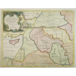
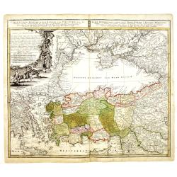
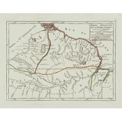
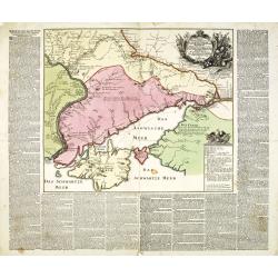
Afbeelding van all de Landen gelegen tusschen de Middellandsche, Zwarte, Caspische, Persische en Rode Zeën.
A map of the Near East, with an oversized Cyprus. From a Dutch bible published by Nicolaas Goetzee. Willem Albert Bachiene (1712-1783), Dutch geographer in Maastricht. Mo...
- $300 / ≈ €260
Date: Gorichem, Nicolaas Goetzee, 1748

Christianus Henricus Heineken . . .
Portrait of Carl Heinrich, Baron von Heineken, as a child, whole-length, standing on a room with books on the right, a skeleton, and a large globe on the left, wearing a ...
Date: Nuremberg, 1724-1748
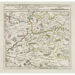
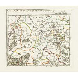
V. Carte des C.tes de Haynaut et de Namur. . .
Attractive small map illustrating part of the Walloon Region, centered on Charleroi. From Atlas Portatif Universel, by Robert de Vaugondy.Unrecorded state with erased dat...
- $30 / ≈ €26
Date: Paris, after 1748
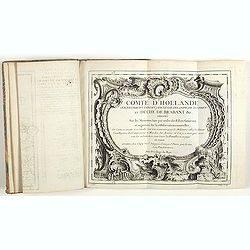
Comté d'Hollande, seigneurie d'Utrecht, comtés de Zelande, de Zutphen et duché de Brabant &c. Dressés sur les Mémoires faits par ordre des Estats Généraux et augmentés sur les Observations nouvelles.
Pocket atlas illustrated with a folded engraved title, a general map and 34 folded maps, including maps of the Netherlands, Belgium and parts of Germany.Provenance : Ex-l...
- $2400 / ≈ €2077
Date: Paris, Crépy, ca. 1748
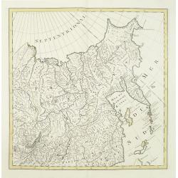
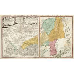
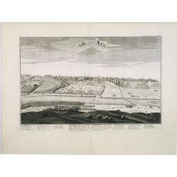
No title (Carte générale de l'empire de Russie).
The right hand sheet of a map of the Empire of Peter the Great.This important map is based on maps from the Bering expedition and on De L'Isle's Akademiia nauk Atlas of 1...
- $800 / ≈ €692
Date: Amsterdam, ca.1748
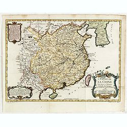
L'Empire de la Chine. . .
A fine map of China, Korea and Taiwan.Jacques Nicholas Bellin (1703-1772) was one of the most important and proficient French cartographers of the mid-eighteenth century....
- $450 / ≈ €389
Date: Paris, 1748
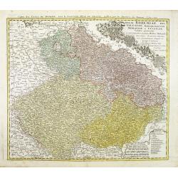
Regni Bohemiae, Duc. Silesiae, Marchionatuum Moraviae et Lusatiae. . .
Johann Baptist Homann's well-engraved map including the towns of Prague, Poznan/ Loda, Wroclaw, etc.This example was printed from plate A (1st of 3), which can be identif...
- $200 / ≈ €173
Date: Nuremberg, ca. 1748
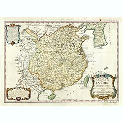
L'Empire de la Chine.
A fine map of China, Korea and Taiwan.Jacques Nicholas Bellin (1703-1772) was one of the most important and proficient French cartographers of the mid-eighteenth century....
- $450 / ≈ €389
Date: Paris, 1748
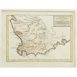
Le Pays des Hottentots aux environs du Cap de Bonne Espérance. . .
A good engraved map of Cape of Good Hope. The geographical features are typical with somewhat exaggerated bays, inlets and prominent mountain ranges. The west coast of th...
Date: Paris, 1748
Carte de L'Asie Mineure ou de la Natolie et du Pont Euxin
Johann Baptist Homann's well-engraved map of Asia Minor, the Black Sea ( Ponti Euxin), Crimea and a part of Greece. Depicts Turkey and the area surrounding the Black Sea ...
Date: Nuremberg, ca. 1748
Der curiose und ... Nüssliche Dollmetscher..
Rare atlas and containing geographical descriptions of all continents. Illustrated with 30 very finely engraved and beautifully colored maps in attractive original strong...
- $6000 / ≈ €5193
Date: Augsburg, 1748
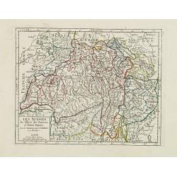
Les Suisses, les Alliés des Suisses et leurs Sujets.
Small detailed map of Switzerland. From Atlas Portatif Universel, by Robert de Vaugondy.Unrecorded state with erased date. Page 31 outside border top right. Mary Sponberg...
Date: Paris, later than 1749
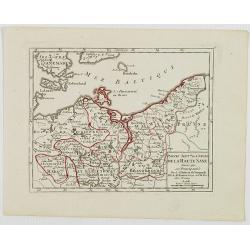
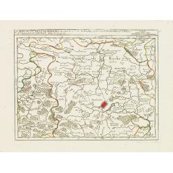
Partie Sept.le du Cercle de la Haute Saxe divisé par ses Principautés.
Small detailed map of the northeastern part of Germany, with Berlin at the bottom. Including part of Poland. From Atlas Portatif Universel, by Robert de Vaugondy.Unrecord...
- $75 / ≈ €65
Date: Paris, later than 1749
Partie Orientale de la Terre Ferme ou l'on trouve la Guiane.
Nice small map encompassing a large area between the Orinoco and the River Amazon.From Atlas Portatif Universel, by Robert de Vaugondy.Page 107 outside border top right. ...
- $75 / ≈ €65
Date: Paris, later than 1749
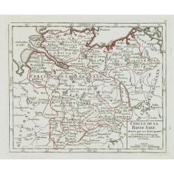
Cercle de la Basse Saxe, divisée par ses Principautés.
Small detailed map of the northern part of Germany. From Atlas Portatif Universel, by Robert de Vaugondy.Unrecorded state with erased date. Page 22 outside border top rig...
- $50 / ≈ €43
Date: Paris, later than 1749
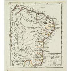
Terre de Sainte Croix, nommée à présent Bresil.
Detailed small map showing most part of the Brazilian seacoasts, from the mouth of the Amazon River as far as the island of Sao Sebastiao.From Atlas Portatif Universel, b...
- $75 / ≈ €65
Date: Paris, later than 1749
Partie Orientale de la Haute Guinée.
Nice small map centered on the Gulf of Guinea. Showing Sao Tomé and Principe. From Atlas Portatif Universel, by Robert de Vaugondy. "80" outside border top rig...
- $75 / ≈ €65
Date: Paris, later than 1749
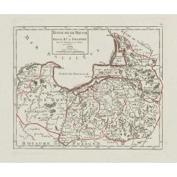
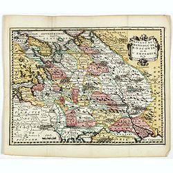
Royaume de Prusse et Prusse Rle. ou Polonoise.
On the left is Pomerania and the Desert of Waldow. At the top of the map is Memel and Samland. On the right side is the Biss River and Kautten. In the center of the map i...
- $125 / ≈ €108
Date: Paris, later than 1749
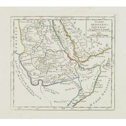
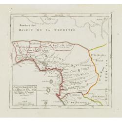
Nubie Abissinie et Cote d'Ajan.
Charming small map showing the Horn of Africa. Included are part of present-day Yemen and the coastline of Saudi Arabia along the Red Sea.From Atlas Portatif Universel, b...
- $100 / ≈ €87
Date: Paris, 1749
Afbeeldinge der Oude Waereld; Benevens Derzelver Verdeling Onder de Nakomelingen Noachs.
An interesting and uncommon map of the 'Old World' showing the continents of Europe, Asia, and Africa divided among Noah's sons. Engraved by Jan van Jagen and published i...
Date: Amsterdam, 1749
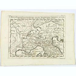
A Map of Gallia, Cisalpina, Liguria and the Neighbouring Countries.
A map of eastern France, Provence, northern Italy, then to Tuscany, whilst also showing northern Switzerland and Bavaria in Roman times. Showing Roman Provinces, a mileag...
- $50 / ≈ €43
Date: London, ca 1749
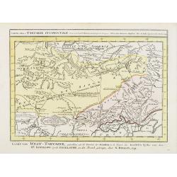
Carte de la Tartarie Occidentale.
Uncommon issue of this finely engraved map shows China's capital city of Peking, inland from the Gulf of Lyau-tong.The map locates in northeastern China to the border of ...
- $100 / ≈ €87
Date: Amsterdam, 1749
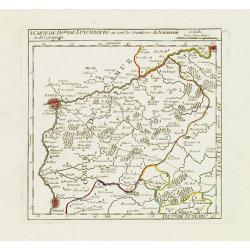
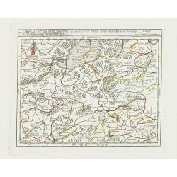
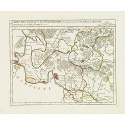
I. Carte du D.ché de Luxembourg ou sont les Frontieres du Namurois et du Lyegeois.
Charming small map representing part of the Walloon Region, delimited by the towns of Namur, Huy, Dinant and Ciney.From Atlas Portatif Universel, by Robert de Vaugondy. E...
Date: Paris, later than 1749
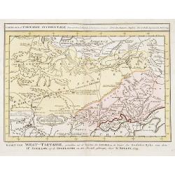
Carte de la Tartarie Occidentale.
Uncommon issue of this finely engraved map showing China's capital city of Peking inland from the Gulf of Lyau-tong. The map locates northeastern China to the border of R...
- $150 / ≈ €130
Date: Amsterdam, 1749
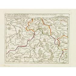
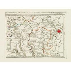
II. Carte du D.é de Luxembourg.. Seign.rie de Lyege &c.
Charming small map representing part of the Walloon Region, south to Liège. From Atlas Portatif Universel, by Robert de Vaugondy.Edited by : "Au dépôt de Géograp...
Date: Paris, later than 1749
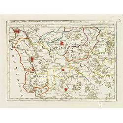
III. Carte du D.hé de Luxembourg.. Cronenburg &c.
Charming small map representing part of the Walloon Region, southeast to Limburg. From Atlas Portatif Universel, by Robert de Vaugondy.Edited by : "Au dépôt de Gé...
Date: Paris, later than 1749
Estats du Grand duc de Moscovie ou de l'Empereur de la Russie Blanche.
Uncommon map of European Russia centered on Muscovy. Charming title cartouche in upper right corner.
- $300 / ≈ €260
Date: Amsterdam, ca 1749
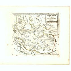
Royaume de Perse Par le Sr. Robert de Vaugondy fils de Mr. Robert Geog. Ord du Roi avec Privilege 1749.
Small detailed map of Persia. From Atlas Portatif Universel, by Robert de Vaugondy.Page 163 outside border top right. First and only state.
Date: Paris, 1749
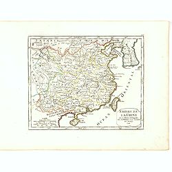
Empire de la Chine Par le Sr. Robert de Vaugondy fils de Mr. Robert Geog. Ord du Roi avec Privilege 1749.
Small detailed map of China, and Corea, including Taiwan. From Atlas Portatif Universel, by Robert de Vaugondy.Page 165 outside border top right. First and only state.The...
Date: Paris, 1749
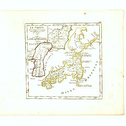
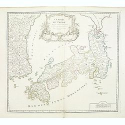
Le Japon Par le Sr. Robert de Vaugondy fils de Mr. Robert Geog. Ord du Roi avec Privilege 1749.
Small detailed map of Japan and Korea. From Atlas Portatif Universel, by Robert de Vaugondy.Page 168 outside border top right. First state. The map is of interest for the...
Date: Paris, 1749
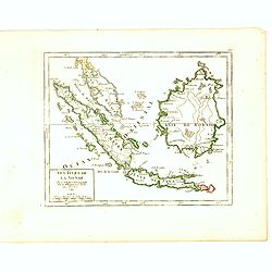
Les Isles de la Sonde Par le Sr. Robert de Vaugondy fils de Mr. Robert Geog. Ord du Roi avec Privilege 1749.
Small detailed map of of South East Asia, including Malaysian Peninsular with Singapore. From Atlas Portatif Universel, by Robert de Vaugondy.Page 170 outside border top...
Date: Paris, 1749
IV. Carte du Duché de Luxembourg où sont les Seign.ries de Lompré..
Charming small map representing part of Luxembourg, the southernmost province of Wallonia and of Belgium.From Atlas Portatif Universel, by Robert de Vaugondy. Edited by :...
Date: Paris, later than 1749
V. Carte du D.hé de Luxembourg.. dans le Lyegeois.
Charming small map representing part of Luxembourg, the southernmost province of Wallonia and of Belgium. Centered on Bastogne.From Atlas Portatif Universel, by Robert de...
Date: Paris, later than 1749
VII. Carte des Frontieres du Luxembourg.. Yvoix &c.
Detailed small map showing an area straddling the border between France and Belgium.From Atlas Portatif Universel, by Robert de Vaugondy. Edited by : "Au dépôt de ...
Date: Paris, later than 1749
IX. Carte du D.ché du Luxembourg.. Diekirch &c.
Charming small map representing the area between Luxembourg and Trier. From Atlas Portatif Universel, by Robert de Vaugondy.Edited by : "Au dépôt de Géographie, R...
Date: Paris, later than 1749
X. Carte du D.ché de Luxembourg.. Jametz &c.
Nice small map encompassing the northwestern part of Lorraine. Showing Mouzon, Stenay, Montmedy..From Atlas Portatif Universel, by Robert de Vaugondy. Edited by : "A...
Date: Paris, later than 1749
![[IX.] Carte du Brabant ou sont les Mairies de Roo, de Nivelle, de Hulpen, et de Geneppe.](/uploads/cache/24689-250x250.jpg)
[IX.] Carte du Brabant ou sont les Mairies de Roo, de Nivelle, de Hulpen, et de Geneppe.
Nice small map straddling the Flemish and the Walloon regions. It shows Halle, Nivelles, La Hulpe, Overijse, Genappe, etc.From Atlas Portatif Universel, by Robert de Vaug...
Date: Paris, later than 1749

Partie du Mexique ou de la Nouvelle Espagne Où se trouve l'Audience de Guatimala.
Nice small map of Central America, extending from the Yucatán Peninsula to Panama. From Atlas Portatif Universel, by Robert de Vaugondy.From Atlas Portatif Universel, by...
Date: Paris, later than 1749
Tartariae Sinensis mappa geographica ex Tabulis specialibus RRPP Iesuitarun nec non Relationibus R.P. Gerbillon / per Dom d'Anville, . . . primum A° 1732 nunc se Nunc secundum LL. projectionis . . . descripta per Tobiam Mayer
A very attractive map of Korea and Manchuria on the mainland and two islands of 'Ezo' and Sakhalin, prepared by Jean-Baptiste Bourguignon d'Anville (1697-1782) and Johann...
- $750 / ≈ €649
Date: Nuremberg, 1749

1. Seigneure Delassa tirés de Grueber. 2. Trophée à l'honneur du Grand Lama. (Tibet).
Fanciful European depiction of people from Tibet and Lhassa. A somewhat larger image appeared in "Abbe A.F. Prévost, Histoire Generale des Voyages".
Date: Paris, ca. 1750
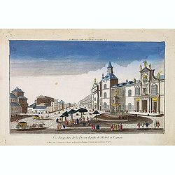
Vue perspective de la prison royale de Madrid en Espagne . . .
So-called optical print of the Royal Prison, now the Ministry of Foreign Affairs in Madrid. Published by Jacques Chereau, who was a well-known publisher of optical prints...
- $200 / ≈ €173
Date: Paris, ca. 1750
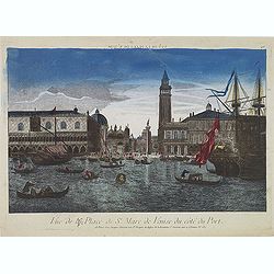
Vue de la Place de St Marc de Venise du côté du port.
Optical print showing the Doge's Palace (Palazzo Ducale), San Marco Square, and Saint Mark's Basilica (Basilica di San Marco in Venice, as seen from the waterside. The im...
Date: Paris, ca. 1750
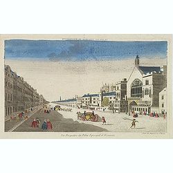
Vue perspective du palais episcopal de Westminster.
So-called optical print illustrating a perspective view of the old Palace of Westminster where the Lords and Commons met and the square facing it.. Published by Jacques C...
- $150 / ≈ €130
Date: Paris, ca. 1750
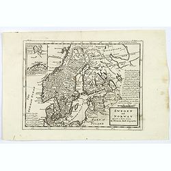
Sweden and Norway.
Herman Moll's mid eighteenth century map of Sweden and Norway, extending down to Denmark, across to Finland, and south to the Baltic states of Estonia, Livonia etc. With ...
- $125 / ≈ €108
Date: London, ca 1750
Electoratus saxonici praefecturae annaburgensis pretzschens torgaviensis schweinicensis. . .
Highly detailed map showing the regions of Annaburg, Pretzsch, Schweinitz in Sachsen-Anhalt, Torgau in Sachen and Mühlberg an der Elbe in Brandenburg. In the center of t...
Date: Augsburg, 1750
Principatus Halberstadiensis, abbat : Quedlinburgens cum Comitatu Wernigerodano, ad hodiernum verum statum ex acta prodiit ex officina geogr. . .
Detailed map showing principality Halberstadt, Abtei Quedlinburg and the county Wernigerode. Including the towns of Osterwieck, Stollberg, Aschersleben and Oschersleben.
Date: Augsburg, 1750
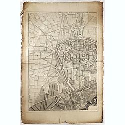
![La ville et citadelle d'Anvers. [Antwerp]](/uploads/cache/39843-250x250.jpg)
La ville et citadelle d'Anvers. [Antwerp]
A town-plan of the fortified enclosure of Antwerp with its citadel, showing the extensions made between 1201 and 1701, when the fortifications were enlarged by Philippe V...
- $225 / ≈ €195
Date: Paris, ca. 1750
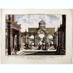
Vue du Pallais du l'Empereur de Perse avec la Mosquée, ou Eglise a Ispahan.
An optical print of the court of the Persian Emperor. Engraved by F.X. Habermann (1721-1796). The Academie Imperiale was a well-known publisher of optical prints, establi...
- $300 / ≈ €260
Date: Augsburg, 1750
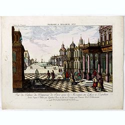
Vuë de la Cour de l'Empereur de Perse avec le diverses Habillements des Dames du premier Rang designe d'apres Nature par Quilielm Baur et fait en Estampe par François Xav. Habermann.
An optical print of the court of the Persian Emperor. Engraved by F.X. Habermann (1721-1796). The Academie Imperiale was a well-known publisher of optical prints, establi...
Date: Augsburg, 1750
![[OSTENDE] A new and exact Plan of the city and port of Ostend.](/uploads/cache/39849-250x250.jpg)
[OSTENDE] A new and exact Plan of the city and port of Ostend.
Nice plan of the city of Ostend and Fort Philippe, engraved by R. Benning. In upper left corner "A map of part of Flanders shewing the country and sands about Ostend...
- $300 / ≈ €260
Date: Paris, ca. 1750

Antoine François Prevost . . .
Portrait of Antoine François Prevost (1697 – 1763), engraved by Ficquet after a design of F.Schmidt.Prevost was born at Hesdin, Artois, and first appears with the full...
- $90 / ≈ €78
Date: Paris, ca. 1750
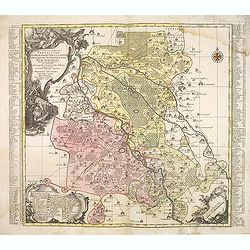
Charte der Kriegs Operationen am Donn u: Dnieper Ihro Russisch Kayserl Majestaet Glorieusen Armeen A: 1736.
Very rare separately published map of the southern part of Ukraine, with an explanatory key A-N in the lower right. The map is surrounded by letterpress German text givin...
Date: Augsburg, 1750
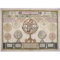
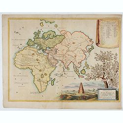
Introduction a la géographie carte des diverses positions de la sphere..
A charming and large print showing a terrestrial, celestial and an armillary globe with smaller circular diagrams illustrating the theories of Ptolemy, Copernicus, Brahe ...
- $1000 / ≈ €865
Date: Paris 1750
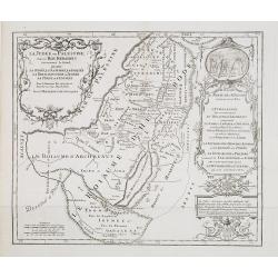
La Judée ou Palestine, sous le roi Herodes surnommé le grand, où sont la Judée, la Samarie, la Galilée, la Thrachonitide ou Iturée, la Perée et l'Idumée pour le nouveau testament et pour les livres des Machabées. . .
Scarce map of Palestine. Published by Pierre Moullart-Sanson, who was the grandson of Nicolas the elder.This is the uncommon third state. For the second state a large tit...
- $200 / ≈ €173
Date: Paris, ca.1750
L'Empire du Japon divisé en sept principales parties. . .
Large map of Japan and Korea with a distinctively French style title cartouche containing two small landscapes.The map draws heavily on the previous work of Bellin, but i...
Date: Paris, 1750

Vue de l Hotel du Lord Maire, qui comprend la Façade, et le Cot' Occidental de Londres.
Shows the famous Lord Mayor's coach driving through London. The Lord Mayor's coach is famous for its role in the Lord Mayor's Show, which is one of the longest establishe...
- $100 / ≈ €87
Date: Augsburg, 1750
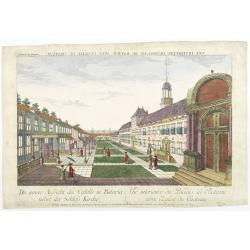
Die innere Aussicht des Castells in Batavia . . .
Showing the inside-square of the V.O.C. headquarters in Jakarta.The hand colored engraving is much perforated and the windows are cut out, a thin transparent paper is mou...
- $500 / ≈ €433
Date: Augsburg, 1750
(Title page) Le Neptune François.
Title page featuring Neptune in a sea-chariot drawn by white horses, mer-people, fleets of ships and allegorical figures of winged gods, all within an ornate border. Engr...
- $550 / ≈ €476
Date: Paris, 1750

Vue de l'Entree de la Cour.. de la rue de l'Arno a Florence
So-called optical print of Arno Street in Florence, in Tuscany region. Probst was the best-known publishers of optical prints, established in Augsburg.In the eighteenth ...
- $150 / ≈ €130
Date: Augsburg 1750
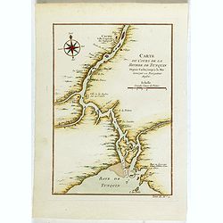
Carte du Cours de la riviere de Tunquin . . .
Map of the Tunquin Riviera. Across the top is an extensive list of 22 important sites and locations keyed to the plan with tiny letters and numbers.Jacques Nicolas Bellin...
- $200 / ≈ €173
Date: Paris, 1750
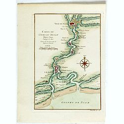
Carte du Cours du Menam . . .
Map of the Menam Riviera. Across the top is an extensive list of 22 important sites and locations keyed to the plan with tiny letters and numbers.Jacques Nicolas Bellin (...
- $200 / ≈ €173
Date: Paris, 1750
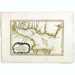
Carte de La Riviere de la Plata . . .
Map of La Plata Riviera. Across the top is an extensive list of 22 important sites and locations keyed to the plan with tiny letters and numbers.Jacques Nicolas Bellin (1...
- $350 / ≈ €303
Date: Paris, 1750
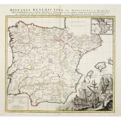
Hispania Benedictina, seu Monasteria et alia pia loca Ord. S. Benedicti ..
Map of the Iberian Peninsula and an inset map of South America with all the monasteries and holy places of the Benedictine order, compiled by the Benedictine friar Rupert...
Date: Nuremberg 1750
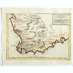
Le Pays des Hottentots . . .
Map of Good Hope Cape. Across the top is an extensive list of 22 important sites and locations keyed to the plan with tiny letters and numbers.Jacques Nicolas Bellin (170...
- $200 / ≈ €173
Date: Paris, 1750
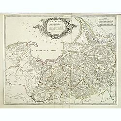
La Prusse divisée en Prusse royale, et Prusse Ducale. . .
Finely and crisply engraved map of Prussia including The Bay of Danzig. Ornamental title cartouche in the upper part of the map from his "Atlas Universel".Gille...
- $300 / ≈ €260
Date: Paris, 1750

Manuscript map of the Bay of Nagasaki.
An extremely rare manuscript chart in brown ink and wash color on a printed sheet of paper with a system of rhumblines and latitude scales. This chart shows the Bay of Na...
Date: Amsterdam, 1750
Madrid Villa Capital Del Reyno D'Espana.. / Madrid ville capitale du Royaume d'Espagne . . .
A very decorative and scarce town view of Madrid, including a numbered key ( 1-17 ) in Spanish and French in the lower part. Published by Jacques Chéreau, (1688 - 1776)....
- $3300 / ≈ €2856
Date: Paris, ca.1750
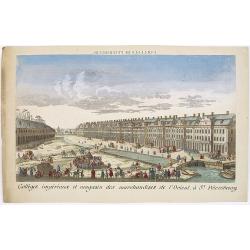
Colléges impériaux et magasin des marchandises de l'Orient, à St. Pétersbourg.
Showing a busy scene at the international trading grounds of 18th century Saint Petersburg, showing the warehouses of the different international trading companies. J. Ch...
- $200 / ≈ €173
Date: Paris, ca. 1750
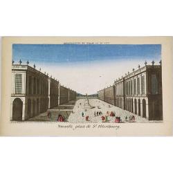
Nouvelle place de St. Pétersbourg.
Showing a square at 18th century Saint Petersburg. J. Chereau was a publisher of optical prints, established in Paris, rue St.Jacques.In the eighteenth and nineteenth ce...
- $200 / ≈ €173
Date: Paris, ca. 1750

Arc de Triomphe ou se passe la proscription d'Octave et d'Antoine.
J. Chereau was a publisher of optical prints, established in Paris, rue St.Jacques.In the eighteenth and nineteenth centuries, there were many popular specialty establish...
- $200 / ≈ €173
Date: Paris, ca. 1750
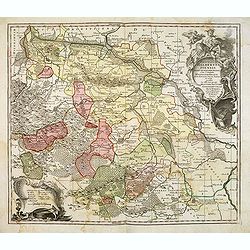
Partie Orientale de l'Empire de Russie en Asie.. et les Confins de la Tatarie Chinoise. . .
Large map with mostly topographical detail of mountains, deserts, rivers and forests. Covers the region from Tomsk eastward and includes Sakhal from his "Atlas Unive...
Date: Paris, 1750
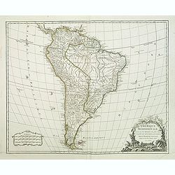
Amerique méridionale. . .
Detailled map of South America from his "Atlas Universel".Gilles Robert de Vaugondy (1688–1766), also known as Le Sieur or Monsieur Robert, and his son, Didie...
- $150 / ≈ €130
Date: Paris, 1750
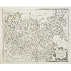
Partie Orientale de l'Empire de Russie en Asie.. et les Confins de la Tatarie Chinoise. . .
Large map with mostly topographical detail of mountains, deserts, rivers and forests. Covers the region from Tomsk eastward and includes Sakhal from his "Atlas Unive...
- $120 / ≈ €104
Date: Paris, 1750
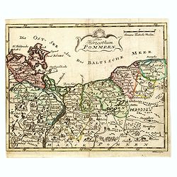
Das Hertzogthum Pommern.
Very rare map of Pomerania engraved by Johann David Schleuen (1711-1771) who was an publisher and engraver active in Berlin. He is known for his "General-Carte des g...
- $750 / ≈ €649
Date: Berlin, ca. 1750
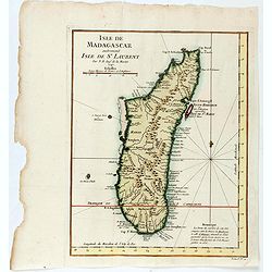
Isle de Magagascar . . .
Map of the island of Madagascar. Prepared by Jacques Nicolaas Bellin (1703-1772) who was one of the most important and proficient French cartographers of the mid-eighteen...
- $75 / ≈ €65
Date: Paris, 1750
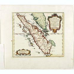
Carte de L'Isle de Sumatra Dressee sur les Journaux des Navigateurs . . .
Detailed map of Sumatra and Malacca, centered on Singapore and including the southern portion of the Malaysian peninsula. With "Detroit de Sincapour" and severa...
Date: Paris, ca. 1750
![[Lot of 13 prints of the Chinese court] Habillement de l' Empereur dela Chine & des Dames de son Palais aves quel...](/uploads/cache/IMG_0845-250x250.jpg)
[Lot of 13 prints of the Chinese court] Habillement de l' Empereur dela Chine & des Dames de son Palais aves quel...
Prints of the Chinese court.[Lot of 13 prints]- Salle Imperiale De L'Audience, tiree de Nieuhof (1760)- Pagodes ou Statues; Miniso ou la Volupté (1749- Pagodes ou sta...
- $400 / ≈ €346
Date: Amsterdam, c. 1750

Carte particuliere des costes de Poittou, Aunis et de la Rochelle.
Finely designed and rare map of Isle Ré and the French coast with La Rochelle.
- $1250 / ≈ €1082
Date: Amsterdam, c. 1750
Turin. Ville Capitale du Piemont et Residence du Duc de Savoye Roy de Sardigne.
A very decorative and extremely rare town-view of Turin, including a numbered key ( 1- 28 ) in lower part. Published by Jacques Chéreau, (1688 - 1776). Engraved by Pierr...
- $2500 / ≈ €2164
Date: Paris, ca.1750