Browse Listings
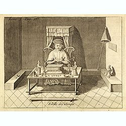
Idolle des Chinois.
Print of a Chinese divinity. Tome 3 Page 377 in upper left corner. From the French reissue of the account of early Dutch voyages first published in 1608 by Commelin. The ...
- $75 / ≈ €65
Date: Amsterdam, J.F. Bernard, 1725
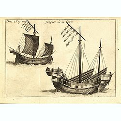
Jonques de la Chine.
A depiction of two Chinese junks. Tome 3 Page 377. From the French reissue of the account of early Dutch voyages first published in 1608 by Commelin. The French translati...
- $75 / ≈ €65
Date: Amsterdam, J.F. Bernard, 1725
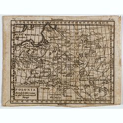
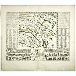
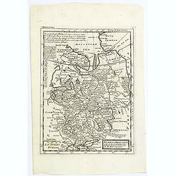
Polonia secondo le obzervazioni dell'accademiadi Parigi.
Uncommon Italian map of present day Poland and Lithuania prepared by Claude Buffier was a Jesuit theologian and geographer working in Paris, who wrote the Geographie Univ...
- $150 / ≈ €130
Date: Naples, Rome, ca. 1725
Ducatus Silesiae Iauranus. Aut : Frid : Kühnovio. . .
Rare Pieter Schenk edition of Friedrich Kubn's (Kühnovio) map of Jawor in southwest Poland based on Johann Gottfried Bartsch, map first published in Świdnica (then Schw...
Date: Amsterdam, 1700-1725
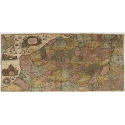
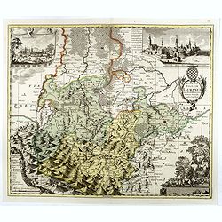
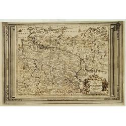
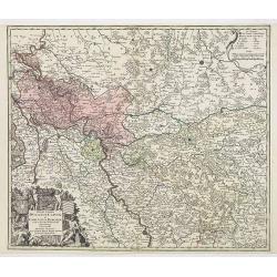
Les Provinces des Pais Bas Autrichiens contenants en XXIV Feuilles les comtées d'Artois, de Flandres, de Hainaut, de Namur et des Duchées de Luxembourg…
Rare wall map of the Catholic of Austrian Low Countries, roughly the southern part of present-day The Netherlands, Belgium and Luxembourg. Map has some large cartouches, ...
Date: Augsburg, 1725
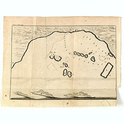
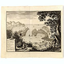
(Bird's eye view of the Bay of Bantam)
Early view of the Bay of Bantam with the islands of Pulo dua and Batto.Bantam was always a product of the ferocious commercial rivalry between the Dutch and English and P...
- $75 / ≈ €65
Date: Amsterdam, F. Bernard, 1725
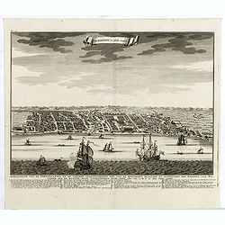
Samboepo in platte Grond.
Decorative panoramic view of the town of Samboupo on the island of Celebes (Sulawesi) in today's Indonesia. Dutch (V.O.C.) sailing ships and various local craft fill the ...
- $150 / ≈ €130
Date: Amsterdam, 1726
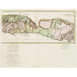
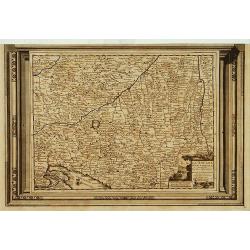
Cilicia Asiae Minoris pars orientalis. . .
Uncommon map of Cilicia, an ancient region and former kingdom of SE Asia Minor, between the Taurus Mountains and the Mediterranean: corresponds to the region around prese...
Date: Paris/ Bordeaux, 1726
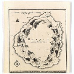
Makjan Geheel Bergagtig.
The island of Makian in Indonesia (formerly the Dutch East Indies) is represented on this map as a mountainous Möbius strip around a giant donut hole. François Valentij...
- $150 / ≈ €130
Date: Amsterdam, 1726
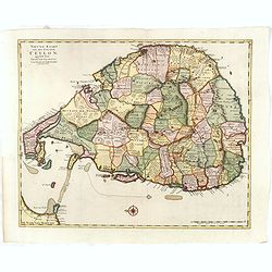
Nieuwe kaart van het Eyland Ceylon. . .
Fine map depicting the Island of Ceylon/Sri Lanka, oriented with north to the left.. Good interior detail is given with settlements, roads, etc. An attractive early map, ...
- $850 / ≈ €736
Date: Amsterdam, 1726
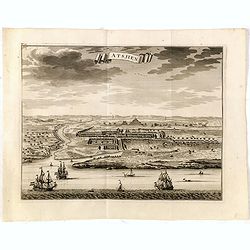
Astjien.
Nice bird's eye-view of the Town of Atjien on the northernmost point of Sumatra by François Valentijn (1666-1727), a missionary, who worked at Amboina from 1684 to 1694 ...
- $225 / ≈ €195
Date: Amsterdam, 1726
Haven van Aquapulco in ' Coninkryk van Nova Spagnien in de Zuyd Zee.
A finely engraved plan of the harbor, fort and village of Acapulco drawn from a hilltop vantage point looking out to sea. Several galleons are pictured approaching or anc...
- $500 / ≈ €433
Date: Amsterdam, 1726
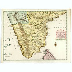
Nieuwe Kaart van Choromandel ende Malabar. . .
Fine map depicting the southern part of India and the northern tip of Ceylon. Much detail is given along the coastlines, settlements and principal coastal features are id...
- $550 / ≈ €476
Date: Amsterdam, 1726
Samboepo in platte Grond.
Decorative panoramic view of the town of Samboupo on the island of Celebes (Sulawesi) in today's Indonesia. Dutch (V.O.C.) sailing ships and various local craft fill the ...
- $150 / ≈ €130
Date: Amsterdam, 1726
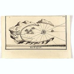
Batsjan. (Bacan)
Decorative panoramic view of Bay with the Dutch fortress Barneveld at the island of Bacan in today's Indonesia. Dutch (V.O.C.) sailing ships are illustrated.François Val...
- $45 / ≈ €39
Date: Amsterdam, 1726

Osmann der altiste sohn Achmats der Ersten.
Portrait of Osmann (1605-1622) by Franz Christoph Khevenhiller, from Annales Ferdinandei, oder warhaffte Beschreibung Käysers Ferdinandi des anderen, mildesten Gedächtn...
Date: Leipzig, Weidmann 1721-1726
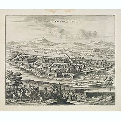
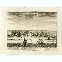
La Ville de Bagdad, dans la Turquie.
Decorative view of the town of Bagdad. This well executed engraving was published in 1729 and 1727 by Pieter van der AA, in Leiden in "Voyages tres-curieux et tres-r...
Date: Leiden, 1719-1727
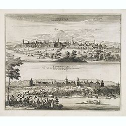
Soratof, ville de Tartarie Moscovite. / Tzornogar, Petite Ville des Moscovites, dans le Royaume d'Astracan, sur le bord du Volga.
Decorative engraving of two panoramic views in top Saratov with in the foreground the Volga River and in bottom a view of Chernyy Yar on the Volga River. This well execut...
Date: Leiden, 1719-1727
Cassimogorod ville de la Tartarie Moscovite.
Decorative view of the town of Kasimov on the Oka River, east from Moscow and south from Murom near the northern shore of the Caspian Sea. The city is seen from across th...
Date: Leiden, 1719-1727
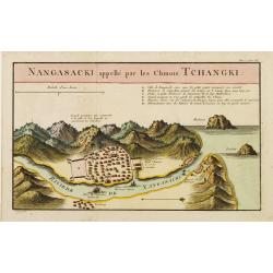
Nangasaki appellé par les Chinois Tchangki.
Attractive bird's-eye view of Nagasaki, with reference key to principal points of interest, including the Dutch V.O.C. Company House. The Dutch/Chinese enclave is central...
- $250 / ≈ €216
Date: Paris, 1727
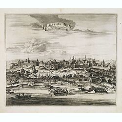
Zariza, petite ville des Moscovites, dans le royaume d'astracan, sur le bord du Wolga.
Decorative view of the town of Volgograd (Zarizyn) on the Volga River. This well executed engraving was published in 1729 and 1727 by Pieter van der AA, in Leiden in &quo...
Date: Leiden, 1719-1727
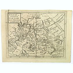
Great or Asiatick Tartary, Agreeable to Modern History.
A map from the Frozen Ocean in the north to Usbec Tartary in the south, from Moscow in the west to China Tartary and Peking in the east. Rivers and mountains feature prom...
- $125 / ≈ €108
Date: London, ca. 1727
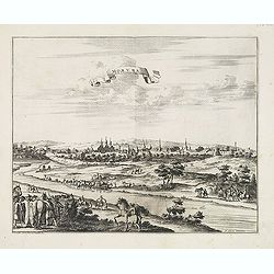
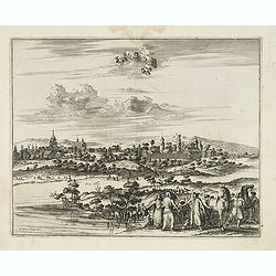
Moruma ville de la Tartarie Moscovite.
Decorative view of the town of Moruma, Russian city near the northern shore of the Caspian sea as seen from across the river Oka. This well executed engraving was publish...
Date: Leiden, 1719-1727

Great or Asiatick Tartary, Agreable to Modern History.
Map of Tartary to Peking. The eastern coastline of Asia is almost flat, with no attempt to mark Kamchatka.
- $275 / ≈ €238
Date: London, 1727
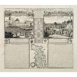
Succession Des Empereurs Du Japon Avec Une Description Du Meurtre De L'Empereur Cubo Et La Reception Des Ambassadeurs Hollandais En Ce Pays . . .
Composite sheet, with a small map of Japan and two detailed views: one depicting the murder of the Emperor Cubo, the other, the reception of the Dutch ambassadors, each w...
- $300 / ≈ €260
Date: Amsterdam, 1728
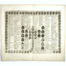
Carte genealogique des Rois de France avec l'Etat des Principaux Officiers de la Maison du Roy.
A genealogical tree of the French Kings with descriptive French text, from Chatelain's monumental 7 volume "Atlas Historique". Henri Abraham Chatelain (1684 –...
- $35 / ≈ €30
Date: Amsterdam, 1728
![[Title page] Atlas Historique ou nouvelle introduction à l'Histoire, à la Chronologie & à la Géographie Ancienne & Moderne . . . (Tome I)](/uploads/cache/39002-250x250.jpg)
[Title page] Atlas Historique ou nouvelle introduction à l'Histoire, à la Chronologie & à la Géographie Ancienne & Moderne . . . (Tome I)
Title page from Chatelain's monumental 7 volume Atlas Historique, Tome I. Henri Abraham Chatelain (1684 – 1743) was a Huguenot pastor of Parisian origins. He lived cons...
- $30 / ≈ €26
Date: Amsterdam, 1728
A Chart of the Sound -- A Map of the rivers Elbe and Weser -- The River Dvina and the harbour of Archangel.
Scarce sea chart by John Harris (1667?-1719) and James Knapton (d. 1738). Chart 20 from "Atlas maritimus & commercialis", shows Lapland and part of the Russ...
- $400 / ≈ €346
Date: London, J. Knapton, 1728
Turquie en Asie, suivant les nouvelles observations..
Uncommon edition of this map of Turkey, Holy Land, Armenia, including Cyprus. With decorative title cartouche lower left corner.This example is unusual in having the addi...
Date: Leiden, 1728
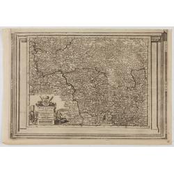
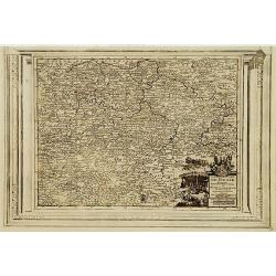
Le Duché de Lunebourg, suivant les nouvelles observations?
Uncommon edition of this map of a province of Germany. With decorative title cartouche upper right corner.This example is unusual in having the additional separately engr...
- $80 / ≈ €69
Date: Amsterdam, 1728
![[Two dogs]](/uploads/cache/47484-250x250.jpg)
[Two dogs]
Print representing two dogs. Number 12 in the lower right corner. From a series of prints showing various dogs.Disciple of Georg Philipp Rugendas I in Augsburg, Johann El...
Date: Augsbourg 1728
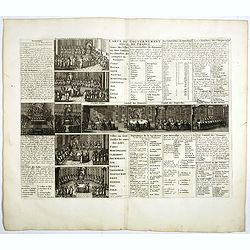
Carte du Gouvernement Civil de France.
This impressive engraving is a wonderful example of Chatelain’s elegant plates. It provides a detailed description of the infrastructure of the French government. Ornam...
- $75 / ≈ €65
Date: Amsterdam, 1728
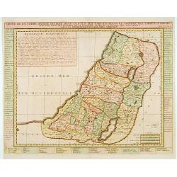
Carte de la Terre Sainte Divisée dans toutes ses. . .
A finely engraved map depicting the division of the Holy Land into twelve tribes.
- $400 / ≈ €346
Date: Amsterdam, 1728
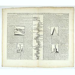
Description du Nil, de ses sources, de son cours depuis les cataractes jusques le Caire . . .
Detailed map of the course of the Nile, from the cataracts of the Nile at the south (top of the image) to Caïro and Giza. At the right, one of the Pyramids is shown (140...
Date: Amsterdam, 1728
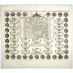
Carte Pour L'Intelligence De L'Histoire De Lorraine . . .
Map of Lorraine, surrounded by 34 portraits of the rulers of Lorraine and information concerning the present government structure of the Duchy. Surmounted by an elaborate...
Date: Amsterdam, 1728
Division generale de l'Amerique dans ses principales parties pour l'intelligence de la carte de ce païs.
This folio sheet gives a breakdown of America into the northern and southern regions. These are further subdivided into the various countries and provinces.Henri Abraham ...
Date: Amsterdam, 1728
Cercle de la Basse Saxe, suivant les nouvelles observations..
Uncommon edition of this map of a province of Germany, including Hamburg, Bremen, etc. With decorative title cartouche lower right corner.This example is unusual in havin...
- $90 / ≈ €78
Date: Amsterdam 1728
La Souabe meridionale, suivant les nouvelles observations..
Uncommon edition of this map of Southern Germany. With decorative title cartouche lower right corner.This example is unusual in having the additional separately engraved ...
- $90 / ≈ €78
Date: Amsterdam 1728
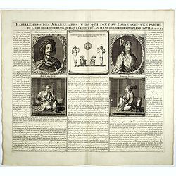
Habillemens Des Arabes & Des Juifs qui sont au Caire avec une partie de leurs divertissements & quelques restes de L'Ancien Idolatrie des peuples D'Egipte.
Decorative set of images the costumes of the Arab and Jewish inhabitants of Cairo, with French text, from Chatelain's monumental 7 volume Atlas Historique. Henri Abraham ...
Date: Amsterdam, 1728
![[No title] Mongol.](/uploads/cache/39729-250x250.jpg)
[No title] Mongol.
Interesting sheet with four detailed engravings illustrating Mongol's life scenes. In upper right margin: 'Tom. V. No 43. Pag: 116.Henri Abraham Chatelain (1684 – 1743)...
Date: Amsterdam, 1728
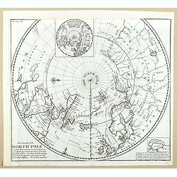
This Draught of the North Pole is to show all the Countries near and adjacent to it . . .
The polar map shows the latest discoveries and routes of numerous explorers during their attempts to find a Northwest and Northeast Passage, including James, Hudson, and ...
- $300 / ≈ €260
Date: London, ca. 1728
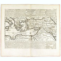
Carte historique et géographique pour servir à l'Histoire Sainte et à la Vocation de Saint Paul, avec quelques remarques curieuses pour servir à l'Histoire des Antiquités judaïques.
Interesting sheet with a map of the travels of Saint Paul, including eastern part of Europe, Asian continent and part of north Africa, with descriptive French text, from ...
Date: Amsterdam, 1728
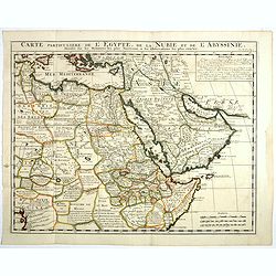
Carte Particuliere De L'Egypte, De La Nubie et de L'Abyssinie, Dressee sur les Memoires les plus Nouveaux & les Observation les plus exactes.
Including the Arabian Peninsular, Egypt, north eastern part of Africa, Cyprus and part of the Mediterranean.Based on the work of Guillaume Delisle. It is a very detailed ...
- $400 / ≈ €346
Date: Amsterdam, 1728
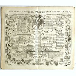
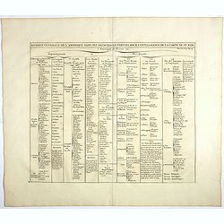
Généalogie des Cazrs de Moscovie ou empereurs de la grande Russie . . .
Genealogical tree, showing the lineage of the Russian Czar's, dating back to 840 according to Hubner. Published by Henri Abraham Chatelain (1684 – 1743) a Huguenot past...
- $250 / ≈ €216
Date: Amsterdam, 1728
![[No title] Hindou](/uploads/cache/39730-250x250.jpg)
[No title] Hindou
Interesting sheet with four detailed engravings illustrating Hindou's life scenes. In upper right margin: 'Tom. V. No 42. Pag: 116.Henri Abraham Chatelain (1684 – 1743)...
Date: Amsterdam, 1728
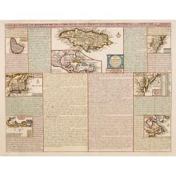
Carte qui contient..Iles & Terres..L'Amerique..Jamaique..
Eight maps on one sheet. From Chatelain's Atlas Historique et Méthodique . Including maps of Bermuda, Jamaica, New England with Long Island, Carolina, Chesapeake and Del...
Date: Amsterdam, 1728
Nova et Accurata Ducatus Cliviae et Comitatus Marchiae.
With an elaborate -uncolored- title cartouche.
Date: Augsburg, 1728
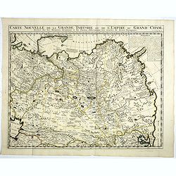
Carte Nouvelle de la Grande Tartarie ou de l'Empire du du Grand Cham. . .
Very detailed map of Northern China, Korea, Russia in the north the Murmansk Sea. Including the western coast of Nova Zembla. Zacharie Chatelain (d.1723) was the father o...
- $250 / ≈ €216
Date: Amsterdam, 1728
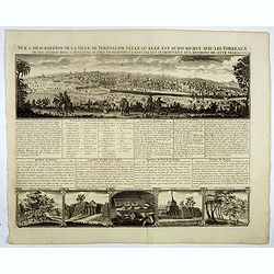
Vue & discription de la Ville de Jerusalem..avec Tombeaux..
This copper-engraving shows a panoramic view of Jerusalem, two insets of mount "Liban" and three insets of the tombs De Zacharie, Des Rois, and D'Absalom.Zachar...
- $400 / ≈ €346
Date: Amsterdam, 1728
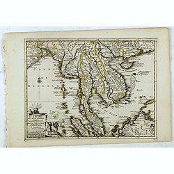
L'Inde de la le Gange, suivant les nouvelles observations...
Decorative map of Malaysia, Thailand, Indo-China, and the Northern parts of the islands of Sumatra and Borneo. Singapore marked as Sincapour.Originally published by Piete...
Date: Amsterdam, 1728
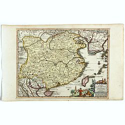
La Chine suivant les nouvelles observations...
Uncommon edition of this map of China. From Le Nouveau Theatre du Monde, ou la Geographie Royale.Curious shape of South Korea.
- $1100 / ≈ €952
Date: Amsterdam, 1728
L'Archeveché de Mayence, suivant les nouvelles observations..
With decorative title cartouche lower left corner. Including river Rhine. This example is unusual in having the additional separately engraved decorative framework border...
- $100 / ≈ €87
Date: Amsterdam, 1728
Carte Historique et Geographique pour Introduire a l' Intelligence de l'Histoire de Savoye . . .
Folio sheet with an attractive map of the border region of France, Switzerland and Italy. An inset map of the fortification of Torino and the Palace of Venerie. Cartouche...
Date: Amsterdam, 1728

Nieuwe Wassende Graade Zee Kaart over de Spaanse Zee Vant Kanaal tot 't Eyland Cuba in Westindia. . .
¤ Engraved by I.van Anse. A very representative example of a Dutch chart of the Atlantic, showing the north-east coast of America, the coasts of Africa and Europe and So...
Date: Amsterdam, 1728
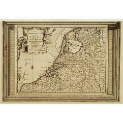
Les Provinces Unies des Pays Bas, suivant les nouvelles observations. . .
With decorative title cartouche upper left corner.This example is unusual in having the additional separately engraved decorative framework border around the map, the res...
Date: Amsterdam, 1728
L'Italie dans son Premier Etablissement sous la Republique Romaine. . .
Map of Italy when first established under the Roman Republic after the division by Ayuguste Caesar, its various Papal governments: ancient Rome and its surround dings, a ...
Date: Amsterdam, 1728
Landgraviat de Hesse, suivant les nouvelles observations..
With decorative title cartouche lower right corner.This example is unusual in having the additional separately engraved decorative framework border around the map, the re...
- $90 / ≈ €78
Date: Amsterdam 1728
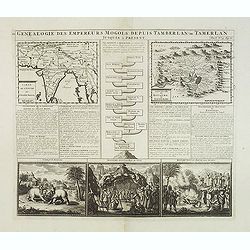
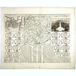
Genealogie des anciens empereurs mogols,. . .
Text sheet with two inset maps of "Carte de l'empire du grand Mogol (122x158mm.) and inset map of Kahsmire "carte nouvelle du royaume de Kachemire" (120x15...
- $150 / ≈ €130
Date: Amsterdam, 1728
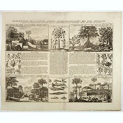
Description des plantes, arbres, animaux & poissons des Antilles . . .
Interesting sheet with eight detailed views illustrating fauna and flora on the Antillean islands, and how the natives are making sugar, with descriptive French text, fro...
- $150 / ≈ €130
Date: Amsterdam, 1728
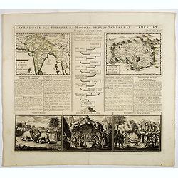
Genealogie des empereurs Mogols . . .
Text sheet with two inset maps of "Carte de l'empire du grand Mogol (122x158mm.) and inset map of Kahsmire "carte nouvelle du royaume de Kachemire" (120x15...
- $150 / ≈ €130
Date: Amsterdam, 1728
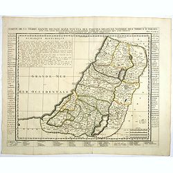
Carte de la Terre Sainte Divisée dans toutes ses parties. . .
A finely engraved map depicting the division of the Holy Land into twelve tribes.Zacharie Chatelain (d.1723) was the father of Henri Abraham (1684-1743) and Zacharie Juni...
- $350 / ≈ €303
Date: Amsterdam, 1728
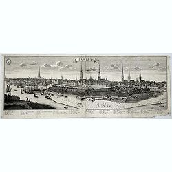
Hamburg.
A spectacular panoramic view of Hamburg, with legends numbered 1-19 and A-Z in German. With the title in a banderol.After a design by Friedrich Bernhard Werner (1690-1776...
- $2000 / ≈ €1731
Date: Augsburg, 1729
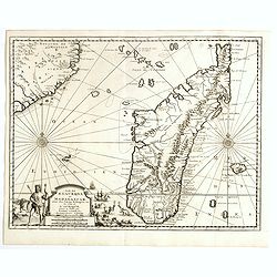
Ile de S. Laurens, ou Madagascar, située dans L'Ocean Ethiopien, sur les Côtes de L'Afrique.
Detailed map of Madagascar and Réunion. Published by Pieter van der Aa in "Galérie agréable du monde", completed in 1729. The Galerie was a sixty-six volume ...
Date: Leiden, 1729
Orbis terrarum typus de integro in plurimis emendatus auctus et icunculis illustratus.
Outstanding and rare example of a bible world map based on the Visscher bible map from 1657 (Shirley 401/414). This map is larger in size and has an extra engraved frame ...
Date: Minden, 1729
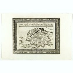
Projet de la forteresse de Nice.
Nice city plan of Nice at the Mediterranean sea. From the " Les forces de l'Europe, ou description des principales villes, avec leurs fortifications".
Date: Leiden, 1729
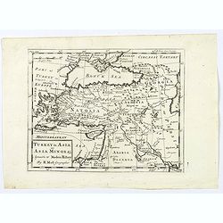
Turkey in Asia: or Asia Minor &c.
Herman Moll's map of the Turkish Empire in Asia, published in London during the first half of the eighteenth century. It shows the eastern Mediterranean, including Crete ...
- $150 / ≈ €130
Date: London, ca 1729

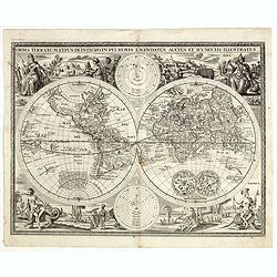
Carte Generale de la Terre ou Mappe Monde avec les quatres principaux systemes..
A rare double hemisphere world map, including the tracks of Tasman (1642) and Magellan (1520) and St. Antoine (1710) and surrounded with circular diagrams illustrating th...
Date: Paris, ca. 1729
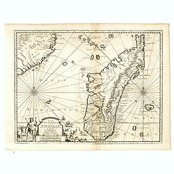
Ile de S. Laurens, ou Madagascar, située dans L'Ocean Ethiopien, sur les Côtes de L'Afrique.
Detailed map of Madagascar and Réunion. Published by Pieter van der Aa in "Galérie agréable du monde", completed in 1729. The Galerie was a sixty-six volume ...
Date: Leiden, 1729
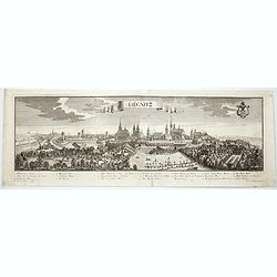
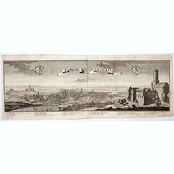
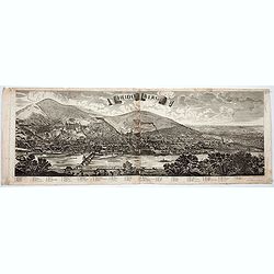
Lirgnitz. (Legnica)
A spectacular panoramic view of Legnica in southwestern Poland, in the central part of Lower Silesia, with legends numbered from 1-20 in German. With the title in a bande...
- $2500 / ≈ €2164
Date: Augsburg, 1729
Russia or Moscovy with its Acquisitions &c.
Herman Moll's map of western Russia, or Muscovy, published in London during the first half of the eighteenth century. It shows the newly acquires lands taken from Sweden ...
- $200 / ≈ €173
Date: London, 1729
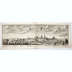
Neis in Schlesien. (Nysa)
A spectacular panoramic view of Nysa in southwestern Poland, with legends numbered from 1-23 in German. With the title in a banderol.After a design by Friedrich Bernhard ...
- $2500 / ≈ €2164
Date: Augsburg, 1729
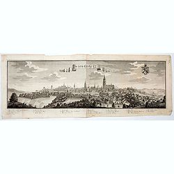
Schweidnitz. (Swidnica)
A spectacular panoramic view of Swidnica is a city in south-western Poland, with legends numbered from 1-19 in German. With the title in a banderol.After a design by Frie...
- $2500 / ≈ €2164
Date: Augsburg, 1729
Bamberg in Francken.
A spectacular panoramic view of Bamberg, with legends numbered from 1-24 in German. With the title in a banderol.After a design by Friedrich Bernhard Werner (1690-1776) w...
- $1500 / ≈ €1298
Date: Augsburg, 1729
Novum Amsterodamum. . .
Three engravings on one page are set in a decorative, separately engraved border. - In the upper left is a good example of one of the earliest available views of New York...
Date: Leiden, 1729
Lübeck.
A spectacular panoramic view of Lübeck, with legends numbered 1-28 in German. With the title in a banderol.After a design by Friedrich Bernhard Werner (1690-1776) who wa...
- $1500 / ≈ €1298
Date: Augsburg, 1729
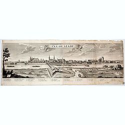
Ingolstadt.
A spectacular panoramic view of Ingolstadt in Bavaria, with legends numbered from A-P and 1-6 in German. With the title in a banderol.After a design by Friedrich Bernhard...
- $1500 / ≈ €1298
Date: Augsburg, 1729
Heidelberg.
A spectacular panoramic view of Heidelberg, with legends numbered from 1-72 in German. With the title in a banderol.After a design by Friedrich Bernhard Werner (1690-1776...
- $1500 / ≈ €1298
Date: Augsburg, 1729
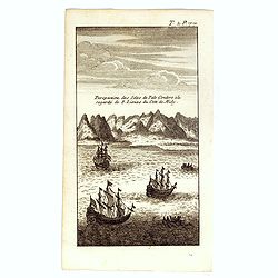
Perspective des Isles de Palo Condoro à le regarde de 8 lieües di coté de Midy.
An attractive view of the Isle de Condor (Côn Son Island), located off the southern tip of Vietnam and a victualing point by European traders. In 1702, the English East ...
- $150 / ≈ €130
Date: Paris / Amsterdam, ca 1730
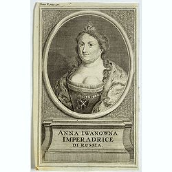
Anna Iwanowna Imperadrice di Russia.
Portrait of Anna Iwanowna (1693 – 1740), was regent of the duchy of Courland from 1711 until 1730 and then ruled as Empress of Russia from 1730 to 1740.
- $75 / ≈ €65
Date: France, ca. 1730
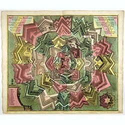
Architecturae Militaris Synopsis, ... / Vollstaendiger Entwurff der Ingenieur Kunst . . .
Decorative large sheet with elements of different types of fortress architecture and the name of the engineers or military architects: Blondel, Bourdin, Doegen, Borgsdorf...
- $650 / ≈ €563
Date: Augsburg, circa 1730