Browse Listings
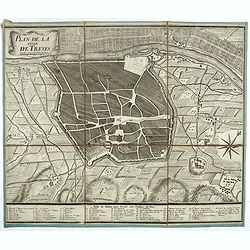
Plan de la ville de Treves.
Very rare town-plan of Trier by Didier Bugnon (1676-1736), geographer of the Duke of Lorraine. With numbered key (1-57) of the main buildings and buildings of the city. T...
Date: Paris?, 1720
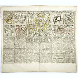
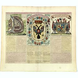
Carte des Grisons et des Communautez qui Composent leurs Ligues, les Etats de St. Gal, Neuchastel, Geneve et Quelques Autres Etats Alliez des Suisse.
This finely engraved sheet provides the history of various cities and regions allied with Switzerland at the beginning of the eighteenth century. The top section of the s...
- $150 / ≈ €130
Date: Amsterdam, 1720
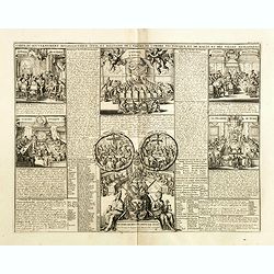
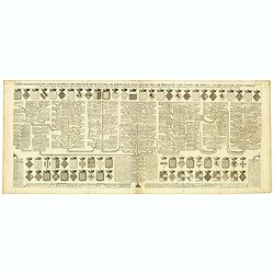
Carte du gouvernement ecclesiastique civil et militaire de l'Empire de l'ordre teutonique et de Malte et des villes anseatiques.
Interesting sheet with a detailed series of views showing the various councils of the Hanseatic League, including the councils of war, finance, state and the college of t...
- $75 / ≈ €65
Date: Amsterdam, 1720
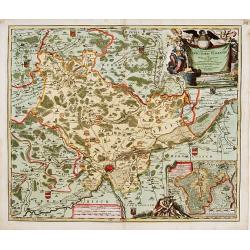
Saxoniae Superioris
Impressive title cartouche with miniature panoramic view of Leipzig, coat of arms, putti and Mercury.Johann Baptist Homann born in Kammlach (1663). He was engraver, map-s...
- $150 / ≈ €130
Date: Augsburg, 1720
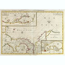
Carte Particuliere de Isthmus ou Darien qui Comprend le Golfe de Panama &c. Cartagena, et les Isles aux Environs.
Finely executed map of a portion of Central America, extending from the East Coast of Nicaragua and Costa Rica in the northwest to Cartagena and Santa Martha in modern Co...
- $1250 / ≈ €1082
Date: Amsterdam, 1720
Carta Hydrographica oder Algemeine Welt. . .
World map in Mercator projection. Showing California as an island. In the upper left and right-hand corner two ships. The map is showing the important trade routes.
Date: Augsburg, 1720
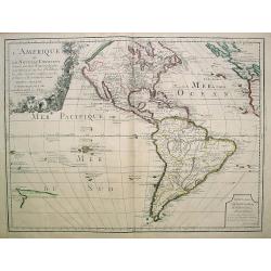
L'Amerique ou le Nouvelle Continent.. Dedieé et presenteé a monseigneur Law.
State one. The map has been prepared by Jean Baptiste Nolin (the elder) has a dedication to Monseigneur LAW controlleur general des finances .Rare general map of the Amer...
- $2200 / ≈ €1904
Date: Paris, 1720
Carte genealogique de la famille Royale de Brunswick . .
A very detailed composite sheet with a genealogical table of the German royal families of Brunswick, Luneburg and Hanover, with descriptive French textZacharie Chatelain ...
- $50 / ≈ €43
Date: Amsterdam, ca. 1720
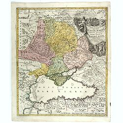
Tabula Geographica qua pars Russiae Magnae. . .
Homann's map is based upon Beauplan's general map of Ukraine but depicts the political changes of the preceding years. With decorative cartouches. Giving good detail alon...
Date: Nuremberg, 1720
![[Title page] Gli Argonauti.](/uploads/cache/23338-250x250.jpg)
[Title page] Gli Argonauti.
Decorative title page illustrating allegorical and mythological figures. Engraved by Alessandro Dalla Via after a drawing by Lodovico Lanberti.At the top some cherubs car...
Date: Venice, ca. 1720
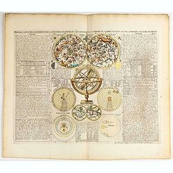
Premiere carte pour l'Introduction a l'histoire du monde, ou l'on remarque la Sphere, le Globe Celeste. . .
Featuring a small double hemisphere world map, showing California as an island, North and South Polar celestial hemispheres, an Armillary Sphere, below with smaller circu...
- $500 / ≈ €433
Date: Amsterdam, 1720
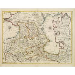
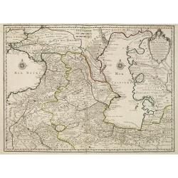
Carte des Pays voisins de la Mer Caspiene. . .
A most attractive and detailed map of the region between the Black and Caspian Seas after De L'Isle. The two Seas are decorated with compass roses. This is one of the few...
Date: Amsterdam, 1720
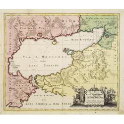
Maris Assoviensis vel de Zabache et Paludis Maeotidis. . .
A very detailed map showing the Black Sea, Azow and Rostow area.
Date: Augsburg, 1720
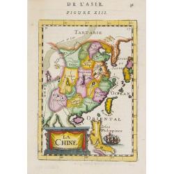
La Chine.
A charming small map of China, Taiwan, the Philippines, Korea, and Kyushu (Japan). By Allain Manesson Mallet (1630-1706), a well-traveled military engineer and geographer...
- $300 / ≈ €260
Date: Paris, 1720
Het Groote Tafereel der Dwaasheid, vertoonende de opkomst, voortgang en ondergang der Actie, Bubbel en Windnegotie, in Vrankryk, Engeland, en de Nederlanden, ...
FIRST ISSUE of this biting and vulgar satire on the Mississippi and South Sea Bubbles and an extraordinary visual record with 78 plates of the first banking crash, show...
- $7500 / ≈ €6491
Date: Amsterdam, 1720
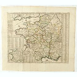
Carte Geographique du Royaume de France, avec des remarques curieuses sur l'ancienne, et la nouvelle geographie.
Map of France with a key table to the towns on both sides.Zacharie Chatelain (d.1723) was the father of Henri Abraham (1684-1743) and Zacharie Junior (1690-1754).They wor...
Date: Amsterdam, ca. 1720
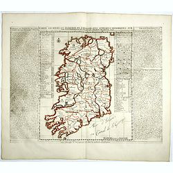
Carte ancienne et moderne de l'Irlande, avec quelques remarques sur son gouvernement . . .
Map of Ireland, based upon the ancient and modern cartographic information as of the beginning of the 18th Century. From Chatelain's monumental 7 volume "Atlas Histo...
- $200 / ≈ €173
Date: Amsterdam, 1720
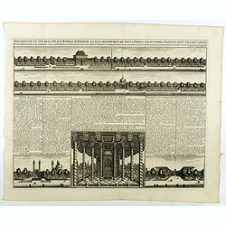
Description te vue de la Place d'Ispahan . . .
Pair of decorative views showing the Royal Palace at Isfahan (Esfahan) and the Royal Mosque of Abas the Great. From Chatelain's monumental 7 volume "Atlas Historique...
- $125 / ≈ €108
Date: Amsterdam, 1720
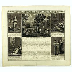
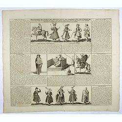
Mariage des Turcs & des Armeniens, avec la ma niere dont se font les demonstrations d'amour . . .
Showing the marriage rituals and lives of Turks and Armenians. Five engravings set round a text panel in French. From Chatelain's monumental 7 volume "Atlas Historiq...
- $150 / ≈ €130
Date: Amsterdam, 1720
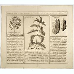
Description, figure et qualité de l'arbre, du café, avec la manière de le cultiver et d'en cueillir le fruit.
Decorative copperplate engraving showing a coffee tree, plant and fruit, with an lengthy description about its growing process.From Chatelain's monumental 7 volume "...
- $75 / ≈ €65
Date: Amsterdam, 1720
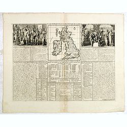
Carte Pour l'Introduction a l'Histoire d'Angleterre, ou l'on Voit son Premier Gouvernement, et l'Etat Abrege de cette Monarchie sous les Empereurs Romains, et sous les Rois Saxons.
The sheet includes a large inset map of Roman Britain including the English Channel and the western coast of France (200 x 255mm.). It also provides a wealth of informati...
- $200 / ≈ €173
Date: Amsterdam, 1720
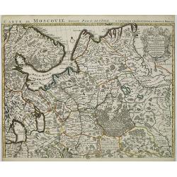
Carte de Moscovie. . .
Centred on Moscow, including Lapland. With fine uncolored title cartouche.
Date: Amsterdam, 1720
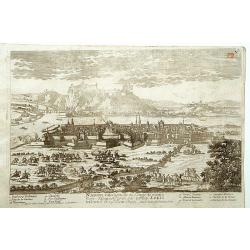
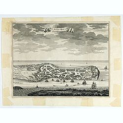
Namur.
A very RARE panoramic of the city of Namur, with a numbered legend in both lower corners.The plate is numbered in red pencil in upper right corner.Engraved by Pierre Avel...
- $150 / ≈ €130
Date: Paris, 1690-1720
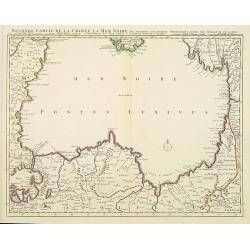
Seconde partie de la Crimee la Mer Noire. . .
The lower part of a set of two maps from the observations of Guillaume Delisle focusing on the Black Sea with wonderful detail of the surrounding regions. Includes Consta...
- $750 / ≈ €649
Date: Amsterdam, 1720
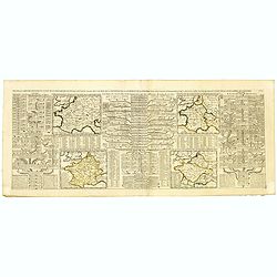
Nouvelle Carte des Differents Etats de la Monarchie Françoise Sous Iule Cesar, Sous les Rois de la Premiere, de la Seconde . . .
Four maps of France surrounded by historical and genealogical information to the history, chronology, ancient and modern genealogy of the french monarchy.Henri Abraham Ch...
- $75 / ≈ €65
Date: Amsterdam, 1720
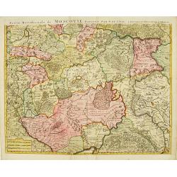
Partie Meridionale de Moscovie..
Centered on Moscow, including Azow in the bottom part of the map.The Amsterdam publishing firm of Covens and Mortier (1721 - c. 1862) was the successor to the extensive p...
- $300 / ≈ €260
Date: Amsterdam 1720

Huquang, Kiangsi, Chekiang ac Fokien.
A reissue of Janssonius' map of south east China, with wash color and uncolored cartouches.The map is based on the maps of Martin Martini, themselves based on Chinese sou...
Date: Amsterdam, 1720
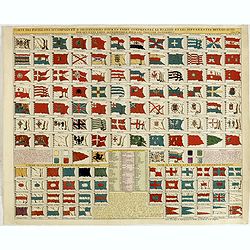
Carte des pavillons accompagnée d'observations pour en faire comprendre le blazon et les différentes devises aussy bien que d'une table alphabétique pour les trouver facilement.
A plate of 88 marine flags, including Malta, Turkey, Middelburg, Amsterdam, Portugal, Monaco, Tuscany, China, Nanking, the French Royal flag, the French admiralty flag an...
- $1200 / ≈ €1039
Date: Amsterdam, 1720
Partie Meridionale de Moscovie. . .
Scarce map centered on Moscow including Azow and part of present-day Ukraine in the bottom part of the map. The map is based on Delisle's important map of the region with...
- $750 / ≈ €649
Date: Amsterdam, 1720
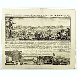
Vue et description de Bethleem et de Nazareth . . .
Decorative panoramic view of Bethlehem and Nazareth, among 3 other views of the Hall of the Annunciation and Church of Cana .From Chatelain's monumental 7 volume "At...
- $200 / ≈ €173
Date: Amsterdam, 1720
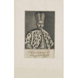
Mahomet V. Türkischer Kayser.
Portrait of Mahomet V. son of Mustapha II. succeeded in 1730, on the deposition of his uncle, Achmet III.Mahomet was more respectable for his pacific disposition, than hi...
Date: Germany, c. 1720

Carte de l'Ile de Java. . .
An inset plan of Batavia and clearly indicated rice fields, mountains, forests, towns in profile, and even elephants, suggesting the wealth of detail found on this map. M...
Date: Amsterdam, 1720

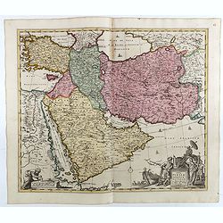
Carte Particuliere d'une Partie d'Asie ou sont Les Isles D'Andemaon, Ceylan, Les Madives . . .
An impressive large sheet chart including the Red Sea, the coasts of Somali, Yemen, east coast of the Arabian peninsula. One of the early maps to focus on this area. Nume...
- $1500 / ≈ €1298
Date: Amsterdam, 1720
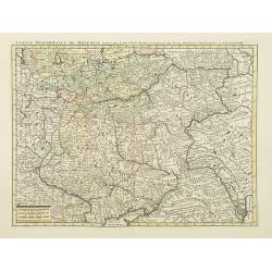
Partie Meridionale de Moscovie. . .
Centered on Moscow including Azow and part of present-day Ukraine in the bottom part of the map. The map is based on Delisle's important map of the region with revisions ...
- $200 / ≈ €173
Date: Amsterdam, 1720
Carte geographique de l'Asie mineure avec un etat des premiers rois. . .
Map of the Mediterranean. This impressive engraving is a wonderful example of Chatelain’s elegant plates from his "Atlas Historique, Ou Nouvelle Introduction A L�...
- $120 / ≈ €104
Date: Amsterdam, ca. 1720
Asia intra Maeotim Pontum et Mare Caspium. . .
Striking map the Black Sea and Caspian Sea regions, featuring the geographical features known to the ancients and decorated with a vignette and 10 medallions.From "D...
- $195 / ≈ €169
Date: Nuremberg, 1720
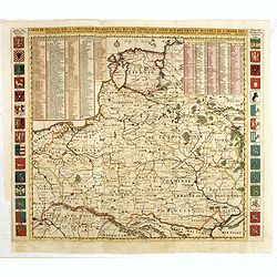
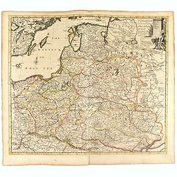
Carte De Pologne Avec La Chronologie Des Rois Et Des Ducs De Lithuanie, Ainsi Que Des Grands M. De L'Ordre Teutonique Les Evechez et Archeveches, et Les Armes Des Provinces . . .
Map of Poland with a key table to the towns, and 30 coats of arms on both sides, extending south the Black Sea. From Chatelain's monumental 7-volume "Atlas Historiqu...
- $1000 / ≈ €865
Date: Amsterdam, 1720
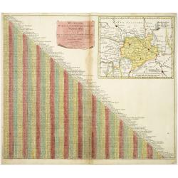
Wegweiser duch das Chiurfurstenthumb Sachen.
Showing distances in-between towns in Saxen, Germany. In upper right hand corner inset map of Saxen, showing Leipzig, Dresden, Prague.More about cartographical curiositie...
- $75 / ≈ €65
Date: Amsterdam 1720
Carte du gouvernement militaire d'Angleterre où l'on représente l'état des officiers de guerre et celui des forces de terre et de mer.
Interesting sheet with a decorative map on the British Isles, with idyllic scenes showing councils of the various military officers of the British Isles, with descriptive...
Date: Amsterdam, 1720
Carte pour servir à l'intelligence de l'histoire de la chronologie et de la géographie des empires des Assiriens, des Perses, des Egyptiens et des Chinois.
Interesting sheet with a map of the classical world showing the empires of the Assyrians, Persians, Egyptians and Chinese, with descriptive French text, from Chatelain's ...
Date: Amsterdam, 1720
Carte genealogique des comtes de Dreux, des Seigneursde Beaussart . . .
Genealogical chart of the earls of Dreux, from Chatelain's monumental 7 volume "Atlas Historique". Henri Abraham Chatelain (1684 – 1743) was a Huguenot pastor...
- $50 / ≈ €43
Date: Amsterdam, 1720
Nova et accurata Territorii Ulmensis cum dominio Wainensi..
"Showing the area of Ulm. In the lower part, an inset map of the property"zu Wein". Upper right splendid title cartouche.The map is painted in an intense a...
Date: Nurenberg 1720
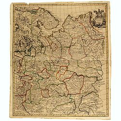
Carte du gouvernement civil ecclésiastique de moscovie, l'état des revenus et l'ordre de la justice et des officiers de la cour.
Interesting sheet with a detailed plan of Moscow, plus two large coats-of-arms, with descriptive French text, from Chatelain's monumental 7 volume Atlas Historique. In up...
- $950 / ≈ €822
Date: Amsterdam, 1720
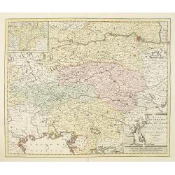
Circuli Austriaci in quo sunt. . .
Fine map of Austria, with in upper left corner a inset map of Tirol.Joachim Ottens (1663 - 1719) and his sons Renier and Joshua were prominent Dutch booksellers and map p...
- $200 / ≈ €173
Date: Amsterdam, 1720
Description des habits des Persans..
This impressive engraving is a wonderful example of Chatelain’s elegant plates.Ornamented with numerous vignettes showing the costumes of the ancient Persians.General i...
- $150 / ≈ €130
Date: Amsterdam, ca. 1720
Poland and other the Countries belonging to the Crowne According to the Newest Observation 1719
Fine map of the Polish Empire in a second edition of the map, which had been published by Morden & Browne in 1710. The remnants of the earlier address, are still slig...
- $1200 / ≈ €1039
Date: London, 1721
Moscovey in Europe from the latest Observations . . .
Fine, highly detailed map of the regions of European Russia by John Senex. Each region is depicted in original outline color, and a small decorative cartouche is in the t...
- $450 / ≈ €389
Date: London, 1721
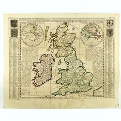
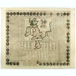
Nouvelle carte d'Angleterre, d'Ecosse et d'Irlande, avec des instructions ..
Striking large folding map of the British Isles, with large insets of the Eastern and Western Hemispheres and the coats of arms for England, Ireland, Scotland and Wales. ...
- $200 / ≈ €173
Date: Amsterdam, 1721
![[Set of 2 maps of Caspian Sea.] Carte marine de la Mer Caspiene. Levee suivant les ordres de S.M. Czariene, P](/uploads/cache/20009-250x250.jpg)
[Set of 2 maps of Caspian Sea.] Carte marine de la Mer Caspiene. Levee suivant les ordres de S.M. Czariene, P
Guillaume de l' Isle (1675-1724), Royal Geographer, was the most influential cartographer of the first quarter of the 18th century. ' Atlas de Géographie' (1700-12), pos...
- $350 / ≈ €303
Date: 1721
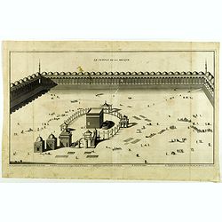
Le Temple de la Mecque.
Striking view of the Temple at Mecca, showing the Kaaba at the center of Islam's most sacred mosque, that is Al-Masjid Al-?aram, in Mecca, Hejaz, Saudi Arabia.The engravi...
- $1000 / ≈ €865
Date: The Hague, Isaac Vaillant, 1721

A Map of Turky, Arabia And Persia. Corrected from the latest Travels. . .
FIRST EDITION - Fine Turkish Empire map centered on Saudi Arabia, Cyprus and the Mediterranean Sea. Dated 1711, "Sold by John Senex at the Globe aga inst St. Dunstan...
- $1750 / ≈ €1515
Date: London, 1721
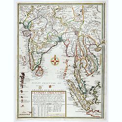
Les Indes Orientales sous le Nom de queles est compris L'Empire du Grand Mogol, Les Deux Presqu'Isles Deca et de la Le Gange, Les Maldives, et L'Isle de Ceylan . . . 1721
Rare map of the region including India, Malaysia with "Sincapur", Thailand, Sumatra, the eastern part of Java. The map is extended in the right border with Maca...
Date: Paris, 1721
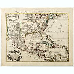
Carte du Mexique et de la Floride, des terres angloises et des isles Antilles, du cours et des environs de la rivière Mississipi. . .
A Dutch edition of De L'Isle's map. It was the first printed map to portray accurately the course and mouth of the Mississippi River. Showing the explorations of d'Ibervi...
Date: Amsterdam, 1722
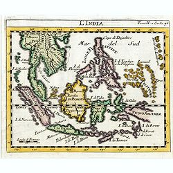
L'india.
This small Italian map of of South East Asia, with Indonesia, , Malacca is based on the cartography of Guillaume Delisle. Japan is shown attached to Ter di Yesso (Hokkai...
Date: Venice, c.1722
Carte des Pays Voisins de la Mer Caspiene dressee pour l' usage du Roy. . .
The map shows the area east of the Caspian Sea, including parts of Kazakhstan, Turkmenistan, Uzbekistan, and northern Iran. The area eastward from the Caspian is marked '...
- $750 / ≈ €649
Date: Paris, 1723
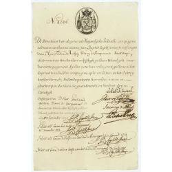
Very rare share in the Ostend Company.
Upper left hand corner share number 4526 in manuscript. In top emblem of the Ostend Company in copper engraving. Text: De Directeurs van de generale Keijserlijche- Indis...
Date: Antwerp / Ostend, 1723
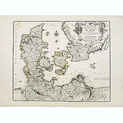
Le Royaume de Danemarc et les Etats.
Map centered on Sweden and North Germany.
Date: Paris, 1724
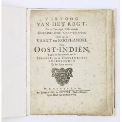
Vertoog van het regt, Dat de Vereenigde Nederlandsche Oost-Indische maatschappye Heeft op de Vaart en Koophandel naar Oost-Indiën, Tegen de inwooners van de Spaanse, nu de Oostenrykse Nederlanden.
Dutch translation of the Latin edition, published in 1723. Westerveen was the secretary of the Dutch East India Company and writes on the right of the VOC to trade as wel...
- $1200 / ≈ €1039
Date: Amsterdam, 1724
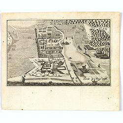
De Stad Macao.
A fine view of the city of Macao from Lappa Island showing the defenses, the forts, churches and convents: including Fort de Baare, Bon Parto, Fort St Paulo (Monte Fort)....
Date: Amsterdam, 1724
Platte Grond vande Stadt Macao.
A fine view of the city of Macao from Lappa Island showing in schematic blocks the structure of the town. With European vessels and junks in the surrounding water. With n...
Date: Amsterdam, 1724
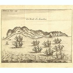
La rade d'Annobon.
Fine print of the arrival of the Dutch fleet by Cornelis Matelief de Jonge at Annobon, September 7th 1605. Cornelis Matelief de Jonge made a trip for the V.O.C. to the Ea...
- $100 / ≈ €87
Date: Amsterdam, J.F. Bernard, 1725
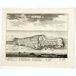
La ville et le fort de Gamma-Lamma dans l'isle de Ternate lequel fort apartient aux Espagnols.
A view of the town and fortress on the island of Ternate. The city was in the southern part of the island, in the place now called Kastela. From the French reissue of the...
- $100 / ≈ €87
Date: Amsterdam, J.F. Bernard, 1725
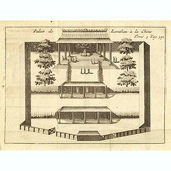
Palais de Lamthau à la Chine.
View of a Mandarin's Palace at Lantau Island, showing the palace wall, 3 gates and guards in the inner palace where the Mandarin meets with the officers.. Tome 3 Page 392...
- $75 / ≈ €65
Date: Amsterdam, J.F. Bernard, 1725
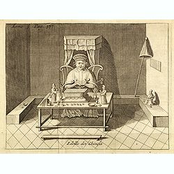
Idolle des Chinois.
Print of a Chinese divinity. Tome 3 Page 377 in upper left corner. From the French reissue of the account of early Dutch voyages first published in 1608 by Commelin. The ...
- $75 / ≈ €65
Date: Amsterdam, J.F. Bernard, 1725
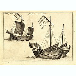
Jonques de la Chine.
A depiction of two Chinese junks. Tome 3 Page 377. From the French reissue of the account of early Dutch voyages first published in 1608 by Commelin. The French translati...
- $75 / ≈ €65
Date: Amsterdam, J.F. Bernard, 1725
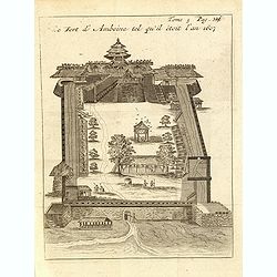
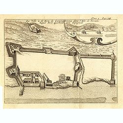
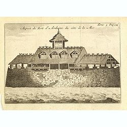
Le fort d'Amboine tel qu'il était en l'an 1607.
Fine plan of the Dutch fortress on Ambon Island which is part of the Maluku Islands of Indonesia. The island has an area of 775 km2 (299 sq mi).From the French reissue of...
- $75 / ≈ €65
Date: Amsterdam, J.F. Bernard, 1725
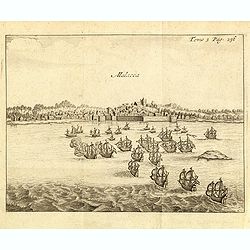
Malacca.
Fine print showing Dutch vessels offshore the city of Malacca and it is located 2 degrees north of the equator by the shore of the Straits of Malacca between Singapore to...
- $175 / ≈ €151
Date: Amsterdam, J.F. Bernard, 1725
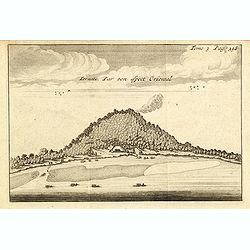
Ternate, par son aspect oriental.
This map is a view of Ternate with the summit of Gamalama from Dodoku Ali. From the French reissue of the account of early Dutch voyages first published in 1608 by Commel...
- $75 / ≈ €65
Date: Amsterdam, J.F. Bernard, 1725
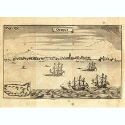
Ormus. (Hormuz)
Panoramic view of the town of Hormuz, with little inset map of the island. From the French reissue of the account of early Dutch voyages first published in 1608 by Commel...
- $200 / ≈ €173
Date: Amsterdam, F. Bernard, 1725
Le fort d'Amboine tel qu'il était en l'an 1607.
Fine depiction of the Dutch fortress on Ambon Island which is part of the Maluku Islands of Indonesia. The island has an area of 775 km2 (299 sq mi).From the French reiss...
- $80 / ≈ €69
Date: Amsterdam, J.F. Bernard, 1725
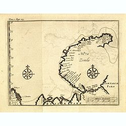
(Map of Nova Zembla with inset of Baye de Loms.)
Map of Nova Zembla with inset of Baye de Loms (5x7mm.).From the French reissue of the account of early Dutch voyages first published in 1608 by Commelin. The French trans...
- $100 / ≈ €87
Date: Amsterdam, F. Bernard, 1725
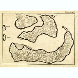
(Gunanappi / Wayer / Nera / Pulorin / Puloway .)
Uncommon map of islands in the Banda Sea. Several islands and villages are named, Wayer, Nera, Pulorin, Puloway, Lontoor, Ortattan and Combeer.From the French reissue of ...
- $75 / ≈ €65
Date: Amsterdam, F. Bernard, 1725
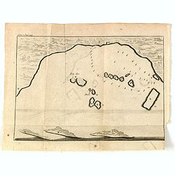
(Bird's eye view of the Bay of Bantam)
Early view of the Bay of Bantam with the islands of Pulo dua and Batto.Bantam was always a product of the ferocious commercial rivalry between the Dutch and English and P...
- $75 / ≈ €65
Date: Amsterdam, F. Bernard, 1725
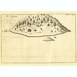
I. S. Clara.
Island "S. Clara" in Brazil just a few degrees north of the Tropic of Capricorn.From volume two of the French reissue of the account of early Dutch voyages. The...
- $100 / ≈ €87
Date: Amsterdam, F. Bernard, 1725
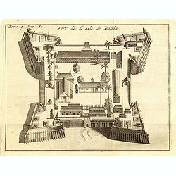
Fort de l'Isle de Banda.
Decorative print of the Dutch VOC fortress on the island Banda. Until the mid-19th century the Banda Islands were the world's only source of the spices nutmeg and mace, p...
- $90 / ≈ €78
Date: Amsterdam, F. Bernard, 1725
Porto il Desire.
Simplified bird's-eye view of Port Desire or Puerto Deseado in present-day Argentina.From volume two of the French reissue of the account of early Dutch voyages. The Fren...
- $150 / ≈ €130
Date: Amsterdam, F. Bernard, 1725
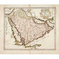
Arabiae Veteris.
A very striking map of the ancient Arabian Peninsula, embellished with an colored pictorial title cartouche.Read more about Mapping of Arabia and of Arabia and the Persi...
- $550 / ≈ €476
Date: Nuremberg, 1725
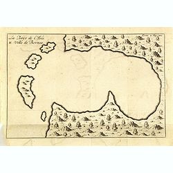
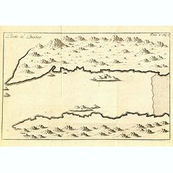
La Baye de l'Isle & ville de Borneo.
Uncommon map of a Bay on the island of Borneo. From the French reissue of the account of early Dutch voyages first published in 1608 by Commelin. The French translation w...
- $75 / ≈ €65
Date: Amsterdam, F. Bernard, 1725
Nova Persiae Armeniae Natoliae et Arabiae.
This fine map shows the area East from Cyprus to Iran, including The Saudi Peninsula, Red Sea, Nile River, Cyprus, Asia Minor, the Gulf of Aden, Indian Ocean, Armenia, th...
- $750 / ≈ €649
Date: Amsterdam, 1725
Batavia, L'an 1629.
Scarce town-view of Batavia (Jakarta) in 1629.From the French reissue of the account of early Dutch voyages first published in 1608 by Commelin. The French translation wa...
- $150 / ≈ €130
Date: Amsterdam, 1725