Browse Listings in Asia > South East Asia
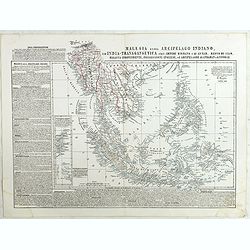
Malesia ossia Arcipelago Indiano, ed India-Transgangetica . . .
Attractive map of the Southeast Asia by a cartographer from Naples, listing his cartographic sources and giving political and statistical information on the areas covered...
Date: Naples, 1848
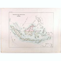
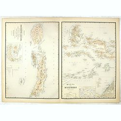
Vicariato aplico di Bataviaa E prefettura di Labuan nella Oceania.
Map showing the boundaries of Catholic dioceses in Southeast Asia in 1850s, with some detail of Java, Borneo, Sumatra. Including the Philippines, but without detail. This...
- $1000 / ≈ €874
Date: Rome, 1858-1859
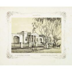
BATAVIA. Het post etablissement te Weltevreden. L'établissement des postes à Weltevreden.
Rare lithographed view of the post office at Weltevreden (Jakarta). Beautiful lithography drawn by Charles Th. Deeleman (1823 - 1884), lithographed by G.J. Bos and printe...
Date: Batavia, 1859-1860
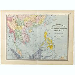
Carte de l'Asie orientale comprenant l'empire chinois le Japon les états de l'Indo-Chine et le grand archipel d'Asie ou Malaisie.
Detailed map of Malaysia, Thailand, China, Taiwan, and good detail in Philippines. Lower part of a 2-sheet map.
Date: Paris, 1862

Carte générale de la mer des Indes dressée par P. Daussy et P.E. Wissocq, grave par Chassant, ecrit par J.M. Hacq.
Magnificent and detailed large-scale chartdepicting the Indian ocean, with east coast of Africa, Madagascar, Arabian Peninsula, India, China, etc .Including the West coa...
- $1000 / ≈ €874
Date: Paris, 1837-1869
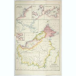
Borneo, shewing the lands ceded by the sultans of Brunei & Sulu to the British North Borneo Company.
Chromo lithographed folded map showing Borneo with Brunei, Sarawak, British North Borneo Company or Sabah. One of the first maps showing the British North Borneo Company ...
- $1750 / ≈ €1529
Date: London, Stanford, 1881
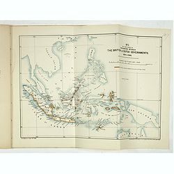
Papers relating to the affairs of Sulu and Borneo, and to the grant of a charter of incorporation of the British North Borneo Company. . . (with two folding maps of Indonesia)
58 pages Government recordings relating to the affairs of Sulu and Borneo, and to the grant of a charter of incorporation of the British North Borneo Company. . . (includ...
- $500 / ≈ €437
Date: London, Harrison and son, 1882
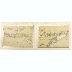
De kleine Soenda-Eilanden. Schaal van 1:800000.
Very detailed two sheet map of Soenda Islands, taken from "Atlas van Nederlandsch Oost- en West-Indie", prepared by doctor I. Dornseiffen, and published by publ...
- $30 / ≈ €26
Date: Amsterdam, Seyffardt, 1884
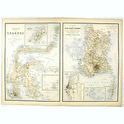
Kaart van Celebes / Kaart van Zuid-West-Celebes : bevattende de Gouvernem.ts, de leenroerige en een gedeelte der bondgenootschappelijke landen behoorende tot het Gouvernement van Celebes en onderh.
Very detailed map taken from "Atlas der Nederlandsche bezittingen in Oost-Indië", who was published by Departement van Koloniën".First edition of one of ...
- $50 / ≈ €44
Date: The Hague, 1883-1885
Kaart van't noordwestelijke gedeelte der Residentie Amboina . . . / Kaart der Molukken.
Two very detailed maps on one sheet, taken from "Atlas der Nederlandsche bezittingen in Oost-Indië", who was published by Departement van Koloniën".The m...
- $75 / ≈ €66
Date: The Hague, 1883-1885
![[Title page] Der Nederlandsche Bezittingen in Oost-Indië . . .](/uploads/cache/37336-250x250.jpg)
[Title page] Der Nederlandsche Bezittingen in Oost-Indië . . .
Decorative title page with, in the lower part, a schematic map of Indonesia, and two hemispheres. Taken from "Atlas der Nederlandsche bezittingen in Oost-Indië"...
- $75 / ≈ €66
Date: The Hague, 1883-1885
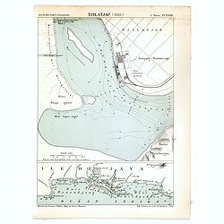
Tjilatjap (1888)
Detailed plan of the port and city of Tjilatjap on Java. Taken from "Atlas des Ports Etrangers". Lithographed by A. Simon.
Date: Paris, 1888
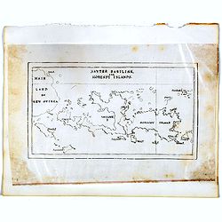
Hayter Basilisk, and Moresby Islands. (manuscript map)
An unusual small, and basic manuscript map of the Hayter Basilisk and Moresby Islands near Papua New Guinea, off the northern coast of Australia.
- $100 / ≈ €87
Date: London, ca. 1890
![Daily Telegraph War Map of The Far East. [No.11]](/uploads/cache/42244-250x250.jpg)
Daily Telegraph War Map of The Far East. [No.11]
A large and very detailed map of The Far East "Specially drawn for the Daily Telegraph by 'Geographia' Ltd". Printed in full color. Map extends from the norther...
- $125 / ≈ €109
Date: London, ca. 1940
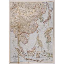
The Far East Compiled and Drawn in the Cartographic Section of the National Geographic Society for the National Geographic Magazine Gilbert Grosvenor. . .
Map of Far East Asia, with inset map of Korea. Scale 1:7.500.000. The first issue of National Geographic Magazine was published on September 22, 1888, nine months after t...
- $75 / ≈ €66
Date: Washington, 1952

Balinees watercolor on paper, fisherman.
Decorative export painting from Bali of a more than average quality.
- $150 / ≈ €131
Date: Bali, ca 1960

Balinees watercolor on paper, fishermen.
Decorative export painting from Bali of a more than average quality.
Date: Bali, ca 1960

Balinees watercolor on paper, fishermen.
Decorative export painting from Bali of a more than average quality.
- $150 / ≈ €131
Date: Bali, ca 1960
