Browse Listings in Asia > South East Asia
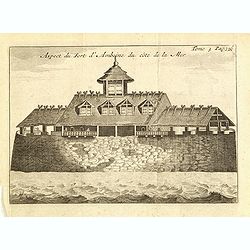
Le fort d'Amboine tel qu'il était en l'an 1607.
Fine depiction of the Dutch fortress on Ambon Island which is part of the Maluku Islands of Indonesia. The island has an area of 775 km2 (299 sq mi).From the French reiss...
- $80 / ≈ €70
Date: Amsterdam, J.F. Bernard, 1725
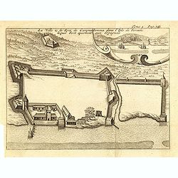
La ville et le fort de Gamma-Lamma dans l'isle de Ternate lequel fort apartient aux Espagnols.
A view of the town and fortress on the island of Ternate. The city was in the southern part of the island, in the place now called Kastela. From the French reissue of the...
- $100 / ≈ €87
Date: Amsterdam, J.F. Bernard, 1725
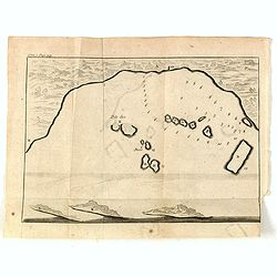
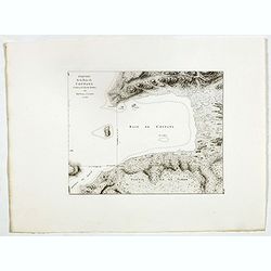
(Bird's eye view of the Bay of Bantam)
Early view of the Bay of Bantam with the islands of Pulo dua and Batto.Bantam was always a product of the ferocious commercial rivalry between the Dutch and English and P...
- $75 / ≈ €66
Date: Amsterdam, F. Bernard, 1725
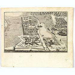
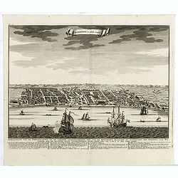
Batavia, L'an 1629.
Scarce town-view of Batavia (Jakarta) in 1629.From the French reissue of the account of early Dutch voyages first published in 1608 by Commelin. The French translation wa...
- $150 / ≈ €131
Date: Amsterdam, 1725
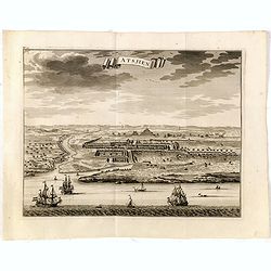
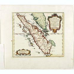
Astjien.
Nice bird's eye-view of the Town of Atjien on the northernmost point of Sumatra by François Valentijn (1666-1727), a missionary, who worked at Amboina from 1684 to 1694 ...
- $225 / ≈ €197
Date: Amsterdam, 1726
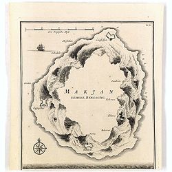
Makjan Geheel Bergagtig.
The island of Makian in Indonesia (formerly the Dutch East Indies) is represented on this map as a mountainous Möbius strip around a giant donut hole. François Valentij...
- $150 / ≈ €131
Date: Amsterdam, 1726
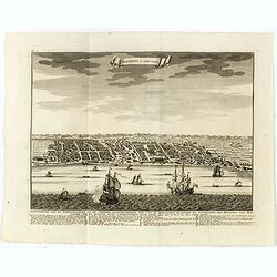
Samboepo in platte Grond.
Decorative panoramic view of the town of Samboupo on the island of Celebes (Sulawesi) in today's Indonesia. Dutch (V.O.C.) sailing ships and various local craft fill the ...
- $150 / ≈ €131
Date: Amsterdam, 1726
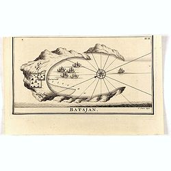
Batsjan. (Bacan)
Decorative panoramic view of Bay with the Dutch fortress Barneveld at the island of Bacan in today's Indonesia. Dutch (V.O.C.) sailing ships are illustrated.François Val...
- $45 / ≈ €39
Date: Amsterdam, 1726
Samboepo in platte Grond.
Decorative panoramic view of the town of Samboupo on the island of Celebes (Sulawesi) in today's Indonesia. Dutch (V.O.C.) sailing ships and various local craft fill the ...
- $150 / ≈ €131
Date: Amsterdam, 1726
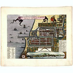
Plan de la Ville et du Chateau de Batavia en l'Isle de Iava / Ware affbeeldinge wegens het Casteel ende Stadt Batavia gelegen opt groot Eylant Java.
Detailed East-oriented plan of Jakarta former Batavia on Java / Indonesia. With a bird's eye view from seaside, various ships and a lion. Two inset keys with detailed des...
- $750 / ≈ €655
Date: Leiden, 1730
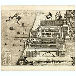
Plan de la Ville et du Chateau de Batavia en l'Isle de Iava / Ware affbeeldinge wegens het Casteel ende Stadt Batavia gelegen opt groot Eylant Java.
Detailed East-oriented plan of Jakarta former Batavia on Java / Indonesia. With bird's-eye view from sea side, various ships and a lion. Two inset keys with detailed desc...
Date: Leiden, 1730
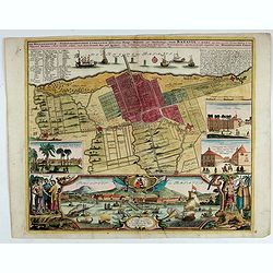
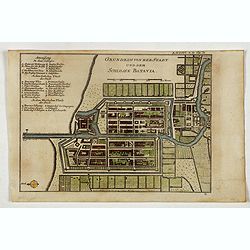
Der Hollaendisch-Ostindianischen Compagnie Weltberühmte Haupt - Handels und Niederlags stadt BATAVIA..
A very fine decorative plan of Batavia showing the City and its immediate environs, the surrounding rice fields intersected by a network of waterways, canals and outlying...
Date: Nuremberg, 1733
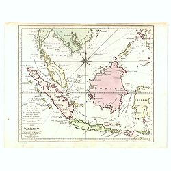
Carte des Isles de Java, Sumatra, Borneo. . . Malaca et Banca. . . / Kaart van de Eilanden van Java. . .
Dutch edition of this map of Indonesia prepared by N. Bellin and published by Pierre d'Hondt in Amsterdam. Jaques Nicolas Bellin (1703-1772) was one of the most important...
- $400 / ≈ €349
Date: Amsterdam, 1747
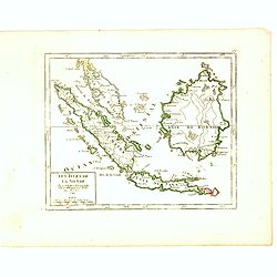
Les Isles de la Sonde Par le Sr. Robert de Vaugondy fils de Mr. Robert Geog. Ord du Roi avec Privilege 1749.
Small detailed map of of South East Asia, including Malaysian Peninsular with Singapore. From Atlas Portatif Universel, by Robert de Vaugondy.Page 170 outside border top...
Date: Paris, 1749
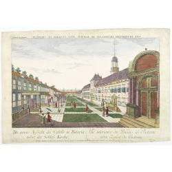
Die innere Aussicht des Castells in Batavia . . .
Showing the inside-square of the V.O.C. headquarters in Jakarta.The hand colored engraving is much perforated and the windows are cut out, a thin transparent paper is mou...
- $500 / ≈ €437
Date: Augsburg, 1750
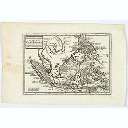
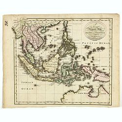
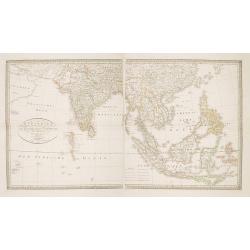
Archipel des indes Orientales
A finely engraved map depicting South East Asia with very good detail on the Philippines. Decorative title cartouche. From Atlas Universel of Gilles and Didier Robert de ...
Date: Paris, 1750
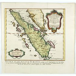
Carte de L'Isle de Sumatra Dressee sur les Journaux des Navigateurs . . .
Detailed map of Sumatra and Malacca, centered on Singapore and including the southern portion of the Malaysian peninsula. With "Detroit de Sincapour" and severa...
Date: Paris, ca. 1750
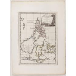
The Philippine Islands and others of the East Indies. . .
Herman Moll's 'busy' map of South East Asia and the Philippines, published in the middle of the eighteenth century in London. The map includes numerous small islands, Sum...
- $280 / ≈ €245
Date: London, ca 1750
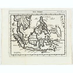
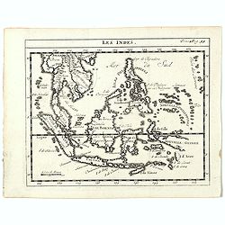
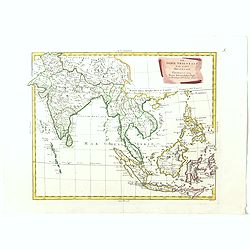
Les Indes.
Scarce small map of South East Asia with Indonesia, Thailand, Philippines and including New Guinee, based on cartography of Guillaume Delisle. Published in "Nouveau ...
- $125 / ≈ €109
Date: Paris, La veuve Lottin & Butard, P.G. Le Mercier, Rollin, 1751
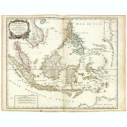
Carte Des Isles de Java, Sumatra, Borneo.. Malaca et Banca..
Jacques Nicolas Bellin (1703-1772) was one of the most important and proficient French cartographers of the mid-eighteenth century. He was appointed the first Ingenieur H...
- $300 / ≈ €262
Date: Paris, 1752
Les Indes.
A scarce small map of Southeast Asia, including Indonesia, Thailand, the Philippines, and New Guinea, based on the cartography of Guillaume Delisle. Published in "No...
- $200 / ≈ €175
Date: Paris, ca. 1752
Carte de l'Isle de Sumatra. . . / Kaart van het Eiland Sumatra. . .
Map of Sumatra, also showing the tip of the Malay Peninsula and the Straits of Singapore. An unusually detailed map of the area, showing many coastal features, shoals, ba...
Date: The Hague, Pierre d'Hondt, 1753
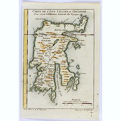
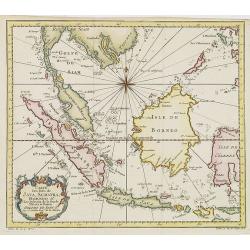
Carte de L'Isle Celebes ou Macassar.
A fine little copper engraved map of Celebes Island, Makassar.It is the provincial capital of South Sulawesi, Indonesia. It is the largest city on Sulawesi Island in term...
- $60 / ≈ €52
Date: Paris, 1754
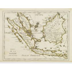
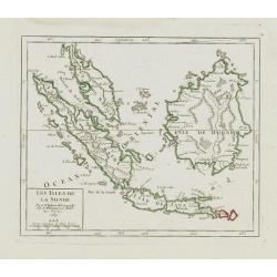
Isles de la Sonde.
Fine map of the islands of Java, Sumatra, Borneo, Bali and part of the Malay peninsular. George Louis Le Rouge was active from 1740- till 1780 as a publisher, and was app...
- $200 / ≈ €175
Date: Paris, 1756
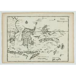
Isles Moluques.
A scarce little map depicting European knowledge of Sulawesi, part of Borneo and the Spice Islands at the time of publication.George Louis Le Rouge was active from 1740- ...
Date: Paris, 1756
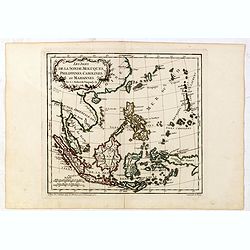
Les Isles de la Sonde, Moluques, Philippines, Carolines, et Marlannes.
Nice detailed map of southeast Asia, showing the Malay Peninsula, Sumatra, Java and the island of Borneo. Engraved by E. Dussy and the title cartouche by Arrivet. From hi...
- $275 / ≈ €240
Date: Paris, ca. 1762
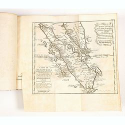
Histoire universelle depuis le commmencement du monde jusqu'a present. Tome Vingt-unieme. Portugais, Espagnols, Hollanois etc
Volume 21 of this informative publication with a description of the discoveries, conquests, and settlements by the Portuguese, Spaniards, English, and Dutch in Southeast ...
- $1200 / ≈ €1048
Date: Amsterdam, Leipzig, 1763
Les Isles de la Sonde.
Small detailed map of southeast Asia, showing the Malay Peninsula, Sumatra, Java and the island of Borneo. Dated 1769.From Atlas Portatif Universel, by Robert de Vaugondy...
- $200 / ≈ €175
Date: Paris, later than 1769
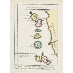
Carte Particuliere des Isles Moluques.
A very nice map centered on the island of the Moluccas.From Atlas Portatif pour servir a l'intelligence de l'Histoire Philosophique et Politique des etablissements et du ...
- $75 / ≈ €66
Date: Amsterdam, 1773
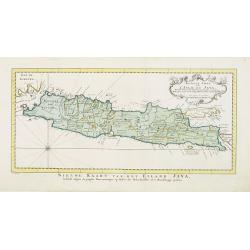
Nouvelle carte de l'Isle de Java.
A very nice map centered on the island of Java. With French text in title cartouche and an additional title in Dutch underneath the map.Read more Early maps of South East...
Date: Amsterdam, 1773
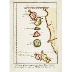
Carte Particuliere des Isles Moluques. . .
A very nice map centered on the island of the Moluccas.Title in French and in Dutch underneath the map.
Date: Amsterdam, 1773
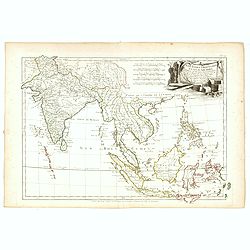
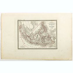
Les Indes Orientales et leur Archipel. . .
General map of Indonesia, extending from India to the Philippines and New Guinea.Ornated with a decorative title cartouche. Boundaries outlined in hand color.From theAtla...
- $250 / ≈ €218
Date: Paris, ca 1783
Plan der Stad en ‘t Kasteel BATAVIA. Aanwyzing der Stad en Kasteels Punten.
Very fine decorative plan of present-day Jakarta, showing the City and its immediate environs, the surrounding rice fields intersected by a network of waterways, canals a...
- $1750 / ≈ €1529
Date: Amsterdam, 1782-1783
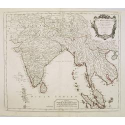
Les Indes Orientales.. tirées du Neptune Oriental..
Finely and crisply engraved map centered on the Bay of Bengal, encompassing the Indian subcontinent and the Indochinese Peninsula.Venetian edition of Giles Didier Robert ...
- $450 / ≈ €393
Date: Venice, 1779 - 1784
![[Set of 4 maps] Indie Orientali di Quà e di la Dal Gange col Loro Arcipelago.](/uploads/cache/36680-250x250.jpg)
[Set of 4 maps] Indie Orientali di Quà e di la Dal Gange col Loro Arcipelago.
Fine almost wall sized map of South east Asia, including Formosa, New Guinea, the Maldives and the Indus delta. From his "Atlante Novissimo, illustrato ed accresciut...
- $850 / ≈ €743
Date: Venice, ca. 1779 - 1785
![Indie Orientali di Quà e di la Dal Gange col Loro Arcipelago. [Set of 4 maps]](/uploads/cache/43240-250x250.jpg)
Indie Orientali di Quà e di la Dal Gange col Loro Arcipelago. [Set of 4 maps]
Fine almost wall sized map of South east Asia, including Formosa, New Guinea, the Maldives and the Indus delta. From his "Atlante Novissimo, illustrato ed accresciut...
Date: Venice, ca. 1779 - 1785
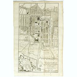
Grundriss von der Stadt und dem Schlosse Batavia.
Uncommon plan of the town and fortress of Batavia. The plan is based on the earlier, much larger map of Batavia published by Clement de Jonghe in 1650. From 'Algemeine We...
- $175 / ≈ €153
Date: Halle, 1763-1792
Le Indie Orientali E Il Loro Arcipelago . . .
Striking map of the region from the Gulf of Bengal to Hainan, centered on the Malay Peninsula, Straits of Malacca, Sumatra, Java and Philippines.This is the uncommon edit...
- $500 / ≈ €437
Date: Venise, 1794-1796
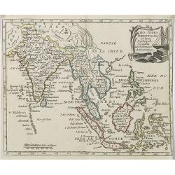
A new and Accurate map of the islands and Channels between China and New Holland.
Highly detailed map of Southeast Asia, covering the region between Formosa and Hainan islands in the North and Australia in the South.Including Burma to Taiwan with parts...
- $600 / ≈ €524
Date: Edinburgh, 1801
Les Indes Orientales et leur Archipel . . .
Map of India, the Maldive Islands, the Indonesian and Philippine Islands, from Atlas moderne portatif composé de vingt-huit cartes sur toutes les parties du globe terres...
- $300 / ≈ €262
Date: Paris, Prudhomme, Levrault, Debray, 1806
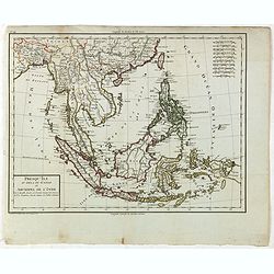
Presqu'Île au dela du Gange et Archipel de l'Inde.
Detailed map of Indonesia with Philippines and Taiwan. Engraved by P.F.Tardieu. From "Mentelle's Atlas Universe".
- $150 / ≈ €131
Date: Paris, ca 1784 / 1806
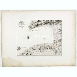
Esquisse de la Baie de Coupang (cote S.O. Ile de Timor) par M. M. Peron et Lesueur, an 1803.
Map of Kupang Bay on the Indonesian Island Timor, prepared by Louis Freycinet during his voyage under Captain Thomas Baudin in 1800-1803. Plate no. 14 from the atlas part...
- $100 / ≈ €87
Date: Paris, Langois, 1811
Esquisse de la Baie de Coupang (cote S.O. Ile de Timor) par M. M. Peron et Lesueur, an 1803.
Map of Kupang Bay on the Indonesian Island Timor, prepared by Louis Freycinet during his voyage under Captain Thomas Baudin in 1800-1803. Plate no. 14 from the atlas part...
- $150 / ≈ €131
Date: Paris, Langois, 1811
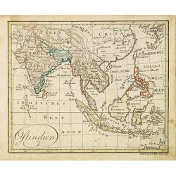
Ostindien.
Nice small map of South East Asia published by Johannes Walch in his rare Allgemeiner Atlas Nach den bewährsten Hülfsmitteln und astronomischen Ortsbestimungen…, edit...
- $160 / ≈ €140
Date: Augsburg, 1812
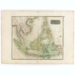
East India Isles.
Somewhat later but very finely engraved and detailed map of the Indonesian archipelago, including Thailand, Philippines and southern part of Taiwan.
Date: Edinburgh, 1817
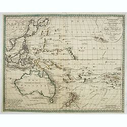
Australien (Südland) auch Polynesien oder Inselwelt..
SECOND EDITION of the Johann Walch map of Australasia and the South Pacific. Australia lettered Neu Holland, the name given to it by Able Tasman that was still in use un...
Date: Augsburg, 1802-1820
Charte von Ostindien Diesseits Und Jenseits Des Ganges / nach den neuesten astronomischen Beobachtungen auch andern sichern Hülfsmitteln neu entworfen. . .
Prepared by I.C.M.Reinecke giving good detail in India, Indonesia and the Philippines.
- $800 / ≈ €699
Date: Weimar, 1822

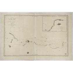
Eastern passage to China. sheet 1.
James Horsburgh early chart of the coasts of Java, Bali, Lombok, with part of Sulawesi, and Borneo. Insets of "Sketch of Bally Strait", Sketch of Lombock Strait...
- $2500 / ≈ €2184
Date: London, 1824
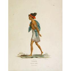
Timor - Malais libre.
A fine color plate from the rare travel book: Voyage de découvertes aux terres Australes . The Baudin voyage from 1800-1804 was the most successful French scientific exp...
- $100 / ≈ €87
Date: Paris, Langlois, 1824
![Timor. Naba-Leba, Roi de L'Ile Solor. [plate XXV]](/uploads/cache/40114-250x250.jpg)
Timor. Naba-Leba, Roi de L'Ile Solor. [plate XXV]
Nicely colored portrait of the King of Solor, or Timor in South East Asia.After the original sketches by Lesueur, from Voyage de découvertes aux terres Australes by Fran...
- $100 / ≈ €87
Date: Paris, 1824
![[Sumatra plants ].](/uploads/cache/25837-250x250.jpg)
[Sumatra plants ].
Aquatint depicting coffee, pepper et other plants in Sumatra. Plate N° 46.From Giulio Ferrario's work Le Costume Ancien et Moderne ou Histoire du gouvernement, de la mil...
- $50 / ≈ €44
Date: Milan, 1827
![[No title]. [Two locals of the island of Ubi ].](/uploads/cache/25845-250x250.jpg)
[No title]. [Two locals of the island of Ubi ].
Aquatint depicting two locals, one rowing to shore, the other searching for sea shells on the Island of Ubi in the Moluccas. Engraved by Carlo Bottigella. From Giulio Fer...
- $40 / ≈ €35
Date: Milan, 1827
![[ Island of Bouro with a view of Cayeli ].](/uploads/cache/25846-250x250.jpg)
[ Island of Bouro with a view of Cayeli ].
Aquatint depicts a view of Cayeli on the island of Bouro. Engraved by G.Castellini. Plate N° 55.From Giulio Ferrario's work Le Costume Ancien et Moderne ou Histoire du g...
- $50 / ≈ €44
Date: Milan, 1827
![[ A man and woman from Timor ].](/uploads/cache/25847-250x250.jpg)
[ A man and woman from Timor ].
Aquatint depicting a man and woman from Timor, engraved by A.Biasioli. Plate N° 56. The weaving of traditional scarves or tais is widespread in East Timor. From Giulio...
- $50 / ≈ €44
Date: Milan, 1827
![[Abiti degli isolani di Pogghy ].](/uploads/cache/34989-250x250.jpg)
[Abiti degli isolani di Pogghy ].
Aquatint depicting a couple of the island of Pogghy engraved by DK. Bonatti. Plate N°42.From Giulio Ferrario's work Le Costume Ancien et Moderne ou Histoire du gouvernem...
- $50 / ≈ €44
Date: Milan, 1827
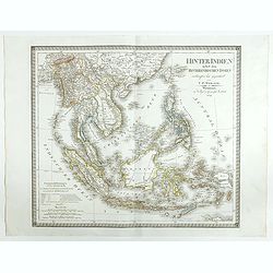
Hinter Indien nebst den Hinterindischen Inseln entwrfen und Gezeichnet von C.F. Weiland . . . 1828
Scarce map of Southeast Asia, including southern China, the Philippines, the Malaysian Peninsula and extending south to Java, Timor and the northern tip of Australia.The ...
- $300 / ≈ €262
Date: Weimar, 1829
Banjowangui.
Early view of Banjowangui on the island of Java. Engraved in aquatint technique by Sigismond Himely (1801-1872) after Lauvergne. Published as plate 61 in Voyage autour du...
- $150 / ≈ €131
Date: Paris, Finot, 1835
Rivière de Sourabaya.
Early view of Surabaya on the island of Java after Paris and engraved in aquatint technique by Sigismond Himely (1801-1872). Published as plate 61 in Voyage autour du mon...
- $300 / ≈ €262
Date: Paris, Finot, 1835
Carte de la Malaisie ou Grand archipel d'Asie.
Nice map of Indonesia, Philippines, Malacca with Singapore and tip of Northern Australia. Engraved by Thierry. Countries and regions in delicate out line color. Includes ...
Date: Paris, 1835
Le Insole della Sonda
Cassini’s splendid early map of Philippines, and Indonesia..Taken from the ""Nuovo Atlante Geografico Universale delineato sulle ultime osservazioni", pu...
Date: Rome, Calcography, 1797-before 1839
Carte de la Partie Nord-Ouest de' l'Ile de Java. . . Pl. 33. N° 1086.
Sea chart depicting the north west part of the Island of Java, up to Batavia (present-day Jakarta). Also an inset chart of part of the Java coast line.Prepared by Clémen...
Date: Paris, 1839
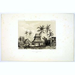
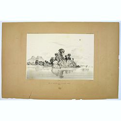
Village de Warrou.
Lithograph of the small settlement of Waru on the island of Seram in Indonesia. Plate 127, taken from the "Voyage au Pole Sud et dans L'Oceanie…." Departing i...
- $50 / ≈ €44
Date: Paris, 1842
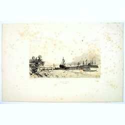
Rade d'Amboine.
A peaceful lithograph of ships and boats at anchor in Ambon Island, located in the archipelago of the Moluccas in Indonesia. Plate 108 taken from the 'Voyage au Pole et d...
- $35 / ≈ €31
Date: Paris, 1842
Mosquee du Village de Warou.
A lithograph of the mosque in the village of Waro, on the Indonesian island of Seram. Plate 128 taken from the 'Voyage au Pole et dans L'Oceanie…' Departing in late 183...
- $100 / ≈ €87
Date: Paris, 1842
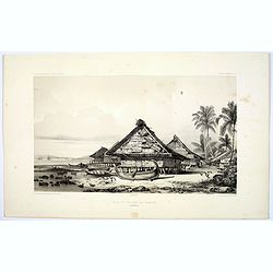
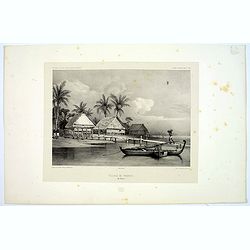
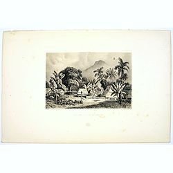
Rade et Village de Warrou.
An impressive lithograph of the dwellings to be found in the village of Waru, on the Indonesian island of Seram. Plate 126 taken from the 'Voyage au Pole et dans L'Oceani...
- $100 / ≈ €87
Date: Paris, 1842
Site sur la Cote de Sumatra.
A lovely lithograph of a small settlement somewhere along the coast of Sumatra. Plate 154 taken from the 'Voyage au Pole et dans L'Oceanie…' Departing in late 1837 in t...
- $100 / ≈ €87
Date: Paris, 1842
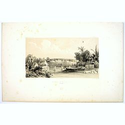
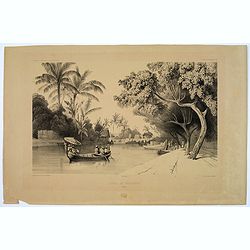
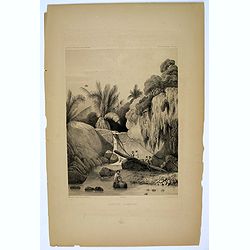
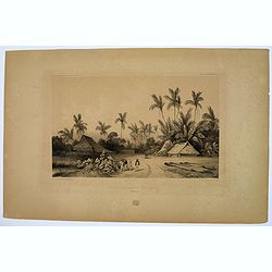
Riviere de Batou-Mera.
A lithograph of a simple bridge crossing the Batou-Mera river on the island of Ambone in the Moluccas, part of the Indonesian archipelago. Plate 110 taken from the 'Voyag...
- $100 / ≈ €87
Date: Paris, 1842
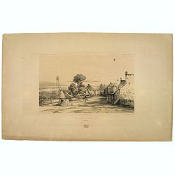
Une rue de Macassar.
A pretty lithograph of a street scene in the village of Makassar, on the southern edge of the Indonesian island of Sulawesi, formerly the Celebes Island. Plate 130 taken ...
- $30 / ≈ €26
Date: Paris, 1842
Une rue du Quartier Malais a Macassar.
An attractive lithograph of the Malay living quarters in the southern village of Makassar in Sulawesi, formerly the Celebes island in Indonesia. Plate 131 taken from the ...
- $30 / ≈ €26
Date: Paris, 1842
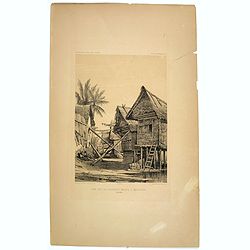
Case de Pecheurs dans la riviere Sambas.
A fishing hut seen along the Sambas River in Borneo. Plate 137 taken from the 'Voyage au Pole et dans L'Oceanie…' Departing in late 1837 in the Astrolabe and Zélée, D...
- $30 / ≈ €26
Date: Paris, 1842
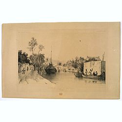
Canal de Samarang.
A tranquil lithograph showing a wealthy man being gently rowed up the canal in Semerang, on the Indonesian island of Java Plate 148 taken from the 'Voyage au Pole et dans...
- $50 / ≈ €44
Date: Paris, 1842
Site sur les bords du canal de Samarang.
A lithograph showing a Canalside scene of activity in the northeastern Javanese city of Semarang. Plate 149 taken from the 'Voyage au Pole et dans L'Oceanie…' Departing...
- $50 / ≈ €44
Date: Paris, 1842
Quartier Malais a Samarang.
A fine lithograph depicting the Malay quarter in the north eastern Javanese city of Semarang in Indonesia. Plate 150 taken from the 'Voyage au Pole et dans L'Oceanie…' ...
- $75 / ≈ €66
Date: Paris, 1842
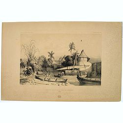
Aiguade d'Amboine.
Men with barrels in a river on the Indonesian island of Ambone. Plate112 taken from the 'Voyage au Pole et dans L'Oceanie…' Departing in late 1837 in the Astrolabe and ...
- $40 / ≈ €35
Date: Paris, 1842
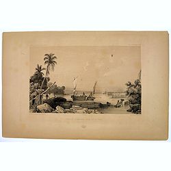
Rade de Ternate.
A peaceful harbour scene on the Moluccan island of Ternate in Eastern Indonesia. Plate 106 taken from the 'Voyage au Pole et dans L'Oceanie…' Departing in late 1837 in ...
- $50 / ≈ €44
Date: Paris, 1842
Entrée du Canal de Samarang.
A lovely lithograph of the canal entrance to the north eastern city of Semarang, on the Indonesian island of Java. Plate 147 taken from the 'Voyage au Pole et dans L'Ocea...
- $50 / ≈ €44
Date: Paris, 1842
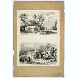
Tombeaux Malais pres de Coupang.
A lithograph displaying a pair of funeral monuments of both the Chinese and Malays, on the Indonesian island of Timor. Plate 192 taken from the 'Voyage au Pole et dans L'...
- $30 / ≈ €26
Date: Paris, 1842
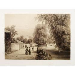
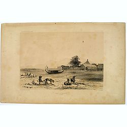
Ancien Etablissement Hollandais.
An ancient Dutch settlement in S.E. Asia. Plate123 taken from the 'Voyage au Pole et dans L'Oceanie…' Departing in late 1837 in the Astrolabe and Zélée, Dumont D'Urvi...
- $50 / ≈ €44
Date: Paris, 1842
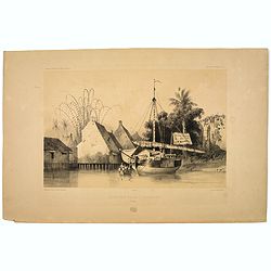
Aiguade d'Amboine pres de la Mer.
A lithograph of sailors unloading stores from a small sail boat in a tropical bay on the island of Amboina in Indonesia. Plate 112 taken from the 'Voyage au Pole et dans ...
- $50 / ≈ €44
Date: Paris, 1842
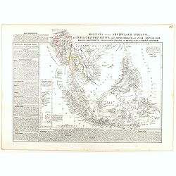
Malesia ossia Arcipelago Indiano, ed India-Transgangetica.
Attractive map of the Southeast Asia by a cartographer from Naples, listing his cartographic sources and giving political and statistical information on the areas covered...
- $500 / ≈ €437
Date: Naples, 1848
