Browse Listings in America
![[How the Indians cross the river.]](/uploads/cache/40477-250x250.jpg)
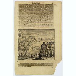
[How the Indians cross the river.]
The Indians of Peru had strange ways of crossing rivers. They tied a rope between two poles on either side of a river, then they hung a large basket from this rope and wh...
Date: Frankfurt, M.Merian, 1633
![[How the women tease their captives.]](/uploads/cache/40478-250x250.jpg)
[How the women tease their captives.]
The Indian women led their captive, Staden, into the middle of the hamlet. Then they decorated his head with feathers and his legs with rattles. After forming a circle ro...
Date: Frankfurt, M.Merian, 1633
![[Columbus lands on the Island of San Salvador.]](/uploads/cache/40479-250x250.jpg)
[Columbus lands on the Island of San Salvador.]
On 12th October 1492, after 33 days at sea, Columbus sighted land. His three ships made their way round the south-west point of an island Columbus named San Salvador - be...
- $100 / ≈ €87
Date: Frankfurt, M.Merian, 1633
![[Collective suicide under Spanish rule.]](/uploads/cache/40480-250x250.jpg)
[Collective suicide under Spanish rule.]
The natives of Hispaniola, who saw no end to the fearful oppression of Spanish rule, preferred death. So many, devoid of all hope, went into the woods to kill their child...
- $80 / ≈ €70
Date: Frankfurt, M.Merian, 1633
![[The strange sheep-like creatures that carried the silver .]](/uploads/cache/40481-250x250.jpg)
[The strange sheep-like creatures that carried the silver .]
When the Spanish discovered the silver mines of Potosí, they organised the transporting of the rich ore, westward by llama trains across the Altiplano and down to Arica ...
- $80 / ≈ €70
Date: Frankfurt, M.Merian, 1633
![[How the Indians mined the silver at Pitosi.]](/uploads/cache/40482-250x250.jpg)
[How the Indians mined the silver at Pitosi.]
The mountain shown here is probably the Cerro Rico, which stand above the city of Potosí and has the distinction of being the richest mountain in all the Americas. The I...
- $100 / ≈ €87
Date: Frankfurt, M.Merian, 1633
![[How the Indians cured the Spanish thirst for gold....by pouring it down their throats!]](/uploads/cache/40483-250x250.jpg)
[How the Indians cured the Spanish thirst for gold....by pouring it down their throats!]
A brutal scene depicting native Indians tying down Spanish men and pouring liquid gold down their throats. Scenes of cannibalism in the background.In 1631 Johann Ludwig G...
Date: Frankfurt, M.Merian, 1633
![De Sota meets the Inca king near Cajamarca.]](/uploads/cache/40485-250x250.jpg)
De Sota meets the Inca king near Cajamarca.]
When the Spanish arrived in Cajamarca, they found only a few inhabitants. The Inca army was camped in the surrounding hills and the residence of the Inca king, Atahualpa,...
Date: Frankfurt, M.Merian, 1633
![[Vespucci lands on the Island of Itius.]](/uploads/cache/40486-250x250.jpg)
[Vespucci lands on the Island of Itius.]
According to the esteemed historian, Las Casas,‘Itius cannot be other than the islands we reach coming from Spain, named Guadeloupe and Dominica.When Vespucci and his S...
Date: Frankfurt, M.Merian, 1633
(Native population of Tierra del Fuego attacking some Dutchmen)
Native population of Tierra del Fuego attacking some Dutchmen. In the background anchored ships. Illustrating the account of the expedition of Jacobus L'Hermite.With nati...
- $100 / ≈ €87
Date: Frankfurt, M.Merian, 1633
![Praelium Divrnum. [Spanish fleet defeated by the Dutch] / Nocturnum Praelium [Dutch and Spanish at sea off Lima].](/uploads/cache/41087-250x250.jpg)
Praelium Divrnum. [Spanish fleet defeated by the Dutch] / Nocturnum Praelium [Dutch and Spanish at sea off Lima].
Two engravings. [498] On the evening of 17th July, 1615, Spilbergen’s Dutch fleet encountered, off the coast of Peru near Lima, the powerful fleet of the Spanish, under...
Date: Frankfurt, M.Merian, 1633
![[Spilbergen's fleet visits the island of Santa Maria] / [The Dutch visit Isla Mocha].](/uploads/cache/41090-250x250.jpg)
[Spilbergen's fleet visits the island of Santa Maria] / [The Dutch visit Isla Mocha].
Two engravings. [514] On 29th May, 1615, Spilbergen’s fleet anchored further north, off an island called Santa María that was separated by a narrow stretch of water (A...
Date: Frankfurt, M.Merian, 1633
![[Spanish take over Cusco] / [Atahualpa is garrotted].](/uploads/cache/41092-250x250.jpg)
[Spanish take over Cusco] / [Atahualpa is garrotted].
Two engravings. [486] After Atahualpa was killed, Pizarro set out with his troops to find the city of Cuzco, which he had heard was rich in gold. The journey from Cajamar...
Date: Frankfurt, M.Merian, 1633
![[The bloody battle at Chupas] / [Francesco Pizzaro is killed].](/uploads/cache/41093-250x250.jpg)
[The bloody battle at Chupas] / [Francesco Pizzaro is killed].
Two engravings. [492] Even before Pizarro’s death, a new royal governor, Vaca de Castro, was on his way to settle the turmoil in Peru. He refused to accept Almagro the ...
Date: Frankfurt, M.Merian, 1633
![[How the Inca nobility are buried] / [Bridge of Huaynacapaco]](/uploads/cache/41094-250x250.jpg)
[How the Inca nobility are buried] / [Bridge of Huaynacapaco]
Two engravings. [470] The funeral of an Inca king was a ceremony of great splendor. After digging a large pit, the Indians would decorate the corpse with gold and silver ...
Date: Frankfurt, M.Merian, 1633
![[How natives of Paria cope with illness] / Vespucci reaches Lake Maracaibo]..](/uploads/cache/41095-250x250.jpg)
[How natives of Paria cope with illness] / Vespucci reaches Lake Maracaibo]..
Two engravings. [421b] When the natives of those parts, they were bathed in a cold stream, then chased round a blazing fire until they had dried out. Then they were put t...
Date: Frankfurt, M.Merian, 1633
![[A prisoner of the Indians of Tupinamba, covered in feathers . . .]](/uploads/cache/41101-250x250.jpg)
[A prisoner of the Indians of Tupinamba, covered in feathers . . .]
A graphic scene of fighting and extreme violence. One man is seen covered in feathers, before being sacrificed and killed before the Brazilian tribe of Tupinamba. In 1631...
Date: Frankfurt, M.Merian, 1633
![[Another Dutch fleet reaches Lima].](/uploads/cache/41117-250x250.jpg)
[Another Dutch fleet reaches Lima].
In 1624 a heavily armed Dutch fleet sailed from the Juan Fernandez Islands to Lima. The leader of the fleet, Jacob l’Hermite, was in such poor health that he had to han...
Date: Frankfurt, M.Merian, 1633
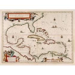
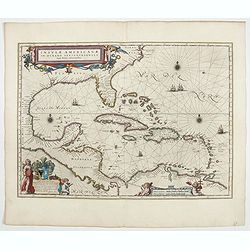
Insulae Americanae in Oceano Septentrionali cum Terris adiacentibus.
General map of the West Indies extending from Virginia to the mouth of the Orinoco, and destined to be copied in various shapes by many other publishers. Title cartouche ...
- $1000 / ≈ €874
Date: Amsterdam, 1635
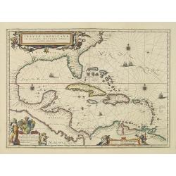
Insulae Americanae in Oceano Septentrionali cum Terris adiacentibus.
General map of the West Indies extending from Virginia to the mouth of the Orinoco, and destined to be copied in various shapes by many other publishers.Title cartouche t...
- $1800 / ≈ €1572
Date: Amsterdam, 1638
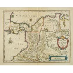
Terra Firma et Novum regnum Granatense et Propayan.
Fine copy, with wide margins of this handsome map of the Isthmus of Panama and northwestern South America including most of present day Columbia and part of Venezuela. Te...
- $400 / ≈ €349
Date: Amsterdam, 1640
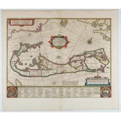
Mappa Aestivarum Insularum, alias Barmudas...
This magnificent map is based on the famous survey by John Norwood of the Bermuda Company in 1618. The map shows the division into the original Tribes and shows the vario...
- $1700 / ≈ €1485
Date: Amsterdam, 1640

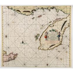
Venezuela cum parte Australi novae Andalusiae.
RARE. A finely engraved, decorative map with no text on the verso. The islands Trinidad, Margarita, Aruba and Curaçao are shown as well.
Date: Amsterdam, c. 1640
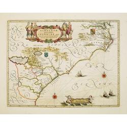
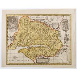
Virginiae Partis Australis, et Floridae Partis Orientalis.
Blaeu based this map on the Mercator-Hondius of 1606. A number of geographical improvements, however were incorporated, although two large fictions lakes accompanied by e...
- $1400 / ≈ €1223
Date: Amsterdam, 1640
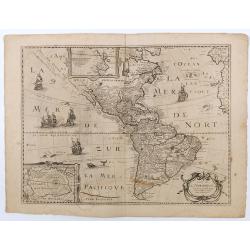
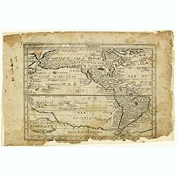
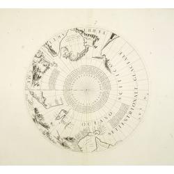
Carte de l'Amérique, corrigée et augmentée…1640.
State 2. Re-edition of the map by Bertius of 1624, the name of Bertius removed and dated 1640. Inset maps of the Arctic and Antarctic. The map is based on the Jodocus Hon...
Date: Amsterdam, 1640
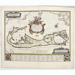
Mappa Aestivarum Insularum alias Barmudas.
Blaeu based his work on John Speed's remarkably accurate map of 1626-1627. It shows the island divided into tribes and lots, and below the map itself appear the names of ...
- $2000 / ≈ €1747
Date: Amsterdam, 1644
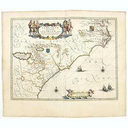
Virginiae Partis Australis, et Floridae Partis Orientalis.
Blaeu based this map on the Mercator-Hondius of 1606. A number of geographical improvements, however were incorporated, although two large fictions lakes accompanied by e...
- $1500 / ≈ €1310
Date: Amsterdam, 1644
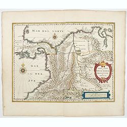
Terra Firma et Novum regnum Granatense et Propayan.
Handsome map of the Isthmus of Panama and north-western South America, including most of present day Columbia and part of Venezuela.Terra Firma is Panama, Veragua is Cost...
- $350 / ≈ €306
Date: Amsterdam, ca. 1644
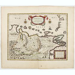
Venezuela cum parte Australi Novae Andalusiae.
A finely engraved, decorative map of Venezuela. The islands of Trinidad and Tobago, Margarita, Aruba and Curaçao are shown. Local animals are depicted, sheep, birds, mon...
- $800 / ≈ €699
Date: Amsterdam, ca. 1644
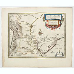
Paraguayo prov. de Rio de La Plata cum regionibus..
A beautiful map of Paraguay, and parts of Peru, Chile, Argentina, Brazil and Bolivia. Much of the area was still "Terra Incognita" so there are few towns and ci...
- $600 / ≈ €524
Date: Amsterdam, 1644
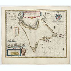
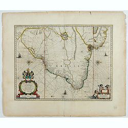
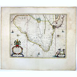
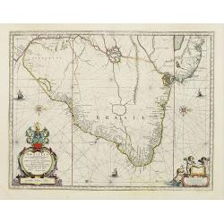
Tabula Magellanica.
A map with Willem Blaeu's signature, but published by his son Joan, of South America's extremity. A dedication to Constantijn Huygens. From early on Willem Jansz. Blaeu ...
- $1000 / ≈ €874
Date: Amsterdam, 1644
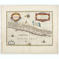
Chili.
Willem Blaeu's very decorative map of Chili with two large and beautiful cartouches, a compass and ships. From early on Willem Jansz. Blaeu aimed of publishing an atlas ...
- $900 / ≈ €786
Date: Amsterdam, 1644
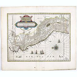
Peru.
FIRST EDITION, FIRST ISSUE OF THIS MAP. Decorated with ships and monsters in the sea. Orientated with east at the top. With the signature of G. Blaeuw lower right corner....
- $900 / ≈ €786
Date: Amsterdam, 1644

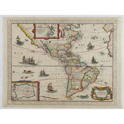
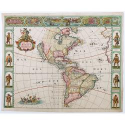
Americae Nova Tabula.
An inset shows Greenland and Iceland. Decorative elements include ships, sea monsters, and vignettes of native Americans within South America. In addition, the map is bor...
- $6500 / ≈ €5678
Date: Amsterdam, 1644
Insulae Americanae in Oceanus Septentrionali cum Terris..
General map of the West Indies extending from Virginia to the mouth of the Orinoco, and destined to be copied in various shapes by many other publishers.Title cartouche t...
- $2500 / ≈ €2184
Date: Amsterdam, 1644
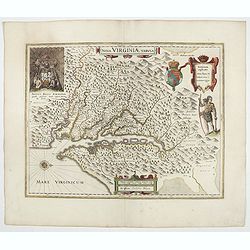
Nova Virginiae Tabula.
The map is based on the first state of Smith's map, 1612, and is slightly larger and more expertly engraved. In 1629 the Hondius plate was purchased by Blaeu who deleted ...
Date: Amsterdam, 1644
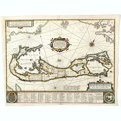
Mappa Aestivarum Insularum, alias Barmudas..
Based closely on Blaeu's map of 1630 but with a simpler centered title piece. The map includes the arms of Bermuda and England, and lists proprietors of the various tribe...
Date: Amsterdam, 1645
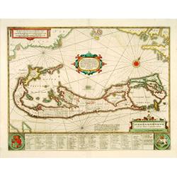
Mappa Aestivarum Insularum, alias Barmudas. . .
It shows the island divided into tribes and lots, and below the map itself appear the coats of arms of Bermuda and England and the names of the first proprietors and the ...
Date: Amsterdam, 1645
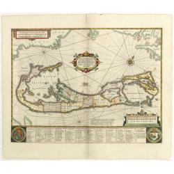
Mappa Aestivarum Insularum, alias Barmudas.
This magnificent map is based on the famous survey by John Norwood of the Bermuda Company in 1618. The map shows the division into the original Tribes and shows the vario...
- $2000 / ≈ €1747
Date: Amsterdam, 1645
Brasilia.
Fine copy of this map by Krystof Arciszewski, a Polish general who worked for the Dutch West Indian Company. The map perpetuates various myths including the Parime Lago ,...
Date: Amsterdam, 1647
Brasilia.
Striking old color example of Blaeu's second map of Brazil prepared by Krystof Arciszewski, a Polish general who worked for the Dutch West Indian Company. The map perpetu...
- $750 / ≈ €655
Date: Amsterdam, 1647
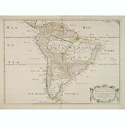
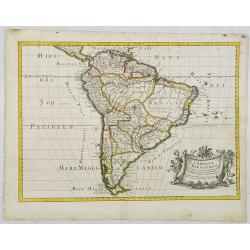
Amerique Meridionale. Par N.Sanson d'Abbeville. . .
The first edition of a cornerstone South America map, the first to show the boundaries of many countries, regions, and provinces. Peru is shown governing a huge tract of ...
- $500 / ≈ €437
Date: Paris, after 1650
Carte de L'AMERIQUE Corrigeé et argumenteé….
Separately published map published in 1658 but based on Petrus Bertius map of 1624., this on its turn taken from Jodocus Hondius map of 1618. On the sides he lists the pr...
Date: Paris, 1658
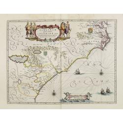
Virginiae Partis Australis, et Floridae Partis Orientalis.
Blaeu based this map on the Mercator-Hondius of 1606. A number of geographical improvements, however were incorporated, although two large fictions lakes accompanied by e...
Date: Amsterdam, 1658
Brasilia.
A mint example of this map is by Krystof Arciszewski, a Polish general who worked for the Dutch West Indian Company. The map perpetuates various myths including the Parim...
- $1250 / ≈ €1092
Date: Amsterdam, 1658
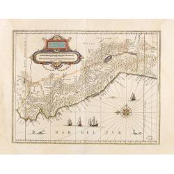
Peru.
Decorated with ships and monsters on the sea. Orientated with east at the top. Shows the Pacific coast of South America from Ecuador (at the left-hand side) as far south ...
- $400 / ≈ €349
Date: Amsterdam, 1658
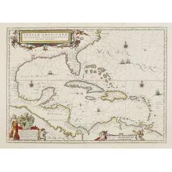
Insulae Americanae in Oceano Septentrionali cum Terris adiacentibus.
General map of the West Indies extending from Virginia to the mouth of the Orinoco, and destined to be copied in various shapes by many other publishers. Title cartouche ...
- $1500 / ≈ €1310
Date: Amsterdam, 1658
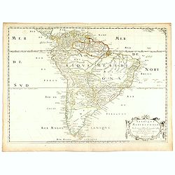
Amerique Meridionale. . . 1650.
First edition. A fine large map of South America, engraved by A.Peyrounin. The relatively unknown Amazon region is left without speculation. However, Sanson includes the ...
- $450 / ≈ €393
Date: Paris, 1650-1659

Paraquaria vulgo Paraguay cum adjacentibus.
Rare map only included in Joan Blaeu's Atlas major. Detailed map of Uruguay, Paraguay, Northern part of Argentina and northern part of Chili. Engraved by Gerard Coeck. Tw...
- $800 / ≈ €699
Date: Amsterdam, 1660
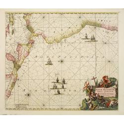
Nova Hispaniae, Chili, Peruviae, et Guatimalae Littorae..
A superbly decorative chart, oriented with north to the left of the sheet, covering the coasts of Central America, Peru, Chile, Jamaica and part of Cuba and Porto Rico. S...
- $1000 / ≈ €874
Date: Amsterdam, 1660

Nova Virginiae tabula.
A fine example of Blaeu's map of Virginia and the Chesapeake region is based on the first state of Smith's map, 1612, and is slightly larger and more expertly engraved.Th...
Date: Amsterdam, 1635/1660

Mappa Aestivarum Insularum alias Barmudas.
Blaeu based his work on John Speed's remarkably accurate map of 1626-1627. It shows the island divided into tribes and lots, and below the map itself appear the names of ...
Date: Amsterdam, 1662
![Noweav Mexiqve [California as an Island]](/uploads/cache/03796-250x250.jpg)
Noweav Mexiqve [California as an Island]
Uncommon miniature map of California as a island, from Pierre Duval's La Geographie Universeille in a second state. The map is derived from Audience de Guadalajara (1657)...
Date: Paris, 1663
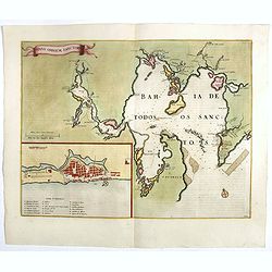
Sinus Omnium Sanctoru. Bahia de Todos os Sanctos.
RARE. First Atlas Major issue: originally issued by Blaeu in Casper van Baarle's 'Rerum per Octennium in Brasilia' (1647) dedicated to the former Governor of the Dutch co...
Date: Amsterdam, 1664
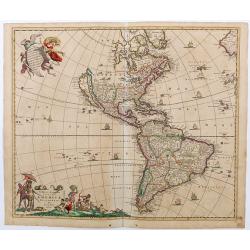
Nova Totius Americae descriptio.
First state of de Wit's first map of America, with figured borders on three sides. North America has a good overall outline, with a completed Hudson Bay and Baffin Island...
Date: Amsterdam, 1665

.Pascaerte Vande Zuyd-Zee tusschen California, en Ilhas de Ladrones. . .
A decorative and most interesting map - being one of the earliest of the Pacific to record the observations of Tasman's voyages. The northern part of the island of Califo...
Date: Amsterdam, 1666
Nouvelle description de lamerique.
Jollain published this rare map of America in 1667. State 3, with the scale, erased, as it fictitious strait on the west coast of North America which Le Royaume de Quiuer...
- $450 / ≈ €393
Date: Paris, 1667
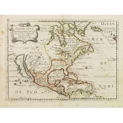
Americque Septentrionale. . .
A general map of North America shows California as an island, but with few names and a flat northern coastline. Prepared by N. Sanson and engraved by A.Peyrounin. A firs...
- $1000 / ≈ €874
Date: Paris, P. Marriete, 1667
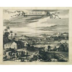
Serinhaim.
Fine view of a fort in Serinhaim, Brazil, with numbered key at the base. A procession of Portuguese or Dutch soldiers advance along the road carrying a litter. To the lef...
Date: London, 1671
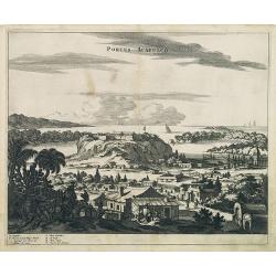
Portus Acapulco.
Attractive view of the city and harbor of Acapulco, showing fortifications, outlying buildings, ships in the harbor, costumed locals, etc.This map is taken from Ogilby's ...
- $300 / ≈ €262
Date: London, 1671
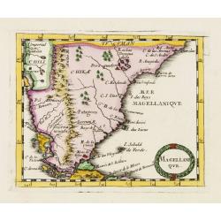
Magellani Que.
Uncommon miniature map of Argentina and Strait of Magellan from Pierre Duval's La Geographie Universeille dated 1676. Following his Cartes de geographie in 1657, Pierre D...
Date: Paris, 1676

Les Isles Terceres. . .
Uncommon map of the Azores. Engraved by Sommer. Du Val is mentioned as the cartographer and the publisher was Pierre Mariette.
Date: Paris, c. 1650 - 1676
Novissima et Accuratissima Totius Americae descriptio..
Third state of one of the classic Dutch maps of the Americas and one of the most often copied.Lower right hand corner F. de Wit excudit. Longitudinal lines numbered to th...
Date: Amsterdam, [1678
L'Amerique, en plusieurs cartes nouvelles, et exactes, &c. En divers traitez de geographie, et d'histoire. Là où sont descrits succinctement, & avec une belle Methode, & facile.
Third edition, the text and maps of which are identical to the first given in 1657. However, the dedication to Nicolas Fouquet (2 pp.), disgraced in 1661, has been delete...
- $4500 / ≈ €3931
Date: Paris, 1680

Pas-kaart vande Zee kusten van Venecuela met de Byleggende Eylanden. . .
Rare chart of the coast of Venezuela, including the islands of Curaçao, Bonaire, Aruba, etc.The chart has two insets, one (15x22cm) with a map of Curaçao, one smaller w...
Date: Amsterdam, 1680

Pascaerte van Carybes, Nieu Neder landt, Brazil. . .
This progenitor chart covers the American shores of the Atlantic Ocean. This chart by Theunis Jacobsz. was most probably engraved close to his death in 1650 or shortly af...
- $2200 / ≈ €1922
Date: Amsterdam, 1653-1681
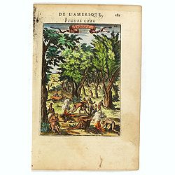
Hurons.
Attractive copper engraving, depicting Huron Indians or Wynadot / Wendat people hunting and gathering .From the French text edition of Description d'Univers, 1683. by All...
- $75 / ≈ €66
Date: Paris, 1683
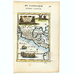
Mexique ou Nouvelle Espagne.
Attractive copper engraving, depicting Mexico with Central America.From the French text edition of Description d'Univers, 1683. by Allain Manneson Mallet (1630-1706), a w...
Date: Paris, 1683
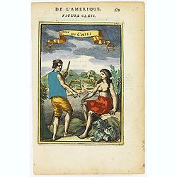
P.les du Chile.
A charming copper engraving depicting a town surrounded by a luxuriant landscape on the background and a couple of indigenous on the foreground.From the French text editi...
- $60 / ≈ €52
Date: Paris, 1683

Pas kaart Van Rio Oronoque Golfo De Paria met d'Eylanden Trinidad, Tabago, Granada, Granadillos, en Bequia . . .
A highly detailed and rare sea chart of the mouth of the Orinoco River, Trinidad, Tabago, St.Vincent and neighboring islands. Oriented with north to the right by two comp...
Date: Amsterdam, 1684
L'America Meridionale . . .
The second edition of Rossi's map of South America, based upon Sanson's map, but with revised Italian nomenclature. From his 'Mercurio Geografico...'. The engraver was G...
Date: Rome, 1687
Nova Virginiae Tabula
Uncommon state of one of the most important maps of the Chesapeake Bay region, credited with disseminating knowledge of the English settlement in Virginia throughout Euro...
Date: Amsterdam, ca. 1694
Two polar calottes from a globe.
Two polar calottes from 110 centimeters in diameter globe of 1688 including the northern part of Baffin Bay, Greenland, Iceland, Nova Zembla. Coronelli elected to follow ...
Date: Venice, 1696
Pas-Kaart Van de Golff de GUANAIOS Met 't Canaal tusschen YUCATAN en I. CUBA…
Very decorative sea chart of the Yucatan and Vicinity, including Cozumel, and parts of the Coast of Belize, Nicaragua, Honduras and the western part of Cuba, from De Nieu...
Date: Amsterdam, 1700
Insulae Americanae in Oceano Septentrionali..
A particularly handsome map portraying the south-eastern U.S., the Caribbean islands, part of Mexico, Central America, Florida (called tegesta Prov. ) and part of South A...
- $1500 / ≈ €1310
Date: Amsterdam, 1702
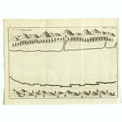
I. S. Sebastien.
Simplified bird's-eye view of Ilha de São Sebastiao, part of an archipelago off the southern coast of Brazil 210 miles from Rio de Janeiro. It was discovered on January ...
- $225 / ≈ €197
Date: Amsterdam, E. Roger, 1703
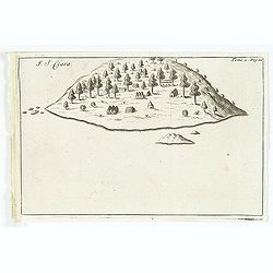
I. S. Clara.
Island "S. Clara" in Brazil just a few degrees north of the Tropic of Capricorn. From volume two of the French reissue of the account of early Dutch voyages. T...
- $150 / ≈ €131
Date: Amsterdam, E. Roger, 1703
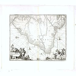
Brasilia.
Very fine decorative map od Brazil with west to the top. From the book "A Collection of Voyages and Travels" by Churchill and the map came from the part contain...
- $550 / ≈ €480
Date: London, Printed for A. and J. Churchill, 1703
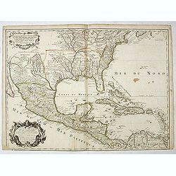
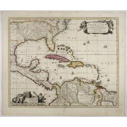
Carte du Mexique et de la Floride des Terres Angloises et des Isles Antilles...
The scarce third state with the imprint : "Chez l’Auteur sur le Quai de l’Horloge a la Cour.r de Diamãs. Avec Privilege du Roy po.r 20 ans, 1703". By 1707 ...
Date: Paris, 1703
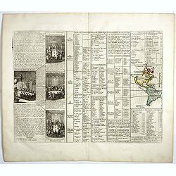
Carte du gouvernement de l'Amerique.
A double page sheet including a fine map of America, with California with indented northern coastline (130x92mm.) and New Mexico extending across most of western North Am...
- $300 / ≈ €262
Date: Amsterdam, 1705
