Browse Listings in America
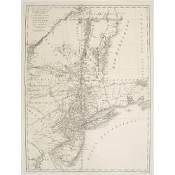
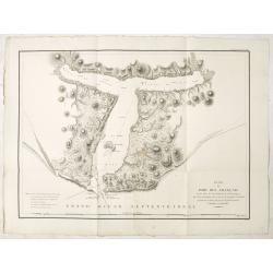
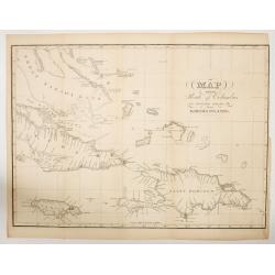
Carte des troubles De L'Amerique Levée par Ordre du Chevalier Tryon. . . New-York.. Jersey..
Revolutionary War mapA French edition of this uncommon Revolutionary War map describes the region from Salem, Massachusetts, to Buzzard's Bay, south to the Delaware River...
- $1500 / ≈ €1310
Date: Paris, 1778
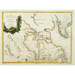
La Baja D'Hudson Terra di Labrador e Groenlandia.
Decorative map of Nova Scotia, Hudson Bay and part of Greenland. With many names of villages, as well engraved mountains and rivers are shown.Published in Zatta's "A...
- $300 / ≈ €262
Date: Venice, 1778
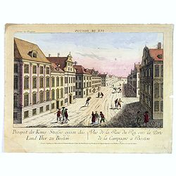
Vue de la Rue du Roi, vers la Porte de la Campagne a Boston.
A vue d'optique of the city of Boston. A view of a typical Bostonian street, with buildings opening directly onto the throughway, groups of people, gentlemen, workers and...
Date: Augsburg, 1778
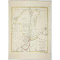
Mappa Geographica provinciae Nova.. NEW-YORK..
This map afforded British commanders during the Revolution an excellent overview of areas that would be crucial in the early years of the war, in particular the Hudson Va...
- $1500 / ≈ €1310
Date: Nuremburg, 1778
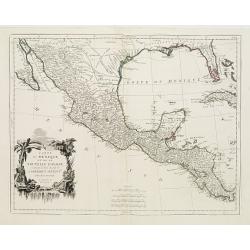
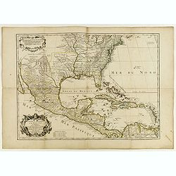
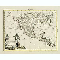
Carte du Mexique et de la Nouvelle Espagne..
Santini's version of D'Anville's important map shows the south-eastern part of the United States, Mexico and the Gulf of Mexico. Tecas is named as Nouv'le Leon. La Salle'...
Date: Venice 1779
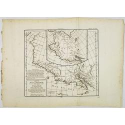
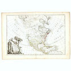
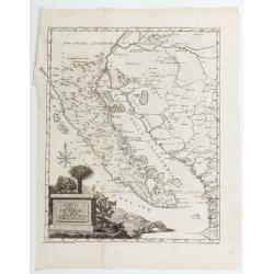
Carte de la Californie et des Pays Nord-Ouest. . . 4de Carte.
Diderot's famous 2 on 1 map shows the two early mappings of the west coast of North America, the first after Visscher, the second after Plancius' World map. Both show the...
- $200 / ≈ €175
Date: Paris, 1779
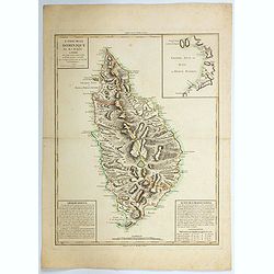
L'Isle de la Dominique par M.J.M.Anglois. . .
A handsome map of the Caribbean island of Dominica. There are "Observations" at lower left, and "Suite des observations" at lower right, both providin...
Date: Paris, 1779
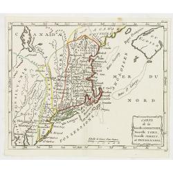
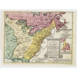
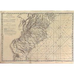
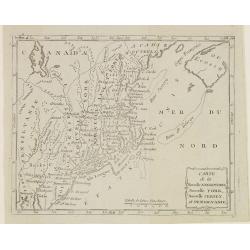
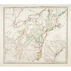
Carte de la Nouvelle Angleterre, Nouvelle York, Nouvelle Jersey, et Pensilvanie.
Highly detailed regional map of the Northeastern US, featuring numerous place names, Forts, Native American tribes, rivers,coastal banks, and other details. This is a Fre...
- $250 / ≈ €218
Date: Paris, 1780
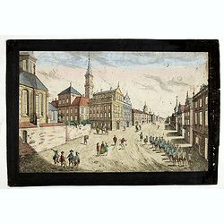
Prospect der Strasse gegen der Kirche der Recolecten in der obern Stadt zu Quebec. Vuë de la Rue des Recolets dans la haute Ville de Quebec.
A so-called optical print showing a decorative imaginary town view of Québec, with a street view with soldiers marching and pedestrians, an idealized view depicting Qué...
- $450 / ≈ €393
Date: Augsburg, ca. 1780
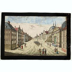
Prospect des Haupt Plazes der Untern Stadt zu Quebec.
A so-called optical print showing a decorative imaginary town view of Québec, with a street view with soldiers marching and pedestrians, an idealized view depicting Qué...
- $500 / ≈ €437
Date: Augsburg, ca.1780
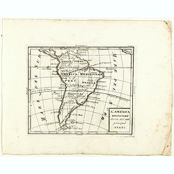
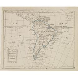
L'America meridionale divisa nei suoi principali stati.
Rare map of south America, from "Atlante Novissimo ad uso Dei Giovani Studiosi Contenuto In Carte XXVII.", published by Giovanni Zempel in Rome, ca. 1780.The ma...
- $100 / ≈ €87
Date: Rome, 1780
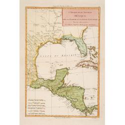
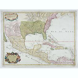
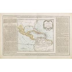
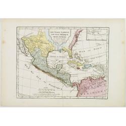
L'Ancien et le nouveau Mexique avec la Floride..
Covering Florida, Texas, western part of Cuba and central America. Showing dozens (100+) of place names, extensive river systems, mountain ranges and featuring the Gulf o...
Date: Paris, 1781
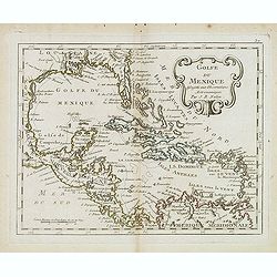
Golfe du Mexique Assujetti aux Observations Astronomiques Par J.B.Nolin.
Rare map of the Caribbean prepared by J.B.Nolin and published by L.J. Mondhare for his Atlas Général a l'usage des colleges et maisons d'education.. Louis Joseph Mondha...
- $200 / ≈ €175
Date: Paris, 1781
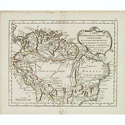
Carte du Bresil le Perou. . .
Scarce map of Northern part of South America with Venezuela, Colombia, Brazil and Peru, prepared by Nolin and published by L.J. Mondhare for his Atlas Général a l'usage...
- $125 / ≈ €109
Date: Paris, 1781
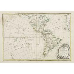
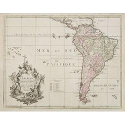
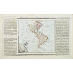
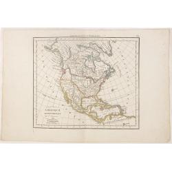
L'Amerique Septentrionale Divisee en Ses Principaux Etats. . .
Engraved by Lattré. This map is most notable for its depiction of Mer de L'Quest or Sea of the West, near modern-day Seattle. A great sea, easily the size of the Mediter...
- $400 / ≈ €349
Date: Paris, 1782
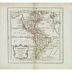
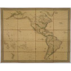
L' Amerique divisée par Grands Etats. . .
Attractive map of America, ornated with a decorative title cartouche. Boundaries outlined in hand color.Prepared by Le Sieur Janvier, Jean denis [Robert], French geograph...
- $450 / ≈ €393
Date: Paris, ca 1783
L'Amérique suivant les dernier. . .
Scarce map of America, prepared by Nolin and published by L.J. Mondhare for his Atlas Général a l'usage des colleges et maisons d'education.. Louis Joseph Mondhare was ...
- $200 / ≈ €175
Date: Paris, 1783
Carte du Mexique et des Etats Unis d'Amérique...
A later edition of De l'Isle's foundation map of 1703 is widely regarded as one of the most influential maps in the history of American Cartography. This updated version ...
Date: Paris, 1783
Carte du Mexique et des Etats Unis d'Amérique…
A later edition of De l'Isle's foundation map of 1703, widely regarded as one of the most influential maps in the history of American Cartography. This updated version o...
Date: Paris, 1783

Carte Générale du Canada, de la Louisiane, de la Floride, de la Caroline..
Map of the eastern part of the United States and Canada. With inset map of Hudson and Baffin bays. in the lower right corner.Venetian edition of d'Anville's map, from &qu...
Date: Venice, 1776 - 1784
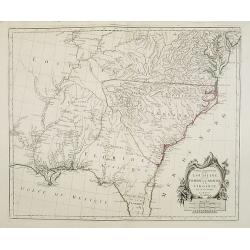
Partie Méridionale de la Louisiane, avec la Floride, la Caroline et la Virginie..
Fine map of southeastern part of the United States after d'Anville's, to whom Santini gives credit in the cartouche.It covers the Atlantic coastline between the Chesapeak...
Date: Venice, 1776 - 1784
Messico ouvero Nuova Spagna che contiene Il Nuova Messico La California con una Parte de Paesi Adjacenti. . .
Decorative and detailed map of Mexico, Texas, Florida, Louisiana, and Central America. The map is filled with remarkable detail throughout, particularly in Texas, New Mex...
Date: Venise, 1785

Amérique Septentrionale .. Les Etats Unis..
Very rare state: probably separately issued. Published the same year as the Treaty of Paris, this is one of the first maps to show printed boundary lines for the newly...
- $3000 / ≈ €2621
Date: Paris, 1786
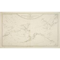
Karte von den N.W. Amerikanischen und N.OE. Asiatischen Kusten nach den Untersuchungen des Kapit. Cook...
A detailed large-scale map showing the Bering Strait, Kamchatka, Alaska and much of North America. While the Russian coastline is shown with reasonable accuracy. Showin...
- $450 / ≈ €393
Date: Vienna, 1788

L'Amérique divisée en ses principaux Etats Dressée d'après les Cartes de Mr. Bonne. . .
Rare, wall map of America in 2 sheets, after R. Bonne. With 3 inset maps of Hispaniola, Martinique and Hudson Bay. Beautiful title cartouche depicting a Native American l...
Date: Paris, 1788
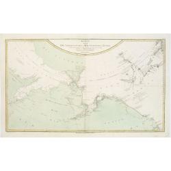
Karte von den N.W. Amerikanische und N.O.E. Asia. . .
German edition of Cook's explorations along the NW Coast of America and NE Coast of Asia, based upon the original work by Lieutenant Henry Roberts.A detailed large-scale ...
- $400 / ≈ €349
Date: Vienna, 1788
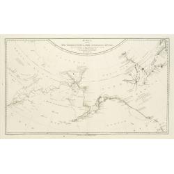
Karte von den N.W.Amerikanische und N.O.E. Asia..
A detailed large-scale map showing the Bering strait, Kamchatka, Alaska, and much of North America. While the Russian coastline is shown with reasonable accuracy. Showing...
Date: Vienna 1788
Carta Della California Suo Golfo E. Contracoste della Nueva Spagna.
Map featuring the California Peninsula and New Spain by Francisco Saverio Clavigero, engraved by J. Zambelly. Title cartouche within a landscape of cacti and palm trees.O...
Date: Venice, 1788
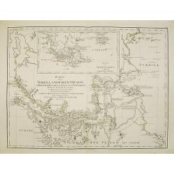
Karte der Magellanischen-Strasse. . .
Very detailed map of Strait of Magellan, with in top inset map of Southern tip of South America with the Falklands. Prepared by Don Juan de La Cruz of Spain.Engraved by J...
- $600 / ≈ €524
Date: Vienna, 1789
Guayane, Terre Ferme Isles Antilles. . .
Map showing Mexico, Cuba, Central America. Left and right a box with geographical information for each part country on the continent.Prepared by Louis Brion de la Tour an...
- $200 / ≈ €175
Date: Paris, 1790
![[North America]](/uploads/cache/25907-250x250.jpg)
[North America]
Uncommon map of North America. The young United States incorporates the upper Midwest, with the remaining western territories of Louisiana, Nouveau Mexique, Nouveau Albio...
Date: Augsburg, ca. 1790
L'Amerique selon l'Etendue de Ses Principales Parties et don't les Points Principaux. . .
Uncommon map of South America, decorated with an elaborate cartouche referring to the conversion of the natives to Christianity, with natives bowing to a figure holding a...
Date: Augsburg, ca. 1790

Uomo del Canale di Noël della terra del Fuoco, nel Mar Australe. / Homme du Canal de Noël de la terre de Feu dans la Mer Australe.
Full portrait of a man from Christmas Sound, in Tierra del Fuego This engraved print on laid paper is from "Raccolta di stampe," a series of historically sign...
Date: Venice, Antonio Zatta, c.1790
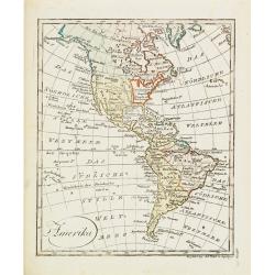
L' Amerique dressée pour l'étude de la géographie . . .
Map showing the American continent. California with a large inlet. Some major cities, bodies of water, and geographic features are marked. There are illustrations of ship...
- $200 / ≈ €175
Date: Paris, 1790
Die Vereinigten Staaten von Nord Amerika..
Uncommon map of the east coast of North America, including the Great Lakes area. To the right inset map of New Foundland. After the map by William Faden of 1783. With col...
- $500 / ≈ €437
Date: Germany, 1790
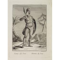
Uomo del Perù. / Homme du Perou.
Full portrait of a Peruvian warrior. From “Raccolta di … stampe.” a series of historically significant eighteenth-century copper plate engravings by Venetian engrav...
Date: Venice, Antonio Zatta, c.1790
De vereenigde staten van Noord America.
Rare miniature map of Eastern United States. The map carries the signatures of W.Holtrop and the engraver H.Klokhoff. Steven van Esveldt's business was carried on by his ...
Date: Amsterdam, 1791
![Mappa Mondo tagliato sulpiano di unmeridiano Emisfero Occidentale. [togther with] … Orientale.](/uploads/cache/48543-250x250.jpg)
Mappa Mondo tagliato sulpiano di unmeridiano Emisfero Occidentale. [togther with] … Orientale.
World map on two sheets - Western Hemisphere (North and South America, Oceania, Greenland) and Eastern Hemisphere (Europe, Africa, Asia, Australia). Published by Pazzini,...
- $500 / ≈ €437
Date: Siena, 1796
Plan du Port des Francais sur la Cote du Nord-Ouest de l'Amerique, par 58°37' de Latitude Nord et 139°50' de Longitude Occidentale, Decouverte le 2 Juillet 1786, par les Fregates Francaise la Boussole et l'Astrolabe.
Chart of the entrance of Bassin de L'Quest , visited on July 2nd 1786 by La Perouse. On many 18th century maps we find a depiction of Mer de L'Quest or Sea of the West a ...
- $500 / ≈ €437
Date: Paris, 1798
Carte Réduite des Côtes Orientales Del'Amérique Septentrionale Contenant partie du Nouveau Jersey, la Pen-sylvanie, le Mary-land, la Virginie, la Caroline Septentrionale, la Caroline Méridionale et la Georgie. . .
Scarce Rome edition of an French map made expressly for use of the French Navy during the American Revolution. Covering the area of Maryland, North and South Virginia. Ph...
- $900 / ≈ €786
Date: Genova, Yves Gravier, c.1800
![[Lot of 5 maps] Kaart van de noord-west kust van Amerika en de noord-oost kust van Asia.](/uploads/cache/19136-250x250.jpg)
[Lot of 5 maps] Kaart van de noord-west kust van Amerika en de noord-oost kust van Asia.
- Kaart van de noord-west kust van Amerika en de noord-oost kust van Asia. Opgenoomen in de Jaaren 1778 en 1779. Captain James Cook (1728-79), explorer, circumnavigato...
Date: Leiden, 1795-1803
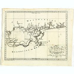
Charte von der mündung des Mississippi. Weimar, Verlage des Landes Indust. Compt. 1803.
Scarce map showing the mouth of the Mississippi into the Gulf of Mexico. With Pensacola in Western Florida, Mobile Bay in Alabama and Louisiana with New Orleans and their...
- $300 / ≈ €262
Date: Weimar, 1803
Nouvelle Espagne, Nouveau Méxique, Isles Antilles, par Robert de Vaugondy corrigés par le Cen. Lamarche Géog. Successeur de Vaugondy. l''An 3e.
Although dated 1794/95 [l'An 3e.], the map is a copy of an earlier map which appeared in Robert de Vaugondy's 1778 atlas. Hence, it does not show the newly independent Un...
- $300 / ≈ €262
Date: Paris, 1794 - 1806

Homme & Femme Ottawas.
Hand-colored mezzotint of Native Americans engraved by Félix Mixelle and Lachaussée Jeune after Jacques Grasset de Saint-Sauveur.As an etcher, drawer and writer, Grasse...
- $75 / ≈ €66
Date: Paris,1801-1806
L'Amérique Méridionale, Divisée en ses Principaux Etats.
Map of South America, from Atlas de la Géographie de toutes les parties du monde .. Ouvrage destiné pour l'education, et nécessaire aux négocians, aux voyageurs, aux ...
Date: Paris, Prudhomme, Levrault, Debray, 1806
Carte de la Nouvelle Angleterre, Nouvelle York, Nouvelle Jersey, et Pensilvanie.
Map of the north eastern part of the United States, from Atlas de la Géographie de toutes les parties du monde .. Ouvrage destiné pour l'education, et nécessaire aux n...
Date: Paris, Prudhomme, Levrault, Debray, 1806
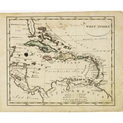
West indien.
Nice small map of The West Indies, with Cuba, Jamaica, S.Domingo, etc. Southern tip of Florida is included. Map by Johannes Walch in his rare Allgemeiner Atlas Nach den b...
Date: Augsburg, 1812
Amerique ou Indes Occidentales..
Fine map of the Western Hemisphere with on right hand side geographical index tables with also mentioning the Spanish, English, French, Danish possessions. Prepared by Ro...
Date: Paris, 1812
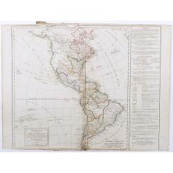
Amérique, réduite d'après celles d'Arrowsmith en 4 flles Par J.N.Champion, Ingénieur-Geographe et . . . Nouvelles découvertes de Clacke et du Major Pike . . .
A charming folding-map of America, drawn by J.N. Champion. The title explains that the map used the latest information by Alexander Humboldt and Clarck and Pike. Dated 18...
- $500 / ≈ €437
Date: Paris, 1815
Carte d' Amérique Septentrionale 1817.
Map of North and Central America. Engraved by E.Collin, active at 23, quai des Augustins, Paris.
- $300 / ≈ €262
Date: Paris, 1817
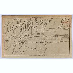
Little Egg Harbour.
A small sea chart showing Little Egg Harbour east of Tucker's Island. This map was published in the “American Coast Pilot”, a detailed guide to harbors, capes and hea...
- $50 / ≈ €44
Date: New York, 1817
Gedeelte van den Vereenigden Staat van Noord Amerika.
A rare an detailed map of the eastern part of the United States of America. After Isaac Weld's map from his Travels through the States of North America 1799. Barbara Back...
- $650 / ≈ €568
Date: Netherlands c. 1820
MAP OF THE Route of Columbus on arriving among the Bahama Islands.
An impressive detailed chart of the Bahama Bank, plus surrounding smaller islands, plus most of Cuba, Jamaica, Saint Domingo (Dominican Rep & Hayti). The map has grid...
Date: New York, ca.1820
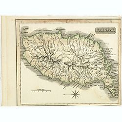
Grenada.
A delightfully detailed map the West Indian island Grenada by John Thomson. The map displays excellent detail concerning roads, rivers, towns, bays, harbours and other in...
- $50 / ≈ €44
Date: Edenburgh, 1821
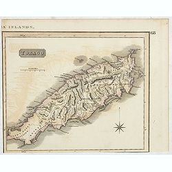
Tobago.
A delightfully detailed map of the West Indian island Tobago by John Thomson. The map displays excellent detail concerning roads, rivers, towns, bays, harbors, and other ...
- $50 / ≈ €44
Date: Edenburgh, 1821
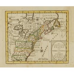
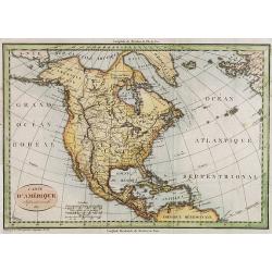
L'America septentrionale.
Charming and finely engraved map of North America from the rare atlas Atlante Tascabile o sia Serie di Num. XXI Cartine Geografiche nelle quali si rappresenta in ristrett...
- $275 / ≈ €240
Date: Rome, 1823
Amérique septentrionale.
A fine map of North America published by the well-known Paris publisher of maps, globes and atlases C.F. Delamarche.
- $110 / ≈ €96
Date: Paris, 1824
Amerika
Scarce miniature map of the Western Hemisphere.
- $200 / ≈ €175
Date: Augsburg, 1824
![Carte Géographique [ . . .] de la Pensylvanie.](/uploads/cache/14221-250x250.jpg)
Carte Géographique [ . . .] de la Pensylvanie.
Detailed map of Pennsylvania. From J.A. Buchon, Atlas Gégraphique Statistique, historique et chronologique des deux Amériques et des isles adjacentes. traduit de l'atla...
- $250 / ≈ €218
Date: Paris, 1825
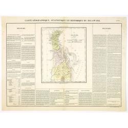
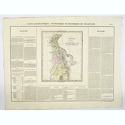
Carte Géographique .. Delaware.
Detailed map of Delaware. From J.A. Buchon, Atlas Gégraphique Statistique, historique et chronologique des deux Ameriques et des isles adjacentes, traduit de l'atlas ex�...
- $300 / ≈ €262
Date: Paris, 1825
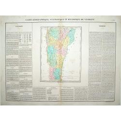
Carte Géographique .. Vermont.
Detailed map of Vermont. From J.A. Buchon, Atlas Gégraphique Statistique, historique et chronologique des deux Amériques et des isles adjacentes: traduit de l'atlas ex�...
- $250 / ≈ €218
Date: Paris, 1825
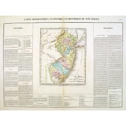
Carte Géographique .. New Jersey.
Detailed map of New Jersey. From J.A. Buchon, Atlas Gégraphique Statistique, historique et chronologique des deux Amériques et des isles adjacentes: traduit de l'atlas ...
- $300 / ≈ €262
Date: Paris, 1825
Carte de l'Amerique septentrionale Rédigée par A.H.Brué géographe.
Detailed dissected folding-map of North and Central America by Brué, originally published in Atlas Universel but here mounted on linen and intersected in 8 parts. Next t...
- $250 / ≈ €218
Date: Paris, 1825
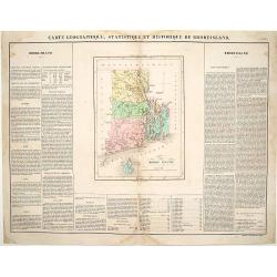
Carte Géographique, statistique et historique du Rhode Island.
Detailed map of Rhode Island. From J.A. Buchon, Atlas Gégraphique Statistique, historique et chronologique des deux Amériques et des isles adjacentes, traduit de l'atla...
- $175 / ≈ €153
Date: Paris, 1825
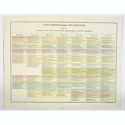
Carte Chronologiquedes Etats-Unis.
A hand colored historical timeline table (in French), highlighting "the main [historical] events in the years from their establishment to the declaration of independ...
- $100 / ≈ €87
Date: Paris, 1825
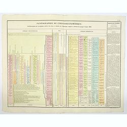
Pantographie de l'Histoire d'Amerique, ou Description de la situation relative des etats et colonies de l'Amerique. . .
An attractivelooking hand colored historical timeline table (in French), charting important historical events and discoveries of America and their States and Colonies sin...
- $100 / ≈ €87
Date: Paris, 1825
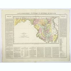
Carte Geographique, Statistique ey Historique du Maryland.
A lovely, detailed map of Maryland, from Buchon's, Atlas Gégraphique Statistique, historique et chronologique des deux Ameriques et des isles adjacentes, traduit de l'at...
- $100 / ≈ €87
Date: Paris, 1825
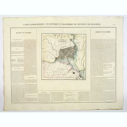
Carte Geographique, Statistique ey Historique du District de Colombie.
A lovely, detailed map of the District of Columbia, (Washington) from Buchon's, Atlas Gégraphique Statistique, historique et chronologique des deux Ameriques et des isle...
- $100 / ≈ €87
Date: Paris, 1825
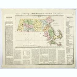
Carte Geographique, Statistique et Historique de Massachusetts.
A detailed map of Massachusetts, from Buchon's Atlas Gégraphique Statistique, historique et chronologique des deux Ameriques et des isles adjacentes, traduit de l'atlas ...
- $100 / ≈ €87
Date: Paris, 1825
Carte Geographique, Statistique et Historique du Delaware.
A nice detailed map of Delaware, from Buchon's Atlas Gégraphique Statistique, historique et chronologique des deux Ameriques et des isles adjacentes, traduit de l'atlas ...
- $100 / ≈ €87
Date: Paris, 1825
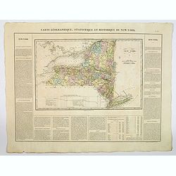
Carte Geographique, Statistique et Historique du New York.
A detailed map of State of New York, from Buchon's Atlas Gégraphique Statistique, historique et chronologique des deux Ameriques et des isles adjacentes, traduit de l'at...
- $100 / ≈ €87
Date: Paris, 1825
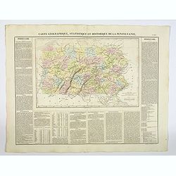
Carte Géographique, Statistique et Historique de la Pensylvanie.
A detailed map of Pennsylvania, from Buchon's Atlas Gégraphique Statistique, historique et chronologique des deux Amériques et des isles adjacentes, traduit de l'atlas ...
- $100 / ≈ €87
Date: Paris, 1825
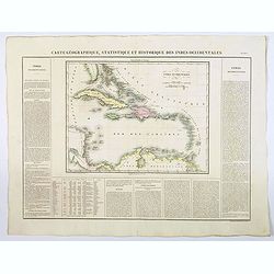
Carte Geographique, Statistique et Historique des Indes Occidentales.
A nice detailed map of The West Indies, including Cuba, the Bahamas, the southern most tip of FL, parts of Central America, and the northern tip of South America. From Bu...
Date: Paris, 1825
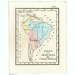
Prvinces des Jésuites dans l'Amerique méridionale.
Rare map of South America from "Atlas Universel indiquant les établissemens des Jésuites: avec la manière dont ils divisent la terre, suivi desévénemens remarqu...
- $200 / ≈ €175
Date: Paris, Ambroise Dupont , 1826

Danse d'indiens.
From Giulio Ferrario's work Le Costume ancien et moderne ou histoire du gouvernement, de la milice, de la religion, des arts, etc. published in Milan by the author betwee...
- $50 / ≈ €44
Date: Milan, 1827
Les Aleuts.
From Giulio Ferrario's work Le Costume ancien et moderne ou histoire du gouvernement, de la milice, de la religion, des arts, etc. published in Milan by the author betwee...
- $50 / ≈ €44
Date: Milan, 1827
![[The Callo Palace ].](/uploads/cache/27288-250x250.jpg)
[The Callo Palace ].
Aquatint depicting Peruvian Inca Palace called Callo.Engraved by Fumagalli.From Giulio Ferrario's work Le Costume Ancien et Moderne ou Histoire du gouvernement, de la mil...
- $80 / ≈ €70
Date: Milan, 1827
![[The Callo Palace.]](/uploads/cache/27289-250x250.jpg)
[The Callo Palace.]
Aquatint depicting upper portion of print an Inca Palace near Cannar in the province of Quito in Peru. Bottom portion a plan of the palace (70 x 160).Engraved by Fumagall...
- $80 / ≈ €70
Date: Milan, 1827
![[Spanish Sheppard's in Paraguay ].](/uploads/cache/27290-250x250.jpg)
[Spanish Sheppard's in Paraguay ].
Aquatint depicting Spanish Sheppard's in Paraguay.Engraved by Gallina.From Giulio Ferrario's work Le Costume Ancien et Moderne ou Histoire du gouvernement, de la milice, ...
- $50 / ≈ €44
Date: Milan, 1827
![[ The circular fortress of Cannar, Peru. ]](/uploads/cache/27292-250x250.jpg)
[ The circular fortress of Cannar, Peru. ]
Aquatint depicting the circular fortress of Cannar, Peru.Engraved by Fumagalli.From Giulio Ferrario's work Le Costume Ancien et Moderne ou Histoire du gouvernement, de la...
- $80 / ≈ €70
Date: Milan, 1827
