Browse Listings in America > America250

Inventio Maris Magallanici.
Allegorical scene, allegorical image celebrating the circumnavigation of the earth by Ferdinand Magellan. The image shows Magellan aboard his ship, surrounded by mytholog...
- $750 / ≈ €655
Date: Frankfurt, 1594
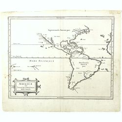
Americae sive Indiae Occidentalis.
Hessel Gerritsz., the author and probable engraver of the map had seen maps of California as an island, but he relies on the more trustworthy accounts, such as Herrera, i...
- $1000 / ≈ €874
Date: Leiden, 1625
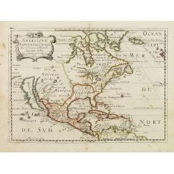
Americque Septentrionale. . .
A general map of North America shows California as an island, but with few names and a flat northern coastline. Prepared by N. Sanson and engraved by A.Peyrounin. A firs...
- $1000 / ≈ €874
Date: Paris, P. Marriete, 1667
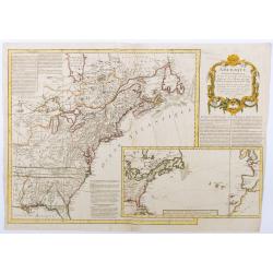
Amérique septentrionale, suivant les Nouvelles Découvertes…
Full title: Amérique septentrionale, suivant les nouvelles découvertes, augmenté des collonies qui sont derrière la Virginie et cour de l'Ohio. Translated from the En...
Date: Paris, 1757
![[Set of five maps] Carte Generale de la Terre ou Mappe Monde avec les Quatres Principaux Sistemes . . . 1776 (with) Carte D'Amerique ... (and) Carte D'Afrique . . . (and) Carte d'Asie) (and) Carte D'Europe . . . 1776](/uploads/cache/41145X-250x250.jpg)
[Set of five maps] Carte Generale de la Terre ou Mappe Monde avec les Quatres Principaux Sistemes . . . 1776 (with) Carte D'Amerique ... (and) Carte D'Afrique . . . (and) Carte d'Asie) (and) Carte D'Europe . . . 1776
Rare and decorative set of five wall maps of the world and the four continents, prepared by Clouet, in very fine, bright contemporary coloring. Each map ca. 965 x 1230 mm...
Date: Paris and Cadiz, Mondhare, 1776
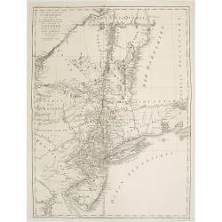
Carte des troubles De L'Amerique Levée par Ordre du Chevalier Tryon. . . New-York.. Jersey..
Revolutionary War mapA French edition of this uncommon Revolutionary War map describes the region from Salem, Massachusetts, to Buzzard's Bay, south to the Delaware River...
- $1500 / ≈ €1310
Date: Paris, 1778
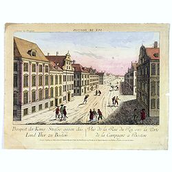
Vue de la Rue du Roi, vers la Porte de la Campagne a Boston.
A vue d'optique of the city of Boston. A view of a typical Bostonian street, with buildings opening directly onto the throughway, groups of people, gentlemen, workers and...
Date: Augsburg, 1778

Amérique Septentrionale .. Les Etats Unis..
Very rare state: probably separately issued. Published the same year as the Treaty of Paris, this is one of the first maps to show printed boundary lines for the newly...
- $3000 / ≈ €2621
Date: Paris, 1786

L'Amérique divisée en ses principaux Etats Dressée d'après les Cartes de Mr. Bonne. . .
Rare, wall map of America in 2 sheets, after R. Bonne. With 3 inset maps of Hispaniola, Martinique and Hudson Bay. Beautiful title cartouche depicting a Native American l...
Date: Paris, 1788
