Browse Listings
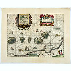
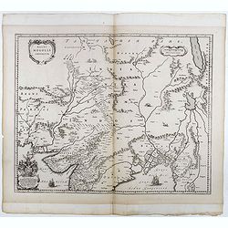
Moluccae Insulae Celeberrimae.
Showing the geographical features of the islands and decorated with ships, sea monsters and a handsome cartouche. With an inset of Bachian island. From early on Willem J...
- $750 / ≈ €641
Date: Amsterdam, ca.1645
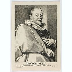
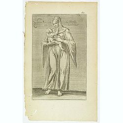
Theodorus Galle, Calcographus Anterpiæ.
Portrait of Theodorus Galle engraved by Lucas Vorsterman. Lucas Vorsterman was a Baroque engraver. He worked with the artists Peter Paul Rubens and Anthony van Dyck, as w...
Date: Antwerp, ca. 1645
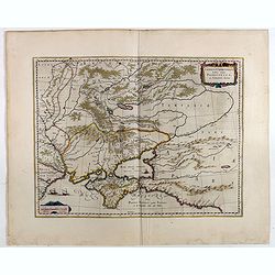
Taurica Chersonesus, Nostra aetate Prezecopsca, et Gazara dicitur.
Part of Russia with in the north Smolensk and including Moscow and in the south the Black Sea.More about Willem Blaeu. [+]Taurica, Tauric Chersonese, and Taurida were nam...
- $500 / ≈ €427
Date: Amsterdam, 1645
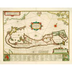
Mappa Aestivarum Insularum, alias Barmudas. . .
It shows the island divided into tribes and lots, and below the map itself appear the coats of arms of Bermuda and England and the names of the first proprietors and the ...
Date: Amsterdam, 1645
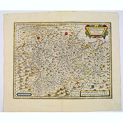
Westphalia Ducatus.
Originally engraved for Jodocus Hondius II, at his death in August 1629, this map was, among 39 other copper plates, purchased by Willem Blaeu who deleted Hondius' name a...
Date: Amsterdam, 1645
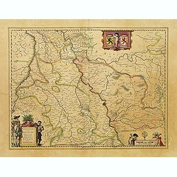
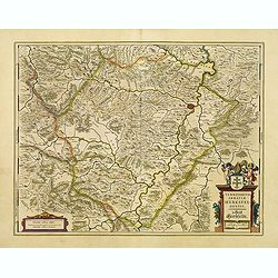
Juliacensis et Montensis Ducatus / De Hertoghdomen Gulick en Berghe.
Detailed map centered on Cologne. Embellished with scale cartouche with cherubs, a cartouche with a putti inside holding two coats of arms. Lower left corner, the title c...
- $150 / ≈ €128
Date: Amsterdam, 1645
![Perchensis Comitatus [together with] Comitatus Blesensis.](/uploads/cache/44784-250x250.jpg)
Perchensis Comitatus [together with] Comitatus Blesensis.
Two maps on one sheet, each with its own decorative title cartouche. These maps detail the region of the Loire River. Perchensis includes the cities of Mortagne, Nogent-l...
Date: Amsterdam , ca 1645
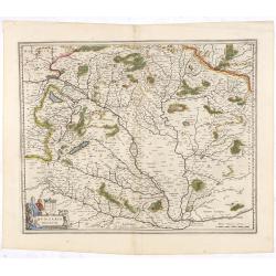
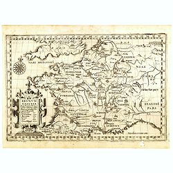
Hungaria Regnum.
Detailed map of Hungary centered on Budapest. Including the towns of Vienna, Zagreb as well.As Willem Blaeu died in 1638 most of his maps are actually published by his so...
Date: Amsterdam, 1645

Carta particolare che comincia con il c.apo Aldea è Finisce con il capo Degortam. . .
Dudley’s magnificent chart shows the south west coast of Africa with the Tropic of Capricorn, located at about 23.5 degrees south. Without the privilege, but with "...
Date: Florence, 1645
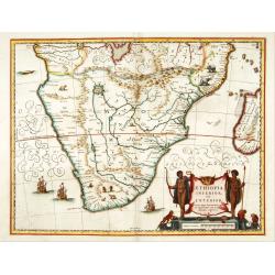
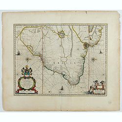
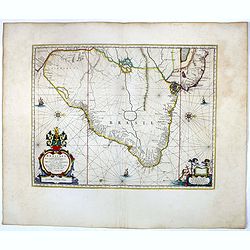
Aethiopia inferior, vel exterior.
The standard map of South Africa throughout the 17th century. The lake out of which the 'Zambere' -the Zambesi- flows is probably based on reports of Lake Ngami, undiscov...
- $575 / ≈ €491
Date: Amsterdam, 1645
Tartariae sive Magni Chami Imperium.
Fine map of Tartary, including northern part of China, and tip of Korea.
- $500 / ≈ €427
Date: Amsterdam, 1645
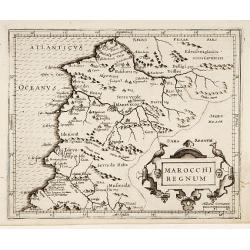
Marocchi Regnum.
From the Mercator/Hondius Atlas Minor. Early map of Morocco.
Date: Amsterdam, 1645
![[Map of the coast of Crete to the east of Chania showing the landing of the Turks and the Venetian defence in June 1645].](/uploads/cache/49076-250x250.jpg)
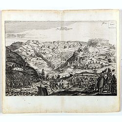
[Map of the coast of Crete to the east of Chania showing the landing of the Turks and the Venetian defence in June 1645].
Map engraved by Marco Boschini (1613-1678). With a lettered key for the Turkish army « A-L » and a numbered key for the city of Chania and its army « 1-20 ».Fifth ...
Date: Venice, c. 1645
![Ins. de Cerno a. Nostatibus Mauritius Nominata [on sheet with] Gunnanappi Labetacq [and] Civitas Gammelamme [and] Rex Tubatus.](/uploads/cache/48504-250x250.jpg)
Ins. de Cerno a. Nostatibus Mauritius Nominata [on sheet with] Gunnanappi Labetacq [and] Civitas Gammelamme [and] Rex Tubatus.
Three views and one map on one page: Shows natives on Mauritius fishing and building a boat, with a dodo and two turtles at right; The Banda islands; A procession for th...
Date: Amsterdam, c.1646

Franconiae nova descriptio.
Second state of this early map of Franken, including Regensburg, Heidelberg, Marburg and Hof. In lower part decorative cartouches and upper right a dedication to Franz vo...
Date: Amsterdam, after 1646
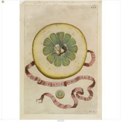
Eadem Aurantia Dimidiata.
Decorative engraving representing a citrus fruit. Taken from the book "Hesperides sive de malorum aureorum" by Giovan Battista Ferrari (Italian botanist, 1584-1...
Date: Rome, Scheus, 1646
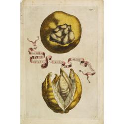
Aliae Formae Citrati Limonis Alios Includentis.
Decorative engraving representing a citrus fruit. Taken from the book "Hesperides sive de malorum aureorum" by Giovan Battista Ferrari (Italian botanist, 1584-1...
Date: Rome, Scheus, 1646
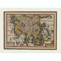
Asia.
This lovely rare miniature map of the continent of Asia is a single page with text on verso taken from John Speed's folio atlas, and is signed with Van den Keere's Latini...
- $275 / ≈ €235
Date: London, 1646

Carta terza Generale del' Asia.
Rare first state of this important chart showing part of the north coast of New Guinea and islands of the Pacific Ocean. To the north of Japan the landmass of Isola di Ie...
Date: Florence, 1646
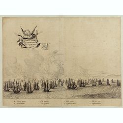
Quartum Praelium Coniovian inter et Fluvium Rio Grande XVII Ian
Decorative engraving of the fourth sea battle with the Portuguese fleet offshore at the Rio Grande, in1640. Engraved by J. van Brosterhuyzen after a design by Frans J. Po...
Date: Joannes Blaeu, Amsterdam 1647
Brasilia.
Fine copy of this map by Krystof Arciszewski, a Polish general who worked for the Dutch West Indian Company. The map perpetuates various myths including the Parime Lago ,...
Date: Amsterdam, 1647
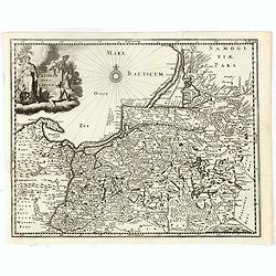
Prussiae nova tabula.
Rare map of Prussia with nowadays Poland. The map features a bold title cartouche, a ship, compass rose, and a sea monster in the Baltic Sea. The map was prepared by the ...
- $550 / ≈ €470
Date: Amsterdam, 1647

Insulae Americanae in Oceanus Septentrionali cum Terris..
General map of the West Indies extending from Virginia to the mouth of the Orinoco, and destined to be copied in various shapes by many other publishers. Title cartouche ...
Date: Amsterdam, 1647
![[Two volumes, with two Leo maps] De Bello Belgico, Decas Prima / Decas Secunda.](/uploads/cache/48779-250x250.jpg)
[Two volumes, with two Leo maps] De Bello Belgico, Decas Prima / Decas Secunda.
With 2 engraved titles of the 'Leo Belgicus', with one paw resting on a shield bearing the title, large woodcut printer's device on the colophons, and 30 richly engraved ...
Date: Rome, Franciscus Corbelletus, 1632-1647
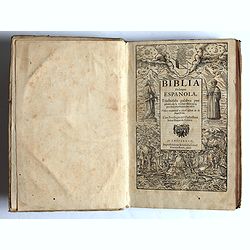
Traduzida palabra por palabra de la verdad Hebrayca, por muy excelentes letrados.
Complete title : Traduzida palabra por palabra de la verdad Hebrayca, por muy excelentes letrados. Vista y examinad a per el officio de la Inquisicion. Con Privilegio del...
- $8500 / ≈ €7263
Date: Ampsterdam, Gillis Ioost, 1647
![De Bello Belgico, Decas PrimaDeces II. [with 2 Leo Belgicus maps]](/uploads/cache/21542-250x250.jpg)
De Bello Belgico, Decas PrimaDeces II. [with 2 Leo Belgicus maps]
Each volume contains an engraved title with a representation of the Netherlands and Belgium in the shape of a lion, with one paw resting on a shield bearing the title, a ...
Date: Rome, Franciscus Corbelletus, 1632-1647
Hollandia Comitatus.
Orientated west to the top of the sheet, this presents the County of Holland in the classical orientation for seventeenth century maps, with Amsterdam at the center. The ...
Date: Amsterdam, 1647

Asia carta di ciasete piu moderna. (Japan)
Rare FIRST STATE of this important map for Korea and Japan, a map of the Blancus/Moreira type, but adds a huge 'Jesso' filling the top of this old map. The map is of inte...
Date: Florence, 1646-1647

Tabula Bergarum ad Zomam Stenbergae et novorum ibi operum.
The map gives an outline of the Scheldt from Bergen op Zoom to Antwerp, with all the ramparts built between 1622 and 1627.
Date: Amsterdam, 1647
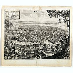
Isfahan.
An early of Isfahan in central Iran,. From the rare first edition "Offt begehrte Beschreibung der newen orientalischen Rejse, so durch Gelegenheit einer Holsteinisc...
- $250 / ≈ €214
Date: Schleßwig, Zur Glocken, 1647
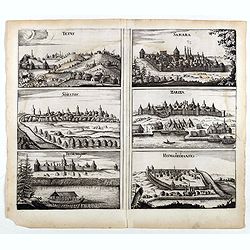
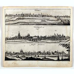
Tetus - Samara - Soratof - Zariza - Tzornogar - Kusmamedianski.
Panoramic views of Tetus, Samara, Soratof, Zariza, Tzornogar and Kusmamedianski on one sheet. From the rare first edition "Offt begehrte Beschreibung der newen orien...
- $300 / ≈ €256
Date: Schleßwig, Zur Glocken, 1647
Tarku.
An early of Tarku in the Republic of Dagestan. From the rare first edition "Offt begehrte Beschreibung der newen orientalischen Rejse, so durch Gelegenheit einer Ho...
- $250 / ≈ €214
Date: Schleßwig, Zur Glocken, 1647
Colomna - Cassimogorod - Moruma.
Three panoramic views of Colomna - Cassimogorod - Moruma on one sheet. From the rare first edition "Offt begehrte Beschreibung der newen orientalischen Rejse, so dur...
- $300 / ≈ €256
Date: Schleßwig, Zur Glocken, 1647
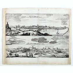
Die stadt Narva . . .
Two panoramic views of the city of Narva, on one sheet. Narva is the third largest city in Estonia. It is located at the eastern extreme point of Estonia, at the Russian...
- $250 / ≈ €214
Date: Schleßwig, Zur Glocken, 1647
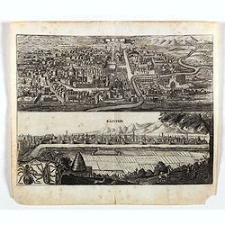
Kom - Kaschan.
An early of Kom and Kaschan on one sheet. From the rare first edition "Offt begehrte Beschreibung der newen orientalischen Rejse, so durch Gelegenheit einer Holstei...
- $250 / ≈ €214
Date: Schleßwig, Zur Glocken, 1647

Profil de la renomée ville et port d'Emstredam cappitalle des estats de Hollande.
Extremely rare panoramic town-view of Amsterdam seen from the river IJ.Exceptional bright, sharp example.The print is skillful copy of the print of Matthieu Merian, now w...
Date: Paris, 1647
Territorium Abbatiae Herefeldensis - 't Stift Hirszfeldt.
Detailed map centered on Hirschfelt. Title cartouche embellished with two cherubs.
- $250 / ≈ €214
Date: Amsterdam, 1647

Russiae vulgo Moscovia dictae, Partes Septentrionalis et orientalis.
In the north the Murmansk Sea. Including the western coast of Nova Zembla. Title cartouche and two cartouches, the bottom right one showing two hunters, bears, stags etc....
Date: Amsterdam, 1647

Rerum per octennium in Brasilia Et alibi nuper gestarum, Sub Praefectura Illustrissimi Comitis I. Mauritii, Nassoviae, (...) Historia.
First edition. Commissioned by Johan Maurits van Nassau (governor of Brazil between 1636-1644 and founder of "Mauritsstad" (present-day Recife)) and illustrated...
Date: Amsterdam, J. Blaeu, 1647
Brasilia.
Striking old color example of Blaeu's second map of Brazil prepared by Krystof Arciszewski, a Polish general who worked for the Dutch West Indian Company. The map perpetu...
- $750 / ≈ €641
Date: Amsterdam, 1647
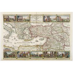
Geographische Beschryvinge van de wandeling der Apostelen. . .
Finely engraved detailed map covering the whole of the eastern Mediterranean. Showing the travels of the apostles after the death of Christ, with episodes from the life o...
Date: Amsterdam, 1648
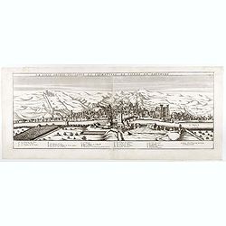
La ville archie-piscopale et primatiale de Vienne en Dauphiné.
View of Vienne, engraved by François de La Pointe.
- $600 / ≈ €513
Date: Paris, 1648
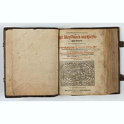
Itinerarium Sacrae Scripturae, dat is, Het Reysboeck der heyligher Schrift
This is a scarce 1648 Dutch edition of Büntings "Itinerarium Sacrae Scripturae" printed in Leeuwarden. The book includes 6 folding maps and 2 plates. The book ...
- $3000 / ≈ €2563
Date: Leeuwarden, de Vries, Jan Jansz., 1648
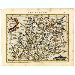
Ducatus Silesiae Glosani.
Charming map of the Silesia from the Mercator Hondius “Atlas Minor” published in Amsterdam in 1648 at Janssonius with German text on verso. Engraved by Petrus Kaerius...
- $200 / ≈ €171
Date: Amsterdam, 1648

Comitatus Flandria.
A highly decorative map with in the left and right top corners the pictures of archduke Albert of Austria and Isabella, queen of Spain. In the left and right borders cost...
Date: Amsterdam, 1648
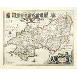
Penbrochia Comitatus et Comitatus Caermaridunum.
Attractive map of the country of Pembroke shire in UK by J. Blaeu. From a Dutch edition of "Atlas Maior" in beautiful color. With 13 coats of arms, the feathere...
Date: Amsterdam, 1648
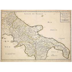
Royaume de Naples..
Fine map of the southern part of Italy.This edition carries the date 1648, engraved by AB. De la plaets. With the manuscript number in the upper right corner.Nicolas Sans...
Date: Paris, 1648
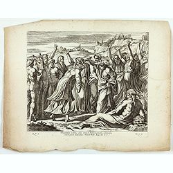
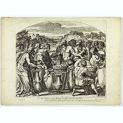
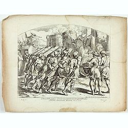
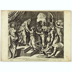
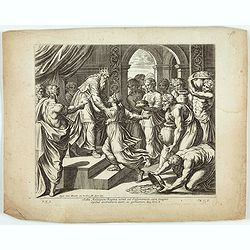
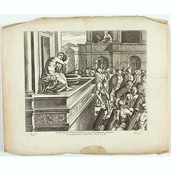
Sacerdos cornu olei unxit Salomonem omnisque clamauit. . . . ( Plate 45)
Fine etching by Nicolas Chapron, after Raphaël's (Raffaello Sanzio) frescoes in the Vatican Loggia. Scene illustrating a priest anointing Solomon with oil.From the first...
Date: Paris, Petrus Mariette, 1649
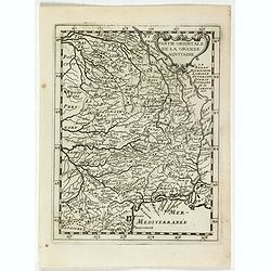
La partie orientale de la Grande Aquitaine.
Map taken from "Geographique Theater de l'Europe …, a rare work by the Jesuit priest Briet.
Date: Paris, 1649

Chorographica descriptio provinciarum, et conventum fratrum minorum S. Francisci Capucinorum...
All maps are good and dark impressions. Several maps with slight foxing and browning, the folding map with 2 splits (top right part 10 cm and lower left part 6 cm into en...
Date: Turin, 1649
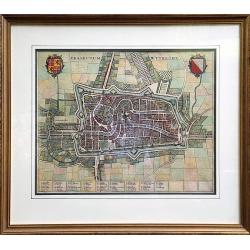
Traiectum Wttrecht
Fine plan of Utrecht from the townbooks "Novum Ac Magnum Theatrum Urbium Belgicae Liberae Ac Foederatae".FRAMED : Additional shipping costs apply. The item is l...
Date: Amsterdam, 1649
![[ The repositioning of the Vatican obelisk ]](/uploads/cache/49045-250x250.jpg)
[ The repositioning of the Vatican obelisk ]
Joan Blaeu published The Repositioning of the Vatican Obelisk. This large engraving on multiple sheets and in beautiful original colors is based on Domenico Fontana’s d...
Date: Amsterdam, 1649

Curia Hollandiae Interior. (Binnenhof)
The government center of the Netherlands is situated in and around the Binnenhof-Buitenhof in The Hague. In 1248 the Roman king Willem II built a castle here and named it...
Date: Amsterdam, 1649
Cataractae coeli apertoe funt: Et aguae proealuerunt super terram comfumptag Est omnis caro . . . (Plate 13)
Very nice etching by Nicolas Chapron, and after Raphaël's (Raffaello Sanzio) frescoes in the Vatican Loggia. Scene illustrating the moment when God said to Noah "Go...
- $25 / ≈ €21
Date: Paris, Petrus Mariette, 1649
Arca Dni septies circuit Ciuitatem et clangentib tubis. Jericho corruerunt Moenia. Iosue. CVI. ( Plate 38)
Very nice etching by Nicolas Chapron, after Raphaël's (Raffaello Sanzio) frescoes in the Vatican Loggia. Scene illustrating the walls of Jericho crumbling.From the first...
- $25 / ≈ €21
Date: Paris, Petrus Mariette, 1649
Portantes Arcam sacerdotes . . . (Plate 37)
Very nice etching by Nicolas Chapron, after Raphaël's (Raffaello Sanzio) frescoes in the Vatican Loggia. Scene illustrating Priests carrying the Ark through the River Jo...
- $25 / ≈ €21
Date: Paris, Petrus Mariette, 1649
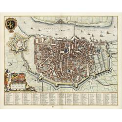
Wratislavia. Bresslaw.
Decorative town-plan of the Polish city of Wroclaw, once known as Breslau. The engraving is by the famed Swiss engraver Matthew Merian. A numbered key (1 - 38) the corner...
- $600 / ≈ €513
Date: Frankfurt, ca. 1649
Cataractae coeli apertoe funt: Et aguae proealuerunt super terram comfumptag Est omnis caro . . . (Plate 10)
Very nice etching by Nicolas Chapron, and after Raphaël's (Raffaello Sanzio) frescoes in the Vatican Loggia. Scene illustrating the moment when God said to Noah "Go...
- $50 / ≈ €43
Date: Paris, Petrus Mariette, 1649

Currus Veliferi Illmi. Pr. Mauritii Nassouvii. (Prince Maurits' sailing-carriage, designed by Simon Stevin. )
Prince Maurits' sailing carriages had been designed by Simon Stevin. The Prince, always accessible to new inventions of his old instructor, could not please the foreign a...
Date: Amsterdam, 1649
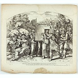
Saba Aethiopum Regina venit ad Salomonem, cum magnis Opibus aromatum, Auri, ac Gemmarum. ( Plate 47)
Fine etching by Nicolas Chapron, after Raphaël's (Raffaello Sanzio) frescoes in the Vatican Loggia. Scene illustrating the visit of the Queen of Sheba.From the first Par...
Date: Paris, Petrus Mariette, 1649
Saba Aethiopum Regina venit ad Salomonem, cum magnis Opibus aromatum, Auri, ac Gemmarum. ( Plate 47)
Very nice etching by Nicolas Chapron, after Raphaël's (Raffaello Sanzio) frescoes in the Vatican Loggia. Scene illustrating the visit of the Queen of Sheba at her visit ...
Date: Paris, Petrus Mariette, 1649
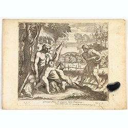
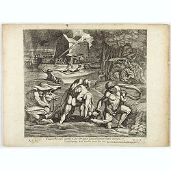
Concepit Heua & peperit Cain fratremg eius Abel. . . . (Plate 8)
Very nice etching by Nicolas Chapron, after Raphaël's (Raffaello Sanzio) frescoes in the Vatican Loggia. Scene illustrating Cain and Abel, a scene from Genesis IV.From t...
- $50 / ≈ €43
Date: Paris, Petrus Mariette, 1649
Antverpia, Gallis Anvers. Vernacule Antwerpen.
Detailed plan of the city of Antwerp with extensive key to principal buildings. Lower left title cartouche with two coats of arms and Mercurius.
Date: Amsterdam, 1649
Vidit David de Solario Domus regiae Bethsabeam . . . ( Plate 44)
Fine etching by Nicolas Chapron, after Raphaël's (Raffaello Sanzio) frescoes in the Vatican Loggia. Scene illustrating King David looking at Bathsheba bathing.From the f...
Date: Paris, Petrus Mariette, 1649
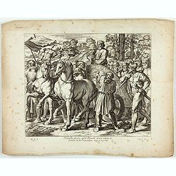
Svbacta Syria, tvlit David arma avrea, et detvlit ea in Jervsalem. ( Plate 43)
Fine etching by Nicolas Chapron, after Raphaël's (Raffaello Sanzio) frescoes in the Vatican Loggia. Scene illustrating David's conquest of Syria, during which he took th...
Date: Paris, Petrus Mariette, 1649
Regnum Galliae. . .
Map of France from the rare atlas of the Capucin order: "Chorographica descriptio provinciarum, et conventum fratrum minorum S. Francisci Capucinorum…".
Date: Turin, 1649
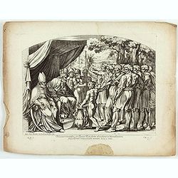
Eleazar sacerdos, et Iosue Rex sorte dividunt in Haereditatem Filiis Israel universam Terram ( Plate 49)
Fine etching by Nicolas Chapron, after Raphaël's (Raffaello Sanzio) frescoes in the Vatican Loggia. Scene illustrating Eleazar and Joshua to divide Canaan among the trib...
Date: Paris, Petrus Mariette, 1649
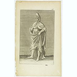
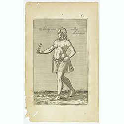
(Grand dame Turque. 45)
Sought-after copper engraved plate of a woman from Turkey. Plate from Laonikos Chalcocondyle’s "L'histoire de la décadence de l'empire grec et establissement de c...
Date: Paris, Mathieu Guillemot, 1650
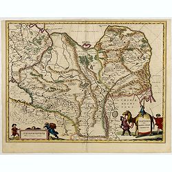
Magni Mogolis Imperium.
Important map of India, based upon William Baffin's map of India, first published in about 1619. The map is bounded by Pakistan, Afghanistan and Bangladesh and extends in...
Date: Amsterdam, 1650
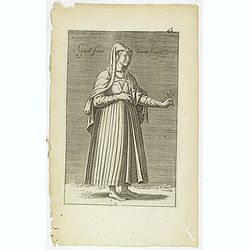
Gentille Femme Perotte Franque. (48)
Sought-after copper engraved plate of a woman from Pera, taken from Laonikos Chalcocondyle’s "L'histoire de la décadence de l'empire grec et establissement de cel...
- $100 / ≈ €85
Date: Paris, Mathieu Guillemot, 1650
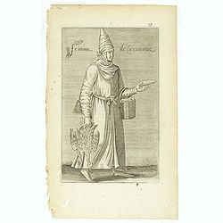
Femme de la Caramanie. (57)
Sought-after copper engraved plate taken from Laonikos Chalcocondyle’s "L'histoire de la décadence de l'empire grec et establissement de celuy des Turcs." by...
- $50 / ≈ €43
Date: Paris, Mathieu Guillemot, 1650
Femme moresque de Tripoly en Barbarie. (60)
Sought-after copper engraved plate of a woman with child from Tripoli. Plate from Laonikos Chalcocondyle’s "L'histoire de la décadence de l'empire grec et establi...
- $45 / ≈ €38
Date: Paris, Mathieu Guillemot, 1650
Fille Moresque esclave en Alger ville de Barbarie. (63)
Sought-after copper engraved plate of a young slave from Algeria. Plate from Laonikos Chalcocondyle’s "L'histoire de la décadence de l'empire grec et establisseme...
- $45 / ≈ €38
Date: Paris, Mathieu Guillemot, 1650
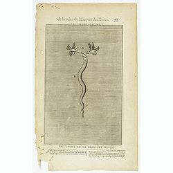
De la Ruine de l'Empire des Turcs Première figure / Epigramme de la première figure. (79)
Sought-after copper engraved plate taken from Laonikos Chalcocondyle’s "L'histoire de la décadence de l'empire grec et establissement de celuy des Turcs", th...
- $50 / ≈ €43
Date: Paris, Mathieu Guillemot, 1650
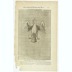
De la Ruine de l'Empire des Turcs Seconde figure / Epigramme de la Seconde figure. (81)
Sought-after copper engraved plate taken from Laonikos Chalcocondyle’s "L'histoire de la décadence de l'empire grec et establissement de celuy des Turcs", th...
- $50 / ≈ €43
Date: Paris, Mathieu Guillemot, 1650
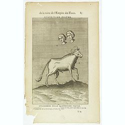
De la Ruine de l'Empire des Turcs Quatriesme figure / Epigramme de la Quatriesme figure. (85)
Sought-after copper engraved plate taken from Laonikos Chalcocondyle’s "L'histoire de la décadence de l'empire grec et establissement de celuy des Turcs", th...
- $50 / ≈ €43
Date: Paris, Mathieu Guillemot, 1650
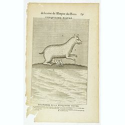
De la Ruine de l'Empire des Turcs Cinquiesme figure / Epigramme de la Cinquiesme figure. (87)
Sought-after copper engraved plate taken from Laonikos Chalcocondyle’s "L'histoire de la décadence de l'empire grec et establissement de celuy des Turcs", th...
- $50 / ≈ €43
Date: Paris, Mathieu Guillemot, 1650
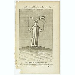
De la Ruine de l'Empire des Turcs Sixiesme figure / Epigramme de la Sixiesme figure. (89)
Sought-after copper engraved plate taken from Laonikos Chalcocondyle’s "L'histoire de la décadence de l'empire grec et establissement de celuy des Turcs", th...
- $50 / ≈ €43
Date: Paris, Mathieu Guillemot, 1650

Hassia Landgraviatus.
Centered on the town of Kassel.
Date: Amsterdam, 1650
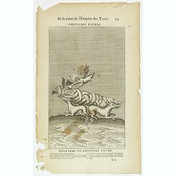
De la Ruine de l'Empire des Turcs Onziesme figure / Epigramme de la Onziesme figure. (99)
Sought-after copper engraved plate taken from Laonikos Chalcocondyle’s "L'histoire de la décadence de l'empire grec et establissement de celuy des Turcs", th...
- $25 / ≈ €21
Date: Paris, Mathieu Guillemot, 1650

