Search Listings matching "east-sea"

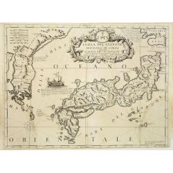
Asia carta di ciasete piu moderna. (Japan)
Rare FIRST STATE of this important map for Korea and Japan, a map of the Blancus/Moreira type, but adds a huge 'Jesso' filling the top of this old map. The map is of inte...
Date: Florence, 1646-1647

Carte des Isles du Japon Esquelles est remarque la Route..
This uncommon map of Japan, on a reasonably large scale, includes commentary on the country's natural features. For instance, Ocsaqui (Okazaki, near Nagoya) is said to ha...
Date: Paris 1679

Carte des Isles du Japon Sequels est remarque la Route..
This uncommon map of Japan, a reduced version of his larger map, contains comments about the nature of the country. For instance, Ocsaqui (Okazaki, near Nagoya) is said t...
Date: Paris / Amsterdam, 1679
-250x250.jpg)
Hern Johann Baptisten Taveniers..Vierzig Jaehrige Reize..
This German edition includes Tavernier's map of Japan in a reduced form (210x315mm) and contains legends about the country's nature, e.g., where gold is mined and plottin...
Date: Nuremberg, 1681

Isola del Giapone e penisola di Corea.
A most attractive and decorative map by Vincenzo Coronelli. An elaborate central title cartouche garlanded with intertwined flowers and dedicated to the Rev.de Fontaine o...
Date: Venice, 1692
Isola del Giapone e penisola di Corea.
A most attractive and decorative map of Japan and its near neighbour Korea by Vincenzo Coronelli. An elaborate central title cartouche garlanded with intertwined flowers ...
Date: Venice, 1692
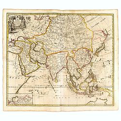
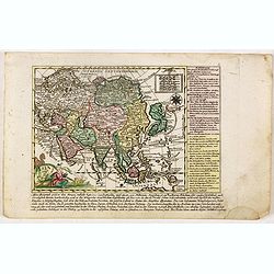
A New Map of Asia from the latest Observations Most Humbly Inscrib'd to the Right Honbl. George Earl of Warrington &c.
Fine map of Asia, with decorative title cartouche flanked by two figures in Asian dress, along with flora and fauna of the continent., based on the work of Guillaume De L...
Date: London, 1721

L'Asie suivant les nouvelles observations...
Uncommon edition of this map of Asia. From Le Nouveau Theatre du Monde, ou la Geographie Royale.The map is of interest for the use of Mer Orientale, the sea between Kor...
Date: Amsterdam, 1728

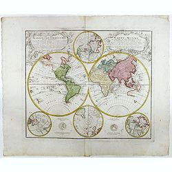
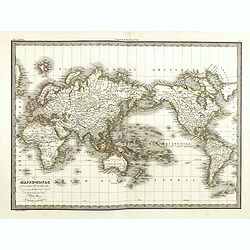
Carte Generale de la Terre ou Mappe Monde avec les quatres principaux systemes..
A rare double hemisphere world map, including the tracks of Tasman (1642) and Magellan (1520) and St. Antoine (1710) and surrounded with circular diagrams illustrating th...
Date: Paris, ca. 1729
![[World and 4 continents] Carte Geographique Astronomique Chronologique et Historique du Monde.](/uploads/cache/63024-250x250.jpg)
[World and 4 continents] Carte Geographique Astronomique Chronologique et Historique du Monde.
French wall map of the world in 4 sheets published by Crépy "à l'entrée du Cloistre de St. Benoist du côté des maturins". A decorative wall map of the worl...
Date: Paris, 1720-1735

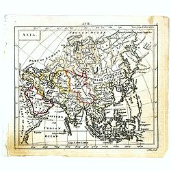
Asia By H.Moll Geographer.
Detailed map of Asia. From his "Atlas minor: or a new and curious set of sixty-two maps. . .", which was first published in 1729 and reprinted in 1732, 1736.The...
Date: London, 1736
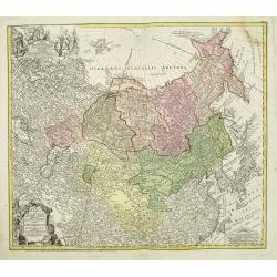
Imperii Russici et Tartariae Universae tam majoris Afiaticæ quam minoris et EuropæTabula.
The map is of interest for the use of East Sea, the sea between Korea and Japan, here called "Mere Orientale Minus".Decorative map covering Russia, Tibet, China...
Date: Nuremberg, 1739

Globe Terrestre Didié et Présénté a Monseigneur le Comté Maubec de Brancas...
A rare terrestrial globe dated 1741. Complete title "Globe Terrestre Didié et Présénté a Monseigneur le Comté Maubec de Brancas Par Jacque Hardy. Dres...
Date: Paris, dated 1741

Kaartje van Asia. . .
Attractive and rare map of Asia. From Atlas Portatif . With a curious and oversized Hokkaido. The map is of interest for the use of Coreanse Zee for the sea between Korea...
Date: Deventer 1742

Kaartje van Asia. . .
Attractive and rare map of Asia. From Atlas Portatif . With a curious and oversized Hokkaido. The map is of interest for the use of Corease Zee for the sea between Korea ...
Date: Deventer, 1742

Asia secundum legitimas projectionis stereographicae.
Highlighted area covers part of Spain, eastern coast of Ireland to western part of Papua New Guinea and the Asian continent from the Northern Polar Sea to the Indian Ocea...
Date: Nurenberg, 1744
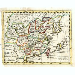
Het Keizerryk van China, volgens de Nieuwste Waarneminge opgesteld.
A scarce and uncommon miniature map of China, Korea and Taiwan. The map is of interest for the use of De Zuid Zee for the sea between Korea and Japan.
- $300 / ≈ €262
Date: Amsterdam, 1745

Le Théâtre du monde dédié au roi contenant les cartes générales et particulières des royaumes et états qui le composent.
The present example of the Théâtre du monde is the reissue of 1746 by Jean-Baptiste Nolin II. This scarce atlas is illustrated with 123 maps mostly double-page, in orig...
Date: Paris, 1746
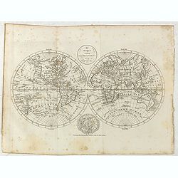
Planiglobii Terrestris Mappa Universalis.. - Mappe-Monde qui represente les deux Hemispheres. . .
Word map in double hemisphere. In center two smaller hemispheres of the north and south pole are shown. Two interesting diagrams depict the earth as it would be seen from...
Date: Nuremberg, 1746
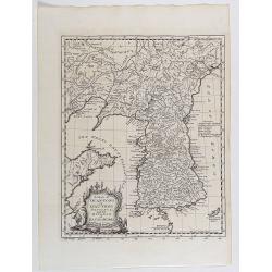
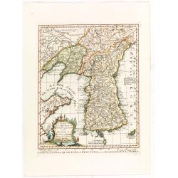
A map of Quan-Tong or Lyau-Tong province, and the kingdom of Kau-Li or Korea . . .
Detailed map of Korea, Liaodong, and the tip of Shandong Province prepared by Thomas Kitchin for Thomas Salmon's Universal Traveller, based on D'Anville's landmark map of...
Date: London, 1747
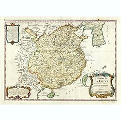
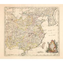
L'Empire de la Chine.
A fine map of China, Korea and Taiwan.Jacques Nicholas Bellin (1703-1772) was one of the most important and proficient French cartographers of the mid-eighteenth century....
- $450 / ≈ €394
Date: Paris, 1748
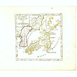
Le Japon Par le Sr. Robert de Vaugondy fils de Mr. Robert Geog. Ord du Roi avec Privilege 1749.
Small detailed map of Japan and Korea. From Atlas Portatif Universel, by Robert de Vaugondy.Page 168 outside border top right. First state. The map is of interest for the...
Date: Paris, 1749
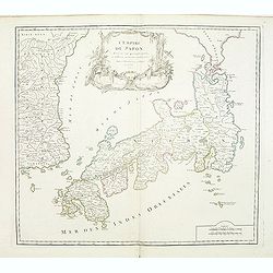
L'Empire du Japon divisé en sept principales parties. . .
Large map of Japan and Korea with a distinctively French style title cartouche containing two small landscapes.The map draws heavily on the previous work of Bellin, but i...
Date: Paris, 1750

Karte von Katay od. dem Reiche Kin, zur Geschichte von Jenghiz Khan. Aus dem Englischen.
The map is of interest for the use of East Sea, the sea between Korea and Japan, here called "Meer von Corea".Copper engraving, hand colored in outline and wash...
Date: Leipzig, Schwabe, ca. 1750

Carte du Katay ou Empire de Kin. . .
The map is of interest for the use of Mer de Corée for the sea between Korea and Japan. Fine map of Korea and China's Yellow Sea. Complete title in top: Carte du Katay o...
Date: Paris, 1750

A new & accurate map of the Empire of China from the Sieur Robert's Atlas. With improvements.
An excellent early engraving of China and Korea that appeared in Sieur Robert de Vaugondy's Geographical Dictionary (London: 1759). Decorative title cartouche on the uppe...
Date: London, 1759
China as surveyed by the Jesuit Misionaries between the years 1708 & 1717 with Korea & the adjoining parts of Tartary.
The map is of interest for the use of Eastern Sea or Sea of China, the sea south of Korea. In the sea along the coast line of Korea : "Kau-Li-Qua or King:m of Korea&...
Date: London, c. 1760

Matching set of four wallmaps of America, Asia, America, Europe.
1760 Louis Charles DESNOS - Rare and decorative set of four continents, including a border with vignettes describing native scenes.
Date: Paris, 1760-1761
Asia.
Uncommon miniature map of Asia. The map is of interest for the use of Sea of Corea, for the sea between Korea and Japan.Engraved by J.Ellis for "A New General and Un...
- $150 / ≈ €131
Date: London, 1761-1763

(upper sheets only) Asia According to the Sieur D'Anville Divided into its Empires, Kingdoms and States Showing the European Settlements in the East Indies and all the New Discoveries . . . 1772
Highly detailed map of Russia, including Turkey, China and Korea. Based on the cartography of the famous French cartographer Jean Baptiste Bourguignon d' Anville. Only th...
Date: London, 1772
Carte de la province de Quan-tong, ou Lyau-tong et du Royaume de Kau-li ou Corée. . . / Kaart van t' Landschap Quan-Tong . . .
Uncommon issue of this fine map of Korea. The map is of interest for the use of East Sea, the sea between Korea and Japan, here called "Mer de Corée.Decorative titl...
Date: Paris, 1749-1773
![[Set of five maps] Carte Generale de la Terre ou Mappe Monde avec les Quatres Principaux Sistemes . . . 1776 (with) Carte D'Amerique ... (and) Carte D'Afrique . . . (and) Carte d'Asie) (and) Carte D'Europe . . . 1776](/uploads/cache/41145X-250x250.jpg)
[Set of five maps] Carte Generale de la Terre ou Mappe Monde avec les Quatres Principaux Sistemes . . . 1776 (with) Carte D'Amerique ... (and) Carte D'Afrique . . . (and) Carte d'Asie) (and) Carte D'Europe . . . 1776
Rare and decorative set of five wall maps of the world and the four continents, prepared by Clouet, in very fine, bright contemporary coloring. Each map ca. 965 x 1230 mm...
Date: Paris and Cadiz, Mondhare, 1776
A new and accurate map of Asia, Drawn from the most approved modern maps & charts / by Thos. Bowen.
The map is of interest for the use of Sea of Korea for the sea between Korea and Japan.Detailed map of Asia from Saudi Arabia, Persia, Russia, India, China, Japan to Sout...
Date: London, J.Cooke, 1777-1778
La China e Giapone.
Rare map of China, Korea and Japan, from "Atlante Novissimo ad uso Dei Giovani Studiosi Contenuto In Carte XXVII.", published by Giovanni Zempel in Rome, ca. 17...
- $300 / ≈ €262
Date: Rome, 1780
The world, including the discoveries made by Capt. Cook.
Uncommon double-hemisphere world map depicting the voyages and discoveries of Captain James Cook. There are numerous notations throughout and the tracks of Cook's three v...
- $1000 / ≈ €875
Date: London, 1781

Nouvelle Mappa Monde.
State 2 of this fine double hemisphere world map, from an unusual perspective, with a "Mer de L'Ouest" or "Sea of the West". Paris is located at the c...
Date: Venice, 1776 - 1784
Carte des nouvelles decouvertes au Nord de la Mer du Sud.
Although concentrating on the northern Pacific, this map shows all of North America and Mexico.While the Russian coastline is shown with reasonable accuracy, notwithstand...
- $1800 / ≈ €1575
Date: Venice, 1776 - 1784

L'Asie divisée en ses principaux Etats..
A finely and crisply engraved map of Asia is decorated with an ornamental title cartouche in the lower-left corner.There are very good details of towns in modern-day Uzbe...
Date: Venice, 1776 - 1784

Carte d'Asie divisée en ses principaux Etats.
Uncommon and decorative "carte à figures" - wall map, prepared by Clouet, with superb decoration, including a wonderful rococo border with 20 decorative vignet...
Date: Paris, Mondhare, 1787
Asia verlegt von Ioh Mich Probst.
Uncommon map of Asia, with an explanatory text and directory on the right and the bottom of the map from the "Atlas Minor ex Tabulis Geographicis ".The map is o...
- $300 / ≈ €262
Date: Augsburg, 1789

The Russian Empire in Europe and Asia . . .
Detailed map of the whole of Russia, extending from Poland to the Pacific and from Nova Zembla to Tartaria.The map is of interest for the use of Corea Gulf for the sea be...
Date: London, 1790
![Die Obere oder Nordliche Halbkugel der Erde auf den Horizont von Wien, Sterographisch Entworfen ... [together with] Die Untere oder Sudliche Halbkugel der Erde auf den Horizont von Wien, Stereographisch ...](/uploads/cache/39377-250x250.jpg)
Die Obere oder Nordliche Halbkugel der Erde auf den Horizont von Wien, Sterographisch Entworfen ... [together with] Die Untere oder Sudliche Halbkugel der Erde auf den Horizont von Wien, Stereographisch ...
A set of two uncommon large format maps of the Northern and Southern Hemisphere, based upon the work of Johann Anton Ecker (1755-1820). First published in 1794, this is t...
Date: Vienna, Phil. Jos Schalbacher, 1800

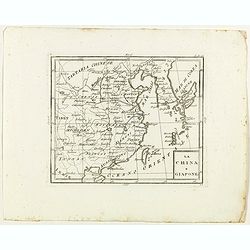
La China e Giapone.
Uncommon map of China, Korea, Japan and Taiwan (I.Formosa), only one town labeled, Tayoan. Very strange shape for Japan.The map is of interest for the use of Mar di Corea...
Date: Italy, ca. 1800
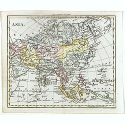
Asia.
The map is of interest for the use of Gulf of Corea, the sea between Korea and Japan.William Darton, Sr. started his mapmaking business in 1787 in London, and thus began ...
- $300 / ≈ €262
Date: London, 1802
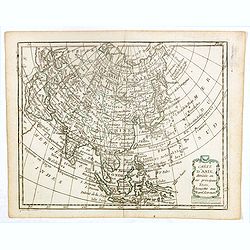
Carte d'Asie . . .
Map of the Asian continent, from Atlas moderne portatif composé de vingt-huit cartes sur toutes les parties du globe terrestre .. A l'usage des Colléges, des Pensions &...
- $230 / ≈ €201
Date: Paris, Prudhomme, Levrault, Debray, 1806

Siberie ou Russie Asiatique, Tartarie Chinoise, Pays des Eluts et Isles du Japon.
Map of the Kamchatka peninsula, Russian Far East., Korea, Japan, with Hokkaido labeled "Terre del Jeso".By C. F. Delamarche, successor of Robert de Vaugondy, Ge...
Date: Paris, 1794 - 1806

Asia.
Uncommon map of Asia. Engraved by Marco di Pietro.The map is of interest for the use of G. di Corea, for the sea between Korea and Japan.Published by Carlo Antonio Barbie...
Date: Milan, 1807
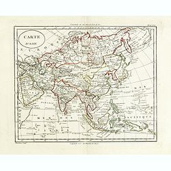
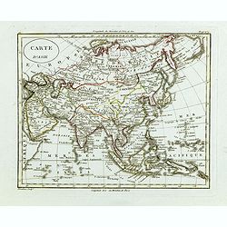
Carte d'Asie.
Fine map of Asia, with an interesting representations of Japan, Hokkaido, Sakhalin Island, Kamchatka and Korea. Engraved by Alexandre Blondeau, who also worked for Depôt...
Date: Paris, c. 1810
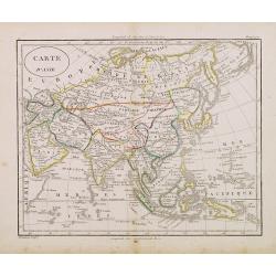
Carte d'Asie.
Fine map of Asia, with an interesting representation of Japan, Hokkaido, Sakhalin Island, Kamchatka, and Korea. Engraved by Alexandre Blondeau, who also worked for Depôt...
- $175 / ≈ €153
Date: Paris, c. 1810
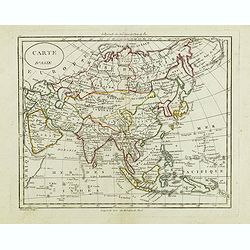
Carte d'Asie.
Fine map of Asia, with an interesting representations of Japan, Hokkaido, Sakhalin Island, Kamchatka and Korea. Engraved by Alexandre Blondeau, who also worked for Depot ...
- $150 / ≈ €131
Date: Paris, c. 1810
Carte d'Asie.
Fine map of Asia, with an interesting representations of Japan, Hokkaido, Sakhalin Island, Kamchatka and Korea. Engraved by Alexandre Blondeau, who also worked for Depôt...
Date: Paris, c. 1810
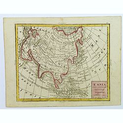
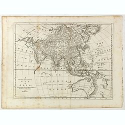
L'Asia...
A small, uncomplicated map of Asia with outline coloring. Map extends down from the Arctic Circle to Java and New Guinea. From Arabia in the west to Japan in the east.Sma...
- $175 / ≈ €153
Date: Venezia, 1810
Mappemonde sur la projection de Mercator Dressee par Mr Lapie, Lieut. Colonel. et Mr Lapie, fils capitaine d'Etat major, Paris 1832.
Very detailed world map with Australia in the center and prepared by Pierre M. Lapie (fl. 1779 - 1850) and his son Alexandre Emile Lapie (fl. 1809 - 1850).Engraved by Lal...
Date: Paris, 1832

Siberia & Central Asia.
This map covers the eastern section of Russia as well as China, Japan, Korea, India and Tibet. The map is of interest for the use of Sea of Corea, the sea between Korea a...
Date: Boston, 1835
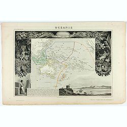
Océanie.
A very decorative 19th century map of the Pacific Ocean, with hand colored lines indicating the extent of Polynesia, Micronesia, Melanesia, and Malaysia (or Southeast Asi...
Date: Paris, 1850
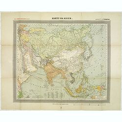
General Karte von Asien. Entworfen und gezeichnet von F. Handtke.
In upper left corner "Carl Flemmings Generalkarten No. / Nr. 37" in a 17th edition. Prepared by Friedrich Handtke (1815-1879). Scale 1: 18.886.000, with a key i...
Date: Glogau, Carl Flemming, c.1910
