Browse Listings in World Maps
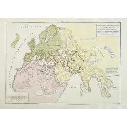
Il mondo cocsciuto dagli antichi e le laggiori antiche monarchie Persiana, Macedone, Romana . . .
A rare double-page map of the so-called Empire of Alexander the Great (also known as the Macedonian Empire or the Hellenistic Empire ) refers to that great empire , which...
Date: Venice, 1840
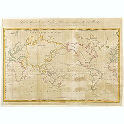
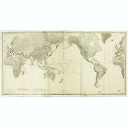
Carte Générale de Voyage Pittoresque Autour du Monde.
A map of the world centered on the Pacific Ocean. Engraved by Ambroise Tardieu.Jules Sébastien César Dumont d'Urville (1790 – 1842) was a French explorer, naval officer a...
- $125 / ≈ €109
Date: Paris, ca. 1840
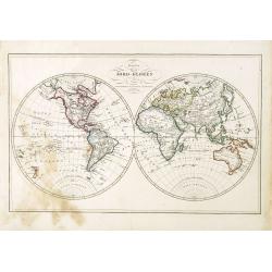
Karta öfver Jord-Globen (World map)
An very rare double hemisphere world map. This is an heavenly updated version of his map of 1817 and is now dated 1848, Australia with new nomenclature and the old title ...
Date: A. Wiborgs förlag, Stockholm, ca. 1848
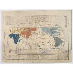
Chikyu Bankoku sankai yochi zenzu setsu. / Sekisui Cho Harutaka. (Map and description of geography of all the countries of the globe).
Reduced version of the famous map "Kaisei chikyu bankoku zenzu" by Sekisui Nagakubo (1717-1801) published ca. 1785, still based on the one by Matteo Ricci. Incl...
- $3500 / ≈ €3060
Date: Tokyo, 1850
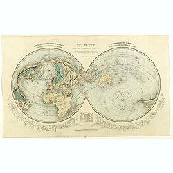
The Earth projected on the horizon of London.
Double hemisphere orientated on the north and south poles.
- $150 / ≈ €131
Date: London, 1850
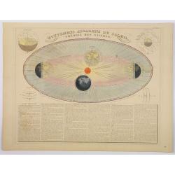
Mouvemens Apparens du Soleil, Theorie des Saisons.
A nice and attractive example of Andriveau-Goujon's decorative chart depicting the theory of the seasons as the earth orbits the Sun in an elliptical fashion, with 4 smal...
Date: Paris 1850
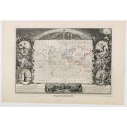
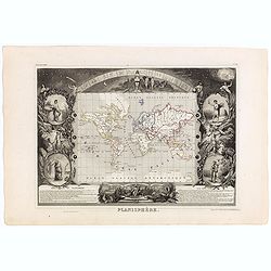
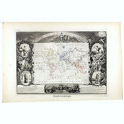
Planisphère.
One of the last decorative maps of the area. In side panels representations of the four seasons. In original o.l. color, from his "Atlas Universel Illustré". Th...
Date: Paris, 1850
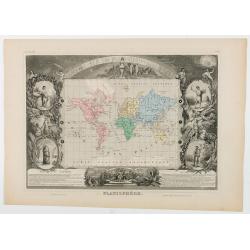
Planisphère.
One of the last decorative maps of the area. In side panels representations of the four seasons. In original o.l. color, from his "Atlas Universel Illustré". Th...
Date: Paris, 1850
Planisphère.
One of the last decorative maps of the area. In side panels representations of the four seasons. In original o.l. color, from his "Atlas Universel Illustré". Th...
Date: Paris, A. Combette, 1852
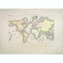
The World on Mercator's projection.
World map in Mercator-projection, published by "The London Printing and Publishing Company". Drawn and engraved by John Rapkin.
- $110 / ≈ €96
Date: London, 1854
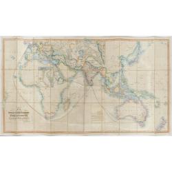
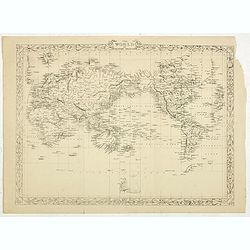
The Pathways of Empire Delineated: Map Showing The Steam Comunication And Overland Routes between England, India, China & Australia…
An illuminating and attractive map that illustrates one of the foundations of British imperial power--the key trade routes by both land and sea between England and its fa...
Date: London, 1856
Planisfero (Tav III)
A large-format world map with a key to the steamship routes, telegraph lines and land routes in Europe. Finely engraved and beautifully colored and was prepared by Girola...
Date: Rome, 1858
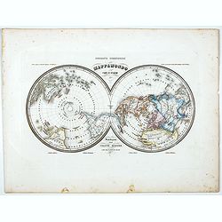
Mappamondo Carta d'Insieme.
Uncommon double hemisphere pole projection prepared by Francesco Costantino Marmocchi. Above the map "Geografia Commerciale". With a color code underneath the m...
Date: Genova, Paolo Rivara fu Giacomo, 1858
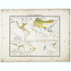
Distribuzione geografica delle Pianta coltivate . . .
Uncommon world map in Mercator projection representing food resources on 3 inset maps, prepared by Francesco Costantino Marmocchi. Above the map "Geografia Commercia...
Date: Genova, Paolo Rivara fu Giacomo, 1858
![[Double-hemispher World Map] Descrizione del Globo in due emisferi . . .](/uploads/cache/44079-250x250.jpg)
[Double-hemispher World Map] Descrizione del Globo in due emisferi . . .
This large-format map is finely engraved and beautifully colored and was prepared by Girolamo Petri, a lawyer who served as a senior official within the Vatican’s State S...
- $1750 / ≈ €1530
Date: Rome, 1858
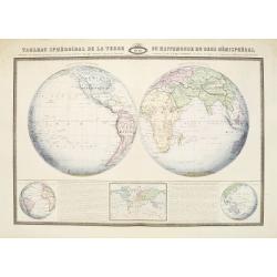
Tableau Sphéroïdal de la Terre ou Mappemonde en deux Hémispères. . .
Large steel engraving presenting the whole World in different projections, namely showing the convexity of the Earth.At the bottom a temperature contour map of the world ...
Date: Paris, 1860
Planisphère.
One of the last decorative maps of the area. In side panels representations of the four seasons. In original out line color, from his "Atlas Universel Illustré"...
Date: Paris, 1845-1860
![Jules Verne. Le Tour du Monde en 80 jours. [Goose game board inspired by Jules Verne's novel Tour du Monde en 80 jours.]](/uploads/cache/44962-250x250.jpg)
Jules Verne. Le Tour du Monde en 80 jours. [Goose game board inspired by Jules Verne's novel Tour du Monde en 80 jours.]
This Goose game board is inspired by Jules Verne's novel whose boxes are illustrated with town views and figures and the center is occupied by a world map. Vignette illus...
- $1100 / ≈ €962
Date: Paris, 1876
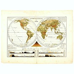
Hypsometrisch Overzicht der Aarde.
One of the earliest thematic world maps published in the Netherlands from "Atlas der natuurkundige aardrijkskunde. . .". prepared by Nicolaas Wilhelmus Posthumu...
- $50 / ≈ €44
Date: Amsterdam, C.L. Brinkman, 1883
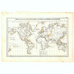
Kaart, voorstellende de Seculaire Rijzingen en Dalingen van den Bodem, alsmede de Vulkamen.
One of the earliest thematic world maps published in the Netherlands from "Atlas der natuurkundige aardrijkskunde. . .". prepared by Nicolaas Wilhelmus Posthumu...
- $35 / ≈ €31
Date: Amsterdam, C.L. Brinkman, 1883
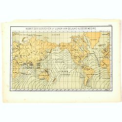
Kaart der Isorachiën of Lijnen van Gelijke Vloedbeweging.
One of the earliest thematic world maps published in the Netherlands from "Atlas der natuurkundige aardrijkskunde. . .". prepared by Nicolaas Wilhelmus Posthumu...
- $35 / ≈ €31
Date: Amsterdam, C.L. Brinkman, 1883
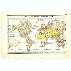
Kaart van de Hoofdgodsdiensten.
One of the earliest thematic world maps published in the Netherlands from "Atlas der natuurkundige aardrijkskunde. . .". prepared by Nicolaas Wilhelmus Posthumu...
- $35 / ≈ €31
Date: Amsterdam, C.L. Brinkman, 1883
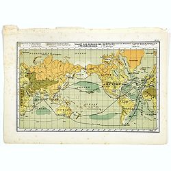
Kaart der Oceanische Stroomgebieden.
One of the earliest thematic maps published in the Netherlands from "Atlas der natuurkundige aardrijkskunde. . .". prepared by Nicolaas Wilhelmus Posthumus. The...
- $35 / ≈ €31
Date: Amsterdam, C.L. Brinkman, 1883
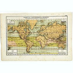
Kaart der Oceanische Stroomgebieden.
One of the earliest thematic maps published in the Netherlands from "Atlas der natuurkundige aardrijkskunde. . .". prepared by Nicolaas Wilhelmus Posthumus. The...
- $35 / ≈ €31
Date: Amsterdam, C.L. Brinkman, 1883
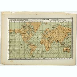
Kaart der Isodynamen.
One of the earliest thematic maps published in the Netherlands from "Atlas der natuurkundige aardrijkskunde. . .". prepared by Nicolaas Wilhelmus Posthumus. The...
- $35 / ≈ €31
Date: Amsterdam, C.L. Brinkman, 1883
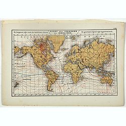
Kaart der Isogonen en Isoklinen.
One of the earliest thematic maps published in the Netherlands from "Atlas der natuurkundige aardrijkskunde. . .". prepared by Nicolaas Wilhelmus Posthumus. The...
Date: Amsterdam, C.L. Brinkman, 1883
![[World map with oceanic currents].](/uploads/cache/46149-250x250.jpg)
[World map with oceanic currents].
Alexey Afinogenovich Ilyin was a lieutenant general and cartographer (1832-1889). In 1856, after graduating from the Academy of the General Staff, he was at the military ...
- $100 / ≈ €87
Date: St. Petersburg, 1899
![[Rain Distribution].](/uploads/cache/46151-250x250.jpg)
[Rain Distribution].
A detailed map from Учебный Географический Атлас published by the very successful St. Petersburg publisher "Cartographic institution A.Ilina" ("Картографич...
Date: St. Petersburg, 1899
![[Isothermal Linti].](/uploads/cache/46152-250x250.jpg)
[Isothermal Linti].
A detailed map from Учебный Географический Атлас published by the very successful St. Petersburg publisher "Cartographic institution A.Ilina" ("Картографич...
Date: St. Petersburg, 1899
![[Religion Map].](/uploads/cache/46153-250x250.jpg)
[Religion Map].
A detailed map from Учебный Географический Атлас published by the very successful St. Petersburg publisher "Cartographic institution A.Ilina" ("Картографич...
Date: St. Petersburg, 1899
![[Euroidenic Columns all parts of the light].](/uploads/cache/46171-250x250.jpg)
[Euroidenic Columns all parts of the light].
A detailed map from Учебный Географический Атлас published by the very successful St. Petersburg publisher "Cartographic institution A.Ilina" ("Картографич...
Date: St. Petersburg, 1899
![[Board game] - La course autour du Monde.](/uploads/cache/48521-250x250.jpg)
[Board game] - La course autour du Monde.
Very rare French board game - no other copies known. The game consists of 50 fields linked to the lines of longitude. A globe lies in the center of the board to symboli...
Date: Paris, ca. 1900
![[World map in showing currents with Ottoman script]](/uploads/cache/44322-250x250.jpg)
[World map in showing currents with Ottoman script]
Post card size world map in Mercator projection showing the currents in Atlantic and Pacific Oceans in Ottoman script prepared by Mehmet EŞREF in a small atlas : عمومولا...
Date: Istanbul, 1325 or 1909
![[Set of two maps showing world in Mercator projection, with Ottoman script]](/uploads/cache/44328-250x250.jpg)
[Set of two maps showing world in Mercator projection, with Ottoman script]
Two postcard size maps showing the entire world in Mercator projection. The maps are in Ottoman script prepared by Mehmet EŞREF in a small atlas : عمومولاياةىشهانيىحاوىك...
Date: Istanbul, 1325 or 1909
Planisphère terrestre.
A huge (2 meters) world map representing Asia and America in the center, Europe and Africa at left and right hand of the map. Published by the Service hydrographique in 1...
- $800 / ≈ €699
Date: Paris, Service hydrographique, 1902-1914
![Tutte le strade conducono a Roma. [All roads lead to Rome]](/uploads/cache/44998-250x250.jpg)
Tutte le strade conducono a Roma. [All roads lead to Rome]
Game board of the game "All roads lead to Rome" from the Fascist era, offered by the chocolate or cocoa company Talmone-Unica. Showing a world map surrounded by...
- $1500 / ≈ €1311
Date: Turin, 1928

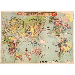
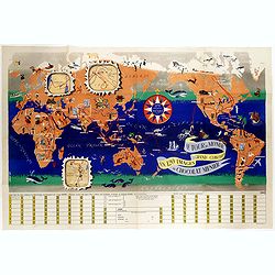
World Flight Routes (all in Japanese).
A large, very decorative Japanese world map published as sugoroku (a Japanese game which might be compared to backgammon), published as a supplement to the 1930 New Year’...
Date: Osaka, 1930
Index Geographicus Tum veteristum novae cognitae Terrae. . .
This rare and decorative advertising poster uses the world map by Presbyter Chrysanthos, who was the Patriarch of Jerusalem. In the top we see John Constantine Bessaraba ...
Date: Paris, ca. 1930
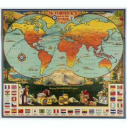
McCormick's Map of the World.
Colorful promotional map of the 20th century spice trade.What better way to showcase the global composition of a multi-national company than with a world map? This lovely...
Date: United-States, 1931
Japanese Stereotype Map of the World from 1932 Share Hitome de wakaru Manga sekai genjō chizu. At a glance: Cartoon Map of the Current World Situation. 目でわかる 漫画世界現状地圖
An extraordinary satirical map of the world was seen through Japanese eyes in the early 1930s as Japanese imperial ambitions strengthened. The map was published as an edi...
Date: Tokyo, Showa 7, or 1932
![[Magazine including pictorial world map, Carriers of the New Black Plague by William Cotton.]](/uploads/cache/43680-250x250.jpg)
[Magazine including pictorial world map, Carriers of the New Black Plague by William Cotton.]
Front cover with color illustration of a Moroccan male sheik and yellow lettering.Oversized magazine, features analysis of English justice, map of Herr Hitler's heaven (f...
Date: Chicago, April 7th, Vol.1 No.1 1938
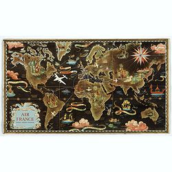
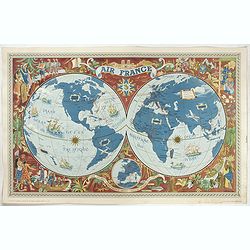
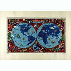
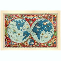
AIR France réseau arérien mondial.
Original lithograph advertising planisphere cardboard from AIR France. The map is designed by Lucien Boucher and is in fact a reduced version of his larger format poster....
Date: Imprimerie Perceval, Paris, 1938
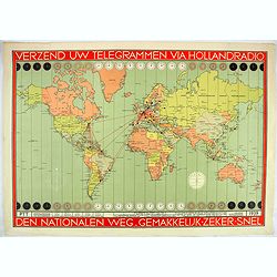
Verzend uw telegrammen via Holland Radio Den Nationalen weg. Gemakkelijk -Zeker - Snel.
Poster showing a world map in Mercator projection. In top and bottom clocks showing the time zones. Red lines connecting The Netherlands with different major hubs in Amer...
Date: The Netherlands, 1939

Nous vaincrons parce que nous sommes les plus forts. Souscrivez aux bons d'armement.
We win because we are the strongest. Support good armaments". Quote by the French Prime Minister Paul Reynaud. French wartime propaganda poster. colored world map - ...
Date: Pars, ca. 1939
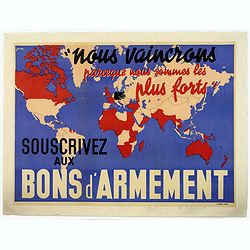
Nous vaincrons parce que nous sommes les plus forts. Souscrivez aux bons d'armement.
We win because we are the strongest. Support good armaments". Quote by the French Prime Minister Paul Reynaud. French wartime propaganda poster. colored world map - ...
- $600 / ≈ €525
Date: Paris ca 1939
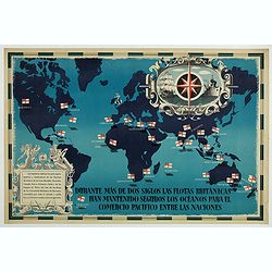
British Empire Trade Map WWII Eric Fraser.
Original vintage World War Two period British Empire trade map poster with the stylised text in Spanish reading: For more than two centuries the British fleets have kept ...
Date: England, 1941
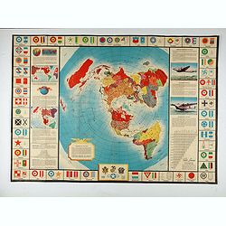
![[Mussolini Celebrates Pearl Harbor] Grande Carta Del Pacifico](/uploads/cache/48536-250x250.jpg)
[Mussolini Celebrates Pearl Harbor] Grande Carta Del Pacifico
A world map issued four days after the Japanese attack on Pearl Harbor, which led England and the United States to declare war on Japan, this message from Mussolini, cele...
- $500 / ≈ €437
Date: Rome / Milan, 1941
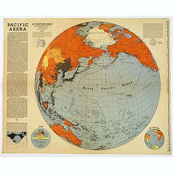
Pacific Arena
1942 FORTUNE MAGAZINE. - Second World War map covering the Pacific regions. Printed as Supplements to 'Fortune' in March 1942
Date: New York, 1942
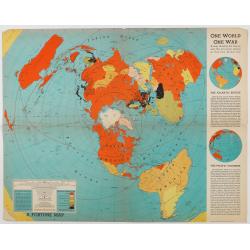
One World One War.
A large, brightly colored second world war world map, oriented on the north pole. Printed as Supplements to 'Fortune' in March 1942. This world map also comes with some ...
Date: New York, 1942

Carte de la Charte de L'Antique . . .
The rare French version of this decorative pictorial world map by MacDonald Gill. "This magnificent map drawn up while the Second World War still raged is already en...
Date: London, Alf Cooke Ltd, 1943
Freedom of the Air.
A world map packed with information about aviation and the aluminum industry.The use of aircraft in warfare, especially in the roles of close ground support and strategic...
- $230 / ≈ €201
Date: United-States, 1943
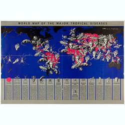
World Map of the Major Tropical Diseases.
A gruesome overview of some of the world’s deadliest tropical diseases designed by Boris Artzybasheff.This graphic world map uses hideous imagery and vivid color to highl...
- $270 / ≈ €236
Date: London, 1944
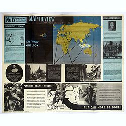
Map Review No.17. Eastwood Outlook.
A large double-sided 'current affairs' poster. One side features an eastern hemisphere world map and addresses matters arising in Southeast Asia, the Far East, and Europe...
Date: London, 1946
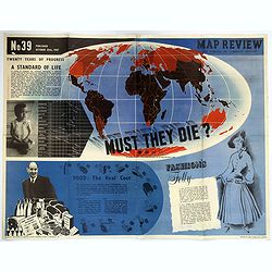
Map Review No.39. - Twenty Years of Progress, 'A Standard of Life'.
A large, fully colored, double-sided poster of the world colored to highlight the number of children who die each year before the age of one. This is accompanied by a sho...
Date: London, 1947
![Les Forbans [Board game]](/uploads/cache/49165-250x250.jpg)
Les Forbans [Board game]
Game board designed by Lucien Boucher, without any randomness, which is rare for that time. The board which is cut in four parts show a world map drawn by Lucien Boucher....
Date: Paris, Perceval, ca. 1950
![[ Pictorial world map ]](/uploads/cache/44376-250x250.jpg)
[ Pictorial world map ]
1951 LIOZU, J. - A pictorial world map, drawn by Jacques Liozu, including a decorative title cartouche and a compass rose.
Date: Paris, 1951
Sur les ailes d'Air France découvrez le monde à votre tour.
Promotional mid-size poster of a double hemisphere world map designed by Lucien Boucher for AIR France. The map depicts the entire world in rich blues and burgundies with...
- $1100 / ≈ €962
Date: Imprimerie Goosens, Paris, 1952
AIR France - Sur les ailes d'Air France découvrez le monde à votre tour.
Promotional poster of a double hemisphere world map designed by Lucien Boucher for AIR France. The map depicts the entire world in rich blues and burgundies with gold hig...
Date: Perceval, Paris, 1952
AIR France - Sur les ailes d'Air France découvrez le monde à votre tour.
Promotional poster of a double hemisphere world map designed by Lucien Boucher for AIR France. The map depicts the entire world in rich blues and burgundies with gold hig...
Date: Perceval, Paris, 1952
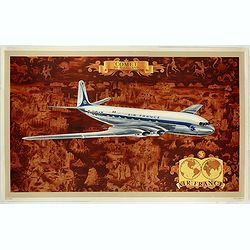
AIR France - Comet De Havilland
Promotional poster attributed to Lucien Boucher showing the Comet de Havilland on a Mercator projection world map. The map depicts a pictorial map of the entire world in ...
Date: Perceval, Paris, 1953
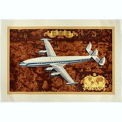
AIR France - Super constellation, Lockhead L - 10 - 49.
Promotional poster attributed to Lucien Boucher showing of a Lockhead L - 10 - 49 on a Mercator projection world map. The map depicts a pictorial map of the entire world ...
Date: Perceval, Paris, 1953

(World map). Americus Vespucio novo te Duce Ducta Freto Ambivi Meritoqs Vocor.
Manuscript world map showing the American and African continent and the southern parts of Asia. In the Indian Ocean a large depiction of Amerigo Vespucci 1454 – 1512) on ...
Date: Italy, ca. 1954
![Air France [poster].](/uploads/cache/44299-250x250.jpg)
Air France [poster].
A superb double-sided Air France folding poster, featuring bold colored graphics. Published as a serious piece of marketing put out by the airline showing off their state...
Date: Paris, 1955
![Air France [poster].](/uploads/cache/44696-250x250.jpg)
Air France [poster].
A superb double sided Air France folding poster, featuring bold colored graphics. Published as a serious piece of marketing put out by the airline showing off their state...
- $500 / ≈ €437
Date: Paris, 1955
Le tour du monde en 120 images, grand concours du Chocolat Menier.
Pictorial map of the world centered on the Pacific with a route around the globe, starting and finishing in Paris. The map features 120 images of explorers, plants, anima...
Date: Paris, 1956
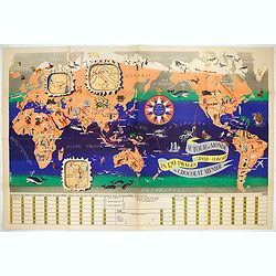
Le Tour du Monde en 120 Images Grand Concours du Chocolat Menier.
This highly unusual and rather novel pictorial map of the world was created by J.B. Jannot and published by Agence Française de Propagande as a promotional item for Menie...
Date: Paris, 1956
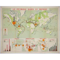
Le pétrole dans le monde.
FIRST EDITION: Poster published by the Union of Union Chambers of the Petroleum Industry. Large world map showing the oil fields in the world: United States, U.S.S.R., Ve...
Date: Paris, Imp. Lafayette. 1956

AIR France - Le plus grand réseau du monde.
Created in 1959 by the artist Lucien Boucher, showing all of the DC-7 Air France Routes. The Blue Pink Poster is one of a series of eight posters commissioned by Air Fran...
Date: Imprimerie Perceval, Paris, 1959
![[TAI travel poster]](/uploads/cache/44304-250x250.jpg)
[TAI travel poster]
A whimsical travel poster for "Transport Aeriens Intercontinentaux" (TAI), published in Paris in 1960, by Luc-Marie Bayle (1914-2000). The poster depicts a twin...
Date: Paris, 1960
![[TAI travel poster]](/uploads/cache/44893-250x250.jpg)
[TAI travel poster]
A whimsical travel poster for "Transport Aeriens Intercontinentaux" (TAI), published in Paris in 1960, by Luc-Marie Bayle (1914-2000). The poster depicts a twin...
- $700 / ≈ €612
Date: Paris, 1960
![[TAI travel poster]](/uploads/cache/44894-250x250.jpg)
[TAI travel poster]
A whimsical travel poster for "Transport Aeriens Intercontinentaux" (TAI), published in Paris in 1960, design by François Lesourt (Périgueux, 1913 - 1997). The ...
Date: Paris, Hubert Baille & Cie Paris, 1960
