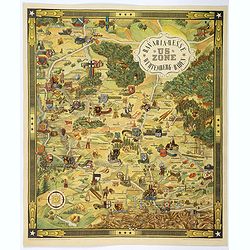
US ZONE. Bavaria, Hesse, Wurtemberg, Baden.
An unusual decorative pictorial map, from the years immediately following World War II, depicting the American Zone of Occupation in southern Germany. It portrays rural ...
- $450 / ≈ €393
Date: Munich, 1940
![Map of the Occupied Areas. Carte des Zones d'Occupation. Der Besatzungs-Zonen mit Neuen Postleitgebieten. Karta Okkupacionnych Zon [in Cyrillic.]](/uploads/cache/42060-250x250.jpg)
Map of the Occupied Areas. Carte des Zones d'Occupation. Der Besatzungs-Zonen mit Neuen Postleitgebieten. Karta Okkupacionnych Zon [in Cyrillic.]
A poster map of Germany and Austria showing the Allied occupation zones as agreed at the Potsdam Conference after the end of the Second World War, with an inset detail of...
$350 / ≈ €305
Date: Frankfurt-am-Maine: Atlanta-Service, 1946
