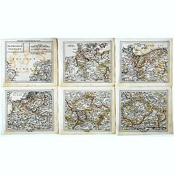
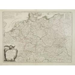
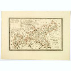
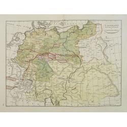
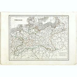
The Empire of Germany.
Uncommon miniature map in six sheets of the Empire of Germany, engraved by Thomas Kitching for "A New General and Universal Atlas Containing Forty five Maps by Andre...
- $75 / ≈ €65
Date: London, 1761-1763
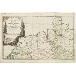
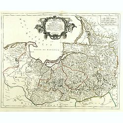
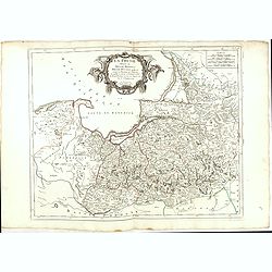
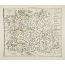
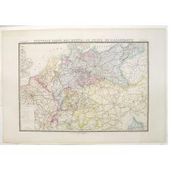
Nouvelle carte géographique des postes et autres routes d'Allemagne. . .
Map showing the northern provinces in Germany and part of the Netherlands. Decorative title cartouche in the upper left corner. A so-called post road maps.
- $80 / ≈ €69
Date: Paris, 1766
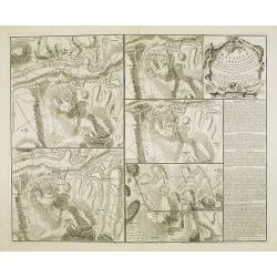
Bataille du Johansberg Gagnée par son Altesse Sérénissime Monseigneur le Prince de Condé . . . Le 30 Aoust 1762 . . .
Five detailed military battle-plans showing the four stages in the siege of Johansburg and the battle plan around Grüningen published by Jean de Beaurain (1696–1771) ....
- $150 / ≈ €130
Date: Paris, 1766
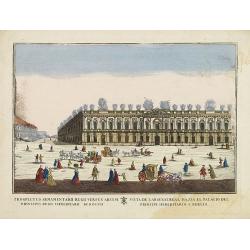
(Berlin) Prospectus Armamentarii regnii versus arcem principis regis haereditarii Berolini.
A square in Berlin. In the eighteenth and nineteenth centuries there were many popular speciality establishments in Paris, Augsburg and London which produced optical view...
- $200 / ≈ €173
Date: Italy, 1770
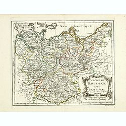
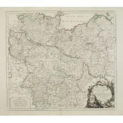
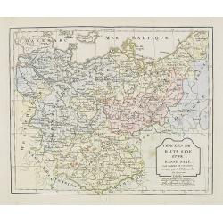
Cercles de Haute-Saxe et de Basse-Saxe.
Early edition of this fine map of the duchies of Saxony (upper & lower), including part of present-day Poland. Published in "Atlas Portatif de Vaugondy".Cha...
- $75 / ≈ €65
Date: Paris, ca.1770
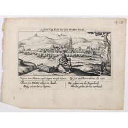
Sontra.
A panoramic view of the city Sontra in Hessen . With motto "ein klug Kind das sein Mutter kennt". On the foreground, a woman with two children and a crypt. With...
- $50 / ≈ €43
Date: Frankfurt, 1623-1778
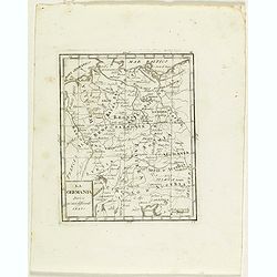
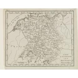
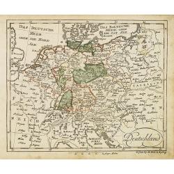
La Germania divisa ne' suoi differenti stati
Rare map of Germany, from "Atlante Novissimo ad uso Dei Giovani Studiosi Contenuto In Carte XXVII.", published by Giovanni Zempel in Rome, ca. 1780.The map is b...
- $25 / ≈ €22
Date: Rome, 1780
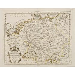
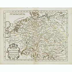
Carte de l'Empire d'Allemagne Divisé par Cercles..
Rare map of Germany and the Low Countries prepared by J.B.Nolin and published by Monhare for his Atlas Général a l'usage des colleges et maisons d'education.Louis Josep...
- $100 / ≈ €86
Date: Paris, 1783
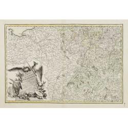
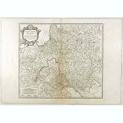
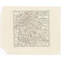
Carte de L'Empire D'Alemagne avec les Etats de Bohême..
Attractive map centered on the southwestern part of Germany, including Switzerland, Luxembourg and part of Austria.Decorative title cartouche with wine grapes, musical in...
Date: Paris ca 1783
Carte de l'Empire d' Allemagne . . .
Scarce map of Germany prepared by de la Fosse and published by L.J. Mondhare for his Atlas Général a l'usage des colleges et maisons d'education.. Louis Joseph Mondhare...
- $50 / ≈ €43
Date: Paris, 1783
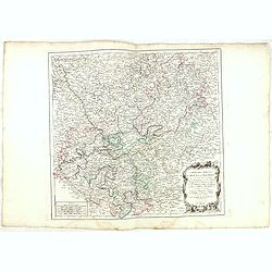
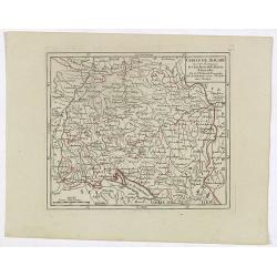
Cercle de Haute Saxe.
Finely and crisply engraved map of Germany, centered on Leipzig .Venetian edition of Giles Didier Robert De Vaugondy's map from Atlas Universel printed in 1776-84.Ornamen...
Date: Venice, 1776 - 1784
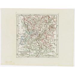
Cercle de Basse Saxe où sont distingués les états de ... et des évêchés d'Hildesheim et d'Halberstadt par le Sr. Robert.
Finely and crisply engraved map of northern part of Germany, including the river Elbe, with Hamburg until Potsdam. In the upper right the Baltic coast including Wismar, R...
- $150 / ≈ €130
Date: Venice, 1776 - 1784
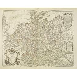
L'Empire d'Allemagne..
Detailed map encompassing Germany, the Netherlands, Belgium, Austria, and part of Poland.Venetian edition of the map by Bellin, to whom Santini gives credit in the cartou...
- $100 / ≈ €86
Date: Venice, 1776 - 1784

Campagne du Roi de Prusse de 1778 à 1779.
The book is illustrated with a two-sheet folding map "Carte d'une partie du Royaume de Bohême et de la Moravie ainsi que d'une partie de la Silésie". Prepared...
Date: Geneva, Paris, Mérigot le jeune, 1784
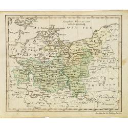
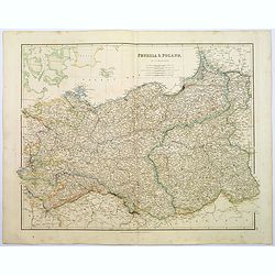
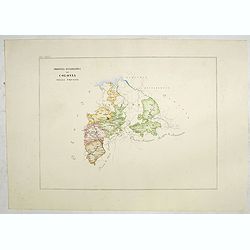
La Prusse divisée en Prusse Royale et Prusse Ducale.
The map extends from Memem, Danzig and Rosienne in the North to Novigrod in the southeast and Thorn on the Wessel in the southwest. Shows the Gulf of Danzig and part of P...
- $300 / ≈ €259
Date: Venice, 1776 - 1784
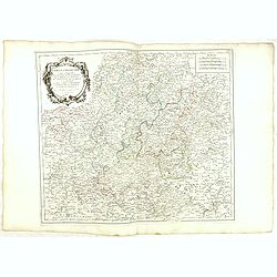
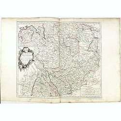
Carte des Cercle du Haut et du Bas Rhin.. avec leurs enclaves.
Finely and crisply engraved map of Germany showing the river Rhine, including Duisburg, Spire, Mannheim, etc.With ornamental title cartouche and noteworthy topographical ...
- $75 / ≈ €65
Date: Venice, 1776 - 1784
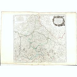
Cercle de Franconie.. Reineck d' Erpach.
Finely and crisply engraved map, centered on Schweinfurt, Bamberg and Nuremberg.With ornamental title cartouche and noteworthy topographical detail.The map was prepared b...
- $100 / ≈ €86
Date: Venice, 1776 - 1784
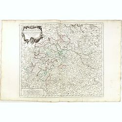
Le cercle De Baviere.. et la prevoté de Berchtolsgaden.
Finely and crisply engraved map centered on Regensburg, including some great skiing resort areas of Austria and part of Germany, centered on Passau, Ingollstat, Salzburg....
- $100 / ≈ €86
Date: Venice, 1776 - 1784
Cercle de Haute Saxe.
Finely and crisply engraved map of Germany, centered on Leipzig. From Atlas Universel printed in 1776-84.With ornamental title cartouche and noteworthy topographical deta...
- $75 / ≈ €65
Date: Venice, 1776 - 1784
Cercle de Basse Saxe où sont distingués les états de ... et des évêchés d'Hildesheim et d'Halberstadt par le Sr. Robert.
Finely and crisply engraved map of northern part of Germany, including the river Elbe, with Hamburg until Potsdam. In the upper right the Baltic coast including Wismar, R...
- $100 / ≈ €86
Date: Venice, 1776 - 1784
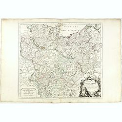
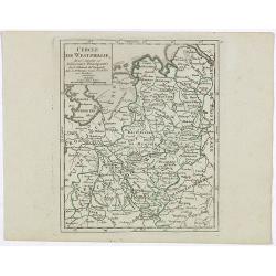
Cercle de Westphalie divisé en tous ses Etats et Souverainetés.
Finely and crisply engraved map of central Germany, including the river Rhine from Deventer till Bonn, with Dusseldorf. In upper left , inset of the area of Emden until O...
- $100 / ≈ €86
Date: Venice, 1776 - 1784
La Prusse divisée en Prusse Royale et Prusse Ducale.
The map extends from Memem, Danzig and Rosienne in the North to Novigrod in the southeast and Thorn on the Wessel in the southwest. Shows the Gulf of Danzig and part of P...
Date: Venice, 1776 - 1784

Carte De La Prusse Occidentale ou sont tracees les Provinces cedees Par la Pologne au Roi De Prusse . . . 1775
Finely and crisply engraved map of Western Prussia, now part of Poland on the Baltic Sea, including the Bay of Danzig. With ornamental title cartouche and noteworthy topo...
Date: Venice, 1776 - 1784
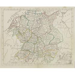
L'Allemagne dressée sur les observations. . .
Map of Germany, Low Countries, Poland, Switzerland, Northern Italy. Prepared by G.De L'Isle after observations by Kepler and Tycho Brahe.Engraved by Jean Batiste Liébaux...
Date: Paris, 1788

Tableau des guerres de Frédéric le Grand: ou plans figurés de vingt-six batailles rangées, ou combats essentiels donnés dans les trois guerres de Silésie. . .
The book includes a large folded map "Tableaux des Guerres de Frédéric le Grand", showing a map of Prussia, with present-day Poland and Eastern Germany surrou...
Date: Potzdam, Strasbourg, Paris, 1788
Le Royaume De Pologne, divise selon les Partages faits en 1772, 1793 et 1795, etnre la Russie, la Prusse et l'Autriche . . .
The uncommon later edition of this detailed map of Poland, showing the lands lost to Russia, Prussia and Austria in 1772, 1793 and 1795. with a color key added underneath...
Date: Paris, ca. 1796
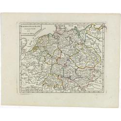
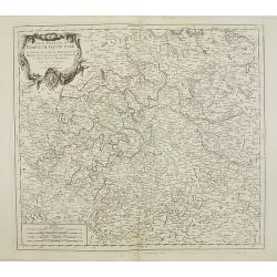
Empire d'Allemagne divisé par Cercles et Cours du Rhin.
Small detailed map of Germany, the Low Countries, Switzerland, Austria, Czechoslovakia and part of Poland.From Atlas Portatif Universel, by Robert de Vaugondy. Edited by ...
- $40 / ≈ €35
Date: Paris, 1799
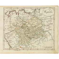
Cercle de Westphalie, divisé suivant ses différentes Principautés.
Small detailed map of the north western part of Germany, centred on Münster. From Atlas Portatif Universel, by Robert de Vaugondy.Edited by : "Au dépôt de Géogra...
- $30 / ≈ €26
Date: Paris, 1799
Cercle de Souabe où sont distingués les Enclaves de la Maison d'Autriche.
Small detailed map showing the state Baden-Württemberg, part of Bavaria and part of Austria.From Atlas Portatif Universel, by Robert de Vaugondy. Edited by : "Au d�...
- $70 / ≈ €61
Date: Paris, 1799
VII. Cours du Rhin où sont les environs de Philisbourg, Spire Landaw &c.
Small detailed map illustrating the stretch of the Rhine which flows between Germersheim and Speyer.From Atlas Portatif Universel, by Robert de Vaugondy. Edited by : &quo...
- $25 / ≈ €22
Date: Paris, 1799
Cercle des quatre Electeurs.
Small detailed map of part of western Germany, centered on Frankfurt. From Atlas Portatif Universel, by Robert de Vaugondy.Edited by : "Au dépôt de Géographie, Ru...
Date: Paris, 1799
Cercle de Baviere où se trouvent le Palatinat de Baviere et l'Archev. De Saltzbourg.
Small detailed map of the southeastern part of Bavaria, including part of Austria. From Atlas Portatif Universel, by Robert de Vaugondy.Edited by : "Au dépôt de G�...
Date: Paris, 1799
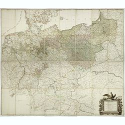
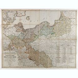
General Karte von den saemtlichen Kšnig. Preussischen Staaten welche zugleich als POSTKARTE durch die Länder der Preussischen Monarchie und durch ganz Deutschland diendt. . .
Large wall map (1,25 x 1,38 meters) of Prussia and present-day Poland, prepared by D.F. Sotzmann and published by Königl. Preuss. Academie Kunst und Buchhandlung.A detai...
- $1500 / ≈ €1297
Date: Berlin, 1802
Cercle de Haute Saxe et de Basse Saxe. . .
Map of the duchies of Saxony (upper & lower). By C. F. Delamarche, successor of Robert de Vaugondy, Geographer.
- $50 / ≈ €43
Date: Paris, 1794 - 1806
L'Allemagne . . .
Map of Germany, from Atlas moderne portatif composé de vingt-huit cartes sur toutes les parties du globe terrestre .. A l'usage des Colléges, des Pensions & des Mai...
- $50 / ≈ €43
Date: Paris, Prudhomme, Levrault, Debray, 1806
Carte d'Allemagne et de la Republique Helvetique.
Map of central Europe centered on Germany, extending southwards and eastwards to include Poland, the Czech Republic, Austria, Switzerland, Slovenia and part of Italy.From...
Date: Paris, Prudhomme, Levrault, Debray, 1806

Femme d'Ausbourg.
Originally hand-colored mezzotint from 'Costumes civils actuels de tous les peuples connus'. After Jacques Grasset de Saint-Sauveur. As an etcher, drawer and writer, Gras...
- $50 / ≈ €43
Date: Paris,1806
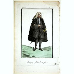
Homme d'Ausbourg.
Originally hand-colored mezzotint from 'Costumes civils actuels de tous les peuples connus'. After Jacques Grasset de Saint-Sauveur. As an etcher, drawer and writer, Gras...
- $50 / ≈ €43
Date: Paris,1806
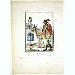
Homme & Femme de la Baviere.
Originally hand-colored mezzotint from 'Costumes civils actuels de tous les peuples connus'. Engraved by Félix Mixelle after Jacques Grasset de Saint-Sauveur.As an etche...
- $50 / ≈ €43
Date: Paris,1806
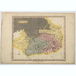
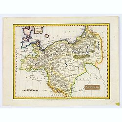
Prussia.
A general map of Prussia, engraved by J.Wallis for Oddy's General Atlas in full original color. Prussia was a historically prominent German state that originated in 1525 ...
Date: London, 1811
Deutschland (with Poland)
Nice small map of Germany by Johannes Walch in his rare Allgemeiner Atlas Nach den bewährsten Hülfsmitteln und astronomischen Ortsbestimungen…, edition of 1812.Johann...
- $75 / ≈ €65
Date: Augsburg, 1812
Westphalen.
Nice small map of Westphalia in Germany by Johannes Walch in his rare Allgemeiner Atlas Nach den bewährsten Hülfsmitteln und astronomischen Ortsbestimungen…, edition ...
- $50 / ≈ €43
Date: Augsburg, 1812
Brandenburg und Pommern.
Nice small map of Brandenburg and Pommeren, centered on Berlin by Johannes Walch in his rare Allgemeiner Atlas Nach den bewährsten Hülfsmitteln und astronomischen Ortsb...
- $75 / ≈ €65
Date: Augsburg, 1812
General Charte der Preussischen Monarchie in zwey Blattern. . .
Uncommon and detailed map of Kingdom of Prussia with present day Poland and Germany. Uncommon map engraved by Ludwig Hess and published in Weimar by Fr. Wilhelm Streit.
- $1000 / ≈ €864
Date: Weimar, 1812
Prussia.
A small, early nineteenth-century map of Prussia. The cities of Berlin, Dantzick and Konigsberg are highlighted in red. Map extent is from Magdeburg in the west to Poznan...
Date: Liverpool, ca 1814
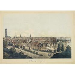
Hamburg im Jahre 1813
Decorative lithographed view of Hamburg. The print is issued in colors but finished by hand.
- $150 / ≈ €130
Date: Germany,1820
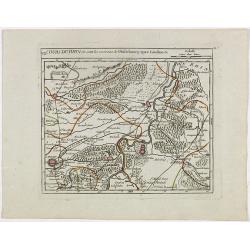
![[No tittle] Partie de la Prusse.](/uploads/cache/30632-250x250.jpg)
[No tittle] Partie de la Prusse.
Detailed map of the south of Baltic Sea. With a paper printed label of the Paris map seller Jean Goujon who was active from 1793-1826. The label carries the address of Ru...
- $90 / ≈ €78
Date: Paris, c. 1820
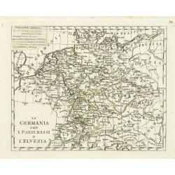
La germania con i Paesibassi e l'elvezia.
Charming map of Germany, The Netherlands, Switzerland and part of Poland from the rare atlas Atlante Tascabile o sia Serie di Num. XXI Cartine Geografiche nelle quali si ...
- $80 / ≈ €69
Date: Rome, 1823
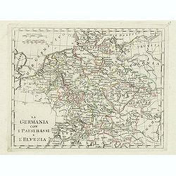
La germania con i paesi bassi e l'elvezia.
Charming map of Germany, Netherlands, Switzerland, Austria from the rare atlas Atlante Tascabile o sia Serie di Num. XXI Cartine Geografiche nelle quali si rappresenta in...
- $65 / ≈ €56
Date: Rome, 1823
Carte Generale du Royaume de Prusse. . .
A nice French map, typical of the period, of the Kingdom of Prussia, by Vivien, from the "Atlas Universel Pour servir a l'Etude De la Geographie et de l'Histoire Anc...
Date: Paris, 1824
Allemagne . . .
Detailed map of Germany and Austria, prepared by A. H. Basset, rue Saint-Jacques, no. 64, Paris and published in Atlas classique et Universel de Géographie . . . .The en...
- $80 / ≈ €69
Date: Paris, A.H. Basset, 1828
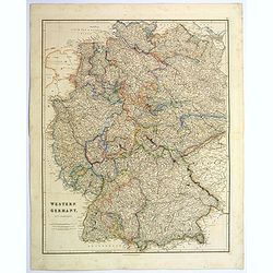
Western Germany.
A lovely, large steel engraved map of Western Germany. Some of the states engraved are: Holstein, Hannover, Mecklenburg, Saxony, Bavaria, Württemberg and Nassau. An extr...
Date: London, 1839
Prussia & Poland.
A glorious, large steel engraved map of Prussia and Poland. Some of the states covered are: Saxony, Pomerania, Posen, Brandenburg, Western & Eastern Prussia and the K...
Date: London, 1839
L'Alemagna . . .
A rare double-page map of Germany and Poland. Prepared by Las Casas and engraved by G.V.Pasquali for l'Atlante Storico, Letterario, Biografico, Archeologico. . . with at...
- $50 / ≈ €43
Date: Venice, 1840
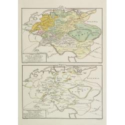
I dieci circoli Della Germania . . . / Permute e Secolarizzazioni Nella Germania . . .
Two rare maps of Germany: Top map: 160 x 235mm. Bottom map: 160 x 235mm.Prepared by Las Casas for l'Atlante Storico, Letterario, Biografico, Archeologico. . . with attri...
- $30 / ≈ €26
Date: Venice, 1840
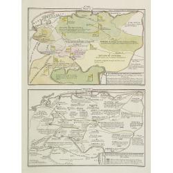
La Germania, suoi ducati e dependenze . . . /Origine e derivazione de principali stati . . .
Two rare maps of ancient Germany: Top map: 160 x 235mm. Bottom map: 160 x 235mm.Prepared by Las Casas for l'Atlante Storico, Letterario, Biografico, Archeologico. . . wi...
- $25 / ≈ €22
Date: Venice, 1840
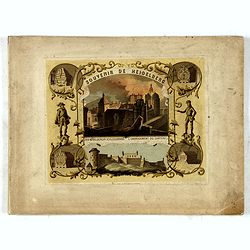
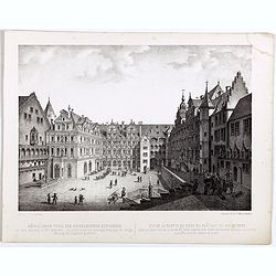
(Title page) Souvenir de Heidelberg.
Cover for a souvenir album with chromolithographed design and entitled: Souvenir de Heidelberg prepared by Louis Charles François. He emigrated with his family in May 17...
- $50 / ≈ €43
Date: Graimberg, Heidelberg, ca. 1840
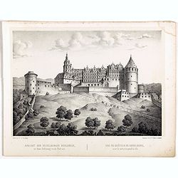
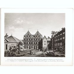
Ansicht der Heidelberger Schlosses. . .
Early lithograph published by Louis Charles François de Graimberg-Belleau. Lithographed by C.F Müller.French artist. Son of Gilles-François Belleau Graimberg. Louis Ch...
Date: Graimberg, Heidelberg, ca. 1840

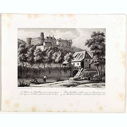
Vue de la porte Charles. . . Ansicht ded Karlthors . . .
Early aquatint after Louis Charles François de Graimberg-Belleau. Engraved by J.J Tanner.French artist. Son of Gilles-François Belleau Graimberg. Louis Charles Françoi...
Date: Graimberg, Heidelberg, ca. 1840
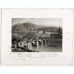
Vue du pont de Heidelberg. Ansicht der Brücke in Heidelberg.
Early aquatint after Louis Charles François de Graimberg-Belleau. Engraved by J.J Tanner.French artist. Son of Gilles-François Belleau Graimberg. Louis Charles Françoi...
Date: Graimberg, Heidelberg, ca. 1840
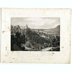
Vue de Heidelberg . . . Ansicht von Heidelberg . . .
Early aquatint after Louis Charles François de Graimberg-Belleau. Lithographed by J.J Tanner.French artist. Son of Gilles-François Belleau Graimberg. Louis Charles Fran...
Date: Graimberg, Heidelberg, ca. 1840
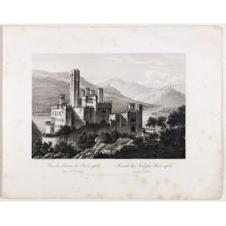
Vue du château de Stolzenfels . . . Ansicht des Schlofses Stolzenfels . . .
Early aquatint after Louis Charles François de Graimberg-Belleau. Lithographed by J.J Tanner.French artist. Son of Gilles-François Belleau Graimberg. Louis Charles Fran...
Date: Graimberg, Heidelberg, ca. 1840
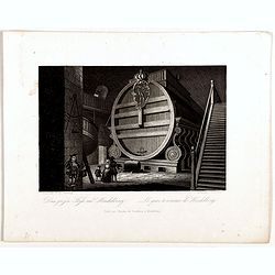
Das grofse Fafs au Heidelberg . Le gros tonneau de Heidelberg.
Engraving after Louis Charles François de Graimberg-Belleau. Engraved by J.J Tanner.French artist. Son of Gilles-François Belleau Graimberg. Louis Charles François emi...
Date: Graimberg, Heidelberg, ca. 1840
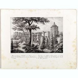
Nördlicher Theil des Heidelberg schlosses. Vue de la partie du nord du château de Heidelberg.
Early lithographs after Louis Charles François de Graimberg-Belleau. Lithographed by C.F Müller.French artist. Son of Gilles-François Belleau Graimberg. Louis Charles ...
Date: Graimberg, Heidelberg, ca. 1840
Nördlicher Theil des Heidelberger schlosses. . . Façade nord du château de Heidelberg . . .
Early aquatint after Louis Charles François de Graimberg-Belleau. Engraved by Hibon and F. Salathé.French artist. Son of Gilles-François Belleau Graimberg. Louis Charl...
Date: Graimberg, Heidelberg, ca. 1840
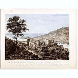
Vue du château et de la ville de Heidelberg . . . Ansicht des schlosses und der stadt Heidelberger . . .
Engraving after Louis Charles François de Graimberg-Belleau. Lithographed by Ch. Haldennvang.French artist. Son of Gilles-François Belleau Graimberg. Louis Charles Fran...
Date: Graimberg, Heidelberg, ca. 1840

Vue de la ville et du château de Heidelberg . . . Ansicht der stadt und des schlosses Heidelberger . . .
Engraving after Louis Charles François de Graimberg-Belleau. Engraved by Ch. Haldennvang.French artist. Son of Gilles-François Belleau Graimberg. Louis Charles Françoi...
Date: Graimberg, Heidelberg, ca. 1840

Vue du château de Heidelberg . . . Ansicht des Heidelberger schlosses . . .
Engraving after Louis Charles François de Graimberg-Belleau. Engraved by Charles Haldenwang.French artist. Son of Gilles-François Belleau Graimberg. Louis Charles Fran�...
Date: Graimberg, Heidelberg, ca. 1840
Ruines des batimens d' Adolphe et de Robert J au châteaude Heidelberg . . . Die ruinen des Adolfs und Rupruhtsbaues J auf dem Heidelberg . . .
Early lithography after Louis Charles François de Graimberg-Belleau. Lithographed by L. Faure.French artist. Son of Gilles-François Belleau Graimberg. Louis Charles Fra...
Date: Graimberg, Heidelberg, ca. 1840
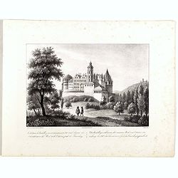
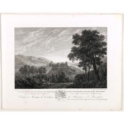
Le châteaude Heidelberg au commencemment de XVIIe siecle. . . Das Heidelberg schlosse von den acusseren . . .
Early lithography after Merian. Lithographed by L. Faure.French artist. Son of Gilles-François Belleau Graimberg. Louis Charles François emigrated with his family in Ma...
Date: Graimberg, Heidelberg, ca. 1840
Le châteaude Heidelberg et ses environs . . . Das Heidelberg schlosse mit seinen umgebungen . . .
Early lithographs after Louis Charles François de Graimberg-Belleau. Lithographed by L. Faure.French artist. Son of Gilles-François Belleau Graimberg. Louis Charles Fra...
Date: Graimberg, Heidelberg, ca. 1840
Ansicht des Heidelberger schlosses . . . Vue du château de Heidelberg . . .
Early lithographs after Louis Charles François de Graimberg-Belleau. Lithographed by Salathé.French artist. Son of Gilles-François Belleau Graimberg. Louis Charles Fra...
Date: Graimberg, Heidelberg, ca. 1840
Prusse.
Detailed map of Prussia, prepared by Charles V. Monin (fl.1830-1880) a French cartographer of Caen and Paris. Published in Atlas Universel de Géographie Ancienne &c ...
- $40 / ≈ €35
Date: Paris, 1845

(Lübeck) Lvbeca vrbs. imperialis libera. civitatvm. Wandalicarvm. . . .
Impressive, more than 3 meters wide panoramic town view after a woodblock engraving from Elias Diebel, initially made in 1552. Of this original woodblock, Bachmann mentio...
Date: Germany, c. 1855
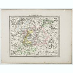
Le Vie Ferrate e le Strade Postali della Germania centrale e meridionale . . .
Uncommon map of Germany and part of France and Switzerland prepared by Francesco Costantino Marmocchi. Above the map "Geografia Commerciale". From "Il Glob...
- $25 / ≈ €22
Date: Genova, Paolo Rivara fu Giacomo, 1858
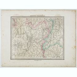
Le Vie Ferrate e le Strade Postali della Germania orientale . . .
Uncommon map of Germany and part of Poland, Hungary and Italy prepared by Francesco Costantino Marmocchi. Above the map "Geografia Commerciale". From "Il G...
- $25 / ≈ €22
Date: Genova, Paolo Rivara fu Giacomo, 1858
Provincia ecclesiastica di Colonia nella Prussia (Tav LXXXI)
This large-format south Germany Cologne map is finely engraved and beautifully colored and was prepared by Girolamo Petri, a lawyer who served as a senior official within...
- $250 / ≈ €216
Date: Rome, 1858
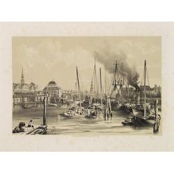
Hambourg.
Uncommon and decorative lithography of the harbor of Hamburg, published by Carl Johan Billmark and printed by Lemercier in Paris, 55 rue de Seine, the leading firm in Eur...
Date: Paris, c.1859
Nouvelle carte des routes de poste de l'Allemagne.
Large post road maps map of Germany, Poland, Austria, Franc, Switzerland, Austria and the Low Countries published by A. Logerot and engraved by C.Dyonnet.The mapsmakes di...
- $350 / ≈ €303
Date: Paris, A. Logerot, c.1867
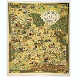
US ZONE. Bavaria, Hesse, Wurtemberg, Baden.
An unusual decorative pictorial map, from the years immediately following World War II, depicting the American Zone of Occupation in southern Germany. It portrays rural ...
Date: Munich, 1940
