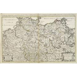
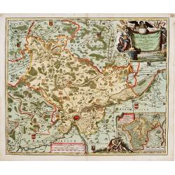
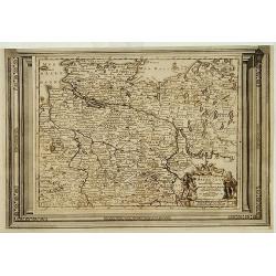
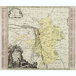
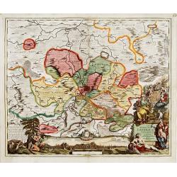
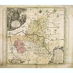
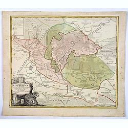
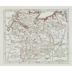
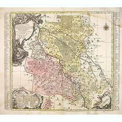
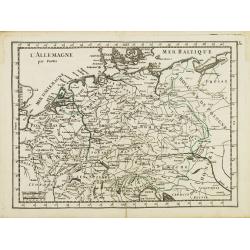
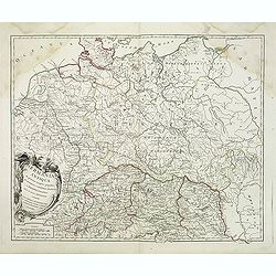
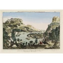
Le cercle de la Basse Saxe subdivisé en touts les estats et principautés qui le composant . . .
It is a very large map centered on the river Elbe and following the coastlines of the Baltic Sea up to the Polish border. The map is fully and richly engraved. Large and ...
- $200 / ≈ €176
Date: Amsterdam, c.1705
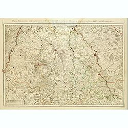
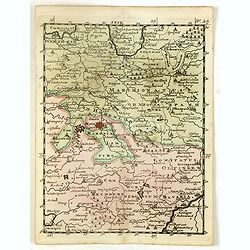
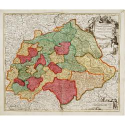
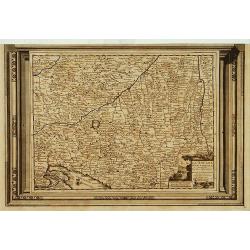
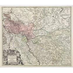
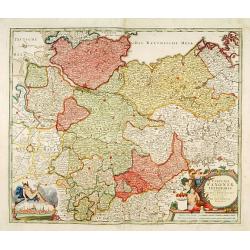
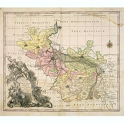
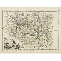
Partie Méridionale de l'Archevesché et Eslectorat de Cologne. . .
Fine map of the Westphalia, the area in-between the Rivers Maas and Rhine.
- $50 / ≈ €44
Date: Paris, 1707
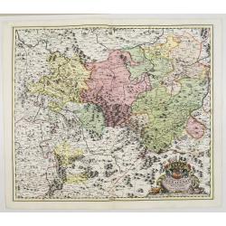
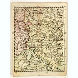
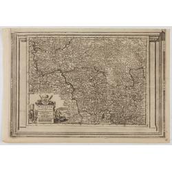
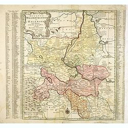
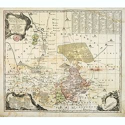
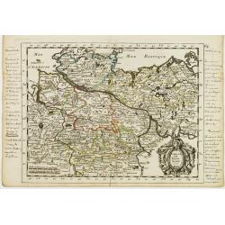
Principatus Isenacensis cum adjacentibus. . .
Detailed map centered on Gotha and Erfurt. Lower right splendid title cartouche.The map is painted in strong colors. Clearly from an show-piece atlas produced for a wealt...
- $200 / ≈ €176
Date: Nurenberg, 1710

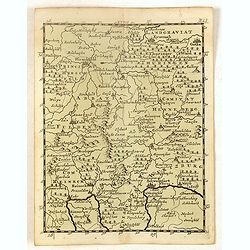
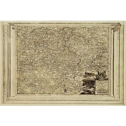
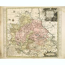
Landgraviatus Alsatiae tam superioris..
Alsace, in the far north-eastern corner of France, stands out from other French wine regions thanks to its strong Franco-Germanic influences. Alsace is the only French wi...
Date: Nurenberg, 1710
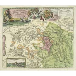
Geographica descriptio Montani cujusdam districtus in ..
Detailed map including the towns of Thurnau, Bayreuth, Culmbach, etc. With fine panoramic view of Thurnau. Upper left and right splendid title cartouches.The map is paint...
Date: Nurenberg, 1710
(Ochfenfurt, Hall, Bavaria, etc.)
Rare miniature map of Bavaria including the towns of Ochfenfurt, Hall, etc. From "Le theatre De Bellone, Contenant 48. nouvelles Cartes Geographiques, Des Païs-Bas ...
- $60 / ≈ €53
Date: Amsterdam, 1710
(Hildesheim, Munden, Steinbrugge, Grubenhagen, etc.)
Rare miniature map including the towns of Hildesheim, Munden, Steinbrugge, Grubenhagen, etc. From "Le theatre De Bellone, Contenant 48. nouvelles Cartes Geographique...
- $60 / ≈ €53
Date: Amsterdam, 1710
(Schweinfurt, Reineck, Hirschfeld, etc.)
Rare miniature map including the towns of Schweinfurt, Reineck, Hirschfeld, etc. From "Le theatre De Bellone, Contenant 48. nouvelles Cartes Geographiques, Des Païs...
- $60 / ≈ €53
Date: Amsterdam, 1710
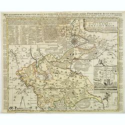
Accurate geographische delineation der in dem Meisnichen creisse des chufurstenthums sachsen liegenden dioeces oder des ammtes grossen hayn
Very detailed map prepared by Adam Frederic Zürner (1680-1742). Surrounded with legends and decorated in the lower right corner with a plan of a royal campement. The tow...
- $90 / ≈ €79
Date: Amsterdam, 1711
Le Duche de Lunebourg. . .
A lovely, detailed map by Pierre Van der AA of the northern German region of Luneburg in Lower Saxony, roughly situated between the Elber and the Aller Rivers. Luneburg i...
Date: Leiden, 1713
Carte du cours du Rhin dpuis le fort de Schengen jusqu'à Lauterbourg. . .
Beautiful manuscript map of the region around Rastatt and the siege of 1714 signed with the French emperor Charles VI of Habsburg. In top with a small extension of the ma...
Date: Germany, France, c. 1714
L'Empire D'Allemagne Divisé en ses dix Cercles et Autres Estats..
Map centered on Germany, including Switzerland, Austria, part of France, Northern Italy and Eastern Europe. With title cartouche and a panel in the lower left corner list...
- $60 / ≈ €53
Date: Paris 1719
L'Empire D'Allemagne Divisé en ses dix Cercles et Autres Estats. . .
Map centered on Germany, including Poland, Switzerland, Austria, part of France, Northern Italy and Eastern Europe. With title cartouche and a panel in the lower left cor...
- $80 / ≈ €70
Date: Paris, 1719
Nova et accurata Territorii Ulmensis cum dominio Wainensi..
"Showing the area of Ulm. In the lower part, an inset map of the property"zu Wein". Upper right splendid title cartouche.The map is painted in an intense a...
Date: Nurenberg 1720
Saxoniae Superioris
Impressive title cartouche with miniature panoramic view of Leipzig, coat of arms, putti and Mercury.Johann Baptist Homann born in Kammlach (1663). He was engraver, map-s...
- $150 / ≈ €132
Date: Augsburg, 1720
![Mayence Mentz en allemand .. [Metz]](/uploads/cache/13109-250x250.jpg)
Mayence Mentz en allemand .. [Metz]
A very RARE panoramic view of the city of Metz, including a numbered legend in the lower corners. The plate is numbered in red pencil in the upper right corner.Engraved b...
- $200 / ≈ €176
Date: Paris 1690-1720
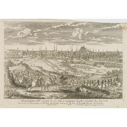
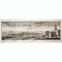
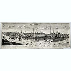
Nuremberg.
A very RARE panoramic view of the city of Nuremberg. The plate is numbered in red pencil in the upper right corner.Engraved by Pierre Aveline (Paris, c.1656 - 23 May 1722...
- $200 / ≈ €176
Date: Paris, 1690-1720
Ausbourg Ville Impériale d'Allemagne dans la Suabe.
A very RARE panoramic of the city of Augsburg. The plate is numbered in red pencil in the upper right corner.Engraved by Pierre Aveline (Paris, c.1656 - 23 May 1722). He ...
- $250 / ≈ €219
Date: Paris, 1690-1720
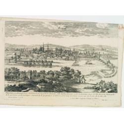
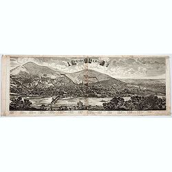
Treves en Allemend Trier.
A very RARE panoramic view of the city of Trier. The plate is numbered in red pencil in the upper right corner.Engraved by Pierre Aveline (Paris, c.1656 - 23 May 1722). H...
- $200 / ≈ €176
Date: Paris, 1690-1720
Philisbourg.
A very RARE panoramic view of the city of Philipsburg, including a numbered legend in both lower corners. The plate is numbered in black pencil in the upper right corner....
- $150 / ≈ €132
Date: Paris c.1720
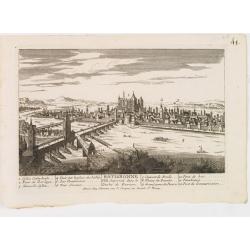
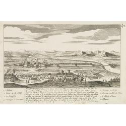
Ratisbonne.
A very RARE panoramic town view of the city of Ratisbonne, including a numbered legend in both lower corners. The plate is numbered in black pencil in the upper right cor...
- $200 / ≈ €176
Date: Paris c.1720
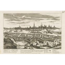
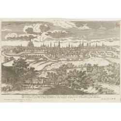
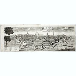
Breme.
A rare panoramic view of the city of Bremen, including a numbered legend in both lower corners.Published by the brothers Chéreau, active in Paris at rue st.Jacques au Gr...
- $200 / ≈ €176
Date: Paris c.1720
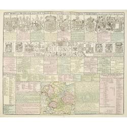
Kort Begryp van Duytsland, de drie Ryx Collegien in hunne Wapens en Zittingen. Kreits Verelingen en Aantekenigen door C. Specht't Utrectht.
Second state of this decorative table of family escutcheons, crests and coats of arms, for various German and Dutch princes and nobles of the 16th, 17th and 18th Centurie...
Date: Amsterdam, 1720
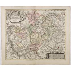
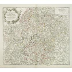
Nassovia Principatus Cum omnibus ei pertinentibus Comitatibus Dominiis ac Praefecturis ut et Confiniis intra Lahnun, Rhenum, et Moenum Flumina, ad situm verum exacte delineatus a Joh. Jac. Stetter. U.J.L. Idstenio-Nassovio . . .
Decorative map of the area between the rivers Rhine and Meuse, including Mainz, Koblenz, Frankfurt, Saarbrucken, etc.Includes an elaborate cartouche and coat of arms.The ...
- $150 / ≈ €132
Date: Amsterdam, 1720

Norimberga.
A spectacular panoramic town-view of Nuremberg, with legends numbered from 1-39 in German. With the title in a banderol.After a design by Friedrich Bernhard Werner (1690...
Date: Augsburg, ca. 1720
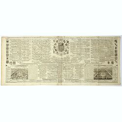
Carte genealogique de la famille Royale de Brunswick . .
A very detailed composite sheet with a genealogical table of the German royal families of Brunswick, Luneburg and Hanover, with descriptive French textZacharie Chatelain ...
- $50 / ≈ €44
Date: Amsterdam, ca. 1720
Le Duché de Lunebourg, suivant les nouvelles observations?
Uncommon edition of this map of a province of Germany. With decorative title cartouche upper right corner.This example is unusual in having the additional separately engr...
- $80 / ≈ €70
Date: Amsterdam, 1728
Cercle de la Basse Saxe, suivant les nouvelles observations..
Uncommon edition of this map of a province of Germany, including Hamburg, Bremen, etc. With decorative title cartouche lower right corner.This example is unusual in havin...
- $90 / ≈ €79
Date: Amsterdam 1728
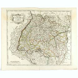
La Souabe meridionale, suivant les nouvelles observations..
Uncommon edition of this map of Southern Germany. With decorative title cartouche lower right corner.This example is unusual in having the additional separately engraved ...
- $90 / ≈ €79
Date: Amsterdam 1728
L'Archeveché de Mayence, suivant les nouvelles observations..
With decorative title cartouche lower left corner. Including river Rhine. This example is unusual in having the additional separately engraved decorative framework border...
- $100 / ≈ €88
Date: Amsterdam, 1728
Landgraviat de Hesse, suivant les nouvelles observations..
With decorative title cartouche lower right corner.This example is unusual in having the additional separately engraved decorative framework border around the map, the re...
- $90 / ≈ €79
Date: Amsterdam 1728
Nova et Accurata Ducatus Cliviae et Comitatus Marchiae.
With an elaborate -uncolored- title cartouche.
Date: Augsburg, 1728
Heidelberg.
A spectacular panoramic view of Heidelberg, with legends numbered from 1-72 in German. With the title in a banderol.After a design by Friedrich Bernhard Werner (1690-1776...
- $1500 / ≈ €1316
Date: Augsburg, 1729
Bamberg in Francken.
A spectacular panoramic view of Bamberg, with legends numbered from 1-24 in German. With the title in a banderol.After a design by Friedrich Bernhard Werner (1690-1776) w...
- $1500 / ≈ €1316
Date: Augsburg, 1729
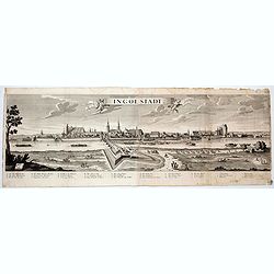
Ingolstadt.
A spectacular panoramic view of Ingolstadt in Bavaria, with legends numbered from A-P and 1-6 in German. With the title in a banderol.After a design by Friedrich Bernhard...
- $1500 / ≈ €1316
Date: Augsburg, 1729
Hamburg.
A spectacular panoramic view of Hamburg, with legends numbered 1-19 and A-Z in German. With the title in a banderol.After a design by Friedrich Bernhard Werner (1690-1776...
- $2000 / ≈ €1755
Date: Augsburg, 1729
Lübeck.
A spectacular panoramic view of Lübeck, with legends numbered 1-28 in German. With the title in a banderol.After a design by Friedrich Bernhard Werner (1690-1776) who wa...
- $1500 / ≈ €1316
Date: Augsburg, 1729
Praefectura Lipsiencis. . .
Detailed map centered around Leipzig with large pictorial cartouche and smaller cartouche of explanations. Alphabetical list of place names down both sides.
- $150 / ≈ €132
Date: Augsburg, 1730
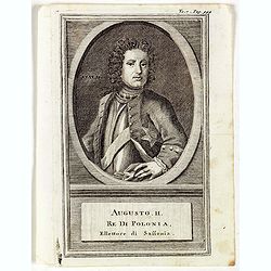
Augusti. II. Re di Polonia, Ellettore di Sassonia.
Portrait of Augustus II the Strong (12 May 1670 – 1 February 1733) of the Albertine line of the House of Wettin was Elector of Saxony (as Frederick Augustus I), Imperia...
Date: Venice, 1739
Nova Territorii Erfordien in suas praefecturas..
"Showing the area of Erfurt. In the lower part, there is a panoramic view of the town. Lower left and right splendid cartouches.The cartouches are painted in a stron...
Date: Nurenberg, 1740
Circulus Saxoniae inferioris.
Detailed map of Saxen, including Bremen, Berlin, Lübeck, etc. Johann Baptist Homann (1663-1724) was a German engraver and publisher, who established himself and his fami...
- $200 / ≈ €176
Date: Nuremberg 1740
Ducatus Magdeburgensis Et Halensis cum finitimis Delineatio geographica. . .
Very decorative map centered on Magdeburg with Elbe river. With a key to the left and right of the map.
- $75 / ≈ €66
Date: Augsburg, ca. 1740
Delineatio geographica praefecturarum Wittebergensis et Graefenhaynichen; in circulo electorali sitarum. . .
Very decorative map of Mansfeld Land, a region in the southwestern corner of the German state of Saxony-Anhalt. The region derives its name from the counts of Mansfeld, w...
- $75 / ≈ €66
Date: Augsburg, ca. 1740
Delineatio geographica praefecturarum Wittebergensis, et Graefenhaynichen. . .
Showing Amt Wittenberge with the river Elbe. Wittenberge is a town of eighteen thousand people on the middle Elbe in the district of Prignitz, Brandenburg.
- $75 / ≈ €66
Date: Augsburg, 1740
Delineatio Geographica Ditionis Martisburgensis hodie regiis et electoralibus auspiciis florentis edita. . .
Map shows the surrounding of the city of Halle. With a very large title cartouche occupying the lower left corner. Engraved by Tobias Conrad Lotter.
- $75 / ≈ €66
Date: Augsburg, 1740
Praefecturae Principatus Querfurtensis Dahmiana et Iüterboccensis cum vicinia oppidis, vicis, pagis accurate distincta. . .
Showing the region of Ämter Dahme, Jüterbog, Baruth. With in the north Potsdam and in the south Schönwalde, in the west Brück/ Zahna and in the east Buchholz/ Luckau.
- $50 / ≈ €44
Date: Augsburg, ca. 1740
Accurata recens delineata ichnographia celeberrimæ liberæ Imperii civitatis ac Sueviæ metropolis Agustæ Vindelicorum -Neu verfertigt accurater ... Haupt Stadt Augspurg.
Superb plan of the fortified town of Augsburg, brilliantly colored at the time, with title in Latin and German. The plan was designed by Johann Thomas Kraus, engraver, ar...
- $1200 / ≈ €1053
Date: Nuremberg, ca. 1740
Comitatus Stolbergici ad Hercyniam. . .
The County of Stolberg (Grafschaft Stolberg) was a county of the Holy Roman Empire located in the Harz mountain range in present-day Saxony-Anhalt, Germany. It was ruled ...
- $100 / ≈ €88
Date: Nuremberg, ca 1740
Cours du Danube, Feuille 1 contenant LA SUABE . . .
Fine map of part of the River Danube, including the southern German province of Swaben.From his rare atlas "Theatre de la Guerre en Allemagne, contenant toutes les O...
Date: Paris, 1744
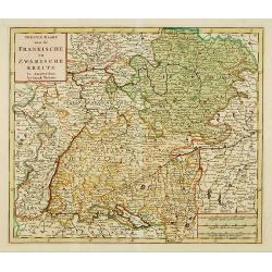
Nieuwe Kaart van de Frankische en Zwabische Kreits.
Deatailed map of the Southern part of Germany. Isaak Tirion was born in Utrecht ca. 1705. He came to Amsterdam ca. 1725. Tirion published a number of important books, m...
- $100 / ≈ €88
Date: Amsterdam, 1745

Nieuwe Kaart van de Westfaalse Kreits..
Isaac Tirion was born in Utrecht ca. 1705. He came to Amsterdam ca. 1725. Tirion published a number of important books, many of which are still in demand for their intere...
Date: Amsterdam, 1745
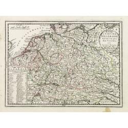
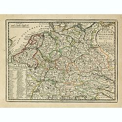
![Partie Septentrionale de la Souabe [and] Partie Meridionale de la Souabe. (2 maps)](/uploads/cache/21468-250x250.jpg)
Partie Septentrionale de la Souabe [and] Partie Meridionale de la Souabe. (2 maps)
Pair of maps forms a large, detailed view of Swabia, one of the ten circles of the Holy Roman Empire and containing some of the historically most interesting and cultural...
- $250 / ≈ €219
Date: Amsterdam c. 1745
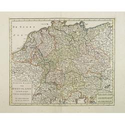
Nieuwe Kaart van Duitsland..
Detailed map of Germany, including The Netherlands, Belgium, Luxembourg, Switzerland and Austria. Isaac Tirion was born in Utrecht ca. 1705. He came to Amsterdam ca. 1725...
- $120 / ≈ €105
Date: Amsterdam, 1747
Cercle de la Basse Saxe, divisée par ses Principautés.
Small detailed map of the northern part of Germany. From Atlas Portatif Universel, by Robert de Vaugondy.Unrecorded state with erased date. Page 22 outside border top rig...
- $50 / ≈ €44
Date: Paris, later than 1749
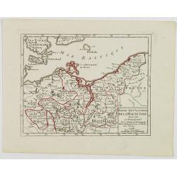
Partie Sept.le du Cercle de la Haute Saxe divisé par ses Principautés.
Small detailed map of the northeastern part of Germany, with Berlin at the bottom. Including part of Poland. From Atlas Portatif Universel, by Robert de Vaugondy.Unrecord...
- $75 / ≈ €66
Date: Paris, later than 1749
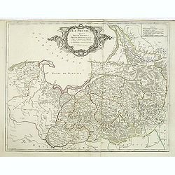
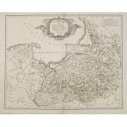
La Prusse divisée en Prusse royale, et Prusse Ducale. . .
Finely and crisply engraved map of Prussia including The Bay of Danzig. Ornamental title cartouche in the upper part of the map from his "Atlas Universel".Gille...
- $300 / ≈ €263
Date: Paris, 1750
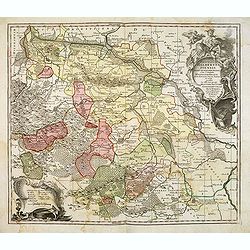
Principatus Halberstadiensis, abbat : Quedlinburgens cum Comitatu Wernigerodano, ad hodiernum verum statum ex acta prodiit ex officina geogr. . .
Detailed map showing principality Halberstadt, Abtei Quedlinburg and the county Wernigerode. Including the towns of Osterwieck, Stollberg, Aschersleben and Oschersleben.
Date: Augsburg, 1750

Dynastiae Comitat. Schoenburgici Penig, Remissa, Rochsburg, Wechselburg In Clientela Elect: Saxon Glaucha, Hartenstein, Lichtenststein, Walkenburg. . .
A very uncommon and superbly decorative map of Lower Saxony, the region southwest of Dresden. Including the towns of Rochlitz, Geringswalde, Mittweida, Frankenberg, Chemn...
Date: Augsburg, 1750
Electoratus saxonici praefecturae annaburgensis pretzschens torgaviensis schweinicensis. . .
Highly detailed map showing the regions of Annaburg, Pretzsch, Schweinitz in Sachsen-Anhalt, Torgau in Sachen and Mühlberg an der Elbe in Brandenburg. In the center of t...
Date: Augsburg, 1750
La Prusse divisée en Prusse Royale et Prusse Ducale. . .
Finely and crisply engraved map of Prussia including The Bay of Danzig. Folio map by Giles Didier Robert De Vaugondy.Ornamental title cartouche in the upper part of the m...
- $350 / ≈ €307
Date: Paris, 1751
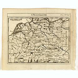
L'Allemagne.
Scarce small map of Germany, Poland and Low Countries based on cartography of Guillaume Delisle (. Published in "Nouveau traité de geographie par M**** ", publ...
- $50 / ≈ €44
Date: Paris, 1752
Cercle de Franconie . . .
Finely and crisply engraved map of part of Germany. Map by Giles Didier Robert De Vaugondy with erased title cartouche. Ornamental title cartouche in the upper part of ma...
- $50 / ≈ €44
Date: Paris, 1752
L' Allemagne par Postes.
Fine map of Germany. George Louis Le Rouge was active from 1740 to 1780 as a publisher and was appointed engineer for the King of France. From his "Atlas Nouveau Por...
- $60 / ≈ €53
Date: Paris 1756
Le Marquisat et Electorat de Branderbourg.
Fine map of Brandenburg, with decorative title cartouche. George Louis Le Rouge was active from 1740- till 1780 as a publisher, and was appointed engineer for the King of...
- $30 / ≈ €26
Date: Paris 1756
Cercle de Basse Saxe.
Fine map of Lower Saxony, with decorative title cartouche. With manuscript notes in left and right margins giving some historical information about the region. George Lou...
- $50 / ≈ €44
Date: Paris, 1756
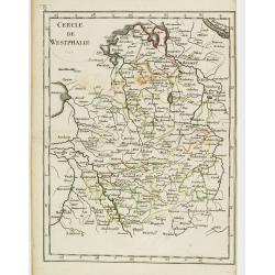
Cercle de Westphalie.
Fine map of North Rhine-Westphalia. George Louis Le Rouge was active from 1740 till 1780 as a publisher, and was appointed engineer for the King of France. From his Atlas...
- $30 / ≈ €26
Date: Paris 1756
Germania Antiqua. . .
A fine map of ancient Germany, Poland and the Netherlands from his "Atlas Universel".Gilles Robert de Vaugondy (1688–1766), also known as Le Sieur or Monsieur...
Date: Paris, 1756
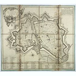
Plan de Hanover.
Town-plan of Hanover, with the new town of St Aegidien built in 1747. Decorated with a title cartouche and accompanied by a numbered key (1-79) of the main streets and bu...
- $200 / ≈ €176
Date: Paris, 1757
Neue Karte des Kuhrfürstenthums Sachsen. . .
Scarce road map, first published by Peter Schenk II (1698-1775) in his "Neuen Sächsischen Atlas". It is based on a map already created and 1732 and improved in...
- $750 / ≈ €658
Date: Amsterdam, 1758
Der Zeug=Platz gegen S.Morizen Plaz zu Augspurg.
A well-known publisher of optical prints, established in Augsburg.In the eighteenth and nineteenth centuries there were many popular speciality establishments in Paris, A...
- $200 / ≈ €176
Date: Augsburg, 1760
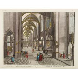
13e. Vüe d'Optique Representant L'Interieur de la Cathedralle de Dorth.
Optical view representing the interior of a Cathedral in Dörth, near Wiesbaden. Published by Daumont, a well-known publisher of optical prints, established in Paris.In t...
- $200 / ≈ €176
Date: Paris, 1760
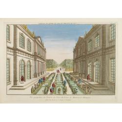
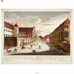
Vue perspective de l'Entrée du Parc du Prince de Manheim en Allemagne.
Perspective view of the Royal Park in Manheim by Basset, a well-known publisher of optical prints, established in rue St.Jacques in Paris. With brief key list.In the eigh...
- $200 / ≈ €176
Date: Paris, 1760
Vue perspective de la Ville et Forteresse Electorale de Koningstein, et de la Montagne de Lilienstein avec ses environs du côté du Couchant, dépendant des Etats de Saxe, appartenant à Sa Majesté le Roy de Pologne.
1760 BASSET - Perspective view of Königstein fortress, situated near Dresden in Saxony
Date: Paris, 1760

Vüe de Morestburg en Saxe, l'une des Maisons de Chasse du Roy de Pologne. (Castle Moritzburg)
So-called optical print illustrating a perspective view of the Castle Moritzburg, a Baroque Germanic castle in the small town of Moritzburg in the German state of Saxony....
- $250 / ≈ €219
Date: Paris, 1760

A view of BILNITZ in Saxony one of the palaces of the King of Poland. / Vüe de Bilnitz, en Saxe, un des Palais du Roi de Pologne.
So-called optical print illustrating a perspective view of Pillnitz Castle, a restored Baroque castle at the eastern end of the city of Dresden. The castle was once the s...
- $300 / ≈ €263
Date: Paris, 1760
Vue de la Fontaine des Eaux chaudes et de la place d'Aix la Chapelle.
So-called optical print illustrating a perspective view of Aachen, in Nordrhein Westphalia, and namely the Elisa Fountain which contains two fountains with thermal water....
- $250 / ≈ €219
Date: Paris, 1760
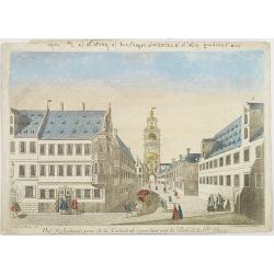
Vue d'Ausbourg prise de la Cathedrale regardant vers la Porte de la Sainte Vierge.
Charming view of the Cathedral (Dom St. Maria) in Augsburg. In top of the print the title, in mirror image, in manuscript. Published by André Basset, the younger engrave...
- $100 / ≈ €88
Date: Paris, ca 1760
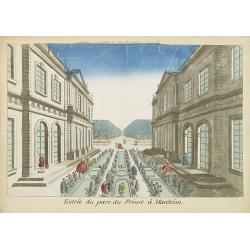
Entree du parc du Prince à Manheim.
Perspective view of the Royal Park in Manheim by Basset, a well-known publisher of optical prints, established in rue St.Jacques in Paris. With a brief key list.In the ei...
- $75 / ≈ €66
Date: Paris, 1760
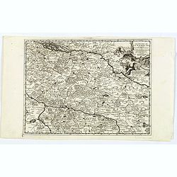
![Partie septentrionale du cercle de Haute Saxe [...] Brandebourg.](/uploads/cache/33211-250x250.jpg)
Partie septentrionale du cercle de Haute Saxe [...] Brandebourg.
Finely and crisply engraved map of north eastern part of Germany, including part of Poland. With inset map of Brandenburg. Map by Giles Didier Robert De Vaugondy with era...
Date: Paris, c. 1760
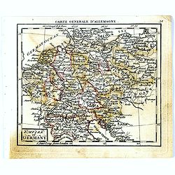
Empire of Germany.
Uncommon miniature map of Germany, Poland, the Low Countries and Eastern Europe, engraved by Thomas Kitching for "A New General and Universal Atlas Containing Forty ...
- $40 / ≈ €35
Date: London, 1761-1763
