Browse Listings in Europe > France > France Provinces
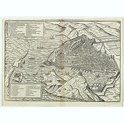
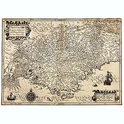
Le vray portraict de la Ville de Marseille.
Fine wood cut bird's-eye view of Marseille. Decorated with several ship in the harbour and on the sea. To the left two keys describing the main buildings and places. Publ...
Date: Paris, 1575
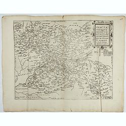
Exacta novaqve descriptio dvcatvs Andegravensis qvem vvlgari nomine Le Duche d'Aniou Indigitant.
Centered on the town of Angiers. From the first edition of De Jode's Speculum Orbis Terrarum, the second general atlas of the world, after Ortelius. Engraved by Ioannes V...
- $750 / ≈ €646
Date: Antwerp, 1578
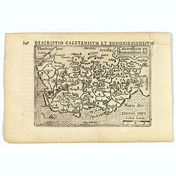
1) Caletensivm et Bononiensivm..2) Veromandvorvm eorvmque..
Prepared by Jean Surhon, cartographer, goldsmith and engraver. From 'Theatrum Orbis Terrarum [Atlas of the Whole World]': published in Antwerp.
- $200 / ≈ €172
Date: Antwerp, 1580

Beschrijvinge vande de zee Cuften va Vlanderen en Picardien. . .
A detailed description of the coast of Picardie and Normandy decorated by a large colored baroque title cartouche, and the coat of arms of Flanders with a colorful scale ...
- $1750 / ≈ €1507
Date: Amsterdam, 1585
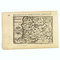
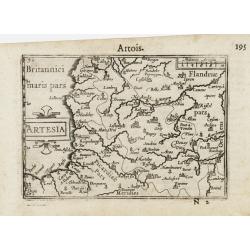
ARTESIA Comit.
Mercator's early map of the northern French region of Artois. Divisions in outline colors, strap-work title cartouche and mileage scale in the upper right, and lower left...
Date: Duisbourg, 1585

Beschrijvinge vande de zee Cuften va Vlanderen en Picardien. . .
DUTCH TEXT EDITION. A detailed chart of the coast of Flanders and Normandy decorated by a large colorful baroque title cartouche, and the coat of arms of Flanders with a ...
Date: Leiden, Plantijn, 1585
Picardiae Belgicae regionis descriptio
From Theatrum Orbis Terrarum [Atlas of the Whole World]. Prepared by Jean Surhon.Dare to go in Black. All early maps were printed in black and white, and many were kept t...
Date: Antwerp, 1590
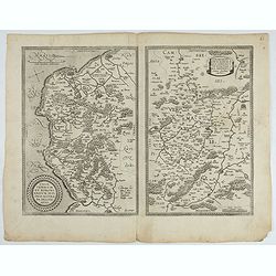
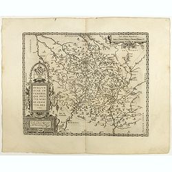
Bitvrigvm, provinciae que Berry.
A rare and beautifully engraved map from the second edition of De Jode's atlas "Speculum Orbis Terrarum". Includes the Loire Valley, centered on Bourges and Vie...
Date: Antwerp, 1593
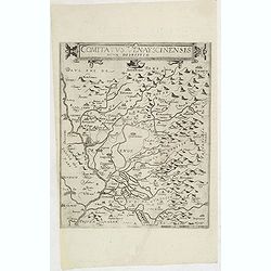
Comitatus Venayscinensis Nova Discriptio.
Rare map depicting part of Provence with Avignon, Cavaillon, Orange, Carpentras, etc.Gerard De Jode was the great rival of Ortelius, both made a living out of selling map...
- $325 / ≈ €280
Date: Antwerp, 1593
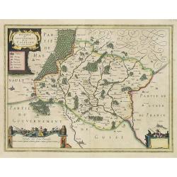
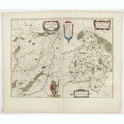
![Blaisois Blesiensis Territorii. . . [together with] - Lemovicum totius et confinium provinciarum. . .](/uploads/cache/28865-250x250.jpg)
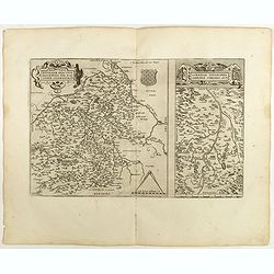
Blaisois Blesiensis Territorii. . . [together with] - Lemovicum totius et confinium provinciarum. . .
The map on the left is centered on the Loire with the town of Blois. The right hand map is centered on Limoges.
- $150 / ≈ €129
Date: Antwerp, c. 1595

Regionis Biturigum... Per Ioannem Calamaeum. / Limaniae Topographia Gabriele Symeoneo Auct.
Two maps on one sheet. Biturigum. The Loire river is at the right in central France. Neuers (Nevers) is at the middle of the right margin. Bourges is near the center, an...
- $125 / ≈ €108
Date: Antwerp, ca. 1598
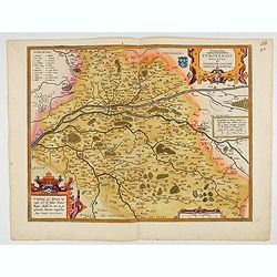
Touraine. Turonensis Ducatus.
Map of Touraine Duché in very fine original colours.
Date: Antwerp, 1598
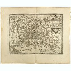
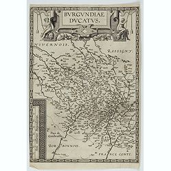
Burgundiae inferioris quae Ducatus Nomine Censetur, Des.
Map centered on the province of Burgundy, from 'Theatrum Orbis Terrarum'.Dare to go in Black. All early maps were printed in black and white; many were kept that way for ...
- $100 / ≈ €86
Date: Antwerp, 1598

Artois. Atrebatum Regionis Vera Descripto.
Prepared by Jacob Surhon, who made a manuscript map of Artois for which he received 36 Livres from Charles V in 1554. For security reasons, the map was not published. Onl...
Date: Antwerp, 1598
Regionis Biturigum... Per Ioannem Calamaeum. / Limaniae Topographia Gabriele Symeoneo Auct.
Two maps on one sheet. Biturigum. The Loire river is on the right in central France. Neuers (Nevers) is at the middle of the right margin. Bourges is near the center, and...
Date: Antwerp, 1598
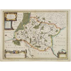
![Blaisois Blesiensis Territorii. . . [together with] - Lemovicum totius et confinium provinciarum. . .](/uploads/cache/40963-250x250.jpg)
Blaisois Blesiensis Territorii. . . [together with] - Lemovicum totius et confinium provinciarum. . .
The map on the left is centered on the Loire with the town of Blois. The right-hand map is centered on Limoges. Dare to go in Black. All early maps were printed in bla...
Date: Antwerp, 1598
Anjou. Andegavensium Ditionis Vera et Integra Descriptio. Licimo Guijeto Andegavense auctore.
Beautiful map of the Anjou region of western France along the Loire River. Include the city of Angers in the center. Accompanying French text on verso. Dare to go in B...
Date: Antwerp, 1598
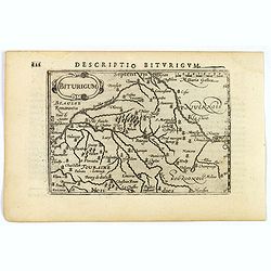
Descriptio Biturigum.
A charming small map of central France. Showing the areas around the rivers Loire, Auron, Allier and Yevre. Nevers and Bourges depicted. From the Bertius atlas Tabularum ...
- $100 / ≈ €86
Date: Amsterdam, 1606
Caletensium et Bononiesium def.
An decorative miniature map of the N.W. France, including Calais and Boulogne. A map full of detail and attractive embelishments. North is orientated to the left. From th...
- $100 / ≈ €86
Date: Amsterdam, 1606
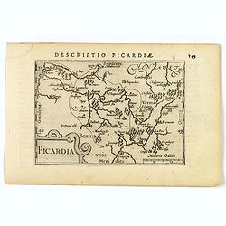
Picardia.
A decorative miniature map of Picardy, a historical northern French region. A map that appears to be sparsely populated is still full of detail with great attention to de...
Date: Amsterdam, 1606
Artesia.
A decorative miniature map of Artois, a historical northern French province that borders Belgium. A map full of detail and is expertly engraved. With the cities of Boulo...
Date: Amsterdam, 1606
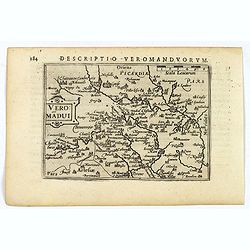
Descriptio Veromanduorum.
A decorative miniature map of Aisne (Vermandois), a French department in the Hauts-de-France region of northern France. It is named after the river Aisne. The map is cent...
Date: Amsterdam, 1606
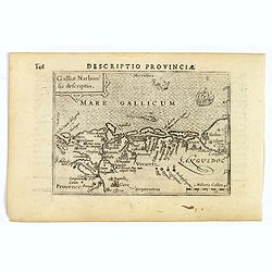
Descriptio Provinciae.
A decorative miniature map of Provence - a geographical region and historical province of south-eastern France, which extends from the left bank of the lower Rhône River...
Date: Amsterdam, 1606
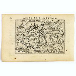
Savoie.
A decorative miniature map of Savoy - a cultural region in Central Europe that comprises roughly the territory of the Western Alps between Lake Geneva in the north and Da...
Date: Amsterdam, 1606
![Venuxinus Comitatus. [Vaucluse]](/uploads/cache/43427-250x250.jpg)
Venuxinus Comitatus. [Vaucluse]
A pleasant miniature map of the Vaucluse region of S.E. France, as published by Petrus Bertius in Amsterdam at the beginning of the seventeenth century. Many mountains as...
Date: Amsterdam, 1606
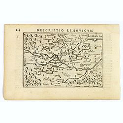
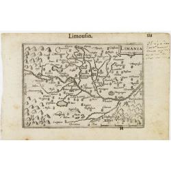
Limania.
A pleasant miniature map of the Limousin region of central France, the area surrounding Clermont Ferrand. Good map detail. From the Bertius atlas Tabularum geographicarum...
Date: Amsterdam, 1606
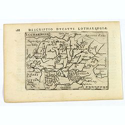
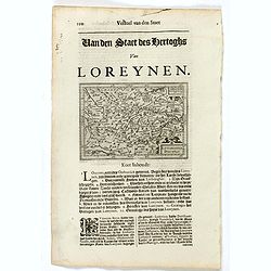
Lotharingia.
Lothringaria (Lorraine) is a historical province of N.E. France, it features the cities of Sarrebourg, Metz, Toul and Nancy. With excellent physical and topographical det...
- $100 / ≈ €86
Date: Amsterdam, 1606
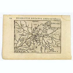
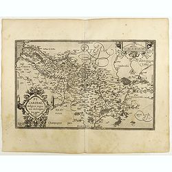
Aniou.
Anjou is a historical province of France, straddling the lower Loire River. Its capital was Angers. It bordered Brittany to the west, Maine to the north, Touraine to the ...
Date: Amsterdam, 1606
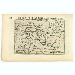
Descriptio Leodiensis Dioecesis.
A decorative map of the ancient Diocese of liege in Belgium, highlighting cities such as Huy, Liege, Tongeren (old capital), Namur and Maastricht. North is orientated to ...
- $100 / ≈ €86
Date: Amsterdam, 1606
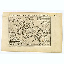
Descriptio Burgundiae Ducatus.
A decorative small map of region around Dijon, Chalons and Dole in Burgundy. Shows many rivers including the Seine, Saone and Brune. It features a nice strap-work title, ...
Date: Amsterdam, 1606
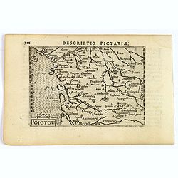
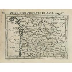
Descriptio Pictaviae.
A charming small map of Poitou in west central France. Showing Cognac, Limoges, Perigord, Poitiers and Angouleme. From the Bertius atlas Tabularum geographicarum contract...
Date: Amsterdam, 1606
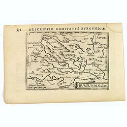
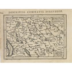
Descriptio Comitatus Burgundiae.
A decorative small map of region around Dijon, Halons and Dole in Burgundy. Features a nice strap-work title, shows rivers and settlements. From the Bertius atlas Tabular...
Date: Amsterdam, 1606
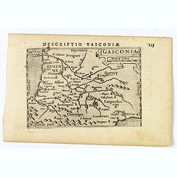
Gasconia.
A lovely miniature map of Gascony, in the S.W. region of France, published by Petrus Bertius, in Amsterdam at the beginning of the seventeenth century. There is a small s...
Date: Amsterdam, 1606
Totius Lemovici et . . .
Map of part of France, centered on Limoge, including a plan of Limoge. Prepared by Jean du Fayen (1530-1612), French physician and geographer, who prepared the first know...
Date: Amsterdam, 1608

Biturigum.
A miniature map of the Berry. Fine cartouche in the upper left corner.First published in 1598 in his Caert-Thresoor, the plates were executed by the most famous engravers...
Date: Amsterdam/Frankfurt 1609
Limania / Limousin.
A miniature map of the Limousin. Fine cartouche in the upper right corner.First published in 1598 in his Caert-Thresoor, the plates were executed by the most famous engra...
Date: Amsterdam / Frankfurt, 1609
Artesia / Artois.
A miniature map including northern part of France. Title cartouche on the left side.First published in 1598 in his Caert-Thresoor, the plates were executed by the most fa...
Date: Amsterdam/Frankfurt 1609
Burgundiae Ducatus.
Map of Burgundy region without text on the verso. Second state with the date 1597 removed from the title cartouche. This is the rarest Burgundy map of the four that Ortel...
- $500 / ≈ €431
Date: Antwerp, after 1612
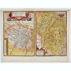
Burgundiae Ducatus. Burgundiae Comitatus.
Separately issued map of Burgundy area. Two maps of Burgundy region on a plate. Separately published map, without text on the verso. Second state with the date 1597 remov...
Date: Antwerp, after 1612
Artois. Atrebatum Regionis Vera Descripto.
Prepared by Jacob Surhon who made a manuscript map of Artois for which he received 36 Livres from Charles V in 1554. For security reasons the map was not published. Only ...
- $500 / ≈ €431
Date: Antwerp, after 1612
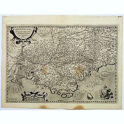
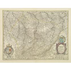
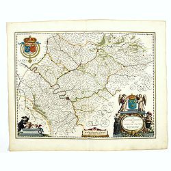
Provinciae, Regionis Galliae, vera exactissimaq. descriptio. Provence Petro Ioanne Bomparioo auctore.
A finely engraved map of the Province prepared by Pierre-Jean de Bompar who published a single sheet map of the Province in 1591. Title cartouche in the upper left-hand c...
- $500 / ≈ €431
Date: Amsterdam, 1613
Burgundia Comitatus
Text in Latin on verso.
- $80 / ≈ €69
Date: Amsterdam, 1616-1618
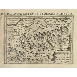
Benearnia et Bigornia.
Text in Latin on verso.
Date: Amsterdam, 1616-1618
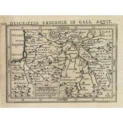
Guascogne.
Text in Latin on verso.
Date: Amsterdam, 1616-1618
Poictou.
Text in Latin on verso.
Date: Amsterdam, 1616-1618
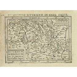
Biturigum borbonium et Turena in Gallia Aqui.
Text in Latin on verso.
- $80 / ≈ €69
Date: Amsterdam, 1616-1618
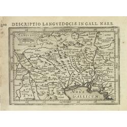
Languedoc.
Text in Latin on verso.
- $100 / ≈ €86
Date: Amsterdam, 1616-1618
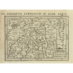
Lemovicum.
Text in Latin on verso.
- $80 / ≈ €69
Date: Amsterdam, 1616-1618
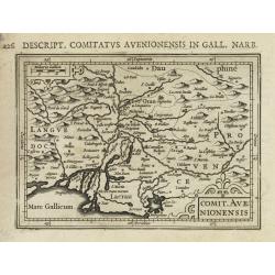
Comit. Avenionensis.
Text in Latin on verso.
- $100 / ≈ €86
Date: Amsterdam, 1616-1618
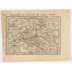
Belsia.
Text in Latin on verso.
- $80 / ≈ €69
Date: Amsterdam, 1616-1618
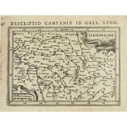
Champaigne.
Text in Latin on verso.
Date: Amsterdam, 1616-1618
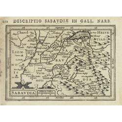
Sabaudia.
Text in Latin on verso.
- $100 / ≈ €86
Date: Amsterdam, 1616-1618
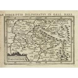
Dauphiné.
Text in Latin on verso.
- $80 / ≈ €69
Date: Amsterdam, 1616-1618
![[Lot of 17 maps] L' ISLE DE FRANCE Pariensis agri descriptio. Francois de la Hoeye fecit, Jean le Clerc excud.](/uploads/cache/19592-250x250.jpg)
[Lot of 17 maps] L' ISLE DE FRANCE Pariensis agri descriptio. Francois de la Hoeye fecit, Jean le Clerc excud.
The map of Ile de France which Jean Leclerc added in his re-issue of Maurice Bouguereau's atlas 'Theatre Francois' , as ' La Theatre geographique de France' in 1619. An u...
- $1000 / ≈ €861
Date: Paris, 1619
L'Isle de France / Parisiensis agri descrip.
Adorned with a title cartouche and a framing border. Leclerc's "Theatre geographique de France" is an extension of Bouguereau's "Theatre". A refugee w...
Date: Paris, ca. 1619
Provinciae, Regionis galliae, vera exactissimaq. Descriptio
This is a highly detailed and well engraved map of Provence in southern France. Engraved by H.Picart and published by Jean le Clerc.Jean le Clerc (1560-1621) was an engra...
- $500 / ≈ €431
Date: Paris, ca. 1620
Lotaringia Ducatus.
Small map of Lorraine, oriented with West on top and surrounded by text in Dutch. Nicolaes de Clerck (de Klerc) was active as an engraver and publisher in Delft from 1599...
- $75 / ≈ €65
Date: Amsterdam, Cloppenburch, 1621
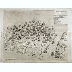
Le grand combat ov Monsieur de Montmorancy admiral de Fance . . .
Attractive view of the naval Battle of Saint-Martin de Ré, fought on 15 September 1625 between the Huguenot fleet of La Rochelle, commanded by Admiral Jean Guiton- Admir...
Date: Paris, 1625

Carte de la Coste de La Rochelle a Brouaige et de l'Isle d'Oleron Observee par le S.r de Chattillon ingenieur du Roy.
Map of the island of Oléron, with an inset in lower left corner showing the route of an English fleet to La Rochelle. At the time of mapping the area was a stronghold of...
Date: Paris, 1627
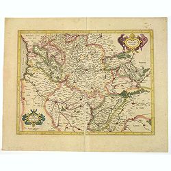
Champagne Comitatus Campania.
Map of French region of Champagne, including part of Lorraine. North to the east. The second state with the signature of J.Janssonius.
- $220 / ≈ €189
Date: Amsterdam, 1630
Description du Gouvernement de la CAPPELLE. Par P. Petit Bourbon.
Decorative map of Cappellein the region of the Nord-Pas-de-Calais in France with three decorative cartouches.The map of Cappelle is by Pierre Petit Bourbon (1598-1667), m...
- $100 / ≈ €86
Date: Amsterdam, 1631
Description du Gouvernement de la CAPPELLE. Par P. Petit Bourbon.
RARE without text on verso. Decorative map of Cappellein the region of the Nord-Pas-de-Calais in France with three decorative cartouches.The map of Cappelle is by Pierre ...
- $150 / ≈ €129
Date: Amsterdam, 1631
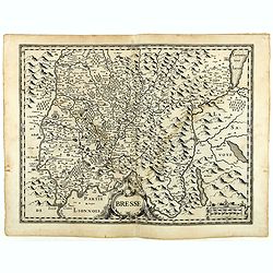
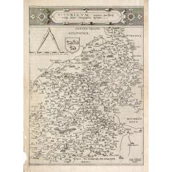
Bresse.
Early map of Eastern France with Lyon to the lower left corner and part of Switzerland. Geneva in upper right corner. Engraved by Hondius. From a French composite atlas.R...
- $150 / ≈ €129
Date: Amsterdam, 1631
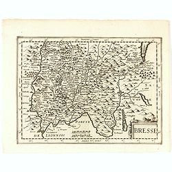
Bresse.
Early map of Eastern France and part of Switzerland. Geneva in upper right corner. With Latin text on verso. Engraved by Petrus Kaerius. Shortly after the publication of ...
- $50 / ≈ €43
Date: Amsterdam, 1632
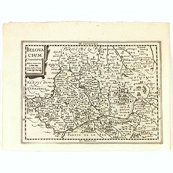
Belovacium comitatus.
Early map centered north of Paris. With Latin text on verso. Engraved by Petrus Kaerius. Shortly after the publication of big folio-atlases the need was apparently felt f...
- $75 / ≈ €65
Date: Amsterdam, 1632
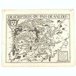
Description du pais de Valois.
Rare map published by Jean Le Clerc (1560-1621) and prepared by Damien de Templeux map of the region to the northeast of Paris, between the Oise River in the west and the...
- $300 / ≈ €258
Date: Paris, 1632

Loudunois. Laudunum / Mirebalais.
Two maps on one sheet. Centered on Loudun and Mirebeau. Showing lower left cartouche putti playing with grapes.German text on verso.
Date: Amsterdam, after 1636
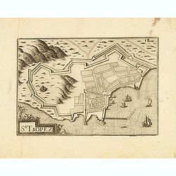
St Tropez.
Published by Nicolas Tassin in "Les Plans et Profilz de toutes principalles Villes et lieux considerable de France." The first edition of this work was publish...
- $100 / ≈ €86
Date: Paris, Sébastien Cramoisy, 1636

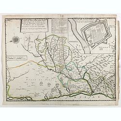
Carte du Siège Présidial Dax... Nouvellement Deseignee Par le...
Very rare map including Bayonne and Dax in the southwest of France. With inset plan of "Plan de la ville Dax.". With the address "Chez F. Dela Pointe sur l...
Date: Paris, 1638
Carte du siège présidial Dax et seneschaucee des Lannes et des sieges de Bayonne sainct sever et Tartas qui en dependent Nouvellement dessignee Par le Sr de Classun.
Very rare map including Bayonne and Dax in the south west of France. With inset plan of "Plan de la ville Dax.". Engraved by Henri le Roy. With the address &quo...
Date: Paris, 1638
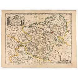
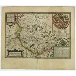
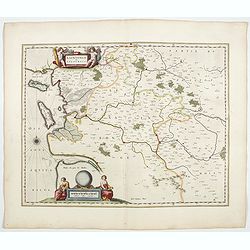
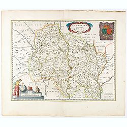
Bituricum Ducatus. Duche de Berri.
A very decorative map with beautiful cartouches of a province of France by one of the most famous map publishers. Berry is a region located in the center of France. It wa...
Date: Amsterdam, 1640
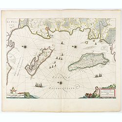
Insulae Divi Martini et Uliarus, vulgo L'Isle de Ré.. Oleron.
Map of Ré and Oléron islands. Depicting the west coast of France, showing La Rochelle. Several vessels and sailing ships dot the Atlantic ocean.Three windroses indicate...
- $950 / ≈ €818
Date: Amsterdam, 1644
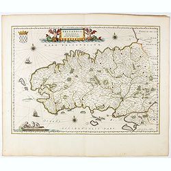
Britannia Ducatus. Duché de Bretaigne.
Map of Bretagne in France. From early on Willem Jansz. Blaeu aimed of publishing an atlas to compete with the Hondius-Jansson Atlas. By 1630, he had published at least 1...
- $650 / ≈ €560
Date: Amsterdam, 1644
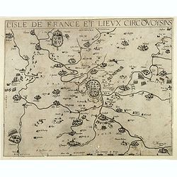
Le Gouvernement de l'Isle de France.
A very detailed map of Ile de France centered on Paris. Showing Beauvais, Compiègne, Noyon, Laon, Soisson, Vernon, Mante, Pontoise, Meaux, etc.Adorned with the royal arm...
- $300 / ≈ €258
Date: Amsterdam, 1644
Veromanduorum.. Vermandois / Gouvernement de la Capelle.
A very decorative map with beautiful cartouches of a province of France by one of the most famous map publishers. Signed by Guilielmus Blaeu.From early on Willem Jansz. B...
- $220 / ≈ €189
Date: Amsterdam, 1644
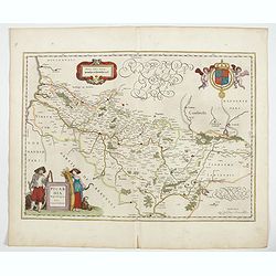
Picardia Regio Belgica.
Map of the northern region of Picardy. The region is well known due to the 4 major battles fought between France, Britain and Germany between 1915-18 during World War I. ...
- $400 / ≈ €344
Date: Amsterdam, 1644
Xaintonge et Angoumois.
This map features a portion of western coastal France, north of Bordeaux with Ile de Ré and Ile Oléron. Two large cartouches show cherubs with grapes and wheat, and tw...
- $450 / ≈ €388
Date: Amsterdam, 1644
Belsia vulgo La Beausse.
In the left-hand lower part of the image a beautiful contemporary cartouche with goddess Ceres [agricultural] holding a reaping-hook in her right hand and receiving with ...
- $200 / ≈ €172
Date: Amsterdam , 1644
Les Souverainetez de Sedan et de Raucourt.. Doncheri.
A very decorative map with beautiful large cartouches of a province of France by one of the most famous map publishers. From early on Willem Jansz. Blaeu aimed of publis...
- $175 / ≈ €151
Date: Amsterdam, 1644
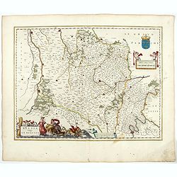
Cadurcium Vernaculé Querci.
Detailed map of a province of France by one of the most famous map publisher. Centered on Cahors.In the lower-left corner, a colored scale cartouche surmounted by a monke...
Date: Amsterdam, 1644
