Browse Listings in Europe > France > France Provinces
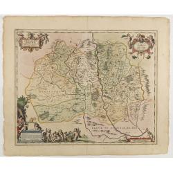
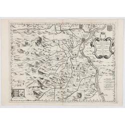
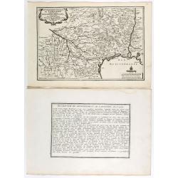
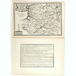
Les Souverainetez de Sedan et de Raucourt.. Doncheri.
A very decorative map with beautiful large cartouches of a province of France by one of the most famous map publishers. From early on Willem Jansz. Blaeu aimed of publis...
- $175 / ≈ €151
Date: Amsterdam, 1644
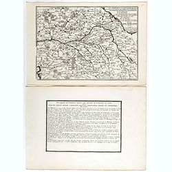
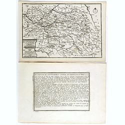
Belsia vulgo La Beausse.
In the left-hand lower part of the image a beautiful contemporary cartouche with goddess Ceres [agricultural] holding a reaping-hook in her right hand and receiving with ...
- $200 / ≈ €172
Date: Amsterdam , 1644
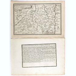
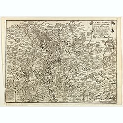
![Perchensis Comitatus [together with] Comitatus Blesensis.](/uploads/cache/44784-250x250.jpg)
Perchensis Comitatus [together with] Comitatus Blesensis.
Two maps on one sheet, each with its own decorative title cartouche. These maps detail the region of the Loire River. Perchensis includes the cities of Mortagne, Nogent-l...
Date: Amsterdam , ca 1645

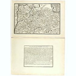
Le Duché d'Aiguillon Tracé Par le Sr. Du Vall.
Home of the "Cahors” This AOC is the most famous of the sub-regions and home to the popular variety Malbec. These inky wines have been adored for centuries, especi...
Date: Amsterdam, 1650
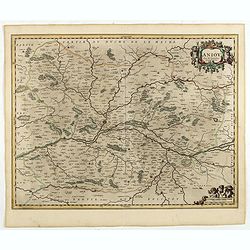
Aniou. . .
Decorative map centered on the Loire valley. Fine title cartouche in upper right corner.
Date: Amsterdam, 1650
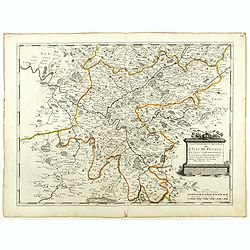
Gouvernement General de l'Ile de France. . .
Fine map of Isle de France, centered on ParisThis edition carries the date 1651. Engraved by Jean Sommer.Nicolas Sanson was to bring about the rise of French cartography,...
- $200 / ≈ €172
Date: Paris, 1651
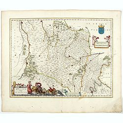
L'evesché d'Aire. . .
In center Adour (river), Aire-sur-l'Adour, with Aire and Dax in lower right corner. Janssonius does give credit to Pierre du Val. In lower left corner putti with grapes.D...
- $300 / ≈ €258
Date: Amsterdam, 1656
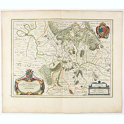
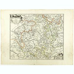
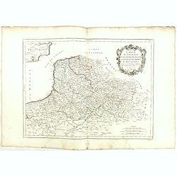
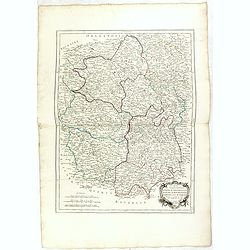
Dicecese de Rheims, et le païs de Rethel. . .
Centered on Rheims. A very decorative map with beautiful cartouches of a province of France by one of the most famous map publishers.
- $300 / ≈ €258
Date: Amsterdam, 1658
Dioecesis Sarlatensis, Vernacule.. Sarlat.
Detailed map of the region south of the Dordogne River, depicting Bergerac, Saint Cyprien, Montignac, Sarlat, Villefranche, etc.Embellished with an impressive title carto...
- $200 / ≈ €172
Date: Amsterdam, 1658
Flandria Gallica Continens Castellanias Insulense . . .
No text on verso. Map of northern part of France, centered on Lille and part of Belgium.
Date: Amsterdam, c. 1660
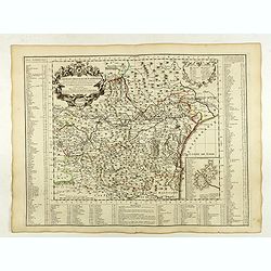
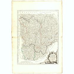
Champaigne et Brie etc.
A good engraved map of Champagne-Ardenne area, embellished with decorative title cartouche and scale cartouche with putti and surveying instruments. Paris, Metz, Reims, a...
- $150 / ≈ €129
Date: Paris, ca. 1660
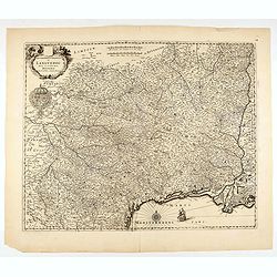
Gouvernement General de Languedoc. Divise en ses Vint Deux Diocesez.
A lovely late seventeenth century map of the central south French region of Languedoc, part of which borders the Mediterranean Sea by Dutch publisher and cartographer, Fr...
- $250 / ≈ €215
Date: Amsterdam, ca 1680

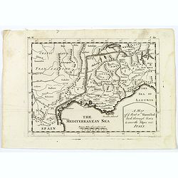
The Sea Coast of France from Ushent to Olone.
Chart showing the Brittany coast from Ushent to Ollone, with Belle-Ile. In insets : Rade de Brest and Mouth of the Loire between St. Nazaire and Nantes.Originally engrave...
Date: London, ca. 1680

The Sea Coasts of France from Olone to Cape Machicaca in Biscay . . .
Detailed chart of Biscay Bay, showing the Coast of Brittany. The chart is oriented with north-east at the top and includes two large insets of the Loire River with Nantes...
Date: London, ca. 1680
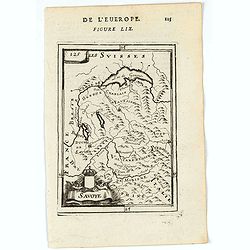
Savoye.
A charming map of Savoy. Title in a curtain draped at top. French text on verso.From the original 1683 text edition of "Description d'Univers. . ." by Allain Ma...
Date: Paris, 1683
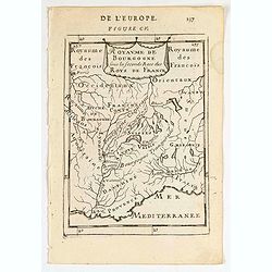
Royaume des… Royaume de Bourgogne sous la race des rois Bourguigons.
Map of Bourgogne region.Title in curtain draped at topFrom the original 1683 text edition of "Description d'Univers. . ." by Allain Manesson Mallet (1630-1706),...
Date: Paris, 1683
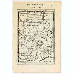
Royaume de Bourgogne sous la seconde race des roys de France.
Map of Bourgogne region.Title in a curtain draped at topFrom the original 1683 text edition of "Description d'Univers. . ." by Allain Manesson Mallet (1630-1706...
Date: Paris, 1683

Citta, porto, e rada di Brest, e . . . Nella Bretagna . . .
A beautiful and rare map of Bretagne. In top right an inset with the town of Brest.The remarkable Vincenzo Coronelli (1650-1718), encyclopaedist, geographer, inventor and...
Date: Venice, 1690

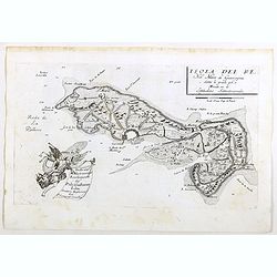
Isola d'Oleron, nella piaggie occidentali della Francia.
A beautiful and rare map showing île d'Oleron.The remarkable Vincenzo Coronelli (1650-1718), encyclopaedist, geographer, inventor and Doctor of Theology, was citizen of ...
Date: Venice, 1690
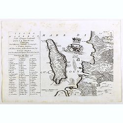
Isola del Re Nel Mare di Guascogna . . .
A beautiful map showing Ile de Ré in Bretagne, located in the Bay of Biscay off the coast of France, from Vincenzo Coronelli's Corso Geografico Universale.Italian text o...
Date: Venice, 1690
Isola d'Oleron, nella piaggie occidentali della Francia.
A beautiful and rare map showing île d'Oleron.The remarkable Vincenzo Coronelli (1650-1718), encyclopaedist, geographer, inventor and Doctor of Theology, was citizen of ...
Date: Venice, 1690
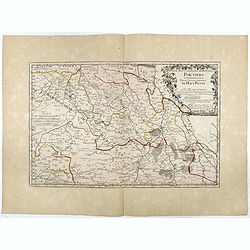
Partie Septentrionale de l'Evesché de Poictiers. Partie Septentrionale du Haut Poitou.
Rare map engraved by R. Michault and published "a Paris chez Greg. Mariette sur le quay de l'Horloge au dessus de la cour de Lamoignon". Dedicated to the Bishop...
Date: Paris, 1690
Contado DE Venassino, E prencipato d'Oranges . . .
A most attractive and decorative map centered on Avignon and Orange, by Vincenzo Coronelli. An elaborate title cartouche garlanded with intertwined flowers and dedicated ...
- $400 / ≈ €344
Date: Venise 1690

Gouvernement general de Champagne. . .
Fine map of Champagne with a decorative title and scale cartouche.Alexis-Hubert Jaillot (1632-1712), was a French cartographer. He joined the Sanson heirs and redrew Nico...
Date: Amsterdam, 1692
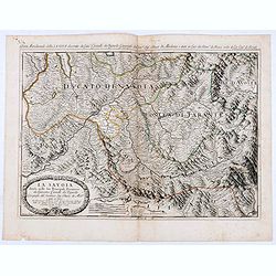
La Savoia divisa nelle sue Principali Provincie da Giacomo Cantelli da Vignola . . .
Late 17th century maps of the Savoy region, based on the reports of Giacomo Cantelli da Vignola and published in Roma in Giacomo de Rossi's world atlas Mercurio Geografic...
- $250 / ≈ €215
Date: Rome, 1692

Le comte d'Artois dresse sur les memoires les plus nouveaux. . .
Map showing the north of France, showing St Omer, and Arras, etc. The map notes Nicolas Sanson as the mapmaker and claims that the map was published by Alexis-Hubert Jail...
Date: Amsterdam, 1693
Disegno Idrografico del Canale Reale . . .
A decorative Coronelli map showing the Canal du Midi. It shows the extent of the canal from the Mediterranean sea at Narbonne to Toulouse. Featuring a pair of large coats...
- $300 / ≈ €258
Date: Venice, 1695-1697
Carte du Diocese de Narbonne.
Topographically detailed map of the Narbonne diocese in southwestern France. Includes major roads and is supplemented with an extensive index. Inset map plan of the forti...
Date: Paris, 1704

Carte particuliere d'une grande partie des estats situez sur le haut rhein et sur les rivieres qui si déchargent comme sont L'Alsace, la Souabe et la Lorraine,&c. . .
Detailed map of Alsace, Lorraine and Souabe, centered on the River Rhine.
Date: Paris, 1705
Gouvernement general de Languedoc . . .
Map of the Languedoc region, from Nicolas de Fer's "L'Atlas curieux ou le Monde réprésente dans des cartes. "The "Atlas Curieux" is a geographic enc...
Date: Paris, 1705
Les Provinces, ou Gouvernement de Poictou, d'Anjou, du Maine, De Touraine . . .
Map centered on Loire region, with Blois, Saumur, Sancerre and Orleans, from Nicolas de Fer's "L'Atlas curieux ou le Monde réprésente dans des cartes. "The &q...
Date: Paris, 1705
Gouvernement general du Lionnois, generalitez de Lion et de Riom . . .
Map of central France with Clermont-Ferrand and Lyon to the right, from Nicolas de Fer's "L'Atlas curieux ou le Monde réprésente dans des cartes. "The "A...
Date: Paris, 1705
Gouvernement de Dauphiné, Generalité de Grenoble.
Map of the Dauphiné region, from Nicolas de Fer's "L'Atlas curieux ou le Monde réprésente dans des cartes. "The "Atlas Curieux" is a geographic enc...
Date: Paris, 1705
Gouvernement general de Picardie . . .
Map of the Picardie region, from Nicolas de Fer's "L'Atlas curieux ou le Monde réprésente dans des cartes. "The "Atlas Curieux" is a geographic ency...
Date: Paris, 1705
Les Gouvernements generaux de l'Isle de France et de Champagne, ou se trouvent les generalitez de Paris et Chaalons.
Map of the Isle de France and Champagne regions, from Nicolas de Fer's "L'Atlas curieux ou le Monde réprésente dans des cartes. "The "Atlas Curieux"...
Date: Paris, 1705
Le Païs Messin, ses dependances, et Terre Adiacentes.
Map of the Messin region, from Nicolas de Fer's "L'Atlas curieux ou le Monde réprésente dans des cartes. "The "Atlas Curieux" is a geographic encycl...
Date: Paris, 1705
Carte du Diocese de Beziers . . .
Fine map of the diocese of Béziers with the address : A Paris Chez l’Auteur sur le Quai de l’Horloge a l’Aigle d’Or, avec Privil. Pr . 20 ans Mai 1708.In early 1...
Date: Paris, 1708
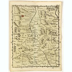
(Clermont, Brioude, Le Puy, etc.)
Rare miniature map including the towns of Clermont, Brioude, Le Puy, etc. From "Le theatre De Bellone, Contenant 48. nouvelles Cartes Geographiques, Des Païs-Bas Es...
- $60 / ≈ €52
Date: Amsterdam, 1710
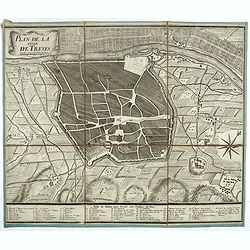
Plan de la ville de Treves.
Very rare town-plan of Trier by Didier Bugnon (1676-1736), geographer of the Duke of Lorraine. With numbered key (1-57) of the main buildings and buildings of the city. T...
Date: Paris?, 1720

Carte du Gouvernement de Provence, suivant les nouvelles observations...
Fine copper engraved and decorative map of the Provence region in the south of France. It includes the cities of Nimes, Viviers, Avignon, Aix and Nice. The pictorial cart...
Date: Amsterdam 1728
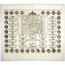
Carte Historique et Geographique pour Introduire a l' Intelligence de l'Histoire de Savoye . . .
Folio sheet with an attractive map of the border region of France, Switzerland and Italy. An inset map of the fortification of Torino and the Palace of Venerie. Cartouche...
Date: Amsterdam, 1728
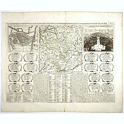
Carte Pour L'Intelligence De L'Histoire De Lorraine . . .
Map of Lorraine, surrounded by 34 portraits of the rulers of Lorraine and information concerning the present government structure of the Duchy. Surmounted by an elaborate...
Date: Amsterdam, 1728

Plan de la Ville et Port d'Antibes.
An attractive chart centered on the Mediterranean. With a scale and large compass-rose. Dated 1727, with the privilege of the King. From : Recueil des Plusieurs plans des...
Date: Marseille, 1730

Plan de la Baye de Ville Franche et de celle de St. Souspir.
An attractive chart centered on the Mediterranean. With scale and large compass-rose. Dated 1727, with the privilege of the King. From : Recueil des Plusieurs plans des p...
Date: Marseille, 1730
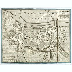
Nouveau plan de Dieppe, ville et port de mer de la Normandie.
Beautiful plan showing the fortified town of Dieppe and the suburbs of Barre and Pollet, engraved by Inselin. Beautiful example.
- $230 / ≈ €198
Date: Paris, ca. 1730
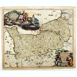
Nova et accurata Normandiae Ducatus Tabula . . .
This very rare map of Britany made by the Amsterdam publisher and Pieter Persoy (1675-1695). This among fourteen other maps are sometimes found in atlases by Frederik de ...
Date: Amsterdam, 1730
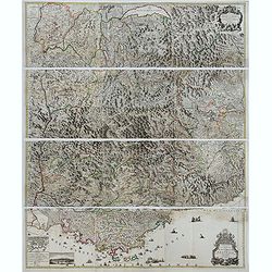
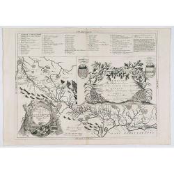
Theatre de la Guerre en Savoie et en Piémont - Le Dauphiné, La Bresse - Partie du Lionnois et de la Provence./ Theatre de la guerre en Dauphiné et en Provence…
Rare wall map of the Savoie/Piémont and Dauphiné/Provence region. Decorated with 2 title-cartouches, one at upper right part (Savoye/Piémont) and one at lower right pr...
- $3000 / ≈ €2583
Date: Amsterdam, c.1735

Picardie Meridionale Le Cambresis et leurs Environs.
Map showing the region of Picardie in Northern France. Including the towns of Abbeville, Amiens, Compiegne, Soisson, Chambray, etc.
Date: Paris, 1737
![[Lot of 5 maps of the mouth of the Gironde river] Carte des Entrees et Cours de la Gironde](/uploads/cache/86010-250x250.jpg)
[Lot of 5 maps of the mouth of the Gironde river] Carte des Entrees et Cours de la Gironde
A large sea chart of the mouth and course of the Gironde river as far inland as Bordeaux. Decorated with three cartouches.Jacques Nicolas Bellin (1702-720) was the most i...
- $350 / ≈ €301
Date: Paris, c. 1740
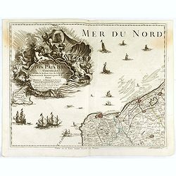
Carte des Pais Bas contenant la Flandre, le Brabant, Pais de Liege. . .
Map sheet from a multi-sheet map of the Low Countries, showing a large title cartouche and part of the Northern French coast line around Calais, Duinkerken and Furnes. Th...
- $75 / ≈ €65
Date: Paris, 1742

Plan du Golfe et des Caps de St. Tropez. par Jacques Ayrouard . . .
Large plan of the harbour St. Tropez. Decorated with a large compass rose.From the rare chart book by Jacques Ayrouard: "Recueil de plusieurs plans des ports et rade...
Date: Marseille, 1732-1746
A Map of the Rout which Hannibal took through Gaul & over the Alpes into Italy.
A map showing the (clear) route the North African, Carthaginian General Hannibal took to get from Spain to northern Italy, via France and the Alps. Ancient, Latin names a...
Date: London, 1747
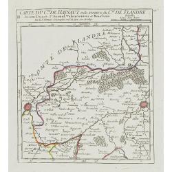
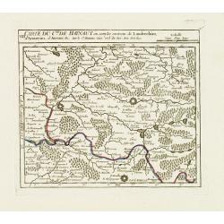
III. Carte du C.té de Haynaut et des Frontieres du C.té de Flandre..
Attractive small map encompassing part of the Nord, between Douai and Valenciennes.From Atlas Portatif Universel, by Robert de Vaugondy.Unrecorded state with erased date....
Date: Paris, after 1748
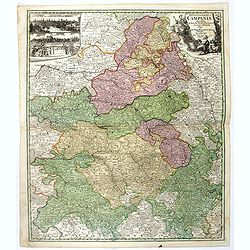
Tabula Geographica Campaniae. . .
Map of the Champagne region with Rheims, Châlons, Vitry in the center. In upper left corner two inset views with the towns of Reims et Troyes.
- $225 / ≈ €194
Date: Nuremberg, ca. 1750

Carte particuliere des costes de Poittou, Aunis et de la Rochelle.
Finely designed and rare map of Isle Ré and the French coast with La Rochelle.
- $1250 / ≈ €1076
Date: Amsterdam, c. 1750
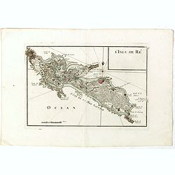
L'Isle de Ré.
Fine map of the French island called Île de Ré. George Louis Le Rouge was active from 1740- till 1780 as a publisher, and was appointed engineer for the King of Franc...
Date: Paris, 1756
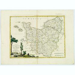
Li Governi di Normandia del Maine e Perche. . .
An attractive map that encompasses all of Normandie with the semi-autonomous English Channel Islands islands of Alderney, Jersey & Guernsey, Maine in the French provi...
Date: Venice, 1777
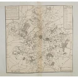
Carte particuliere semi-topographique de l'election de Paris. . .
Very decorative maps. Maps of the Parisian region. Map including Luzarches, Orgeval, Arpajon, Bussy saint georges.
- $300 / ≈ €258
Date: Paris 1779
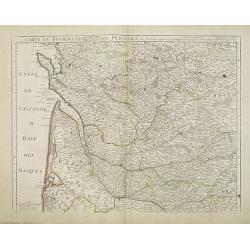
Carte du Bourdelois du Perigord et des provinces voisines..
Map covering the area from La Rochelle till the surrounding country of Bordeaux to the south and till Limoges and Cahors to the east.
- $120 / ≈ €103
Date: Paris, c. 1780
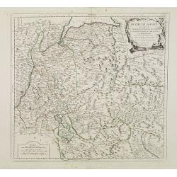
Duché de Savoye qui comprend..
Finely and crisply engraved map of Savoy. Venetian edition of de Vaugondy's map, from "Atlas Universel" printed in 1776-84.Large decorative title cartouche in t...
- $150 / ≈ €129
Date: Venice, 1776 - 1784
Gouvernements de Flandre Françoise, d'Artois, de Picardie. . .
Detailed map encompassing northwestern part of France, with the Channel and tip of southern England. With ornamental title cartouche and noteworthy topographical detail.T...
- $100 / ≈ €86
Date: Venice, 1776 - 1784
Gouvernement de l'Isle de France et de celui de l'Orléanois. . .
Detailed map encompassing present day north of France.Venetian edition of the map by Bellin, to whom Santini gives credit in the cartouche.From "Atlas Universel"...
- $100 / ≈ €86
Date: Venice, 1776 - 1784
Gouvernements de Champagne et Brie.
Detailed map encompassing Champagne and Brie.Venetian edition of the map by Bonne, to whom Santini gives credit in the cartouche.From "Atlas Universel" publishe...
- $75 / ≈ €65
Date: Venice, 1776 - 1784
Gouvernements de Lorraine et d'Alsace.
Detailed map encompassing present day the east of France.Venetian edition of the map by Bonne, to whom Santini gives credit in the cartouche.From "Atlas Universel&qu...
- $100 / ≈ €86
Date: Venice, 1776 - 1784
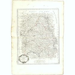
Gouvernements de Berri, du Nivernois,de la Marche, Limousin..
Detailed map encompassing Berri, Nivernois, Limousin and Auvergne.Venetian edition of the map by Bonne, to whom Santini gives credit in the cartouche.From "Atlas Uni...
- $75 / ≈ €65
Date: Venice, 1776 - 1784

Plan de St. Jean de Luz avec les différents projets d'agrandissem.t du port.
Very rare and beautiful plan of the city and bay of Saint-Jean-de-Luz, detailing the projects of expansion of the port undertaken in 1780.The plan indicates the Artha Roc...
- $2200 / ≈ €1895
Date: Paris, 1784
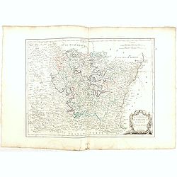
Gouvernements de Bourgogne, de Franche Comté et de Lyonnois.
Detailed map encompassing Bourgogne, Franche Comté and Lyonnois.Venetian edition of the map by Bonne, to whom Santini gives credit in the cartouche.From "Atlas Univ...
- $100 / ≈ €86
Date: Venice, 1776 - 1784
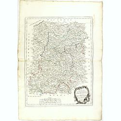
Carte de la Marche, du Bourbonnois, de Limousin, et de l'Auvergne.
Very fine map of Auvergne, Limousin, Bourbonnois and Marche regions in France. Engraved by Ballet and included in the rare atlas "Atlas Universelle" by Philippe...
- $150 / ≈ €129
Date: Paris, 1787

Il Governo di Guascogna con porzione del Governo di Guienna.
Rare regional map of France of the Périgord, Guienne, Gascogne and the Béarn published by Carli Pazzini in Siena.
Date: Siena, 1792
Les environs de Mons, Beaumont, Chimay, Valenciennes, Condé, &c.
Detailed map of Northern France, centered on Valenciennes and Mons. The map was prepared by Jean Baptiste de Bouge (1757-1833), who prepared one of the first very detaile...
- $50 / ≈ €43
Date: Bruxelles 1789 - 1793
VIII. Carte du C.té de Haynaut où sont les environs de Landrechies..
Attractive small map showing an area straddling the regions Picardy and Nord. It shows the towns of La Capelle, Landrecies and Avesnes-sur-Helpe.From Atlas Portatif Unive...
Date: Paris, 1799

Theodorus Primus Corsicae Rex.
Portrait of Everard Jabach, three-quarter length, standing by the fragment of a column, facing left, wearing a cloak and doublet with plain collar, his left arm held behi...
Date: Paris, 1652 - 1800
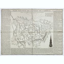
Plan nouveau de la ville de Cambrai.
Nice town-plan of Cambrai, with its fortifications and the citadel, decorated with the cathedral in lower right corner. The borders contain a historical description of th...
Date: Cambrai, 1814
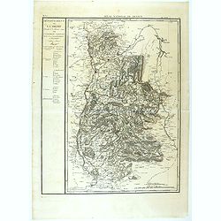
Département de la Drome decreté le 3 février 1790. . .
Map of the region of southeast France. The region of Drome is divided into four districts. On the left, the title with underneath a large explicative text with the divisi...
Date: Paris, 1790-1818
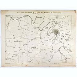
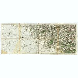
Tableau d'assemblage de la carte des environs de Versailles dite chasses impériales.
Key sheet to the rare 12 sheet map "Carte topographique des environs de Versailles dite des Chasses Impériales, levée et dressée de 1764 à 1773 par les ingénieu...
Date: Paris, ca. 1820
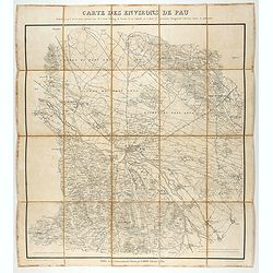
Carte des environs de Pau. . .
Folding map of Pau and its surroundings, being a reduced version of the map by Comte Dulong de Rosnay and engraved by Nicolas Delamare and published by Lafon.More about f...
- $75 / ≈ €65
Date: Pau, Lafon, 1840-1850
![Dépt. De L'Aude. N°10. [ Carcassonne ]](/uploads/cache/27089-250x250.jpg)
Dépt. De L'Aude. N°10. [ Carcassonne ]
Map of the Aude region, centered on the town of Carcassonne. Reaching to the right till the Mediterranean.Lovely map from one of the last decorative atlases of the ninete...
Date: Paris, A. Combette, 1852
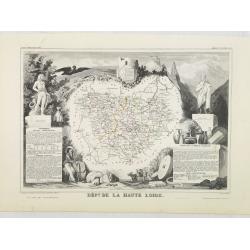
Dépt. De La Haute Loire. N°42.
Map of the Upper Loire region in France.Lovely map from one of the last decorative atlases of the nineteenth century.The rather simple map is framed by medallion portrait...
- $50 / ≈ €43
Date: Paris, A. Combette, 1852
![Dépt. du Morbihan. N°. 55. [ Morbihan, Belle-Ile ]](/uploads/cache/43041-250x250.jpg)
Dépt. du Morbihan. N°. 55. [ Morbihan, Belle-Ile ]
Map of the Morbihan region in Brittany. Including "Belle-Ile".Lovely map from one of the last decorative atlases of the nineteenth century.The rather simple map...
Date: Paris, A. Combette, 1852
Province ecclesiastiche di Parigi, Rouen, Rheims, E Cambray in Francia (Tav LIV)
This large-format Paris, Rouen, Reims and Cambray map is finely engraved and beautifully colored and was prepared by Girolamo Petri, a lawyer who served as a senior offic...
- $300 / ≈ €258
Date: Rome, 1858
