Browse Listings in Europe > France > France Provinces
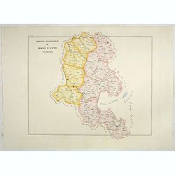
Province ecclesiastiche di Lione e Sens in Francia (Tav LV)
This large-format Lion and Sens map is finely engraved and beautifully colored and was prepared by Girolamo Petri, a lawyer who served as a senior official within the Vat...
- $300 / ≈ €258
Date: Rome, 1858
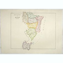
Province ecclesiastica di Besançon in Francia (Tav LVI)
This large-format Besançon map is finely engraved and beautifully colored and was prepared by Girolamo Petri, a lawyer who served as a senior official within the Vatican...
- $300 / ≈ €258
Date: Rome, 1858
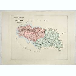
Province ecclesiastica di Tours e Rennes in Francia (Tav LVII)
This large-format Tours and Rennes map is finely engraved and beautifully colored and was prepared by Girolamo Petri, a lawyer who served as a senior official within the ...
- $300 / ≈ €258
Date: Rome, 1858
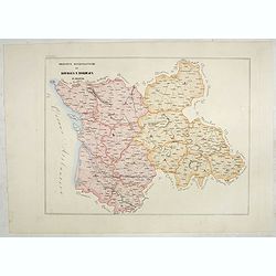
Province ecclesiastiche di Bourges e Bordeaux in Francia (Tav LVIII)
This large-format Bourges and Bordeaux map is finely engraved and beautifully colored and was prepared by Girolamo Petri, a lawyer who served as a senior official within ...
- $300 / ≈ €258
Date: Rome, 1858
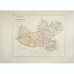
Province ecclesiastiche di Albi, Auche e Toulouse in Francia (Tav LIX)
This large-format Albi, Auch and Toulouse map is finely engraved and beautifully colored and was prepared by Girolamo Petri, a lawyer who served as a senior official with...
- $300 / ≈ €258
Date: Rome, 1858
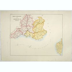
Province ecclesiastiche di Avignone ed Aix in Francia (Tav LX)
This large-format Avignon and Aix map is finely engraved and beautifully colored and was prepared by Girolamo Petri, a lawyer who served as a senior official within the V...
- $300 / ≈ €258
Date: Rome, 1858

Souvenirs des Pyrénées. Vues prises aux environs des eaux thermales de Bagnères-de-Bigorre, Bagnères-de-Luchon, Cauteretz, Saint-Sauveur, Barèges, Les-eaux-Bonnes, Les-Eaux-Chaudes & Pau.
The thermal baths Bagnères de Bigorre, Bagnères de Luchon, Cauteretz, Saint-Sauveur, Barèges, Les Eaux-Bonnes and Pau in the Pyrenees. Beautiful collection of 24 litho...
Date: Pau, A.Basset, ca. 1860
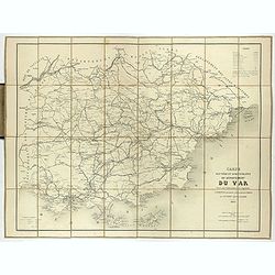
Carte routière et administrative du département du Var dressée sous l'administration et l'approbation de M. Montois, officier de la légion d'honneur, préfet , par J.B CHABET.
Folding-map of the Maritime Alps, and the Mediterranean coastline of Fréjus, Ramatuelle, St Tropez, Toulon. Engraved by Erhard, geographer and engraver (1821-1880) at th...
- $125 / ≈ €108
Date: Paris, 1865
![[Les anciennes provinces Françaises à la ville de Saint Denis].](/uploads/cache/41681-250x250.jpg)
[Les anciennes provinces Françaises à la ville de Saint Denis].
Nine small chromolithography's trade cards for Ville de Saint Denis, each with French regions and places, with description in French on each verso.Cards of the regions : ...
Date: Paris, circa 1900
![[Les anciennes provinces Françaises à la ville de Saint Denis].](/uploads/cache/41683-250x250.jpg)
[Les anciennes provinces Françaises à la ville de Saint Denis].
Nine small chromolithography trade cards for Ville de Saint-Denis, each with French regions and places, with description in French on each verso.Cards of the regions: Lor...
Date: Paris, circa 1900
![[Les anciennes provinces Françaises à la ville de Saint Denis].](/uploads/cache/41684-250x250.jpg)
[Les anciennes provinces Françaises à la ville de Saint Denis].
Nine small chromolithography's trade cards for Ville de Saint Denis, each with French regions and places, with description in French on each verso.Cards of the regions : ...
Date: Paris, circa 1900

Languedoc - Foix Roussillon.
Very decorative, informative map of Languedoc - Foix Roussillon region in south eastern France. Including the towns of Carcassonne, Montpellier, Albi, Toulouse, etc.The m...
Date: France, 1943

Guyenne - Gascogne.
Very decorative, informative map of Guyenne and Gascogne region in France. The map is filled with buildings, animals, figures and two locals. With a large compass rose in...
Date: France, 1943
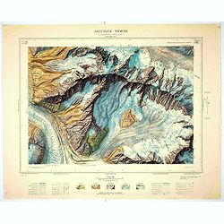
Aiguille verte - Chamonix N°6 Sud
Magnificent 1:10,000 scale color printed map of l'Aiguille verte (Chamonix N°6 Sud) based on stereotopographic ground and aerial surveys carried out in the field in 1950...
Date: Paris, 1953
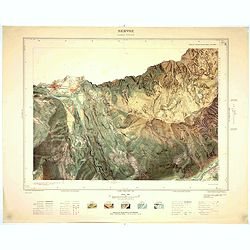
Servoz - Cluses N°8 Sud.
Magnificent 1:10,000 scale color printed map of Servoz (Cluses N°8 Sud) based on stereotopographic ground and aerial surveys carried out in the field in 1950 and render...
Date: Paris, 1953
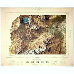
Le Buet - Chamonix N°1 Sud. / Massif des Aiguillles Rouges.
Magnificent 1:10,000 scale color printed map of Le Buet (Chamonix No. 1 South) / "Massif des Aiguilles Rouges" based on stereotopographic ground and aerial surv...
Date: Paris, 1953
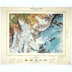
Aiguille du Midi - Mont Blanc N°1 Nord.
Magnificent 1:10,000 scale color printed map of L'Aiguille du Midi (Mont Blanc N°1 Nord) based on stereotopographic ground and aerial surveys carried out in the field in...
Date: Paris, 1953
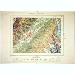
Chamonix - Mont Blanc - Chamonix N°5 Sud.
Magnificent 1:10,000 scale color printed map of Chamonix - Mont Blanc (Chamonix N°5 Sud) based on stereotopographic ground and aerial surveys carried out in the field in...
Date: Paris, 1953
