Browse Listings in Europe
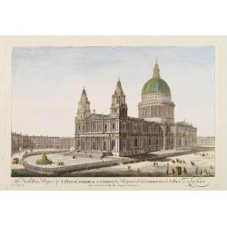
The North West Prospect of S. Pauls Cathedral in London.
Uncommon optical print illustrating a view of St. Paul's Cathedral in London.In the eighteenth and nineteenth centuries there were many popular speciality establishments ...
- $275 / ≈ €234
Date: Paris, 1760

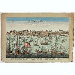
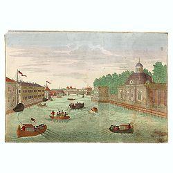
A view of Amsterdam taken from the Old Rampart.
So-called optical print of Amsterdam, published by Jean Mondhare after a print by Laurie and Wtitle. With captions in English and French above and belowIn the eighteenth ...
Date: Paris, ca. 1760
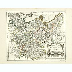
![Partie septentrionale du cercle de Haute Saxe [...] Brandebourg.](/uploads/cache/33211-250x250.jpg)
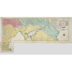
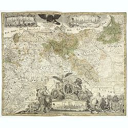
Partie septentrionale du cercle de Haute Saxe [...] Brandebourg.
Finely and crisply engraved map of north eastern part of Germany, including part of Poland. With inset map of Brandenburg. Map by Giles Didier Robert De Vaugondy with era...
Date: Paris, c. 1760
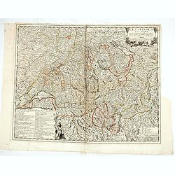
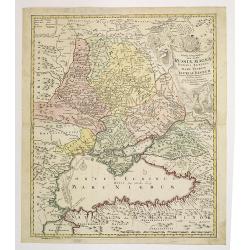
Carte géographique représentant le théâtre de la guerre entre les Russes, les Turcs et les Polonois confédérés. . .
Interesting and rare map showing the area of the Russo-Turkish Wars. To the right a large title cartouche and extensive text describing the different stages and the Wars ...
- $1500 / ≈ €1275
Date: Augsburg, 1760
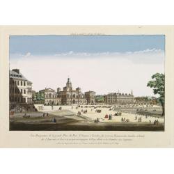
Vüe Perspective de la grande Place du Parc St. Jacques à Londres, du nouveau Batiment des Gardes a Cheval, de l'Amirauté..
So-called optical print illustrating a cortege of subjects accompanying the king to the House of Lords along the Horse guards Road in St. James's Park, in London.The Old ...
- $200 / ≈ €170
Date: Paris, 1760

Prospect des grossen Arno Platzes in Florenz.
Rare so-called optical print illustrating a Street scene in Florence with the Palazzo Vecchio (town hall) and its Duomo (cathedral) in the background. Engraved by Balth F...
- $250 / ≈ €212
Date: Augsburg, 1760
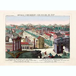
Prospect der Überbleibssel von altem Rome. - Vue du Reste des Antiquites a Rome.
A rare so-called optical print illustrates Roman Forum, ancient Rome's showpiece center, a grandiose district of marble-clad temples, proud basilicas and vibrant public s...
- $250 / ≈ €212
Date: Augsburg, 1760
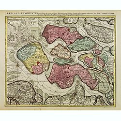
Zeelandiae Comitatus. . .
Scarce map of Zeeland, this is the state published by Tobias Conrad Lotter, previously published by Matthäus Seutter.Impressive cartouche with coat of arms of Zeeland to...
Date: Augsburg, c.1760
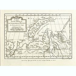
Carte des Païs habités par les Samojedes et Ostiacs, pour l'histoire générale des voyages.
Map shows Nova Zembla and the area of northern Russia that was inhabited by the Samoyeds and Ostiacs.Prepared by Jacques Nicolas Bellin after Dutch sources and included i...
- $75 / ≈ €64
Date: Paris, 1760
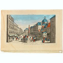
Vue et Perspective de la Trinité a Vienne.
Decorative perspective view of a square in Vienna centered on the column which represents the Trinity. Published by Jacques François Chereau [1742 -1794], who was active...
- $200 / ≈ €170
Date: Paris, 1760
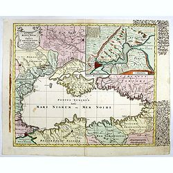
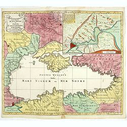
Nova Mappa Maris Nigris et Freti Constantinopolitani...
Map of the Black Sea with the Crimea and adjacent countries, inset map of the Bosporus with Constantinople at upper right.T.C. Lotter married M. Seutter's daughter in 174...
- $600 / ≈ €510
Date: Augsburg, ca. 1760
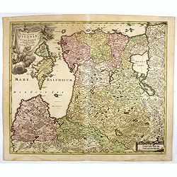
Dvcatvvm Livoniae et Cvrlandiae cum vicinis insulis nova exhibitio geographica.
A very attractive of Livonia, Estonia, Curlandia and the Baltic coast, which also includes the Gulf of Livonia or Riga.
- $500 / ≈ €425
Date: Nuremberg, 1760
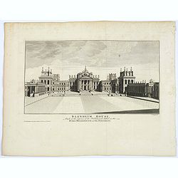
Blenheim House.
An attractive view of the front of Blenheim House (now Palace) home to the present 12th Duke and Duchess of Marlborough. The house was begun in 1705, built by Sir John Va...
- $50 / ≈ €42
Date: London, ca. 1760
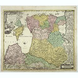
Dvcatvvm Livoniae et Cvrlandiae cum vicinis insulis nova exhibitio geographica.
A very attractive of Livonia, Estonia, Curlandia and the Baltic coast, which also includes the Gulf of Livonia or Riga.
- $450 / ≈ €382
Date: Nuremberg, 1760
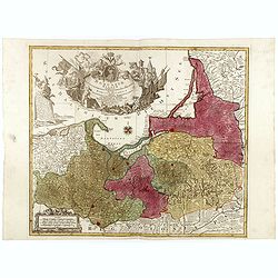
Borussiae Regnum compectens Circulos Sambiensem, Natangiensem, et Hockerlandiae Nee non Borussia Polonica, exhibens Palatinatus Culmiensem. . .
Decorative map covering northern Poland with Prussia, Pomerania, Hockerlandia, Warmiaermelandia, Natanglensis, Galindia, Nandrovia, Sclavonia, and the Baltic Sea. Include...
- $400 / ≈ €340
Date: Augsburg, ca. 1760
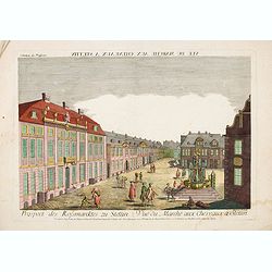
Prospect des Rossmarcktes zu Statin - Vue du Marché aux Cheveaux a Stettin.
Rare so-called optical print illustrating the Horse market of Stettin in Poland. Engraved by F. Riedel. The Academie Imperiale was a well-known publisher of optical print...
- $600 / ≈ €510
Date: Augsburg, 1760
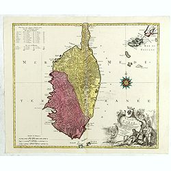
L'isle de Corse avec les différents districts, appartenante à la République de gênes . . .
Map published during the uprising of the Corsican people against the Republic of Genoa. It is decorated with a wind rose compass and a beautiful title cartouche decorated...
Date: Augsburg, 1760
Generale Carte der gesamten Koniglichen Preussischen Lander. . .
Beautiful and rare two sheet map of Prussia. The title cartouche is hold by a crowned eagle. In lower part a large baroque cartouche with allegorical figures and a portra...
- $1200 / ≈ €1020
Date: Berlin, 1760
Nova Mappa Maris Nigri et Freti Constantino Politani. . .
Decorative and uncommon map the Black Sea region. In upper left hand corner an inset map (200 x 280mm) of the Bosporus including Istanbul. Title engraved onto a drape-sty...
- $450 / ≈ €382
Date: Augsburg, ca. 1760
Les Suisses leurs sujets et leurs alliez. . .
Un uncommon map of Switzerland by Nolin.
- $250 / ≈ €212
Date: Paris, ca. 1760
Lisbone Ville Capitale du Royaume de Portugal…
A very RARE panoramic view of the city of Lisbon, including a numbered legend in the lower part : 1-28.The plate, at the joint address of Esnault et Rapilly and Daumont,...
Date: Paris, c. 1760
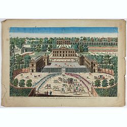
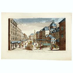
Veuë et Pers-pective de l'Entrée du Château de Marly en général.
A rare panoramic view of the Château de Marly (Marly-le-Roi) by Aveline. The plate, at the joint address of Esnault et Rapilly and Daumont, is numbered in upper right co...
- $250 / ≈ €212
Date: Paris, c. 1760

Nieuwe Paskaart van het Westerlykste Gedeelte van HET KANAAL strekkende aan de ENGELSCHE KUST van Poortland tot de Sorlinges. . .
Nieuwe Paskaart van het Westerlykste Gedeelte van HET KANAAL strekkende aan de ENGELSCHE KUST van Poortland tot de Sorlinges en aan de Fransche kust van het Eylandt Guern...
- $900 / ≈ €765
Date: Amsterdam, 1760

Gesigt van den Vermaakelyken Overtoom ... der stad Amsterdam....
A view of the Overtoom in the eighteenth century. Etching on two joined sheets of paper, after A.Rademaker. By the eighteenth century, numerous country villas had been bu...
Date: Amsterdam, 1760

Pagus Helvetiae Abbatiscellanus .. Valle Rhenana. . .
Scarce. A splendid map of the Swiss Alps, the area south west of the Boden See and west of the River Rhine, centered on Appenzell, St. Gallen. Engraved by Tobias C. Lotte...
- $800 / ≈ €680
Date: Augsbourg, 1760

Belgium Foederatum auctius et emendatius edit..
Map of the northern part of the Netherlands. With a decorative title cartouche, with an inset map of South East Asia.
Date: Augsburg 1760

Vue perspective de la Galerie Royale de Copenhague conduisant au Jardin.
So-called optical print illustrating a perspective view of the Royal Portico in Copenhagen.Mondhare was a well-known publisher of optical prints, established in Paris. In...
Date: Paris 1761

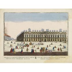
Vue de la superbe Gallerie de Petersbourg en Russie.
So-called optical print illustrates a perspective view of the interior of a palace in Saint Petersburg.Mondhare was a well-known publisher of optical prints, established ...
- $200 / ≈ €170
Date: Paris, 1761

Pianta Geografia delle Isole di Malta, e Gozo della Sagra Religione Gerosolimitana di S. Giovanni delineata, ed incisa in quest anno 1761.
A rare map of Malta and Gozo printed by the priest Antonio Bova (1688 - 1775), who was active as engraver in Palermo ca. 1727-1773. He produced cartographic engravings, s...
Date: Bova Ant., Palermo, 1761
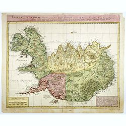
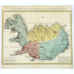
Insulae Islandiae delineatio : prout haec Solenni mensurandi negotio sub Auspiciis Potensissimi Regis Daniae facto . . .
Detailed and important map of Iceland, prepared by Th. H. Knoff and O. Ranzow and published by the Homann Heirs. The map is more scientific than many previous similar ver...
- $850 / ≈ €722
Date: Nuremberg, 1761
Insula Islandiae delineatio. . .
A nice large map of Iceland published by Homann Heirs. The country is divided up into four differently colored regions, lettered title to top of map, boxed mileage scales...
- $900 / ≈ €765
Date: Nuremberg, 1761
Le Comté de Tirol, les Evèchés de Trente et de Brixen..
Detailed map of Austria showing territories of Tyrol, Bavaria, Brixen. Engraved by Cordier.
Date: Paris, 1761
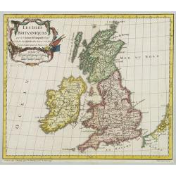
Les Isles Britanniques..
A first state (of 2) dated 1762. Fine map of the British Isles, engraved by E.Dussy. Fine title cartouche upper left engraved by Arrivet. From his Nouvel Atlas Portatif .
Date: Paris, 1762
Carte Hydrographique De La Baye De Cadix. . .
Beautiful chart of the Bay of Cadiz, from Rota to Cadiz, with dramatic coastal topography, soundings, anchorages, forts, loxodromic lines, compass rose and large decorati...
Date: Paris, 1762
![[Mer Baltique]](/uploads/cache/37796-250x250.jpg)
[Mer Baltique]
Detailed map of Northern part of Poland with Danzig, from his "Atlas moderne ou collection de cartes...".map N° 15.
- $300 / ≈ €255
Date: Paris, 1762
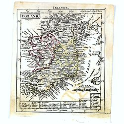
Ireland.
Uncommon miniature map of Ireland, engraved by J. Bayly for "A New General and Universal Atlas Containing Forty five Maps by Andrew Dury".This miniature atlas p...
- $50 / ≈ €42
Date: London, 1761-1763
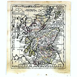
A map of Scotland.
Uncommon miniature map of Scotland, engraved by Thomas Kitching for "A New General and Universal Atlas Containing Forty five Maps by Andrew Dury".This miniature...
- $50 / ≈ €42
Date: London, 1761-1763
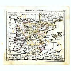
Spain and Portugal.
Uncommon miniature map of Spain and Portugal, engraved by Thomas Kitching for "A New General and Universal Atlas Containing Forty five Maps by Andrew Dury".This...
- $60 / ≈ €51
Date: London, 1761-1763
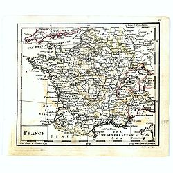
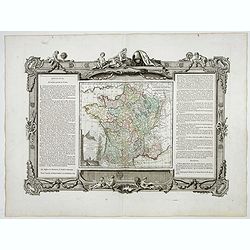
France.
Uncommon miniature map of France, engraved by J.Spilbury for "A New General and Universal Atlas Containing Forty five Maps by Andrew Dury".This miniature atlas ...
- $50 / ≈ €42
Date: London, 1761-1763
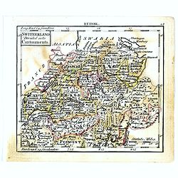
Switzerland divided into Cantonments.
Uncommon miniature map of Switzerland, engraved by Thomas Kitching for "A New General and Universal Atlas Containing Forty five Maps by Andrew Dury".This miniat...
- $30 / ≈ €25
Date: London, 1761-1763
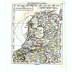
The United Provincies.
Uncommon miniature map of The Netherlands, engraved by J.Ellis for "A New General and Universal Atlas Containing Forty five Maps by Andrew Dury".This miniature ...
- $50 / ≈ €42
Date: London, 1761-1763
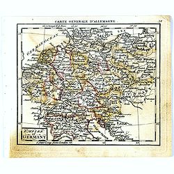
Empire of Germany.
Uncommon miniature map of Germany, Poland, the Low Countries and Eastern Europe, engraved by Thomas Kitching for "A New General and Universal Atlas Containing Forty ...
- $40 / ≈ €34
Date: London, 1761-1763
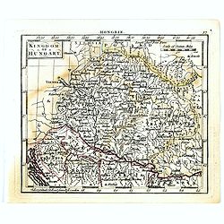
Kingdom of Hungary.
Uncommon miniature map of Hungary, engraved by Thomas Kitching for "A New General and Universal Atlas Containing Forty five Maps by Andrew Dury".This miniature ...
- $75 / ≈ €64
Date: London, 1761-1763
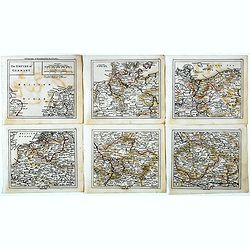
The Empire of Germany.
Uncommon miniature map in six sheets of the Empire of Germany, engraved by Thomas Kitching for "A New General and Universal Atlas Containing Forty five Maps by Andre...
- $75 / ≈ €64
Date: London, 1761-1763
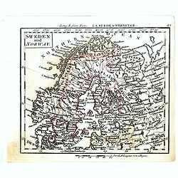
Sweden and Norway.
Uncommon miniature map of Sweden and Norway, engraved by Thomas Kitching for "A New General and Universal Atlas Containing Forty five Maps by Andrew Dury".This ...
- $75 / ≈ €64
Date: London, 1761-1763
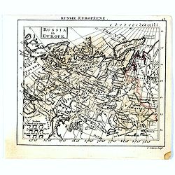
Russia in Europe.
Uncommon miniature map of Russia, engraved by Thomas Kitching for "A New General and Universal Atlas Containing Forty five Maps by Andrew Dury".This miniature a...
- $75 / ≈ €64
Date: London, 1761-1763
![[56] I.Scio.](/uploads/cache/12828-250x250.jpg)
[56] I.Scio.
"Charming chart of the harbour of the Greek town of Chios. Showing town and harbour plan, with soundings, anchorages, rocks, shoals, fortifications and lighthouses.J...
- $80 / ≈ €68
Date: Marseille, 1764
![[59] Svr I. De Paros.](/uploads/cache/12831-250x250.jpg)
[59] Svr I. De Paros.
Charming chart of the harbour of the Greek island of Paros. Showing town and harbour plan, with soundings, anchorages, rocks, shoals, fortifications and lighthouses.Josep...
- $50 / ≈ €42
Date: Marseille, 1764
![[60] Porto de Ganea.](/uploads/cache/12832-250x250.jpg)
[60] Porto de Ganea.
Charming chart of the harbour of the Greek town of Ganea. Showing town and harbour plan, with soundings, anchorages, rocks, shoals, fortifications and lighthouses.Joseph ...
Date: Marseille, 1764

Ajustement des Femmes de Valday Situé entre Petersbourg et Moscou.
Etching by Jean-Baptiste Le Prince (1734-1781), from "2me Suite de divers cris de marchands de Russie", showing typical russian customs. The sketches Le Prince ...
- $110 / ≈ €93
Date: Paris, 1764
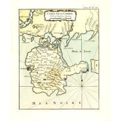
Carte de la Crimée.
Fine map of Crimea (Ukraine) here in the only issue of this version of Bellin's map, slightly larger than the common version. From Bellin's Le Petit Atlas Maritime Recuei...
Date: Paris, 1764

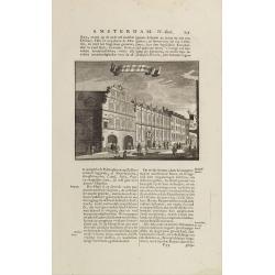
Het stadhuis, van vooren.
The former Amsterdam Town Hall, now the Royal Palace. Copper engraving by Frans de Bakker after Reinier Vinkeles (1741-1816).From the well-known description of Amsterdam ...
Date: Amsterdam, 1765
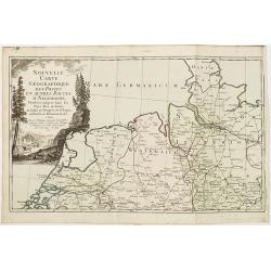
Nouvelle carte géographique des postes et autres routes d'Allemagne. . .
Map showing the northern provinces in Germany and part of the Netherlands. Decorative title cartouche in the upper left corner. A so-called post road maps.
- $80 / ≈ €68
Date: Paris, 1766
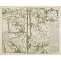
Bataille du Johansberg Gagnée par son Altesse Sérénissime Monseigneur le Prince de Condé . . . Le 30 Aoust 1762 . . .
Five detailed military battle-plans showing the four stages in the siege of Johansburg and the battle plan around Grüningen published by Jean de Beaurain (1696–1771) ....
- $150 / ≈ €127
Date: Paris, 1766
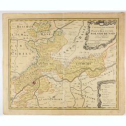
Canton Solothurn sive pagus Helvetiae Solodurensis cum confinibus recenter delineatus per Gabrielem Walserum.
A nice map of Swiss canton centered on Solothurn. Engraved by Tobias C. Lotter.
Date: Augsbourg, 1766
t'Oost-Indisch-Huys.
A decorative print of the East Indian House, the headquarters of the V.O.C., a place for meeting, trading and storage of spices and ship equipment. The maps and charts we...
- $150 / ≈ €127
Date: Amsterdam, 1760-1767
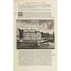
s'Lands en Oost-Indische Lynbanen.
A decorative print of the Lynbanen a place were V.O.C. ship riggings and ropes were produced and kept.From J.Wagenaar: Amsterdam in zijne opkomst, aanwas, geschiedenisse....
- $100 / ≈ €85
Date: Amsterdam, 1760-1767
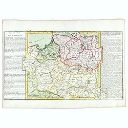
Royaume de Pologne.
Fine map of Lithuania, Prussia and Poland with an explicatif text to both sides. From Jean Baptiste Louis Clouet (1730-1790) influential "Géographie Moderne" f...
Date: Paris, ca. 1767

s'Lands en Oost-Indische Lynbanen.
A decorative print of the Lynbanen a place were V.O.C. ship riggings and ropes were produced and kept.
Date: Amsterdam, 1760-1767

t'Oost-Indisch-Huys.
A decorative print of the East Indian House, the headquarters of the V.O.C., a place for meeting, trading and storage of spices and ship equipment. The maps and charts we...
Date: Amsterdam, 1760-1767

s'Lands en Oost-Indische Lynbanen. & t'Oost-Indisch-Huys.
A decorative print of the Lynbanen a place were V.O.C. ship riggings and ropes were produced and kept.
Date: Amsterdam, 1760-1767
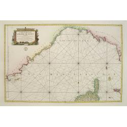
Carte réduite du Golphe de Genes. Conenant partie des cotes de Provence, celles de Piemont, de Genes et de Toscane . . .
Superb sea chart covering the coasts of the French and Italian Riviera's, Tuscany and northern tip of Corsica, prepared by Jacques Nicolas Bellin (1703-1772) the Royal Hy...
Date: Paris, 1768

Vermakelykheden van Brabant, en deszelfs onderhoorige Landen... (2 volumes)
Topographical and iconographical work on Brabant illustrated with 1 engr. title-vignette and 190 engraved views, plans & armorial plates by J. Harrewijn, G. Bouttats ...
Date: Amsterdam, P.J. Entrop, 1768
![[manuscript plan] Siège de Schweidnitz en Silésie fait par les trouppes Imperial es commandées par Mr. le de Nadasti ...](/uploads/cache/39893-250x250.jpg)
[manuscript plan] Siège de Schweidnitz en Silésie fait par les trouppes Imperial es commandées par Mr. le de Nadasti ...
This fine manuscript shows the layout of the city of Swidnica with its surrounding defence wall, its advanced bastions and suburbs, roads and two nearby villages. In lowe...
- $2750 / ≈ €2337
Date: France, 1769

Nouveau théâtre de la guerre entre les Russes les turcs et les polonois confédérés.
A very rare separately published map of Crime region. With a large title cartouche lower left "Nouveau theâtre de la guerre entre les russes, les turcs et les polon...
Date: Paris, 1769
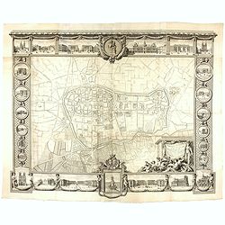
Plan général de Reims et de ses Environs Dédié au Roi.
Rare wall map of a plan of Reims engraved by Jean Lattré. Central cartouche included in the lower border, composed of the coat of arms of France and Navarre, surmounted ...
- $2500 / ≈ €2125
Date: Paris, Lattré, 1769
Tabula Geographica qua pars Russiae Magnae. . .
An unrecorded state Homann's map is based upon the works of George von Mengden (1628-1702), a Livonian cartographer who worked for Peter the Great and Count Jacob Bruce [...
Date: Nuremberg, c. 1770
(Berlin) Prospectus Armamentarii regnii versus arcem principis regis haereditarii Berolini.
A square in Berlin. In the eighteenth and nineteenth centuries there were many popular speciality establishments in Paris, Augsburg and London which produced optical view...
- $200 / ≈ €170
Date: Italy, 1770
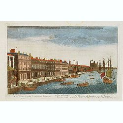
Vue d'optique representant La Douane de Londres sur la Tamise. . .
Showing the Customs office in London seen from the River Thames. Published by Daumont, who was a well-known publisher of optical prints, established in rue St. Jacques in...
- $200 / ≈ €170
Date: Paris, ca. 1770
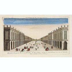
Elevation perspective de la nouvelle place de Petersbourg suivant le projet . . .
Showing a perspective view of the new Palace Square in St. Petersburg. In the 1760s, the Baroque architecture was succeeded by neoclassical architecture.This so-called op...
- $200 / ≈ €170
Date: Paris, ca. 1770
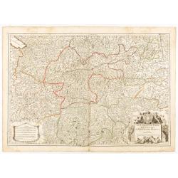
Cercles de Haute-Saxe et de Basse-Saxe.
Early edition of this fine map of the duchies of Saxony (upper & lower), including part of present-day Poland. Published in "Atlas Portatif de Vaugondy".Cha...
- $75 / ≈ €64
Date: Paris, ca.1770
(Hof, Voraths-Magazin, am Fontanka Flus, Zu Petersburg.)
So-called optical print illustrating a perspective view of the river Fontanka in Saint Petersburg. The Fontanka is a branch of the Neva river. At the right of the print w...
- $225 / ≈ €191
Date: Augsburg, c.1770
Vue et Perspective de la Trinité a Vienne.
Decorative perspective view of a square in Vienna centered on the column which represents the Trinity. Published by Jacques François Chereau [1742 -1794], who was active...
- $100 / ≈ €85
Date: Paris, 1770
La France Divisée en ses quarante gouvernemens . . .
Map of France surrounded by a decorative frame.
Date: Paris, 1770
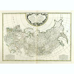
Partie Occidentale de l'Empire de Russie. . . / Partie Orientale de l'Empire de Russie. .
Attractive map of Russia, ornated with a rococo title cartouche. Boundaries outlined in hand color.The detailed map covers from the Baltic Sea to Siberia and the Bering S...
- $400 / ≈ €340
Date: Paris, ca 1771
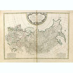
Partie Occidentale de l'Empire de Russie. . . / Partie Orientale de l'Empire de Russie. .
Attractive map of Russia, ornated with a rococo title cartouche. Boundaries outlined in hand color.The detailed map covers from the Baltic Sea to Siberia and the Bering S...
- $200 / ≈ €170
Date: Paris, ca 1771
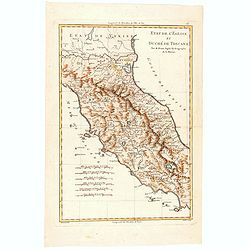
Etat de l'Eglise et Duché de Toscane.
Map of central Italy with Tuscany region by Rigobert Bonne.
- $75 / ≈ €64
Date: Paris, 1771
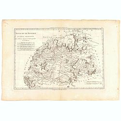
Royaume de hongrie et Pays Adjacents.
Map of the Northern part of the Kingdom of Naples, by Rigobert Bonne.
- $50 / ≈ €42
Date: Paris, 1771
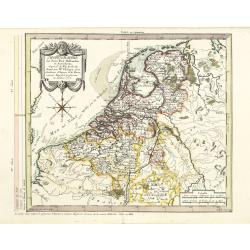
Chorographie des Pays Bas Hollandois et Autrichiens. . .
Fine detailed and uncommon map of the modern Netherlands, Belgium and Luxembourg. Prepared by Etienne André Philippe de Pretot (1708-1787) after sources according to the...
- $200 / ≈ €170
Date: Paris, 1772

(upper sheets only) Asia According to the Sieur D'Anville Divided into its Empires, Kingdoms and States Showing the European Settlements in the East Indies and all the New Discoveries . . . 1772
Highly detailed map of Russia, including Turkey, China and Korea. Based on the cartography of the famous French cartographer Jean Baptiste Bourguignon d' Anville. Only th...
Date: London, 1772