Browse Listings in Europe > Mediterranean & Islands

Tafel der Lender darin der Apostel Paulus geprediget hat.
Rare wood block map depicting the Mediterranean, with an over-sized Cyprus from the final Dutch edition of Heinrich Bünting's famous Itinerarium Sacrae Scripturae, a book...
Date: Magdeburg, 1581
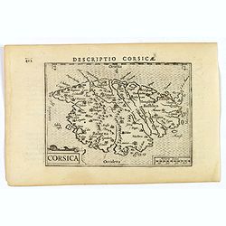
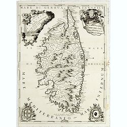
Corsica.
A fine miniature map of the French island of Corsica, published by Petrus Bertius in Amsterdam early in the seventeenth century. The map features a strap-work title carto...
Date: Amsterdam, 1606
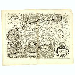
Natoliae Sive Asia Minor.
From the first edition. Map of Turkey, also depicting Cyprus.
Date: Amsterdam, 1606

(Sea-chart of Catalunia, Languedoc, Provence, Cote d'Azur, Riviera, Corsica with Marseille, Cannes, Nice, Monaco.)
This very rare chart is important as the first printed sea chart of France's Mediterranean coast, also depicting Catalunya's northern coast, the Italian Cote d'Azur till ...
Date: Amsterdam, 1607

Hydrograhica descriptio
This very rare chart is important as the first printed sea chart of the Mediterranean coast of Spain, Gibraltar, also depicting the northern coast of Marocco.Willem Bar...
Date: Amsterdam, W.Blaeu, 1612

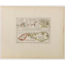
Sardinia / Sicilia.. / Corfu / Zerbi.. / Elba / Malta. . .
Six very fine and early maps on one sheet. Including the islands of Sicily, Corfu, Sardinia, Zerbi (Djerba), Elba and Malta.The map of Malta has a sinking ship at Cala di...
Date: Antwerp, 1570-1612
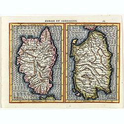
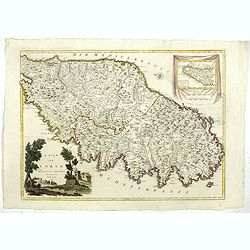
Corsse et Sardaigne.
Maps of Corsica and Sardinia from the rare Cloppenburg edition slightly larger format and more scarce edition of the Mercator/Hondius "Atlas Minor". Engraved by...
- $300 / ≈ €262
Date: Amsterdam, 1630
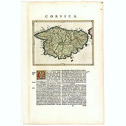
Corsica.
FIRST EDITION, FIRST ISSUE OF THIS MAP. Blaeu's map of the French island of Corsica. East on top. A detailed and well executed map.From an incomplete example of the 1634 ...
- $500 / ≈ €437
Date: Amsterdam, 1634
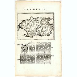
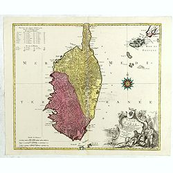
Sardinia Insula.
FIRST EDITION, FIRST ISSUE OF THIS MAP. Map of the Italian island of Sardinia in a copper engraving on a sheet with letterpress with German text description of the island...
Date: Amsterdam, 1634
Romani Imperii Oriens est Descriptio Geographica. . .
A fine map of the Near East. The map was first published by Tavernier and later by Mariette. This edition is dated 1637 with the address of Pierre Mariette at rue S. Jacq...
Date: Paris, after 1637

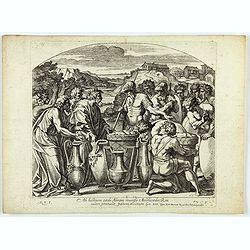
Portantes Arcam sacerdotes . . . (Plate 37)
Very nice etching by Nicolas Chapron, after Raphaël's (Raffaello Sanzio) frescoes in the Vatican Loggia. Scene illustrating Priests carrying the Ark through the River Jor...
- $25 / ≈ €22
Date: Paris, Petrus Mariette, 1649
Cataractae coeli apertoe funt: Et aguae proealuerunt super terram comfumptag Est omnis caro . . . (Plate 13)
Very nice etching by Nicolas Chapron, and after Raphaël's (Raffaello Sanzio) frescoes in the Vatican Loggia. Scene illustrating the moment when God said to Noah "Go ...
- $25 / ≈ €22
Date: Paris, Petrus Mariette, 1649
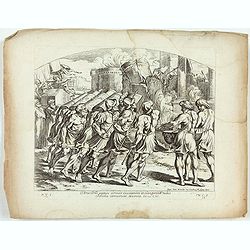
Arca Dni septies circuit Ciuitatem et clangentib tubis. Jericho corruerunt Moenia. Iosue. CVI. ( Plate 38)
Very nice etching by Nicolas Chapron, after Raphaël's (Raffaello Sanzio) frescoes in the Vatican Loggia. Scene illustrating the walls of Jericho crumbling.From the first ...
- $25 / ≈ €22
Date: Paris, Petrus Mariette, 1649
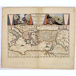
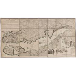
Descriptio Peregrinationis D. Pauli, Apostoli. . .
A striking map of the Mediterranean Sea and its surrounding areas. It depicts the travels of the Apostle St. Paul.The pair of decorative cartouches, presented in a curtai...
Date: Amsterdam, 1650
L'Isle de Malte avec ses Voisines./ La Valete Forte..
Uncommon map Malta. Four maps on one sheet. With inset maps of Valletta.Like Sanson, Briet was born in Abbeville and became a Jesuit at age 18. His "Parallela Geogra...
Date: Paris, 1653

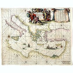
Pascaerte Van't Westelyckste der Middelandsche Zee. . .
An eye-catching chart of the western part of the Mediterranean Sea.Pieter Goos (ca. 1616-1675) was one of the most important cartographer, engraver, publisher and print s...
Date: Amsterdam, 1666

Pascaerte Van't Westelyckste der Middelandsche Zee. . .
An eye-catching chart of the western part of the Mediterranean Sea.Pieter Goos (ca. 1616-1675) was one of the most important cartographer, engraver, publisher and print s...
Date: Amsterdam, 1666
Orientalior districtus Maris Mediterranei.
Beautiful chart of the eastern part of the Mediterranean. Including Italy, the north coast of Africa and part of the Black Sea.The entire sheet is covered with rhumb line...
Date: Amsterdam, 1675
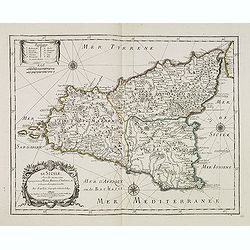
La Sicile, avec les anciens noms de presque toutes ses Places, Rivières, Chateaux &c. et diverses observations nouvelles . . .
Uncommon map of Sicily with fine title cartouche lower right . Original date of 1675 now altered to 1676.More about [+]
Date: Paris, 1676
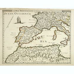
La mer mediterrannée, vers l'Occident. . .
Uncommon map of the western Mediterranean Sea, including France, Spain, Italy, Corsica Sardinia and North Africa. In upper left corner a large sailing vessel.
- $300 / ≈ €262
Date: Paris, 1676
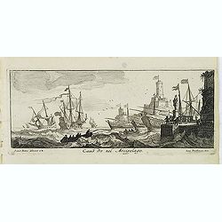
Canistro nel Arcipelago.
Magnificent view of Kanaestreo and its harbour front, decorated with ships and rowing boats in a rough sea. Engraved by Lucas Vostermans II, who was born in 1624, in the ...
Date: Antwerp, c.1690
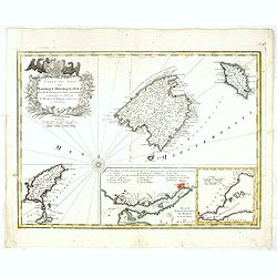
Isola di Corsica, Dedicata all' Em;mo e Rmo: Principe, il Sr. Cardinale Carpegna, Vicario di Sua Santita. . .
One of the most decorative maps of Corsica, with in the upper right, a draped fabric that bears the map's scales is dressed with two angels, one holding the cross, a coat...
Date: Venise, 1692

La mer Mediterranee divisee en ses principales parties ou mers. . .
Very large map centered on the Mediterranean. With a sub title along upper margin "La Mer Mediterranée divisée en Mer de Levant et de Ponant Subdivisées en Leurs Pri...
Date: Amsterdam, c.1705
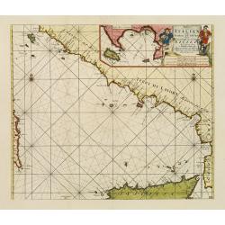
Paskaart der Zeekusten van Italien Tusschen Piombino en C. dell Arme Met de Noord-kust van 't Eylandt Sicilia..
Centered off the Ponziane Islands, this sea chart covers the area of the Tyrrhenian Sea, delimited by Sardinia, the Elba island, the Strait of Messina and Trapani. It con...
- $1000 / ≈ €874
Date: Amsterdam, 1708
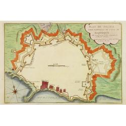
Plan de Palma ville capitalle de l'Isle de Majorque.
Bird's eye-view of Palma de Majorca. Wind rose in the lower left corner. Nicolas de Fer [1646-1720] was one of the most prolific and influential French geographers and ca...
Date: Paris, 1715
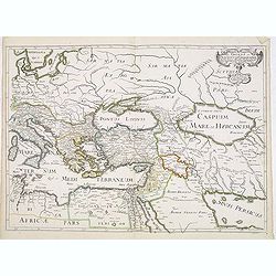
Carte geographique de l'Asie mineure avec un etat des premiers rois. . .
Map of the Mediterranean. This impressive engraving is a wonderful example of Chatelain’s elegant plates from his "Atlas Historique, Ou Nouvelle Introduction A L’His...
- $120 / ≈ €105
Date: Amsterdam, ca. 1720
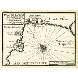
Plan de la Rade de Mayorque.
An attractive chart centered on Palma de Majorca in the Mediterranean. With scale and large compass-rose. Dated 1727, with the privilege of the King. From : Recueil des P...
Date: Marseille, 1730

Carte des Isles de Maiorque Minorque et Yvice dediée A.M. le Comte de Maurepas Ministre et secretaire d'Etat. . .
Fine map of the Baleares with much detail, in lower part inset "Plan du Port de Mahon du Fort St. Philippe et ses Fortifications". The map is dedicated to Jean ...
Date: Amsterdam, after 1740
Carte des Isles de Maiorque Minorque et Yvice.
Uncommon map of Majorca, Minorca and Ibiza prepared by J.N. Bellin. With an inset plan of the harbor of Mahon "Plan du Port et de la Ville de Mahon", and a seco...
- $700 / ≈ €612
Date: Nuremberg, 1756
Plan de la Ville et du Port Mahon et du Fort St. Philippe..
Uncommon folding-map of the fort and town St.Philippe and port Mahon. In upper left corner a key in French (A-Z, Aa-Bb) and a key in Spanish (A-Z, Aa-Oo).A first state. A...
Date: Paris, 1756
L'isle de Corse avec les différents districts, appartenante à la République de gênes . . .
Map published during the uprising of the Corsican people against the Republic of Genoa. It is decorated with a wind rose compass and a beautiful title cartouche decorated...
Date: Augsburg, 1760

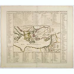
Turquie Européenne, Avec les Pays limitrophes. . .
Copper engraved map centered on Greece, extending northwards and eastwards to include the Balkans and Ukraine as well as Cyprus.The map is flanked by two columns of Frenc...
- $50 / ≈ €44
Date: Paris, 1790
L'Isle de CORSE Divisée en ses departemens.
Nice map of Corsica, with a decorative cartouche in the left low corner. Small inset map of Sicily in the upper right corner: "Pointe de Capo Corso".This is the...
Date: Venise,1805
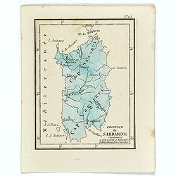
Province de Sardaigne.
Province de Sardaigne Contenant 9 Col. 1 Sem. 1 Noviciat, 2 Résidences 300 Jésuites". Publiée dans "Atlas Universel indiquant les établissemens des Jésuites: av...
Date: Paris, Ambroise Dupont , 1826
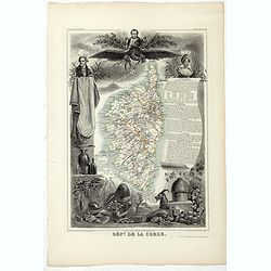
Dépt. De La Corse. N°19.
Map of the Corsica island.Lovely map from one of the last decorative atlases of the nineteenth century.The rather simple map is framed by elaborate border showing regiona...
Date: Paris, A. Combette, 1852
![[Map of Turkey in Ottoman script]](/uploads/cache/40765-250x250.jpg)
[Map of Turkey in Ottoman script]
Map of Turkey, including Cyprus, with text in Ottoman script. In the bottom a color key to the different regions. Published by Elbemühl Graphische Industrie in Vienna (fo...
Date: Vienna, ca. 1915
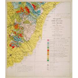
Mapa geologic de les serres de Llevant de l'illa de Mallorca.
Geological map showing part of the island Mallorca Felanitx, Santanyi, Porto Cristo, Porto Colom.., including a legend with geological and topographical signs. After a de...
- $100 / ≈ €87
Date: Palma, 1932
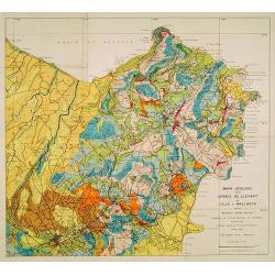
Mapa geologic de les serres de Llevant de l'illa de Mallorca.
Geological map showing part of the island Mallorca Manacor, Son Severa, Capdepera.. After a design by D.Ferrá. Dibuxá, in lower right corner: D.Ferrà. Dibuxá.Provenance :...
- $150 / ≈ €131
Date: Palma, 1932
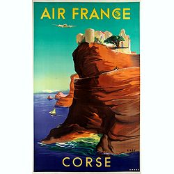
Air France - Corse.
Corsica poster for Air France, by Raoul Éric Castel (1915 - 1997) and published by Havas. Signed has work with Éric, he was born in Lyon and made many fine travel posters...
Date: Imprimerie Perceval Paris, ca. 1940-1950
