Browse Listings in Europe
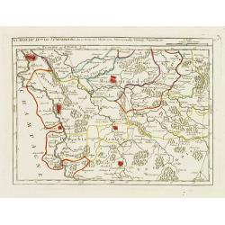
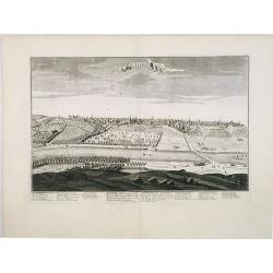
X. Carte du D.ché de Luxembourg.. Jametz &c.
Nice small map encompassing the northwestern part of Lorraine. Showing Mouzon, Stenay, Montmedy..From Atlas Portatif Universel, by Robert de Vaugondy. Edited by : "A...
Date: Paris, later than 1749
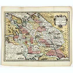
![[IX.] Carte du Brabant ou sont les Mairies de Roo, de Nivelle, de Hulpen, et de Geneppe.](/uploads/cache/24689-250x250.jpg)
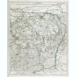
[IX.] Carte du Brabant ou sont les Mairies de Roo, de Nivelle, de Hulpen, et de Geneppe.
Nice small map straddling the Flemish and the Walloon regions. It shows Halle, Nivelles, La Hulpe, Overijse, Genappe, etc.From Atlas Portatif Universel, by Robert de Vaug...
Date: Paris, later than 1749
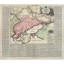
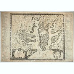
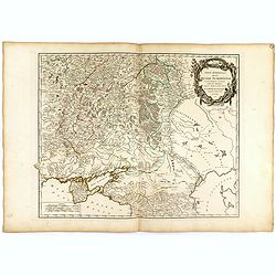
Estats du Grand duc de Moscovie ou de l'Empereur de la Russie Blanche.
Uncommon map of European Russia centered on Muscovy. Charming title cartouche in upper right corner.
- $300 / ≈ €255
Date: Amsterdam, ca 1749
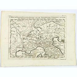
A Map of Gallia, Cisalpina, Liguria and the Neighbouring Countries.
A map of eastern France, Provence, northern Italy, then to Tuscany, whilst also showing northern Switzerland and Bavaria in Roman times. Showing Roman Provinces, a mileag...
- $50 / ≈ €42
Date: London, ca 1749

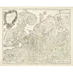
Transisalania vulgo Over-Yssel auct. N. ten Have. . .
Map of the central part of the Netherlands, prepared by N. ten Have with a decorative cartouche lower left.Joachim Ottens (1663 - 1719) and his sons Renier and Joshua wer...
Date: Amsterdam, ca. 1750
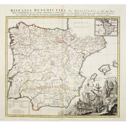
Hispania Benedictina, seu Monasteria et alia pia loca Ord. S. Benedicti ..
Map of the Iberian Peninsula and an inset map of South America with all the monasteries and holy places of the Benedictine order, compiled by the Benedictine friar Rupert...
Date: Nuremberg 1750
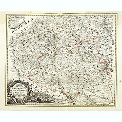
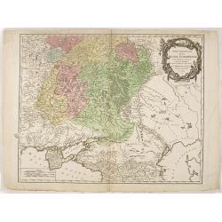
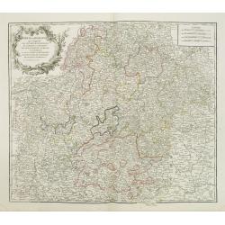
Marchionatus Moraviae circuli Znoymensis et Iglaviensis. . .
Map of the Znaym region of Moravia, the southern part of the Czech Republic, with figurative cartouche and small table of explanations. After Johann Christoph Müller pub...
- $250 / ≈ €212
Date: Nuremberg, 1750
![Chambery / Turo / Coucy le Chateau. . . [5 prints]](/uploads/cache/14386-250x250.jpg)
Chambery / Turo / Coucy le Chateau. . . [5 prints]
A set of 5 prints. A nice view of Chambery: in Savoie; a charming view of Coucy le Chateau, engraved by Picquenot; a very fine plan of Tours, including a lettered key on ...
Date: Paris, 1580 -1750
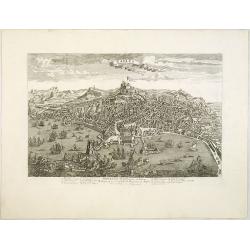
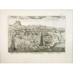
Naples, Ville de la Province de Labour, Archiépiscopale, et Capitale du Royaume de Naples.
A very decorative and extremely rare view of Naples, including a numbered (1-18) key in the lower part. Published by Jacques Chéreau, (1688 - 1776). Engraved by Aveline ...
- $3500 / ≈ €2975
Date: Paris, ca.1750
Seville. Ville Archiepiscopale et Capitale du Raume d'Andalousie en Espagne. . .
A very decorative and extremely rare view of Seville, including a numbered (1-37) key in the lower part. Published by Jacques Chéreau, (1688 - 1776). Engraved by Aveline...
- $2200 / ≈ €1870
Date: Paris, ca.1750

Middelbourg Ville la plus considerable de l'Isle de Walcheren et du Comté de Zelande l'une des huit provinces Unis des pais-bas . .
A very decorative and extremely rare of Middelburg, including a numbered (1-19) key in lower part. Published by Jacques Chéreau, (1688 - 1776). Engraved by Aveline and ...
Date: Paris, ca.1750
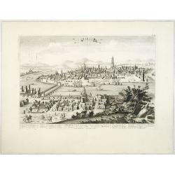
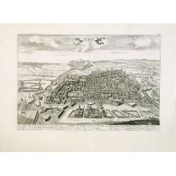
Messine. Anciennement Messena Ville . . .
A very decorative and extremely rare view of Messina on Sicily, including a numbered (1-16) key in lower part. Published by Jacques Chéreau, (1688 - 1776). Engraved by A...
- $3000 / ≈ €2550
Date: Paris, ca.1750
Barcelone, Ville Capitale de la principauté Catalogne. . .
A very decorative and scarce view of Barcelona, including a numbered key ( 1-29 ) in the lower part. Published by Jacques Chéreau, (1688 - 1776). Engraved by Aveline and...
- $4000 / ≈ €3400
Date: Paris, ca.1750

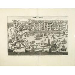
Amsterdam Ville du Comté de Hollande et la plus considerable des Provinces Unies. . .
A very decorative and extremely rare town-view of Amsterdam, including a numbered (1-18) key in lower part. Extensive shipping on the IJ. To the left the headquarters of ...
Date: Paris, ca.1750

A view of Westminster bridge. Vue du pont Westminster.
A very decorative and extremely rare of river Themes and Westminster bridge in London, including a six-line description in French and English. Published by Jacques Chér...
Date: Paris, ca.1750
Rome. Profil de la Ville de Rome.
A very decorative and extremely rare town view of Rome, including a numbered key ( 1-47 ), in lower part. The Vatican with St.Pierre in the left, with great detail. Publ...
- $3300 / ≈ €2805
Date: Paris, ca.1750
Milan. Ville forte, Capitale du Duché de même nom, l'une des plus grandes des des plus considérables de l'Italie.
A very decorative and extremely rare of Milan, including a numbered key ( 1-35 ) in lower part. Published by Jacques Chéreau, (1688 - 1776). Engraved by Aveline and fir...
- $3500 / ≈ €2975
Date: Paris, ca.1750
Turin. Ville Capitale du Piemont et Residence du Duc de Savoye Roy de Sardigne.
A very decorative and extremely rare town-view of Turin, including a numbered key ( 1- 28 ) in lower part. Published by Jacques Chéreau, (1688 - 1776). Engraved by Pierr...
- $2500 / ≈ €2125
Date: Paris, ca.1750
Madrid Villa Capital Del Reyno D'Espana.. / Madrid ville capitale du Royaume d'Espagne . . .
A very decorative and scarce town view of Madrid, including a numbered key ( 1-17 ) in Spanish and French in the lower part. Published by Jacques Chéreau, (1688 - 1776)....
- $3300 / ≈ €2805
Date: Paris, ca.1750

Porte de Harlem (Heemstede/Haarlem)
Showing the Haarlemmer Poort (gate) in Heemstede near Haarlem. Likely published by Mondhard, who was a well-known publisher of optical prints, established in rue St.Marti...
Date: Paris, ca. 1750

Vue générale d'Amsterdam.
A so-called optical prints, showing Amsterdam seen from the IJ. A lively scene with extensive shipping. To the left the headquarters of the V.O.C., nowadays the Maritime ...
Date: Paris, ca. 1750

Vue du village de Maarsen en Hollande.
Showing the river Vecht at the town of Maarsen. Published by Jacques Chereau, who was a well-known publisher of optical prints, established in rue St. Jacques in Paris. I...
Date: Paris, ca. 1750

Perspective du Voorhout, promenade publique de La Haye.
Showing the Voorhout in The Hague. Likely published by Mondhard, a well-known publisher of optical prints, established on rue St. Martin in Paris. In the eighteenth and n...
Date: Paris, ca. 1750
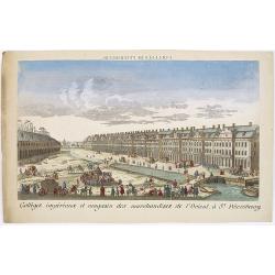
Colléges impériaux et magasin des marchandises de l'Orient, à St. Pétersbourg.
Showing a busy scene at the international trading grounds of 18th century Saint Petersburg, showing the warehouses of the different international trading companies. J. Ch...
- $200 / ≈ €170
Date: Paris, ca. 1750
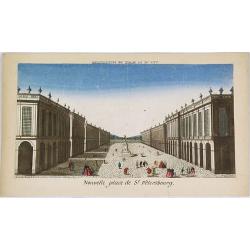
Nouvelle place de St. Pétersbourg.
Showing a square at 18th century Saint Petersburg. J. Chereau was a publisher of optical prints, established in Paris, rue St.Jacques.In the eighteenth and nineteenth ce...
- $200 / ≈ €170
Date: Paris, ca. 1750
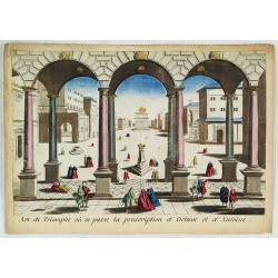
Arc de Triomphe ou se passe la proscription d'Octave et d'Antoine.
J. Chereau was a publisher of optical prints, established in Paris, rue St.Jacques.In the eighteenth and nineteenth centuries, there were many popular specialty establish...
- $200 / ≈ €170
Date: Paris, ca. 1750

Les Villes forts et châteaux de Malte capitale de l'isle de ce nom. Dessignée sur le lieu par un Ingr du roy.
A very decorative and extremely rare town-view of Valetta, including a numbered legend in lower part. Published by Jacques Chereau, (1688 - 1776). Engraved by Aveline and...
Date: Paris, ca.1750
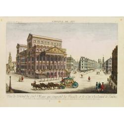
Vue de l'Hotel du Lord Maire, qui comprend.. (London)
In the eighteenth and nineteenth centuries there were many popular speciality establishments in Paris, Augsburg and London which produced optical viewing devices and spec...
- $300 / ≈ €255
Date: Augsburg 1750
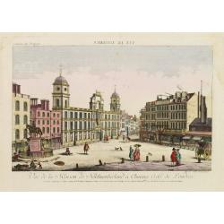
Vue de la Maison de Northumberland a Charing Cross. . .
In the eighteenth and nineteenth centuries there were many popular speciality establishments in Paris, Augsburg and London which produced optical viewing devices and spec...
- $300 / ≈ €255
Date: Augsburg 1750
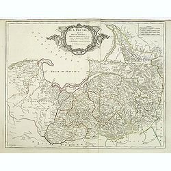
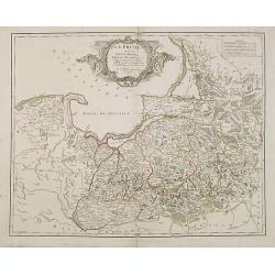
La Prusse divisée en Prusse royale, et Prusse Ducale. . .
Finely and crisply engraved map of Prussia including The Bay of Danzig. Ornamental title cartouche in the upper part of the map from his "Atlas Universel".Gille...
- $300 / ≈ €255
Date: Paris, 1750
Principatus Halberstadiensis, abbat : Quedlinburgens cum Comitatu Wernigerodano, ad hodiernum verum statum ex acta prodiit ex officina geogr. . .
Detailed map showing principality Halberstadt, Abtei Quedlinburg and the county Wernigerode. Including the towns of Osterwieck, Stollberg, Aschersleben and Oschersleben.
Date: Augsburg, 1750

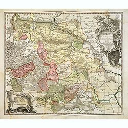
Dynastiae Comitat. Schoenburgici Penig, Remissa, Rochsburg, Wechselburg In Clientela Elect: Saxon Glaucha, Hartenstein, Lichtenststein, Walkenburg. . .
A very uncommon and superbly decorative map of Lower Saxony, the region southwest of Dresden. Including the towns of Rochlitz, Geringswalde, Mittweida, Frankenberg, Chemn...
Date: Augsburg, 1750
Electoratus saxonici praefecturae annaburgensis pretzschens torgaviensis schweinicensis. . .
Highly detailed map showing the regions of Annaburg, Pretzsch, Schweinitz in Sachsen-Anhalt, Torgau in Sachen and Mühlberg an der Elbe in Brandenburg. In the center of t...
Date: Augsburg, 1750

Vue du village de Maarsen en Hollande.
Showing the river Vecht at the town of Maarsen. Published by Jacques Chereau, who was a well-known publisher of optical prints, established in rue St. Jacques in Paris. I...
Date: Paris, ca. 1750
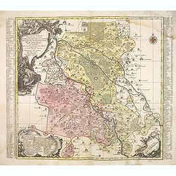
Vue perspective du palais episcopal de Westminster.
So-called optical print illustrating a perspective view of the old Palace of Westminster where the Lords and Commons met and the square facing it.. Published by Jacques C...
- $150 / ≈ €127
Date: Paris, ca. 1750
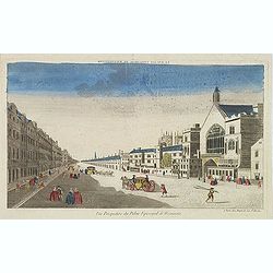
Vue de la Place de St Marc de Venise du côté du port.
Optical print showing the Doge's Palace (Palazzo Ducale), San Marco Square, and Saint Mark's Basilica (Basilica di San Marco in Venice, as seen from the waterside. The im...
Date: Paris, ca. 1750

Vue perspective edu fauxbourg et du port de Scheveningue a une lieue de la Haye, en Hollande.
Optical print showing the village and harbor of Scheveningen with the church at the right, in the background the North Sea. In the background, the summer residence Nieuw ...
Date: Paris, ca. 1750
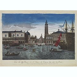
Vue perspective de la prison royale de Madrid en Espagne . . .
So-called optical print of the Royal Prison, now the Ministry of Foreign Affairs in Madrid. Published by Jacques Chereau, who was a well-known publisher of optical prints...
- $200 / ≈ €170
Date: Paris, ca. 1750
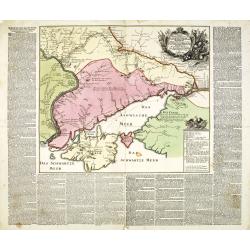
Charte der Kriegs Operationen am Donn u: Dnieper Ihro Russisch Kayserl Majestaet Glorieusen Armeen A: 1736.
Very rare separately published map of the southern part of Ukraine, with an explanatory key A-N in the lower right. The map is surrounded by letterpress German text givin...
Date: Augsburg, 1750
Vue de l'Entree de la Cour.. de la rue de l'Arno a Florence
So-called optical print of Arno Street in Florence, in Tuscany region. Probst was the best-known publishers of optical prints, established in Augsburg.In the eighteenth ...
- $150 / ≈ €127
Date: Augsburg 1750
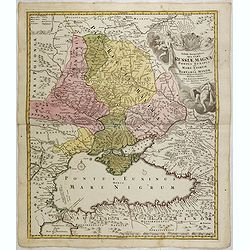
Tabula Geographica qua pars Russiae Magnae. . .
Homann's map is based upon the works of George von Mengden (1628-1702), a Livonian cartographer who worked for Peter the Great and Count Jacob Bruce [Graf Jakov Villimovi...
Date: Nuremburg, after 1750
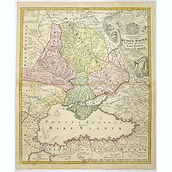
Tabula Geographica qua pars Russiae Magnae Pontus Euxinus seu Mare Nigrum et Tartaria Minor.
Homann's map is based upon the works of George von Mengden (1628-1702) a Livonian cartographer who worked for Peter the Great and Count Jacob Bruce [Graf Jakov Villimovic...
- $750 / ≈ €637
Date: Nuremburg, after 1750
Le Brabant. Ou la Campagne du Roy de 1746. . .
Uncommon map of Dutch and Belgium Brabant by George Louis Le Rouge, who was active from 1740- till 1780 as a publisher and was appointed engineer for the King of France.D...
- $300 / ≈ €255
Date: Paris, ca. 1750
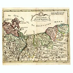
Das Hertzogthum Pommern.
Very rare map of Pomerania engraved by Johann David Schleuen (1711-1771) who was an publisher and engraver active in Berlin. He is known for his "General-Carte des g...
- $750 / ≈ €637
Date: Berlin, ca. 1750
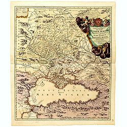
Tabula Geographica qua pars Russiae Magnae Pontus Euxinus seu mare Nigrum et Tartaria Minor cum finitimis Bulgariae, et Romaniae et Natoliae. . .
Homann's map is based upon Beauplan's general map of Ukraine but depicts the political changes of the preceding years. Shows Constantinople. Extends north to Moscow and S...
Date: Nuremburg, 1750
Imperium Moscoviae.
Map of the empire of Moscovia
- $300 / ≈ €255
Date: Nuremberg, 1750
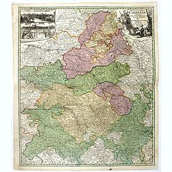
Tabula Geographica Campaniae. . .
Map of the Champagne region with Rheims, Châlons, Vitry in the center. In upper left corner two inset views with the towns of Reims et Troyes.
- $225 / ≈ €191
Date: Nuremberg, ca. 1750

Vue de l Hotel du Lord Maire, qui comprend la Façade, et le Cot' Occidental de Londres.
Shows the famous Lord Mayor's coach driving through London. The Lord Mayor's coach is famous for its role in the Lord Mayor's Show, which is one of the longest establishe...
- $100 / ≈ €85
Date: Augsburg, 1750
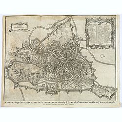
Ghent a large City and Castle in Flanders. . .
A very fine bird's-eye plan of the city and fortifications of Ghent and the surrounding countryside in Belgium. A decorative cartouche encloses a detailed key to the map ...
- $100 / ≈ €85
Date: London, ca 1750
![Plan de Mons ville capitale du comté de Haynaut. [MONS]](/uploads/cache/39799-250x250.jpg)
Plan de Mons ville capitale du comté de Haynaut. [MONS]
Charming little plan of the city of Mons in Belgium, engraved by Inselin, with a lettered key (A-V) in lower right corner.
Date: Paris, 1750
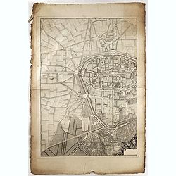
![La ville et citadelle d'Anvers. [Antwerp]](/uploads/cache/39843-250x250.jpg)
La ville et citadelle d'Anvers. [Antwerp]
A town-plan of the fortified enclosure of Antwerp with its citadel, showing the extensions made between 1201 and 1701, when the fortifications were enlarged by Philippe V...
- $225 / ≈ €191
Date: Paris, ca. 1750
![[OSTENDE] A new and exact Plan of the city and port of Ostend.](/uploads/cache/39849-250x250.jpg)
[OSTENDE] A new and exact Plan of the city and port of Ostend.
Nice plan of the city of Ostend and Fort Philippe, engraved by R. Benning. In upper left corner "A map of part of Flanders shewing the country and sands about Ostend...
- $300 / ≈ €255
Date: Paris, ca. 1750

Nieuwe en zeer accuraate Zee-Caart van de Hollandse Wal strekkende van de Maas tot Texel opgenomen door Jan Rokusz Douw, , ,
A very fine and rare chart of the coast of Holland, Prepared by Jan Rokusz, Douw and Agge Roskam Kool.Embellished with a very decorative cartouche with a dedicational tex...
Date: Amsterdam, 1750
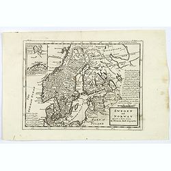
Sweden and Norway.
Herman Moll's mid eighteenth century map of Sweden and Norway, extending down to Denmark, across to Finland, and south to the Baltic states of Estonia, Livonia etc. With ...
- $125 / ≈ €106
Date: London, ca 1750

Carte particuliere des costes de Poittou, Aunis et de la Rochelle.
Finely designed and rare map of Isle Ré and the French coast with La Rochelle.
- $1250 / ≈ €1062
Date: Amsterdam, c. 1750
Charte der Kriegs Operationen am Donn u: Dnieper Ihro Russisch Kayserl Majestaet Glorieusen Armeen A: 1736
Scarce separately published map of the southern part of Ukraine, with an explanatory key A-N in the lower right. The map is surrounded by letterpress German text giving a...
Date: Augsburg, 1750
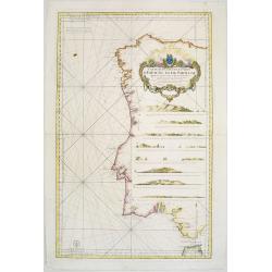
Carte Réduite Des Costes D'Espagne Et De Portugal Depuis le Cap Pinas jusqu'au Détroit de Gibraltar..
Large-scale sea chart covering all of the coast of Portugal, with eight coastal profile insets.The chart was engraved by Herman van Loon. With rhumb lines.Published by th...
- $500 / ≈ €425
Date: Paris, 1751
La Prusse divisée en Prusse Royale et Prusse Ducale. . .
Finely and crisply engraved map of Prussia including The Bay of Danzig. Folio map by Giles Didier Robert De Vaugondy.Ornamental title cartouche in the upper part of the m...
- $350 / ≈ €297
Date: Paris, 1751
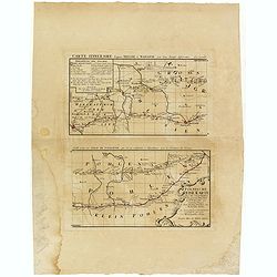
Polnische Reise Karte uber die vornehmsten Passagen von Dresden nach Warschau auf zweyerley Wegen I) uber Breslau, Peterkau und II) uber Lissa, Kaliez . . . 1751
Scarce strip-style road map showing two roads from Dresden via Glogau or Breslau to Warsaw.A key identifies villages, markets and post offices along the routes. Printed i...
Date: Nurember, 1751

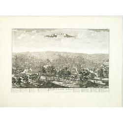
Vue et perspective de la ville de Marseille et ses environs, prise du côté de la belle vue de la plaine St. Michel. Dediée à S. A. S. Mgr. le duc de Penthievre Grand Amiral de France. Par son très humble et très obéissant Serviteur Aulagnier.
Scarce large and spectacular panorama of the city and harbour of Marseille published in Paris in the middle of the 18th century. Engraved by Pierre Jacques Duret under th...
Date: Paris, 1751
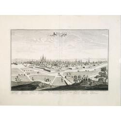
Plan général de la ville capitale de Malte dressé sur les memoires des grands officiers de l'Ordre, dédiée et présentée à S.A.S. Mgr le prince de Conty, prince du sang, grand prieur de France. . .
First edition of this attractive large scale plan of Valetta on Malta. To the left and right a numbered key 1 - 269. In lower left, a title cartouche with a dedication to...
Date: Paris, 1751
Partie Méridionale de la Russie Européenne. . .
Detailed map of Ukraine, the Crimea and the northern part of the Caspian Sea.
Date: Paris, 1752
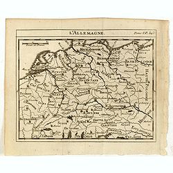
L'Allemagne.
Scarce small map of Germany, Poland and Low Countries based on cartography of Guillaume Delisle (. Published in "Nouveau traité de geographie par M**** ", publ...
- $50 / ≈ €42
Date: Paris, 1752
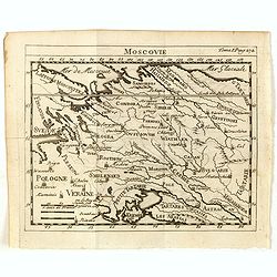
Moscovie.
Scarce small map centered on Muscovy and based on cartography of Guillaume Delisle (. Published in "Nouveau traité de geographie par M**** ", published by La v...
- $50 / ≈ €42
Date: Paris, 1752
Partie méridionale de la Russie Européenne. . .
Detailed map of Ukraine and the Crimea. In lower right corner inset map of Cosaques. From his "Atlas Universel".Gilles Robert de Vaugondy (1688–1766), also kn...
Date: Paris, 1752
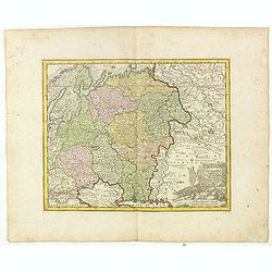
Cercle de Franconie . . .
Finely and crisply engraved map of part of Germany. Map by Giles Didier Robert De Vaugondy with erased title cartouche. Ornamental title cartouche in the upper part of ma...
- $50 / ≈ €42
Date: Paris, 1752
Partie Septentrionale de la Russie Européenne . . .
Detailed map of European part of Russia, including Finland, Lapland.
Date: Paris, 1753

A View of S. James's Palace Pall Mall. - Vues du Palais royal de S.Jacques Pall Mall.
So-called optical print illustrating a perspective view of St James's Palace, Pall Mall. The gatehouse of St James's Palace is on the left.In the eighteenth and nineteent...
Date: Paris, 1753
Paskaart Vande Noord Cust van Schotland als mede de Eylanden van Hitland en Fero. . .
Decorative chart, with south to the top. Latitude scale, compass rose and system of rhumb lines, soundings, anchorage's, etc. In the lower right corner, with added number...
- $500 / ≈ €425
Date: Amsterdam, 1753

Russie Européenne . . .
Detailed map of European part of Russia, including Finland and Lapland.Gilles Robert de Vaugondy (1688–1766), also known as Le Sieur or Monsieur Robert, and his son, Di...
Date: Paris, ca. 1753
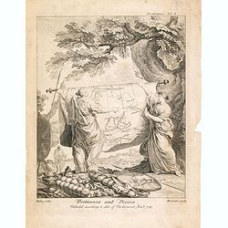
Britannia And Persia.
A finely engraved and unusual depiction of Britannia and Persia, two women with spears and shields holding a map between them. This map depicts a route through the Baltic...
- $800 / ≈ €680
Date: London, 1753
Partie Septentrionale de la Russie Européenne . . .
Detailed map of European part of Russia, including Finland, Lapland.
- $100 / ≈ €85
Date: Paris, 1753
Troisième partie de la carte d'Asie, contenant la Sibérie, et quelques autres parties de la Tartarie. . .
Engraved map of Tartary on two sheets, with country boundaries in outline color. Includes geographic notes and ornamental cartouche by "H. Gravelot, invenit., DeLafo...
Date: Paris, 1753
Veduta della Chiesa e Piazza d'Ognissanti.
Lively view of Piazza Ognissanti in Florence after Giuseppe Zocchi (1711or 1717 - 1767) and engraved by Giuseppe Papini. From "Scelta di XXIV Vedute delle principali...
Date: Florence, Bouchard, 1754
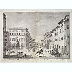
Veduta del Palazzo del Sig.re Marchese Strozzi, del Centauro e della Strada che conduce a S. Maria Novella.
Lively view of a square with the Palace of the Marquis Strozzi of Florence after Giuseppe Zocchi (1711or 1717 - 1767) and engraved by B.Sgrilli. From "Scelta di XXIV...
Date: Florence, Bouchard, 1754
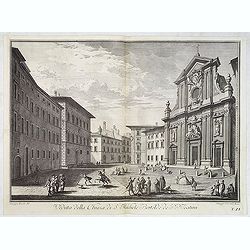
Veduta della Chiesa di S. Michele Bertelde de' PP. Teatini.
Lively view of a square with the Church of Santi Michele e Gaetano in Florence after Giuseppe Zocchi (1711or 1717 - 1767) and engraved by B.Sgrilli. From "Scelta di ...
Date: Florence, Bouchard, 1754
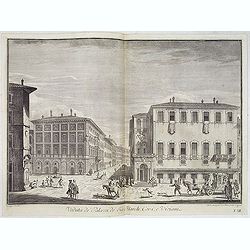
Veduta de' Palazzi de' Sig. March. Corsi e Viviani.
Lively street scene with several palaces in Florence after Giuseppe Zocchi (1711or 1717 - 1767) and engraved by Mich. Mariesschi and Vincenzo Francesschini. From "Sc...
Date: Florence, Bouchard, 1754
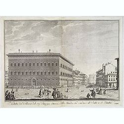
Veduta del Palazzo del Sig.re Principe Strozzi, e della strada che conduce al Ponte a S. Trinita.
Lively street scene with the palace of Mr. Strozzi in Florence after Giuseppe Zocchi (1711or 1717 - 1767) and engraved by Bal. Gabbuggiami from Rome. From "Scelta di...
Date: Florence, Bouchard, 1754

Veduta della Piazza della SS. Nunziata, Statua Equestre di Ferdinando Primo, Fonti, e Loggie Laterali.
Lively view of Nunziata square with the statue of Ferdinand I in Florence after Giuseppe Zocchi (1711or 1717 - 1767) and engraved by B.Sgrilli. From "Scelta di XXIV ...
Date: Florence, Bouchard, 1754