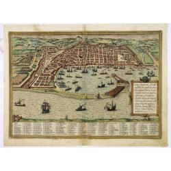
![Venecie. [Venice] Foliu XLIIII.](/uploads/cache/49420-250x250.jpg)
Venecie. [Venice] Foliu XLIIII.
A very fine panoramic view of Venice (192x525mm.) Verso a view of Padua. Schedel's view of Venice is one of the earliest obtainable views of the city. The view is based o...
Date: Nuremberg, 12 July 1493
![Venecie. [Venice] Foliu XLIIII](/uploads/cache/29716-250x250.jpg)
Venecie. [Venice] Foliu XLIIII
A very fine of Venice (192x525mm.) Verso a view of Padua. Schedel's view of Venice is one of the earliest obtainable views of the city. The view is based on the view of ...
Date: Nuremberg, 12 July 1493
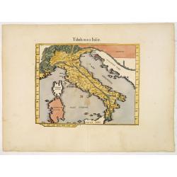
.Tabula nova Italiae. (Modern Italy)
Wood block printed modern map of Italy, prepared by Lorenz Fries and one of the earliest modern maps of Italy and environs. Based on the slightly larger map from 1513 pub...
Date: Vienna, 1525 -1541
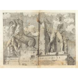
Opus Praxitelis, Opus Fidiae.
Opus Praxitelis, Opus Fidiae [Work of Praxiteles, Work of Fidias]. With the Lafreri's imprint and date. Published in the "Speculum Romanae Magnificentiae" (The ...
Date: Rome, Antonio Lafreri, 1546

Equitum in Quirinali, aversa parte, marmorei colossi Romae; absolutissima Praxitelis et Fidiae manu.
Back view of the Dioscuri (or horse tamers, or Alexander and Bucephalus), formerly attributed to Pheidias and Praxiteles, with two figures nearby, one seated on a stone, ...
Date: Rome, Antonio Lafreri, 1550
![[Toscana / Tuscany] En, candidi lectores, elegantioris Italiae partis, Tusciae scilicet, topographiam. aenis nris formis excussam in hac Tabella vobis denuo damus. . .](/uploads/cache/47717-250x250.jpg)
[Toscana / Tuscany] En, candidi lectores, elegantioris Italiae partis, Tusciae scilicet, topographiam. aenis nris formis excussam in hac Tabella vobis denuo damus. . .
A rare map of Tuscany, including the islands of Elba, Giglio, Giannutri and part of Corsica, and covering the whole of Tuscany, part of Liguria, Lombardy, Emilia, Umbria,...
Date: Rome, ca 1557
![Amphitheatri Veronen[sis] diligens et accurata delineatio…](/uploads/cache/49136-250x250.jpg)
Amphitheatri Veronen[sis] diligens et accurata delineatio…
The print features the Amphitheater of Verona, it comes from "Speculum Romanae Magnificentiae" (The Mirror of Roman Magnificence). Example of the first state of...
Date: Rome, Antonio Lafreri, ca. 1560
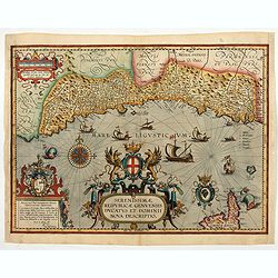
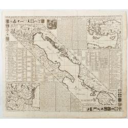
![IL GOLFO DI VENETIA [Gulf of Venice].](/uploads/cache/49393-250x250.jpg)
IL GOLFO DI VENETIA [Gulf of Venice].
IL GOLFO DI VENETI A si come è il più famose et jllustre di quanti sono dal Mare inondati, cosi dovendo uscire al mondo nelle mie stampe piu copioso di quanti fin hora so...
Date: Venice,1568

Castello Sancto Angelo di Roma.
The print features the Castello Sant' Angelo in Rome, bound in an album, perhaps from the "Speculum Romanae Magnificentiae." Copper engraving and published by A...
Date: Rome, Antonio Lafreri, ca. 1573
![Naumaohiae [sic] id est navalis pugnae ex vetusteis lapidum et nummorum monumenteis graphica deformatio.](/uploads/cache/49142-250x250.jpg)
Naumaohiae [sic] id est navalis pugnae ex vetusteis lapidum et nummorum monumenteis graphica deformatio.
Naval engagement set inside an arena, spectators in the stands attending the event; reclining river god and nymphs in the lower part. From "Speculum Romanae Magnific...
Date: Rome, ca. 1575
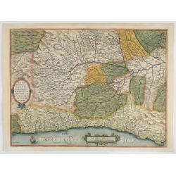
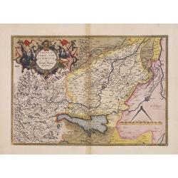
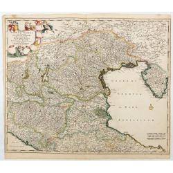
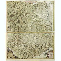
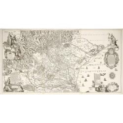
Pedemontanae Vicinorumque Regionum.
Fine map including the Italian coast from Monaco till Genoa. Milan in the upper righthand corner and Turin in the center of the map.
Date: Antwerp, 1574-1575
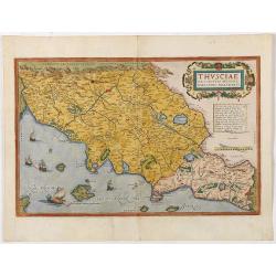
Thusciae Descriptio Auctore Hieronimo Bellarmato.
Decorative and detailed map of Tuscany, from the 1574 or 1575 Latin text edition of Ortelius' Theatrum Orbis Terrarum, the first modern atlas of the world. The map is bas...
Date: Antwerp, 1574-1575
Messana, Urbs est Sicilie maxima, situ, opulentia, & tuta navium statione.
Very desirable and early town-plan of Messina on Sicily, with a numbered key (1-167) in lower part. "Messina is shown from the east, in a view looking down upon the ...
Date: Cologne, (1572) 1577
Veronae Urbis Territorium.
Very fine map of part of Italy centered on Verona, Vizenza and Lake Garda. Prepared by Bernardino Brugnoli, which first was published in 1574 by Forlani. Ortelius' map is...
Date: Antwerp, 1584
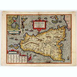
Siciliae Veteris Typus.
A very beautiful early map of ancient Sicily. Title cartouche centered on the upper part: includes also an inset map of Syracuse in the upper left, and a list of the town...
- $600 / ≈ €525
Date: Antwerp, 1587

Latium.
Based on classical authors' sources, specifically Virgilius, Plinius, Varro, Halicarnasseus, Festus and Ausonius.Philip Wingius in his letter to Ortelius from 1592 mentio...
Date: Antwerp, 1595
![[ View of Ragusi]](/uploads/cache/45206-250x250.jpg)
[ View of Ragusi]
Very rare view of Ragusa published in the first edition of "Viaggio da Venetia, a Costantinopoli. Per Mare, e per Terra, & infieme quello di Terra Santa. Da Gios...
Date: Venice, Giacomo Franco, 1598
![[ View of Cruzola]](/uploads/cache/45205-250x250.jpg)
[ View of Cruzola]
Very rare view of Tremite Islands Island published in the first edition of "Viaggio da Venetia, a Costantinopoli. Per Mare, e per Terra, & infieme quello di Terr...
Date: Venice, Giacomo Franco, 1598
![[San Nicola, Tremiti islands, in Italy. ]](/uploads/cache/45204-250x250.jpg)
[San Nicola, Tremiti islands, in Italy. ]
Very rare view of San Nicola, Tremiti islands, in Italy, published in the first edition of "Viaggio da Venetia, a Costantinopoli. Per Mare, e per Terra, & infiem...
Date: Venice, Giacomo Franco, 1598
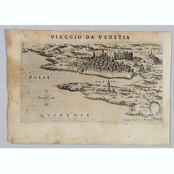
Polla Querrner [Pula in southern Istria)
Very rare view of Pula in southern Istria, published in the first edition of "Viaggio da Venetia, a Costantinopoli. Per Mare, e per Terra, & infieme quello di Te...
Date: Venice, Giacomo Franco, 1598
![[View of Gulf of Trieste].](/uploads/cache/45191-250x250.jpg)
[View of Gulf of Trieste].
Very rare view of Gulf of Trieste published in the first edition of "Viaggio da Venetia, a Costantinopoli. Per Mare, e per Terra, & infieme quello di Terra Santa...
Date: Venice, Giacomo Franco, 1598
![[View of Caorle].](/uploads/cache/45190-250x250.jpg)
[View of Caorle].
Very rare view of Caorle, at the time an island, published in the first edition of "Viaggio da Venetia, a Costantinopoli. Per Mare, e per Terra, & infieme quello...
Date: Venice, Giacomo Franco, 1598
![Larii Lacus Vulgo Comensis Descriptio . . . [and] Terretorii Romani Descrip. [and] Fori Iulii Vulgo Frivli Typus. . .](/uploads/cache/41008-250x250.jpg)
Larii Lacus Vulgo Comensis Descriptio . . . [and] Terretorii Romani Descrip. [and] Fori Iulii Vulgo Frivli Typus. . .
Set of 3 maps on one sheet of Lake Como, the region around Rome and the region around the Upper Adriatic, centered on Udinese from 'Theatrum Orbis Terrarum [Atlas of the ...
Date: Antwerp, 1598

Florentini Dominii Fidelissima et nova descriptio.
The map is centered on the city of Florence and extends to Liguria, the Apennine Mountains, the Adriatic Coast, Siena and Lago di Perugia. The map is based upon Stefano B...
Date: Anvers, 1598
![FIORENZA [FLORENCE].](/uploads/cache/49141-250x250.jpg)
FIORENZA [FLORENCE].
State 2 of this bird's-eye view of Florence. In the center, under the upper border, the engraved title "Fiorenza". At the top left, a compass rose is represente...
Date: Siena, Pietro Petrucci, ca. 1600
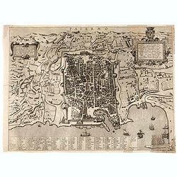
Palermo.
Rare bird's-eye view of Palermo, the plan showing the city and harbor within the city walls, with the surrounding countryside, title and dedicatory verse set in elaborate...
Date: Seina, ca. 1600
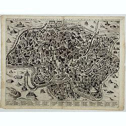
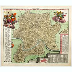
Antiquae urbis perfecta et Nova delineatio. [ Ancient Rome)
First state before imprint of Jacobus de Rubeis. A rare view of Ancient Rome from the Lafreri-School in the style of Ambrogio Brambilla's view of about 1575. A unique opp...
Date: Rome, ca. 1600
![Ornithon sive Aviarum M. Varronis Pyrro.Ligorio.Neap.inv. [The reconstruction by Pirro Ligorio of the aviary of Marcus Varro].](/uploads/cache/49261-250x250.jpg)
Ornithon sive Aviarum M. Varronis Pyrro.Ligorio.Neap.inv. [The reconstruction by Pirro Ligorio of the aviary of Marcus Varro].
The print, depicting the reconstruction by Pirro Ligorio of the aviary of Marcus Varro in Rome, was printed by Giovanni Orlandi in 1602 from a copperplate originally eng...
Date: Rome, 1581-1602

Capitolii sciographia ex ipso exemplari Michaelis Angeli Bonaroti a Stephano Duperac Parisiensi accurate delineata…
View of the Roman Capitol as re-designed by Michelangelo, from "Speculum Romanae Magnificentiae", first published in 1569, this example edited by Giovanni Orlan...
Date: Rome, Orlandi, 1602

Il vero ritratto di Nettvno al presente oaupato da gl'imperiali.
Rare and early town-plan of Nettuno, in the province of Rome, which is nowadays a touristic harbor.Issued by Joannes Orlandi who acquired many Lafreri plates, which he re...
Date: Rome, 1557 / 1602

La marca d'Ancona. Marchia Anconitana Picaenum olim dicta. . . Romae apud Joannem Orlandini formis Rome 1604.
A re-issue of the plate by Vicentium Luchinù of 1564 now with the address of Orlandini and the dates 1602 / 1604.A unique opportunity to acquire a fine example of a map f...
Date: Rome, 1604
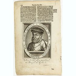
Ionnes III. D. G. Portugaliae Algarbiae etc. Rex. Decimus- Quintus / Fredeicus. II. Exul, Rex Neapolitanus XXI.
The engraving depicts a half length oval portrait of Naples King Fredericus. II and Portuguese King Iohannes III..Nicolaes de Clerck (de Klerc) was active as engraver and...
- $45 / ≈ €39
Date: Amsterdam, Cloppenburch, 1621

Fredeicus II. EXVL, Rex eapoltanus XXI.
The engraving depicts a half length oval portrait of "Fredericus II" and on the verso a portrait of "Ferdinandus V".Nicolaes de Clerck (de Klerc) was ...
- $20 / ≈ €17
Date: Amsterdam, Cloppenburch, 1621
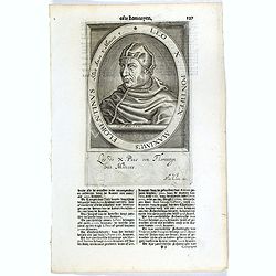
Leo X. Pontifex Maximus Florentinus Sedit Annos 8 Menses 8. / Paulus Quartus Neapolitanus Pontifex Maximus..
The engraving depicts a half length oval portrait of the Pope "Leo X", signed lower right corner N. de Cleck".On verso a half length oval portrait of "...
- $15 / ≈ €13
Date: Amsterdam, Cloppenburch, 1621
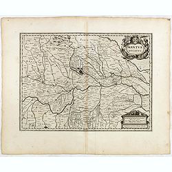
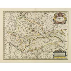
Mantua ducatus.
Originally engraved for Jodocus Hondius II, at his death in August 1629 this map was, among 39 other copper plates, purchased by Willem Blaeu who deleted Hondius' name an...
Date: Amsterdam, 1634
Mantua ducatus.
Important map of northern Italy centered on the dramatic fortress of Mantua.
Date: Amsterdam, 1635
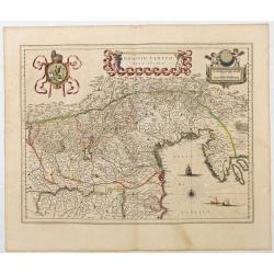
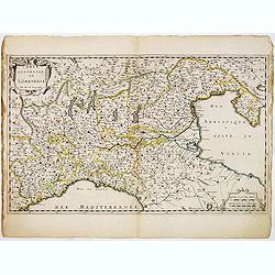
Dominio Veneto nell' Italia.
Blaeu's map of the Dominion of Venice. This influential map is adorned by a cartouche of the city of Venice, a winged Lion, a title cartouche of putti and an entwined rib...
Date: Amsterdam, 1635-1638

Dominio Veneto nell' Italia.
With the Gulf of Venice. Including the towns of Cremona, Brescia, Venice, etc.As Willem Blaeu died in 1638 most of his maps are actually published by his son Joan. This m...
Date: Amsterdam, 1638
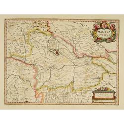
Mantua ducatus.
Centered at the town of Mantua.As Willem Blaeu died in 1638 most of his maps are actually published by his son Joan. This map carries his (engraved) signature and was act...
Date: Amsterdam, 1638
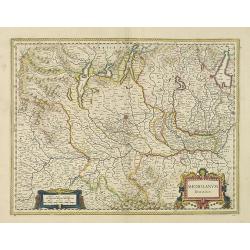
Mediolanum Ducatus.
Very fine map centered on Milan Including Lake Como, Lake Garda, Lake Majore, Parma, etc.As Willem Blaeu died in 1638 most of his maps are actually published by his son J...
Date: Amsterdam, 1638
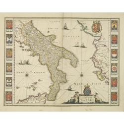
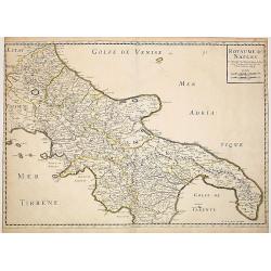
Regno di Napoli.
To the left and right 12 coats of arms of different regions.As Willem Blaeu died in 1638 most of his maps are actually published by his son Joan. This map was actually pu...
Date: Amsterdam, 1638
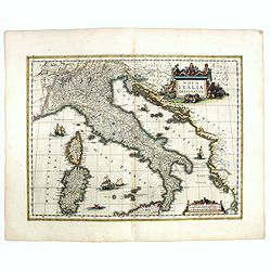
Nova Italiae delineatio.
Originally engraved for Jodocus Hondius II, at his death in August 1629 this map was, among other copper plates,purchased by Willem Blaeu who trimmed the figured borders,...
Date: Amsterdam, 1638
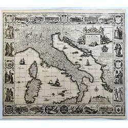
Tabulae Italiae, Corsicae, Sardiniae, et adjacentium..
A decorative map by this famous Dutch mapmaker. The border contains views of the main cities, largely inspired by the Civitates Orbis Terrarum by Braun & Hogenberg: R...
Date: Amsterdam, 1628,1640
Serenissimae Reipublicae Genuensis Ducatus et Dominii.
Includes the coast of the Riviera from Nice to La Spezia. A most decorative and rare map because it was only included in the Vrients' editions of the Ortelius Theatrum . ...
Date: Antwerp, 1609-1641
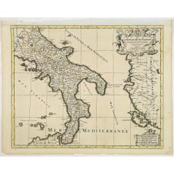
Royaume de Naples..
Fine map of the southern part of Italy.This edition carries the date 1648, engraved by AB. De la plaets. With the manuscript number in the upper right corner.Nicolas Sans...
Date: Paris, 1648
![[ The repositioning of the Vatican obelisk ]](/uploads/cache/49045-250x250.jpg)
[ The repositioning of the Vatican obelisk ]
Joan Blaeu published The Repositioning of the Vatican Obelisk. This large engraving on multiple sheets and in beautiful original colors is based on Domenico Fontana’s dra...
Date: Amsterdam, 1649

Chorographica descriptio provinciarum, et conventum fratrum minorum S. Francisci Capucinorum...
All maps are good and dark impressions. Several maps with slight foxing and browning, the folding map with 2 splits (top right part 10 cm and lower left part 6 cm into en...
Date: Turin, 1649
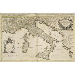
Carte Générale de Lombardie.
Fine map of Northern and middle part of Italy, engraved by A Peyrouin. According to the credit in the cartouche the map has been prepared by Pierre Duval.
Date: Paris, ca. 1650
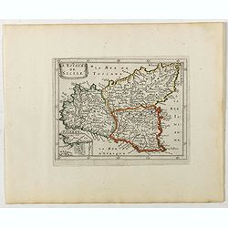
Le Royaume de Sicile.
Uncommon map Sicily and part of Palermo. Very good impression.Like Sanson, Briet was born in Abbeville and became a Jesuit at age 18. His "Parallela Geographiae Vete...
Date: Paris, 1653

Neapolis.
A rare panoramic of Naples with over the whole length of the lower part 3 columns of poems in Latin, Dutch and French.Published by Dancker Danckerts (1634-1666).
Date: Amsterdam, 1660
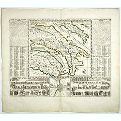
Estat De La Seigneurie De Venize en Italie.
Map of The Venetian Dominion inspired by the map of Jodocus Hondius. Published "A Paris Chez Pierre Marietti (sic), Rue Sainct Jacques A l'esperance". Decorated...
Date: Paris, ca. 1670
![Nova & exacta Chorographia Latii sive Territorii Romani iuxta veterem et novum situm parallela nomimu[m] comparatione elaborata.](/uploads/cache/44863-250x250.jpg)
Nova & exacta Chorographia Latii sive Territorii Romani iuxta veterem et novum situm parallela nomimu[m] comparatione elaborata.
Map of central Italy, centered on Rome from "Latium" by A. Kircher and designed by Innocenzo Mattei. The title cartouche in the lower right, small legend with 1...
Date: Amsterdam, 1671
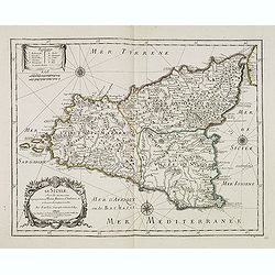
La Sicile, avec les anciens noms de presque toutes ses Places, Rivières, Chateaux &c. et diverses observations nouvelles . . .
Uncommon map of Sicily with fine title cartouche lower right . Original date of 1675 now altered to 1676.More about [+]
Date: Paris, 1676

Histoire de la République de Venise.
The History of the Republic of Venice Historia della Republica Veneta (dal 1613 al 1671), in Italian, which goes from 1613 to 1671, was translated by François Tallemant, ...
- $1800 / ≈ €1574
Date: Cologne, Pierre Marteau, 1682
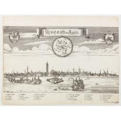
Venedig in Italien.
View of Venice with a numbered key 1-24. Lower right below the legend " Iohan Philip Steüdner ex Augusta". From "Theatrum Adriaticum, oder Schau-Platz deß ...
Date: Augsburg, 1685
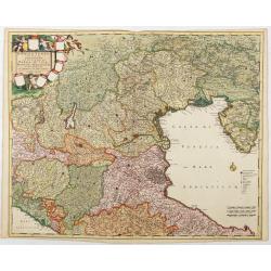
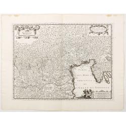
Accuratissima Dominii Veneti in Italia..
Detailed and decorative map centered on Venice, Vicenze, Mantova, Parma and Bologna, extending from Stato di Milano and Genoa to Istria. Decorative title cartouche in upp...
Date: Amsterdam, c. 1690
Accuratissima Dominii Veneti in Italia..
Detailed and decorative map centered on Venice, Vicenze, Mantova, Parma and Bologna, extending from Stato di Milano and Genoa to Istria. Decorative title cartouche in upp...
Date: Amsterdam, c. 1690

Les vallées du Piemont. Habitees par les Vaudois ou Berbets. . .
Detailed map of Piedmont region covering French and Italian territories. Surrounded by a French text description "Description des vallées du Piemont qu'habitent par ...
Date: Paris, 1690
Le royaume de Naples divise en 12 provinces.
Fine map of Royaume of Naples with a decorative title and scale cartouche.Alexis-Hubert Jaillot (1632-1712), was a French cartographer. He joined the Sanson heirs and red...
Date: Amsterdam, 1692
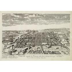
Turin ville capitale du Piémont, et Résidence du Duc de Savoye. . .
A very decorative and rareof Turin, including a numbered key (A-M) in lower part. Engraved by Pierre-Alexandre Aveline. With "fait par Aveline avec privilege du Roy ...
Date: Paris, ca.1692
L'Italie distinguee suivant l'estendue de tous les estats. . .
Fine map of Italy with a decorative title and scale cartouche.Alexis-Hubert Jaillot (1632-1712), was a French cartographer. He joined the Sanson heirs and redrew Nicolas ...
Date: Amsterdam, 1692

La Basilica Vaticana consacrata al Principe de gli Apostoli . . .
Monumental engraving showing the Papal Basilica of St. Peter in the Vatican, in its setting, with below a coat of arms with dedication to Cardinal Sigismondo Chigi. Obili...
Date: Rome, 1693

Piazza e tempio di Santa Maria della Rotonda gia l'Antico Pantheon.
Monumental engraving showing the Pantheon in Rome, in its setting, with below a ground-plan and elevation. Fountain in front, adjacent buildings and carriages and people ...
Date: Rome, 1693
Principaute de Piemont Seigneurie de Verceil... Principauté d'Oneglia... Le Comté de Nice le Marquisat de Salusse et Principauté de Monaco.
This spectacular engraved map of the Comté de Nice et Principauté de Monaco features striking coloring and lettering heightened in gold.The style is similar to that of th...
Date: Paris, 1693

Naples. 1699. Nouvelle et exacte description de la tres-celebre & ancienne Ville de NAPLES
Only recorded large-scale broad sheet panoramic view of Naples with underneath in letterpress a description of the town's history : "Nouvelle et exacte description d...
Date: Paris, 1699
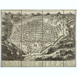
Plaisance ou Piacensa, ville de la Lombardie, capitale du duché de Plaisance.
Rare and beautiful bird's-eye plan of the town of Plaisance in Lombardy, accompanied by 120 key to the most important points in town. Second state with " XIX" i...
- $400 / ≈ €350
Date: Amsterdam, 1704

La Place de Saint Marc a Venise.
A very attractive Town plan of the place St Marc in Venice.Joan Blaeu published during his life three town books of Italy: Citta del Vaticano, Rome, and Napoli. By the ye...
Date: Amsterdam, 1705
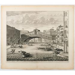
Veue du Pont de Rialto de Venise.
Spectaculair view of Rialto bridge in Venice. Joan Blaeu published during his life three town-books of Italy: Citta del Vaticano, Roma and Napoli. By the year 1672 a fire...
Date: Amsterdam, 1705
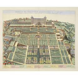
Hortus et Palatium Atestinorum Tyburi.
Showing in great detail the hortus and gardens of Villa Tivoli.Joan Blaeu published during his life three town-books of Italy: Citta del Vaticano, Roma and Napoli. By the...
Date: Amsterdam, 1705
Carte de Geographie des Differents Etats de la Republique de Venise. . .
An attractive and detailed engraving of the Gulf of Venice and adjacent Italian and Dalmatian coastlines. The main map runs diagonally across the sheet with inset detail ...
Date: Amsterdam, 1710
Diocesi Padovana Con Tutta La Sua Estensione Ne Vicini Territori.
This large map depicts the entire extent of the Diocese of Padua and the surrounding territories, with a detailed topographical rendering. It features rich Baroque ornam...
Date: Padova, 1720
Urbis Romae Veteris ac Modernae Accurata Delineatio. . .
A wonderful 'bird's eye' view of the 'Eternal City' of Rome by Homann, although published in the first quarter of the eighteen century, the map portrays the city at the e...
Date: Nuremberg, ca 1720

Nostre Dame de Lorette.
A very RARE panoramic of Lorette and the church, including a numbered legend in both lower corners.The plate is numbered in black pencil in upper right corner.Published ...
Date: Paris c.1720
L'Italie dans son Premier Etablissement sous la Republique Romaine. . .
Map of Italy when first established under the Roman Republic after the division by Ayuguste Caesar, its various Papal governments: ancient Rome and its surround dings, a ...
Date: Amsterdam, 1728
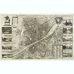
Florentia Pulcherrima et Ruriae Civitas.
Detailed bird's-eye view of the town of Florence in Tuscany region, first published in Frederick de Wit's rare town book. With two keys 1-17 and 1-228 to important spots ...
Date: Amsterdam, Leiden, 1697 / 1729
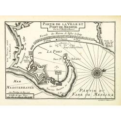
Plan de la Ville et Port de Messine.
An attractive chart centered Messina on Sicily. With scale and large compass-rose. Dated 1727, with the privilege of the King. From : Recueil des Plusieurs plans des port...
Date: Marseille, 1730
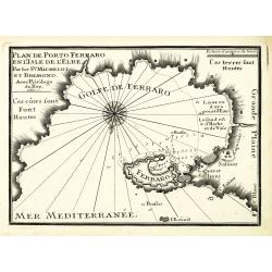
Plan de Porto Ferraro en l'isle de l'Elbe.
An attractive chart centered on the Mediterranean. With scale and large compass-rose. Dated 1727, with the privilege of the King. From : Recueil des Plusieurs plans des p...
- $200 / ≈ €175
Date: Marseille, 1730
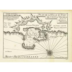
Plan de la Ville et Port de Civita-Vechia.
An attractive chart centered on Civitavecchia, a town and comune of the province of Rome in the central Italian region of Lazio.With scale and large compass-rose. Dated 1...
- $200 / ≈ €175
Date: Marseille, 1730
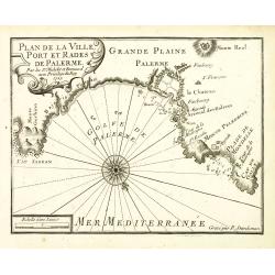
Plan de la Ville, Port et rades de Palerme. . .
An attractive chart centered on Palermo. With scale and large compass-rose. Dated 1727, with the privilege of the King. From : Recueil des Plusieurs plans des ports et ra...
Date: Marseille, 1730
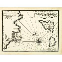
Plan du Port de Trapano et des isles Favouillane.
An attractive chart centered on Trapani on the west coast of Sicily in Italy. It is the capital of the Province of Trapani. The right the island of Favignana and Levanzo ...
Date: Marseille, 1730
