Browse Listings
![[Printed on silk] Nova Totius Americae Sive Novi Orbis Tabula, Auct. Hugo Allardt.](/uploads/cache/48420-250x250.jpg)
[Printed on silk] Nova Totius Americae Sive Novi Orbis Tabula, Auct. Hugo Allardt.
Hugo Allard’s ca. 1661 map of the Americas, showing California as an island printed on silk. This separately issued map printed on paper is quite rare on the market. T...
Place & Date: Amsterdam, 1661

Voyage de découvertes aux Terres Australes. Historique. Atlas Deuxième partie.
First edition of the second part of the atlas by Freycinet, part of his important book "Voyage de découvertes aux Terres Australes". Illustrated with two foldi...
- $7500 / ≈ €7018
Place & Date: Paris, Langlois, 1811

Nova Helvetiae Tabula.
A most decorative "carte à figures" map with panoramic views of Lucern, S.Gal, Bern, Solothurn, Schafhausen in upper border and Basel and Zurich in lower left ...
Place & Date: Amsterdam, 1630

A plan of the City and Environs of Philadelphia. . .
The Lotter edition of Scull & Heap's seminal Philadelphia map, which map was first issued in 1752.Holmes' grid plan for the city is shown, situated between the rivers...
Place & Date: Augsburg, 1777

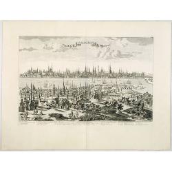
Paris.
A spectacular panoramic view of Paris, with legends numbered from 1-70 in French. With the title in a banderol.After a design by Friedrich Bernhard Werner (1690-1776) who...
Place & Date: Augsbourg, ca. 1740

A fan combines views of Hong Kong (right), Canton (left), China, ca 1850-1860.
The fan shows nice images of Hong Kong and Canton on onside and on verso a garden with 39 characters welcoming a rider on his white horse. Their clothes are heightened in...
Place & Date: China, ca. 1850-1860
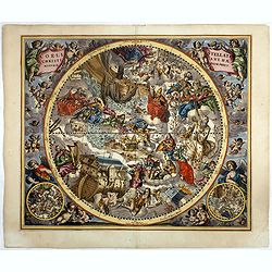
Coeli Stellati Christiani Haemisphaerium Prius.
Scarce first issue. This spectacular celestial chart presents the constellations according to Christian symbolism. The view of the constellations is based on the work of ...
Place & Date: Amsterdam, 1660
![Ch'onha chido. [Atlas of all under Heaven]](/uploads/cache/44640-250x250.jpg)
Ch'onha chido. [Atlas of all under Heaven]
A late 18th century Ch'onha chido atlas with 10 woodblock maps showing the World, China and the 8 province maps of Korea, bound into thicker mulberry paper covers. One ma...
Place & Date: Korea, ca. 1780

Il regno della China detto presentente Catay e Magnin. . .
A rare and decorative Italian map of China and Japan, with Japan closely modelled on the indented Cardim outline and Hokkaido, called Yuppi , shown as an Asian peninsula....
Place & Date: Rome, 1682

Pascaerte vande Caribische Eylanden, vande Barbados tot aende Bocht van Mexico ‘t Amsterdam By Hendrick Doncker. . .
First state. Rare. “This chart appeared in the first edition of Hendrick Doncker’s Zee-Atlas, of which no surviving example is known” -- Burden. This is an example ...
Place & Date: Amsterdam, 1659

Nieuwe en zeer accuraate Zee-Caart van de Hollandse Wal strekkende van de Maas tot Texel opgenomen door Jan Rokusz Douw, , ,
A very fine and rare chart of the coast of Holland, Prepared by Jan Rokusz, Douw and Agge Roskam Kool.Embellished with a very decorative cartouche with a dedicational tex...
Place & Date: Amsterdam, 1750

Nouvelle Mappa Monde.
State 2 of this fine double hemisphere world map, from an unusual perspective, with a "Mer de L'Ouest" or "Sea of the West". Paris is located at the c...
Place & Date: Venice, 1776 - 1784

L'Africa divisa nelle sue Parti secondo le pui moderne . . .
A beautiful and rare two-sheet map of Africa. The title cartouche is depicted on a drape surrounded by native animals.A most noticeable feature of the decoration on the m...
Place & Date: Venice, 1690

Transom of a ship in gilded carved wood bearing the inscription "DUMONT- DURVILLE"
Decorative transom sign in gilded carved wood bearing the inscription "DUMONT- DURVILLE" in a foliage environment. The transom usually kept the name of the ship...
Place & Date: France, ca. 1880
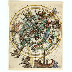
(Northern celestial planisphere with a pasted volvelle.)
Probably by the Vienna astronomer Melchior Klayber who used the Copernican precession theory, which is closely connected with the chart (Ptolemy - 6° 40' and Ptolemy - 5...
Place & Date: Vienna, ca. 1569

Calendrier de la cour, tiré des éphémérides, pour l'Année bissextile.. / Notebook bearing silver plates with the VOC monogram.
A personal gift, only made for the trustees of the V.O.C. The silver plate was probably made by Drick van Hengel and Company because an entry in the diary of mintmaster J...
Place & Date: Paris, 1787

Carte des côtes du Golfe du Mexique compris entre la pointe sud de la presqu'Ile de la Floride et la pointe nord de la presqu'Ile d'Yucatan: Dresée d'après le observations et las plans des espagnols, ...
Detailed and important early chart of the Gulf Coast and Florida and dated 1800. First French edition of "the first printed [map] to show and name Galveston Bay&qu...
Place & Date: Paris, 1800

Frisia occidentalis.
A rare separately published carte-a-figures of Friesland by Geelkercken in its first state. The title and the coats of arms of the eleven Frisian towns appear in the cent...
Place & Date: [Leeuwarden], Dierick Albertsen, 1618

La Place de Saint Marc a Venise.
A very attractive Town plan of the place St Marc in Venice.Joan Blaeu published during his life three town-books of Italy: Citta del Vaticano, Rome and Napoli. By the yea...
Place & Date: Amsterdam, 1705

Pas-Kaat vaneen gedeelte van de Aethiopische Zee behelsende de Kusten Zanguebar, Ajan en Abex, en een gedeelte van de Arabische Kust. . .
A finely engraved and detailed chart of the most eastern tip of Africa, including Somalia, Djibouti, Yemen, Mauritius, and many other islands in the Indian Ocean.Very rar...
Place & Date: Amsterdam, 1753

Nouveau Plan Routier de la Ville et Faubourgs de Paris // Avec ses principaux Edifices et Nouvelles Barrieres.
Decorative wall map of Paris, published by M. P|chon in Paris and engraved by Michel Glot. The plan is framed by a floral border and there are 27 Parisian views of places...
Place & Date: Paris, 1834

Tabula Prima Africa.
The map apart from depicting Morocco also shows southern Spain and the Balearic Islands. In north Africa the map extends eastwards toward modern day Algeria and to the we...
Place & Date: Strasbourg, 1513

Les Villes forts et châteaux de Malte capitale de l'isle de ce nom. Dessignée sur le lieu par un Ingr du roy.
A very decorative and extremely rare town-view of Valetta, including a numbered legend in lower part. Published by Jacques Chereau, (1688 - 1776). Engraved by Aveline and...
Place & Date: Paris, ca.1750
![[Crimea]. Carte de la Cromée.](/uploads/cache/25719-250x250.jpg)
[Crimea]. Carte de la Cromée.
Mapmaker, Captain Jan Hendrik van Kinsbergen (1735-1819). Published by H. Friesman in 1787. This map first appeared in 1776 and was the first Russian map of the newly ann...
Place & Date: Amsterdam, H. Frieseman, 1787

Paris, Lutetia, Parisii, Ville Capitale du Royaume de France.
View of Paris seen from the hill "Belleville based on that of Merian (1616) but updated with the new gates Saint-Denis and Saint-Martin. With a key 1-78 and A-Z. Sur...
Place & Date: Paris, after 1676
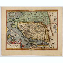
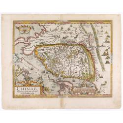
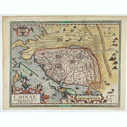
Chinae, olim Sinarum Regionis, nova descriptio. Auctore Ludovico Georgio.
The first map of China ever to appear in a Western atlas, west to the top. The second state with "Las Philipinas" somewhere in 1587 added to the plate. When thi...
- $6000 / ≈ €5614
Place & Date: Antwerp, 1592
![Amerique Septentrionale divisée en ses principales parties. . .1685. [California as an Island]](/uploads/cache/60628-250x250.jpg)
Amerique Septentrionale divisée en ses principales parties. . .1685. [California as an Island]
Engraved by Cordier. Spectacular example of Jaillot's map of North America, showing California as an Island, based upon Sanson's landmark map of 1656. This map shows the ...
Place & Date: Paris, 1685

Comitatus Flandria.
First published by the van Langrens c.1595, after his acquisition of the plate, Visscher heavily re-engraved the map, inserting panelled borders on three sides (the lower...
Place & Date: Amsterdam, c. 1630

Carte d'Asie divisée en ses principaux Etats.
Uncommon and decorative "carte à figures" wall map, prepared by Clouet, with superb decoration including a wonderful rococo border with vignettes describing hi...
Place & Date: Paris, Mondhare, 1787
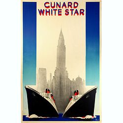
Cunard White (Queen Mary et Queen Elizabeth de la Cunard Line).
Rare original vintage travel advertising poster for Cunard White Star, the fastest Ocean Service in the World. Stunning Art Deco style illustration of the two majestic fl...
Place & Date: Paris, 1938

(Sea-chart of Catalunia, Languedoc, Provence, Cote d'Azur, Riviera, Corsica with Marseille, Cannes, Nice, Monaco.)
This very rare chart is important as the first printed sea chart of France's Mediterranean coast, also depicting Catalunya's northern coast, the Italian Cote d'Azur till ...
Place & Date: Amsterdam, 1607

Lutetia Furens. Das ist : Die wütende Statt PARIS.
Rarissime placard dirigé contre la Ligue et le duc de Mayenne. La gravure est signée I.S. (marque inconnue). Ce placard en latin et en allemand est une reprise de l’e...
Place & Date: France ca.. 1594
Grand atlas universel ou collection de cartes encyprotypes, générales et détaillées des cinq parties du monde.
Large folio atlas containing 8 general one-sheet maps, and 8 detailed four-sheet maps: Containing2 World maps- "Mappe-monde sur la projection de Mercator. Carte ency...
- $6000 / ≈ €5614
Place & Date: Paris, Desray, 1816

Atlas des Missions de la Société des Missions-Étrangères. . .
This scarce atlas contains maps showing the locations of the Catholic missions belonging to the Société des Missions Étrangères in Asia. It covers India, Burma, Siam,...
Place & Date: Lille, 1890
![Le Isole di Sandwich delineate sulle osservazioni del Cap Cook. [Hawaii]](/uploads/cache/43195-250x250.jpg)
Le Isole di Sandwich delineate sulle osservazioni del Cap Cook. [Hawaii]
FIRST EDITION on laid paper. Cassini’s splendid map depicts Sandwich islands, old name for Hawaii islands, at the end of the eighteenth century. The splendid cartouche ...
Place & Date: Rome, 1798
![[Set of 6 maps] Charta öfver Storfurstendömet Finland på Friherre S. G. Hermelins Anstalt och Omkostnad. Sammandragen och författad af C. P. Hällström. Philos. Magister och Auscultant i Kongl. BergsColl. 1799.](/uploads/cache/34482-250x250.jpg)
[Set of 6 maps] Charta öfver Storfurstendömet Finland på Friherre S. G. Hermelins Anstalt och Omkostnad. Sammandragen och författad af C. P. Hällström. Philos. Magister och Auscultant i Kongl. BergsColl. 1799.
This is the beautiful set of key map and separate maps of Samuel Gustav Hermelins map of Finland. The maps have been engraved by Fredrik Akrel, a very skilled and product...
Place & Date: Källa: J.Strang & E.- S. Harju: Suomen karttakirja 1799

Hydrograhica descriptio
This very rare chart is important as the first printed sea chart of the Mediterranean coast of Spain, Gibraltar, also depicting the northern coast of Marocco.Willem Bar...
Place & Date: Amsterdam, W.Blaeu, 1612
Introduction à la géographie en plusieurs cartes avec leur explication. Par les Srs Sanson Géographes Ordinaires du Roy. Dédiée à Monseigneur Jean Paul Bignon.
An extremely rare scientific atlas, published in 1707, followed by 29 maps published and oft corrected by P. Moullart-Sanson, with 18 maps relating to the Americas.First ...
- $7500 / ≈ €7018
Place & Date: Paris, Dans le Cloître de St Nicolas du Louvre, 1707

A Newe mape of Poland Done into English by I.Speede.
A wonderful map of Poland. Incorporated into Speed's 'Prospect Of The Most Famous Parts Of The World.' Includes birds-eye views of Cracow, Dantzick, Posna, Crossen, Sando...
Place & Date: London, 1627

Tabula Secunda Europe (Spain & Portugal)
Wood block printed large-format Ptolemaic map of the Iberian Peninsula from the 1513 edition of Waldseemüller's Geographia.This Ptolemaic map comes from the first so cal...
Place & Date: Strasburg, 1513

Terra Promissions.
A beautifully executed and very rare map of the Promised Land, divided into the 12 Tribes. The shore line runs in north-southwesterly direction from Sidon as far as Pelus...
Place & Date: Paris, c.1655

Germania.
Second state of this rare "carte à figures"- map of Germany, The Netherlands, Poland and central Europe. Bordered on three sides with portraits and views. In t...
Place & Date: Amsterdam, 1607

I Europa / Das dritteil der Welt.
Very early wood cut printed map of Europe with South to the top. In the lower-left corner we see Poland, Livonia and parts of England and Ireland in the lower right corne...
Place & Date: Zurich, Christoffel Froschover, 1548,1552-1566
Der curiose und ... Nüssliche Dollmetscher..
Rare atlas and containing geographical descriptions of all continents. Illustrated with 30 very finely engraved and beautifully colored maps in attractive original strong...
- $6000 / ≈ €5614
Place & Date: Augsburg, 1748

Carolinae Floridae nec non Insularum Bahamensium cum partibus adjacentibus delinatio ad Exemplar Londinense in lucem edita . . . Ao. 1755.
The German edition of this map of Carolina, Florida, and the Bahama Islands in full original colors. Published in Seligmann's "Sammlung verschiedener auslaendischer ...
Place & Date: Nuremberg, 1755

Tabula nova Poloniae et Silesiae.
Second state, dated 1630 underneath the title. A finely engraved carte á figures with cartouche representing in the four corners of the map : Kings ( on the left side Si...
Place & Date: Amsterdam, 1630

Nieuwe en Nette Afteekening van het Eyland Corsica en het Eyland Elba vertoonende alle desselfs Havenen, Steeden en Rivieren . . .
Highly decorative large sea chart of Corsica, Sardinia and Elba, including multiple sailing ships, compass roses, cartouche, coat of arms, rhumb lines, topographical deta...
Place & Date: Amsterdam, ca. 1710
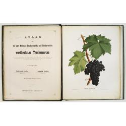
Atlas der für den Weinbau Deutschlands und Oesterreichs werthvollsten Traubensorten. Mit genauer Beschreibung der Eigenschaften, Cultur-Methoden und des Schnittes...
Atlas der für den Weinbau Deutschlands und Oesterreichs werthvollsten Traubensorten. Mit genauer Beschreibung der Eigenschaften, Cultur-Methoden und des Schnittes, der A...
Place & Date: Vienne, Wien, Faesy und Frick, 1873-1876

Tabula nova utriusque Indiae.
This is the fourth and last edition of this map based on Waldseemüller's first "modern" map of Asia. It follows that cartography without change but adds an int...
Place & Date: Vienne, 1541

La marca d'Ancona. Marchia Anconitana Picaenum olim dicta. . . Romae apud Joannem Orlandini formis Rome 1604.
A re-issue of the plate by Vicentium Luchinù of 1564 now with the address of Orlandini and the dates 1602 / 1604.Collector's item. A unique opportunity to acquire a fine...
Place & Date: Rome, 1604

Americae Nova Tabula.
An inset shows Greenland and Iceland. Decorative elements include ships, sea monsters, and vignettes of native Americans within South America. In addition, the map is bor...
- $7500 / ≈ €7018
Place & Date: Amsterdam, 1644
Constantinople ville de Romanie et capitale de l'Empire des Turcs.
A very decorative and extremely rare of Istanbul, including a numbered legend in lower part. Published by Jacques Chéreau, (1688 - 1776). Engraved by Aveline and first ...
Place & Date: Paris, ca.1750
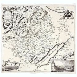
Incliti Cantonis Friburgensis Tabula, autore Francisco Petro VON DER WEID. Senatore et Commissario generale Friburgi. anno Domini 1668.
Very rare 2-sheet map and the first map of the canton Fribourg (Freiburg) in a scale of Scale 1:120.000. South to the top.The area shown on the map encompasses the whole ...
- $7500 / ≈ €7018
Place & Date: Fribourg, 1668

Gallia.
Extremely rare map of France, Netherlands, Southern England, Switzerland, and Northern Spain. This map was never regularly included in the Theatrum; Denuce mentions the i...
Place & Date: Antwerp, ca 1598

A Map of the Environs of Constantinople Drawn from a great number of accurate astronomical & geographical manuscripts and printed documents, by A. Arrowsmith 1801 and 1804.
Arrowsmith’s large and detailed map of the Ottoman Empire and the Black Sea, with Cyprus, Crete and the Greek Islands in the Mediterranean Sea, Albania, Bosnia and Herz...
Place & Date: London, No.10 Soho Square, 4th September 1804

Asia secunda pars terrae in forma Pegasi.
Asia depicted as the flying horse Pegasus. Thiscartographical curiosity, double page copper engraved map, was published in Heinrich Bünting's “Itinerarium Sacrae Scrip...
Place & Date: Brunswick, 1640
![[Title page colored by Georg Mack Jr. to : Hortus Eystettensis, Sive Diligens et Accurata Omnium Plantarum, Florum, Stirpium,. . .]](/uploads/cache/39343-250x250.jpg)
[Title page colored by Georg Mack Jr. to : Hortus Eystettensis, Sive Diligens et Accurata Omnium Plantarum, Florum, Stirpium,. . .]
Title page to the first edition, one of about 300 copies printed, from one of the largest and most magnificent of the great flower books, depicting more than 1000 flowers...
Place & Date: Nuremberg, ca 1613

Angliae, Scotiae, et Hiberniae, sive Britannicar : Insularum descriptio.
A rare and ornate map with inset portraits of James First, Henry Prince of Wales Princess Anne of Denmark.Janssonius acquired the copperplate of van den Keere's 1604 Brit...
Place & Date: Amsterdam, 1621

A Map of the most Inhabited part of New England containing the Provinces of Massachusetts Bay and New Hampshire, with the Colonies of Connecticut and Rhode Island.
A copper engraving in four sheets, published in Georges Louis Le Rouge, in his "Atlas Ameriqua in Septentrional Contenant les details des differentes provinces, de c...
Place & Date: Paris, 1777
![Carte de la coste orientale de la Chine depuis Amoy, jusqu'à Chusan avec une partie de l'Isle Formose [with] Plan du port d'Amoy ou Emouy.](/uploads/cache/33583-250x250.jpg)
Carte de la coste orientale de la Chine depuis Amoy, jusqu'à Chusan avec une partie de l'Isle Formose [with] Plan du port d'Amoy ou Emouy.
Important French chart of the China Sea with the coast of Northern China, including a large depiction of Formosa.Latitude and longitude scales, compass rose and system of...
Place & Date: Paris, Jean-François Robustel, 1745

Ambassades mémorables de la Compagnie des Indes orientales des Provinces Unies vers les empereurs du Japon.
First edition in French of this important work on Japan, a work whose illustrations "represent a high-water mark in book illustrations of the 17th century" (Lac...
- $5500 / ≈ €5146
Place & Date: Amsterdam, 1680
Het Groote Tafereel der Dwaasheid, vertoonende de opkomst, voortgang en ondergang der Actie, Bubbel en Windnegotie, in Vrankryk, Engeland, en de Nederlanden, ...
FIRST ISSUE of this biting and vulgar satire on the Mississippi and South Sea Bubbles and an extraordinary visual record with 78 plates of the first banking crash, show...
- $7500 / ≈ €7018
Place & Date: Amsterdam, 1720

Naaukeurige Platte Grond van den Staat en den Loop van Rio de Berbice Met derzelver Plantagien in de Geoctrojeerde Colonie de Berbice Gelegen. . .
Uncommon large-scale map of Berbice with Rio de Berbice and Rio de Canjewith at the bottom left a list of plantation owners. In top 3 x 3 coats of arms in cartouches. The...
Place & Date: Amsterdam, 1742
Atlas Minor praecipua Orbis Terrarum Imperia, Regna et Provincias Germinae Potissimum, tabellis 50 exacte delineatis fiftens usui militiae ducum ac peregrinantium maxime accommodatus opera.
This collection of highly attractive maps were drawn by Georg Matheus Seutter and his son Albrecht Carl. Georg Matheus was one of the most important German Cartographers ...
- $5250 / ≈ €4913
Place & Date: Augsburg, 1744
![[12 volumes] Recueil des voyages qui ont servi à l'établissement et aux progrez de la Compagnie des Indes Orientales, forméedans les Provinces-Unies des Païs-Bas...](/uploads/cache/43700-250x250.jpg)
[12 volumes] Recueil des voyages qui ont servi à l'établissement et aux progrez de la Compagnie des Indes Orientales, forméedans les Provinces-Unies des Païs-Bas...
An important richly illustrated compendium of the first Dutch voyages to East India, of great interest for the history and establisment of the Dutch global trade, particu...
- $5000 / ≈ €4679
Place & Date: Rouen, Pierre Le Boucher, 1725

(The City And Harbour Of Sydney From Near Vaucluse.)
One of the most sought after views of the city and harbour of Sydney seen from Near Vaucluse, 1852. Magnificent hand-colored tinted lithograph and finished by gum-Arabic....
Place & Date: London, J. Hogarth, 1852

Pascarte van Europa Beginnende vande Canael tot aen Spitbergen, en van Ysland tot aen Nova Zemla . . .
An eye-catching chart of northern Europe with a coastline from northern Russia to the Dutch English Channel in the south. Good detail on Iceland. North to the top.In the ...
Place & Date: Amsterdam, after 1666
Chinae, olim Sinarum regionis. . .
The first printed map of China. It is signed by Ludovico Georgio, whose real name was Luis Jorge de Barbuda. He was a Portuguese Jesuit cartographer and besides that a sp...
- $6000 / ≈ €5614
Place & Date: Antwerp, 1608
![[Ritter Sundial Map of the World]](/uploads/cache/60731-250x250.jpg)
[Ritter Sundial Map of the World]
This highly unusual map projects the world from the north pole as though it were the table of a sundial, with the land masses drawn to scale in proportion to their distan...
- $4500 / ≈ €4211
Place & Date: Nuremberg, 1640
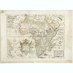
Africa ex magnae Orbis Terrae Descriptione.
Very rare separately published "Lafreri" map of Africa. The title in typical Italian scrollwork surmounted by two Cupids in the lower Atlantic. A dedication to ...
- $6000 / ≈ €5614
Place & Date: Venice, ca. 1590
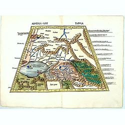
Septima Asie Tabvla.
Trapezoidal woodcut map showing the area around the Caspian Sea from Martin Waldseemüller's most important 1513 edition of Ptolemy, which was a landmark work that contri...
- $6000 / ≈ €5614
Place & Date: Strasburg, J. Schott, 1513
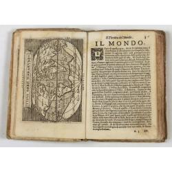
Theatro del Mondo di Abrahamo Ortelio..
Including maps of the world (Shirley, World 214): Europe; Asia; America (Burden, America 126, Marchetti 1598); Africa; England; Scotland; Ireland; Tercera; Spain (4); Por...
Place & Date: Venice, G. Turrini, 1655

SETTSU MEISHO ZUE. Illustrations of famous places in Settsu.
Settsu Meisho Zue was printed in two series of 8 and 4 volumes. The principal illustrator was Takehara Shunchosai, but many illustrations in the 4 volumes supplement are ...
Place & Date: Osaka, Yanagiwara Kibei, Kansei 8-10 or 1796-1798

Valletta ou Valete ville Forte, de l'Isle de Malta.
A beautifully engraved and richly detailed birds-eye plan of the harbour and city of Valletta seen from the northwest. In lower part extensive key, identifying 57 feautur...
Place & Date: Amsterdam, 1705

Shinkan Nagasaki no Dzu.
The oldest of these so-called Nagasaki pictures (Nagasaki-zu) were two panoramic prints by the artist Chikujuken that served as guides to the city of Nagasaki for visitor...
Place & Date: Nagasaki, 1801

Group of 21 watercolors of scenes in Iceland, included are vulcanos like Eyjafjallajokull, Öræfajökull, etc.
A group of water colors made during visits of the artist F. de Boungne to Iceland, among them are contemporary artistic impressions of the now world-famous volcano Eyjafj...
Place & Date: Iceland, 1933-1944

Europa recens descripta à Guilielmo Blaeuw.
On either side columns depicting the manner of dress in the major countries of Europe, surmounted by nine city views and plans.For European mapmakers their own continent ...
Place & Date: Amsterdam, 1644

Bern in der Schweitz.
Very fine panoramic of Bern. With a numbered key (1-25) of principal buildings in town.
Place & Date: Augsburg, 1740

Neapolis.
A rare panoramic of Naples with over the whole length of the lower part 3 columns of poems in Latin, Dutch and French.Published by Dancker Danckerts (1634-1666).
Place & Date: Amsterdam, 1660
Chinae, olim Sinarum regionis. . .
The first printed map of China. It is signed by Ludovico Georgio, whose real name was Luis Jorge de Barbuda. He was a Portuguese Jesuit cartographer and besides that a sp...
Place & Date: Antwerp, 1598