Browse Listings
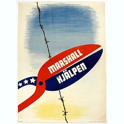
Marshall Hjälpen.
Marshall Plan poster made by Gusta Aberg, showing barbed wire cut by pliers with slogan on pliers: Marshall Hjälpen This is one of the 25 finalists in the 1950 “Intra-...
Place & Date: Kühn & Zoon Rotterdam, 1950
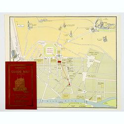
Souvenir Guide Map of Cairo.
A lovely small colored plan of central Cairo, published by Groppi in Cairo. Plan is housed within the original red and gold printed paper covers, with advertisements for ...
- $200 / ≈ €187
Place & Date: Cairo, 1920-1950
![[Planisphère] - Crédit Lyonnais - Fondé en 1863. Afrique du Nord à Union Française.](/uploads/cache/44865-250x250.jpg)
[Planisphère] - Crédit Lyonnais - Fondé en 1863. Afrique du Nord à Union Française.
Original pictorial lithographed advertising poster showing the western part of Africa. Published by the French bank Crédit Lyonnais.Design by Lucien_Boucher who is a fam...
Place & Date: Paris, 1950
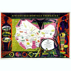
Afrique Occidentale Française AOF.
Beautiful and decorative lithograph pictorial map of Equatorial Africa, showing animals in a beautiful design… Made for Agence de la France d'Outre-Mer. The artist Alai...
- $1100 / ≈ €1029
Place & Date: Imprimerie Raidot, Paris, ca. 1950
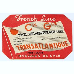
French Line First Class Bagages de Cale.
French Line First Class Bagages de Cale sticker for the journey Havre- Southhamptons New-York. It used to be stuck on luggage. The Compagnie Générale Transatlantique is...
Place & Date: Paris, ca. 1950

Beer poster.
Official Oktoberfest posters started being produced each year beginning in 1952. This poster was created by German artist Theodor Abeking. Other artists who made posters ...
- $300 / ≈ €281
Place & Date: Paris, ca. 1950
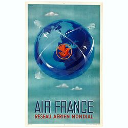
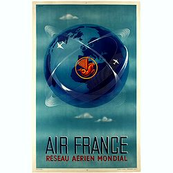
Réseau aérien mondial.
"Sur les ailes d'Air France, découvrez le monde à votre tour" lithograph poster from AIR France. A great mid-century design by Air France advertising poster b...
Place & Date: Imprimerie Perceval Paris, ca. 1940-1950
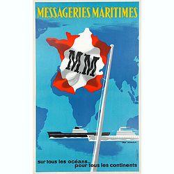
Messageries Maritimes, sur tous les océans, pour tous les continents.
Original lithographed poster from the 1950s by Jean Desaleux. The poster has a blue background and a map of the continents and oceans. France is in the colors of the Mari...
Place & Date: Paris, ca. 1950
AIR France - Réseau Aérien Mondial.
Original pictorial lithograph advertising planisphere poster from AIR France. The poster has a black background. In the lower right below the border '016/P/AF Printed in ...
Place & Date: Imprimerie Perceval, Paris, ca. 1950
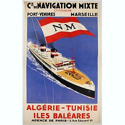
CIE. DE NAVIGATION MIXTE / ALGERIE - TUNISIE.
Advertising poster for Touache Cie, made by Sandy Hook and printed by Chaix, Paris. Sandy-Hook was a French painter, poster designer and illustrator specialized in repres...
- $900 / ≈ €842
Place & Date: Paris, ca. 1950
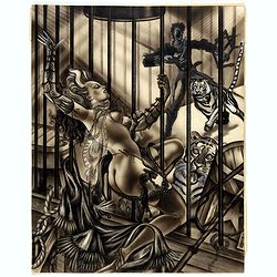
Tiger tamer.
Showing a tiger tamer with two tigers who apparently have more interest in his erotic, scarily dressed assistance.
Place & Date: ca. 1950
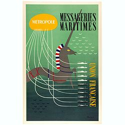
Metropole, Messageries Maritimes Union Française.
Original lithographed poster created by the artist Poulain for "Les Messageries Maritimes", showing several boats and a unicorn. Les Messageries Maritimes Compa...
Place & Date: Paris, ca. 1950
Réseau aérien mondial.
"Sur les ailes d'Air France, découvrez le monde à votre tour" advertising planisphere poster from AIR France, the French airline company. The poster has alway...
Place & Date: Imprimerie Perceval Paris, ca. 1940-1950
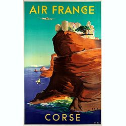
Air France - Corse.
Corsica poster for Air France, by Raoul Éric Castel (1915 - 1997) and published by Havas. Signed has work with Éric, he was born in Lyon and made many fine travel poste...
- $1200 / ≈ €1123
Place & Date: Imprimerie Perceval Paris, ca. 1940-1950
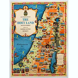
Ilustrated Map of The Holy Land for use in schools…
A visually striking and impressive pictorial map of The Holy Land, as issued by the National Savings Movement / Committee during the 1950s. In the upper left quadrant of...
- $250 / ≈ €234
Place & Date: London, ca. 1950
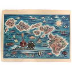
The Dole Map of the Hawaiian Islands.
A terrific, colorful poster of the Hawaiian Islands by Joseph Feher, commissioned for the Hawaiian Pineaple Co. The poster displays all eight of the major islands in the ...
- $250 / ≈ €234
Place & Date: USA, 1950
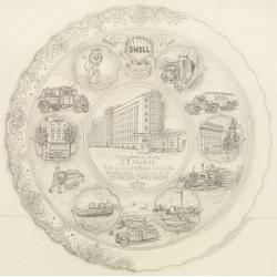
Shell : 9 Februari 1911-1951.
Decorative design-drawing in lead pencil offered to mr. J.E. Talens for his 40 years jubilee at the Shell foundation : Aangeboden aan J. E. Talens ter gelegenheid van zij...
Place & Date: Gouda, ca. 1951
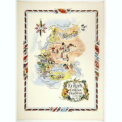
L'Europe Centrale et Orientale.
Pictorial tourism poster of central and eastern Europe, showing different life scenes relative to the culture's country.Learn more about pictorial maps. [+]
- $100 / ≈ €94
Place & Date: Paris, 1951
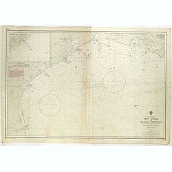
Gulf of Mexico. Ship Shoal to Brazos Santiago.
A large sea chart of the Gulf of Mexico, Ship Shoal to Brazos Santiago, 'from Admiralty Charts and US Government charts, corrected to 1943'. (In fact there are correction...
- $200 / ≈ €187
Place & Date: London, 1943 updated to 1951
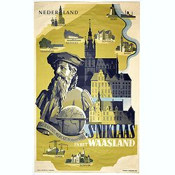
Sint Niklaas en het Waasland Gerardus Mercator Museum.
Poster showing a portrait of Gerard Mercator, set behind a globe and the town hall of St. Niklaas. Showing a map of the region containing pictorial vignets of Overmere, K...
- $500 / ≈ €468
Place & Date: Brussels, 1951
![[ Pictorial world map ]](/uploads/cache/44376-250x250.jpg)
[ Pictorial world map ]
Pictorial world map includes decorative title cartouche and compass rose. Drawn by Jacques Liozu, a French illustrator who drew a number of maps in this style in 1951, in...
- $220 / ≈ €206
Place & Date: Paris, 1951
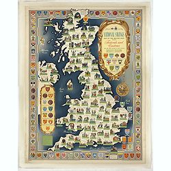
National saving map og the British Isles . . .
A brilliantly eccentric poster showing the festivals, customs of the British Isles with the arms and seals of the counties.Founded in 1861, National Savings is a state-ow...
- $450 / ≈ €421
Place & Date: London, 1951
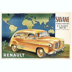
Renault Savane 1951 L. La nouvelle voiture mixte 6 / 7 places 800 kg moteur
Original advertising poster for the French car brand Renault, printed by Barreau.Read more about Poster History [+]
Place & Date: Paris, 1951
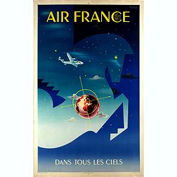
Air France dans tous les ciels.
Original lithograph advertising poster for Air France, by Badia Vilato Xavier. Signed in the upper right corner. The poster has always occupied a special place in Air Fra...
Place & Date: Imprimerie Perceval, Paris, 1951
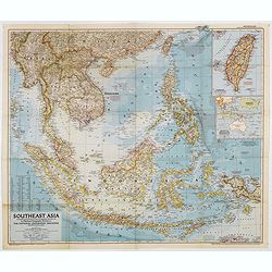
Southeast Asia Compiled and Drawn in the Cartographic Section of the National Geographic Society for the National Geographic Magazin Gilbert Grosvenor. . .
Map of the Southeast Asia, with inset map of Taiwan an map with Australia. The first issue of National Geographic Magazine was published on September 22, 1888, nine month...
Place & Date: Washington, 1952
Selling price: $50
Sold in 2018
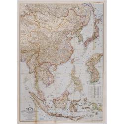
The Far East Compiled and Drawn in the Cartographic Section of the National Geographic Society for the National Geographic Magazine Gilbert Grosvenor. . .
Map of Far East Asia, with inset map of Korea. Scale 1:7.500.000. The first issue of National Geographic Magazine was published on September 22, 1888, nine months after t...
- $75 / ≈ €70
Place & Date: Washington, 1952
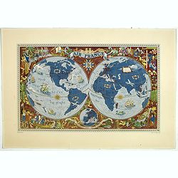
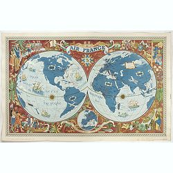
AIR France - Sur les ailes d'Air France découvrez le monde à votre tour.
Promotional poster of a double hemisphere world map designed by Lucien Boucher for AIR France. The map depicts the entire world in rich blues and burgundies with gold hig...
- $750 / ≈ €702
Place & Date: Perceval, Paris, 1952

A map of the British Army with battle honours and militray achievements and Regimental Badges . . .
Shows English County Regiments, Battle Honours and Military Achievements. Bordered by Regimental Badges.A fascinating piece of British history.Read more about Pictorial M...
Place & Date: London, 1952
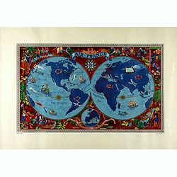
Sur les ailes d'Air France découvrez le monde à votre tour.
Promotional mid-size poster of a double hemisphere world map designed by Lucien Boucher for AIR France. The map depicts the entire world in rich blues and burgundies with...
- $1100 / ≈ €1029
Place & Date: Imprimerie Goosens, Paris, 1952
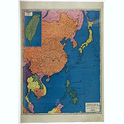
Political Map of Asiatic Coastal Area.
A strongly colored, large map of the Asiatic Coastal countries. All countries are color coded. Maps coverage is from China and Japan in the north, south to the tips of Su...
- $450 / ≈ €421
Place & Date: Chicago, ca 1952
AIR France - Sur les ailes d'Air France découvrez le monde à votre tour.
Promotional poster of a double hemisphere world map designed by Lucien Boucher for AIR France. The map depicts the entire world in rich blues and burgundies with gold hig...
Place & Date: Perceval, Paris, 1952
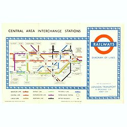
1953 Harry Beck London Underground map.
Published in the Queen's coronation year. A London Underground map (double sided).
- $150 / ≈ €140
Place & Date: London, 1953
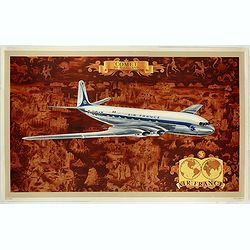
AIR France - Comet De Havilland
Promotional poster attributed to Lucien Boucher showing the Comet de Havilland on a Mercator projection world map. The map depicts a pictorial map of the entire world in ...
- $1600 / ≈ €1497
Place & Date: Perceval, Paris, 1953
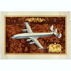
AIR France - Super constellation, Lockhead L - 10 - 49.
Promotional poster attributed to Lucien Boucher showing of a Lockhead L - 10 - 49 on a Mercator projection world map. The map depicts a pictorial map of the entire world ...
Place & Date: Perceval, Paris, 1953
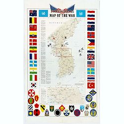
Pacific Stars and Strips Map of the War.
A detailed map of the Korean War. Several silhouetted flying military aircraft are shown in formation. The map shows the Korean Peninsula from its northern border with Ru...
Place & Date: America, 1953
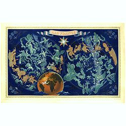
![AIR France [Planisphère Air France Zodiac].](/uploads/cache/46994-250x250.jpg)
AIR France [Planisphère Air France Zodiac].
A double-hemisphere celestial map with the constellations of the zodiac in gold and the others in turquoise, set against a sky of navy blue, both with the major stars mar...
- $2200 / ≈ €2059
Place & Date: Imprimerie Perceval, Paris, 1953

(World map). Americus Vespucio novo te Duce Ducta Freto Ambivi Meritoqs Vocor.
Manuscript world map showing the American and African continent and the southern parts of Asia. In the Indian Ocean a large depiction of Amerigo Vespucci 1454 – 1512) o...
Place & Date: Italy, ca. 1954
![[Set of 2 maps] The Pageant of History in Northern California its colorful and adventuresome beginnings / The Panorama of Today in Northern California its resources, activities and opportunities.](/uploads/cache/48343A-250x250.jpg)
[Set of 2 maps] The Pageant of History in Northern California its colorful and adventuresome beginnings / The Panorama of Today in Northern California its resources, activities and opportunities.
An unusual and attractive pair of lithographed maps, issued by the American Trust Company, in San Francisco on the occasion of its centenary in 1954. It chose to do this ...
- $350 / ≈ €328
Place & Date: San Francisco, 1954
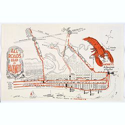
Map of Atlantic City to Hackney's Famous Garden of Sea Food . . .
A mid 1950s brochure for the famous Atlantic City Seafood Restaurant - 'Hackneys'. One side proclaims that "All Roads lead to Hackney's". It shows a nice plan o...
- $50 / ≈ €47
Place & Date: New Jersey, ca 1954
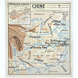
Chine - Angleterre.
A large, vintage French school poster map from the 1950s, showing China on one side and the United Kingdom on the reverse. As you would expect content and detail and basi...
Place & Date: Nalliers, ca 1955
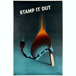
Stamp it out.
colorful 'Keep Alert" poster by Leonard Cusden (1950s), made for the "The Royal Society For The Prevention of Accidents" in London.Leonard Cusden (1928-193...
- $200 / ≈ €187
Place & Date: London, ca. 1955
![Air France [poster].](/uploads/cache/44299-250x250.jpg)
Air France [poster].
A superb double-sided Air France folding poster, featuring bold colored graphics. Published as a serious piece of marketing put out by the airline showing off their state...
- $500 / ≈ €468
Place & Date: Paris, 1955
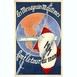
Les Messageries Maritimes font le tour du monde.
Original lithographed poster created by the artist Robert Louis Antral for Les Messageries Maritimes, showing a boat and a globe. Les Messageries Maritimes Company (MM) i...
- $900 / ≈ €842
Place & Date: Paris, 1955
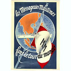
Les Messageries Maritimes font le tour du monde.
Original lithographed mini poster (570 x 400mm.) created by the artist Robert Louis Antral for Les Messageries Maritimes, showing a boat and a globe. Les Messageries Mari...
Place & Date: Paris, 1955
![Air France [poster].](/uploads/cache/44696-250x250.jpg)
Air France [poster].
A superb double sided Air France folding poster, featuring bold colored graphics. Published as a serious piece of marketing put out by the airline showing off their state...
- $500 / ≈ €468
Place & Date: Paris, 1955

Indonesia.
Original vintage travel advertising issued by the Indonesian Council for Tourism featuring a colorful pictorial map marking the islands and oceans with images of local pe...
Place & Date: Jakarta, ca. 1955
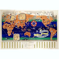
Le tour du monde en 120 images, grand concours du Chocolat Menier.
Pictorial map of the world centered on the Pacific with a route around the globe, starting and finishing in Paris. The map features 120 images of explorers, plants, anima...
- $750 / ≈ €702
Place & Date: Paris, 1956
Le Tour du Monde en 120 Images Grand Concours du Chocolat Menier.
This highly unusual and rather novel pictorial map of the world was created by J.B. Jannot and published by Agence Française de Propagande as a promotional item for Meni...
Place & Date: Paris, 1956
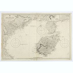
China sea. Tong King Gulf Compiled from the latest British and Foreign Government surveys to 1886. . .
Detailed Map of Chart of Annam Gulf or Tong King Gulf, in the China Sea. Chart with legend and scale. British Admiralty chart No. 2062, published June 1881, large correct...
- $400 / ≈ €374
Place & Date: London, 1881 updated to 1957
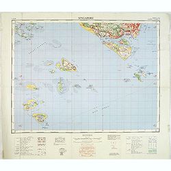
Singapore. - Sheet 134h Keppel harbour.
Map of Singapore. Map with legend and scale. According to a note "Prepared under the direction of the Surveyor General Malaya from the following sources materials : ...
- $750 / ≈ €702
Place & Date: Kuala Lumpur, 1958
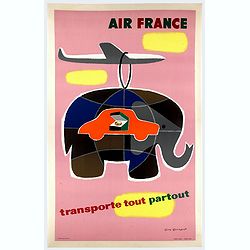
Air France transporte tout partout.
Nice poster designed by Guy Georget, promoting the freight service of Air France.Guy Georget (1911-1992), was a French poster designer and illustrator. Georget's first co...
- $900 / ≈ €842
Place & Date: Perceval, Paris, 1958

AIR France - Le plus grand réseau du monde.
Created in 1959 by the artist Lucien Boucher, showing all of the DC-7 Air France Routes. The Blue Pink Poster is one of a series of eight posters commissioned by Air Fran...
Place & Date: Imprimerie Perceval, Paris, 1959
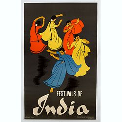
Festivals of India.
A large eye-catching poster of five women, dancing against a black background, dressed in stunning sari's of red, yellow and blue, produced in India by the Government, wi...
- $750 / ≈ €702
Place & Date: Calcutta, 1959

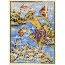
Balinees watercolor on paper, fisherman.
Decorative export painting from Bali of a more than average quality.
- $150 / ≈ €140
Place & Date: Bali, ca 1960
Balinees watercolor on paper, fishermen.
Decorative export painting from Bali of a more than average quality.
- $150 / ≈ €140
Place & Date: Bali, ca 1960

Balinees watercolor on paper, fishermen.
Decorative export painting from Bali of a more than average quality.
- $150 / ≈ €140
Place & Date: Bali, ca 1960

Forteresse Ile Ste Marguerite.
Nice drawing of a stronghold Ste Marguerite. The Île Sainte-Marguerite is the largest of the Lérins Islands, about half a mile off shore from the French Riviera town of...
Place & Date: France, Provence, after 1960
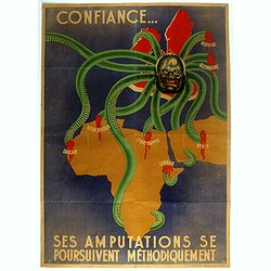
Ses Amputations se Poursuivent Methodiquement.
Propaganda map, produced under the NAZI collaborating Vichy French regime and designed to inspire revulsion and hatred of the English among the French, while frequently d...
Place & Date: Paris, ca. 1941 / ca. 1960
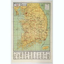
The Road Map of Southern Korea.
Offset printing. A large scale, comprehensive road map of South Korea, with a symbol legend and an inset map of 'The Republic of Korea', and inset of the island of Jeju D...
- $200 / ≈ €187
Place & Date: Seoul, ca 1960
![[TAI travel poster]](/uploads/cache/44304-250x250.jpg)
[TAI travel poster]
A whimsical travel poster for "Transport Aeriens Intercontinentaux" (TAI), published in Paris in 1960, by Luc-Marie Bayle (1914-2000). The poster depicts a twin...
Place & Date: Paris, 1960
![[Fan shaped shopping guide to Stockholm.]](/uploads/cache/44788-250x250.jpg)
[Fan shaped shopping guide to Stockholm.]
A highly unusual and interesting vintage fan-shaped map of Stockholm to illustrate a 'Shopping guide to Stockholm'. Text written in English. With ten fold-out panels prin...
- $200 / ≈ €187
Place & Date: Stockholm, 1960
![[TAI travel poster]](/uploads/cache/44893-250x250.jpg)
[TAI travel poster]
A whimsical travel poster for "Transport Aeriens Intercontinentaux" (TAI), published in Paris in 1960, by Luc-Marie Bayle (1914-2000). The poster depicts a twin...
- $700 / ≈ €655
Place & Date: Paris, 1960
![[TAI travel poster]](/uploads/cache/44894-250x250.jpg)
[TAI travel poster]
A whimsical travel poster for "Transport Aeriens Intercontinentaux" (TAI), published in Paris in 1960, design by François Lesourt (Périgueux, 1913 - 1997). Th...
Place & Date: Paris, Hubert Baille & Cie Paris, 1960
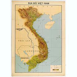
Dia-Do Viet-Nam.
Economic map of Vietnam published in 1960 (not for sale), gift from Japan paper committee. Scale : 1:2 400 000. With a key at lower right part.Features Vietnam, Cambodia,...
Place & Date: 1960
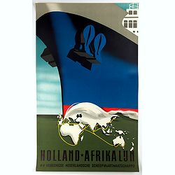
Holland-Afrika Lijn.
Original cruise ship travel poster promoting Holland-Afrika Lijn for the N.V. Veenigde Nederlandse Scheepvaarts Maatschappij. Great illustration by the Dutch graphic arti...
- $850 / ≈ €795
Place & Date: Rotterdam, Kuhn & Zoon, ca. 1960
![[No title] Gouache of a class scene with globe, revolting students and a teacher.](/uploads/cache/44404-250x250.jpg)
[No title] Gouache of a class scene with globe, revolting students and a teacher.
Gouache of a class scene with a globe centered on Europe and Africa with revolting students and a teacher. Original design for a pulp publication.
- $350 / ≈ €328
Place & Date: ca. 1950-1960
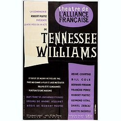
Spectacle Tennessee Williams composé de quatre pièces en 1 acte.
Theater poster for Tennessee Williams plays at the Theatre de l'Alliance Française in 1960. Poster printed in black and purple with design by K.Fernau. Playwright Tennes...
Place & Date: Paris, Lescaret, 1960
![[Pictorial map of Georgia (Caucasus)].](/uploads/cache/44292-250x250.jpg)
[Pictorial map of Georgia (Caucasus)].
A scarce pictorial map of a region in Georgia in the Caucasus. Map is entirely in Russian, complete with legend at base of map, with small thumbnail pictures and symbols ...
- $150 / ≈ €140
Place & Date: Moscow, 1963
![[Pictorial map of Georgia (Caucasus)].](/uploads/cache/47135-250x250.jpg)
[Pictorial map of Georgia (Caucasus)].
A scarce pictorial map of a region in Georgia in the Caucasus. Map is entirely in Russian, complete with legend at base of map, with small thumbnail pictures and symbols ...
- $150 / ≈ €140
Place & Date: Moscow, 1963
![[In Arabic, translates : A map of the United States of America shows its major regional ressources and its natural products]](/uploads/cache/43010-250x250.jpg)
[In Arabic, translates : A map of the United States of America shows its major regional ressources and its natural products]
Chromolithographed pictorial poster of the United States in Arabic language. Showing the United States' main products, regional resources and physical features. The map i...
Place & Date: Washington D.C., ca. 1965
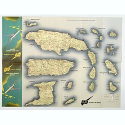
BWIA. North America - Caribbean Route Map.
An interesting double-sided brochure-type map of the routes flown by BWIA (British West Indian Airlines) between North America and the Caribbean. One side shows (not in t...
- $110 / ≈ €103
Place & Date: USA, ca 1960-1965
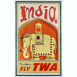
India
This India poster was created circa 1960 by David Klein (1918 -2005) for TWA. The image shows an Indian wall relief with an elephant decorated with precious stones. Eleph...
- $1400 / ≈ €1310
Place & Date: 1965
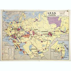
U.S.S.R. Carte Physique. / U.S.S.R. Carte Population.
An unusual school map with on one side a physical map of Russia on verso a map of Russia according to population. Prepared by Pierre Serryn (1916-2002) who was professor ...
- $200 / ≈ €187
Place & Date: St-Germain-en-Laye, 1965
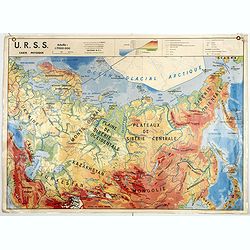
U.S.S.R. Carte Agricole. / U.S.S.R. Carte Industries et communications.
An unusual school map with on one side an agricultural map of Russia on verso a map of Russia showing communication an according to population. Prepared by Pierre Serryn ...
- $200 / ≈ €187
Place & Date: St-Germain-en-Laye, 1965
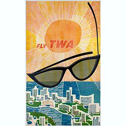
Fly TWA (Miami).
This Miami poster was created in the early 1960's by David Klein (1918 -2005) for TWA. It depicts “hotel row” along Collins Avenue leading to the corridor of South Be...
Place & Date: 1965
![[Russian propaganda poster].](/uploads/cache/44942-250x250.jpg)
[Russian propaganda poster].
Original vintage Soviet propaganda poster for the 25th Anniversary of the Destruction of Fascist Troops in the Battle of Moscow featuring a dynamic image in shades of bla...
- $1500 / ≈ €1404
Place & Date: Russia, 1966
![[US Army map of a part of Vietnam.]](/uploads/cache/44790-250x250.jpg)
[US Army map of a part of Vietnam.]
A large aerial US Army map of a portion of Vietnam, taken during the war between the two countries. As you might expect the map is highly detailed, highlighting settlemen...
- $150 / ≈ €140
Place & Date: Washington D.C., 1967
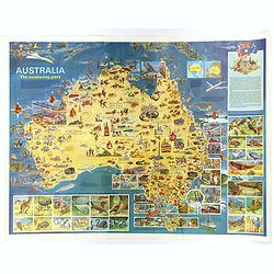
Australia, The Awakening Giant.
This large, fully colored map of Australia was published in America and Australia in the late 1960s. The map is covered in small colored illustrations, connected with loc...
Place & Date: Victoria, 1967
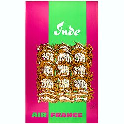
Inde.
Decorative poster advertising flights to India made by Georges Mathieu. The poster is one of a series of 15 composed of posters of Greece, Israel, Germany, Great Britain,...
Place & Date: Paris, 1967

Japan (poster signed by Georges Mathieu)
Dedicated "Pour Benijs Boulanger" and signed "Georges Mathieu", in black marker. Decorative poster advertising flights to Japan made by Georges Mathie...
Place & Date: Paris, 1967