Browse Listings in Asia
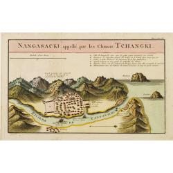
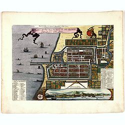
Nangasaki appellé par les Chinois Tchangki.
Attractive bird's-eye view of Nagasaki, with reference key to principal points of interest, including the Dutch V.O.C. Company House. The Dutch/Chinese enclave is central...
- $250 / ≈ €212
Date: Paris, 1727

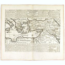
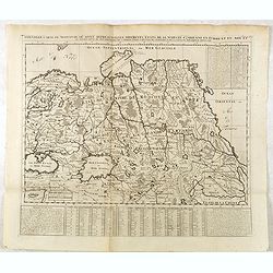
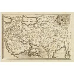
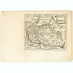
Great or Asiatick Tartary, Agreable to Modern History.
Map of Tartary to Peking. The eastern coastline of Asia is almost flat, with no attempt to mark Kamchatka.
- $275 / ≈ €234
Date: London, 1727
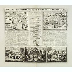
Genealogie des anciens empereurs mogols,. . .
Text sheet with two inset maps of "Carte de l'empire du grand Mogol (122x158mm.) and inset map of Kahsmire "carte nouvelle du royaume de Kachemire" (120x15...
- $150 / ≈ €127
Date: Amsterdam, 1728
![[No title] Mongol.](/uploads/cache/39729-250x250.jpg)
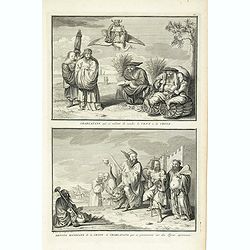
[No title] Mongol.
Interesting sheet with four detailed engravings illustrating Mongol's life scenes. In upper right margin: 'Tom. V. No 43. Pag: 116.Henri Abraham Chatelain (1684 – 1743)...
Date: Amsterdam, 1728
![[No title] Hindou](/uploads/cache/39730-250x250.jpg)
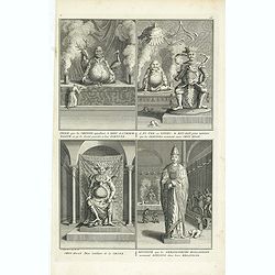
[No title] Hindou
Interesting sheet with four detailed engravings illustrating Hindou's life scenes. In upper right margin: 'Tom. V. No 42. Pag: 116.Henri Abraham Chatelain (1684 – 1743)...
Date: Amsterdam, 1728
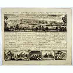
Vue & discription de la Ville de Jerusalem..avec Tombeaux..
This copper-engraving shows a panoramic view of Jerusalem, two insets of mount "Liban" and three insets of the tombs De Zacharie, Des Rois, and D'Absalom.Zachar...
- $400 / ≈ €340
Date: Amsterdam, 1728
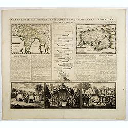
Genealogie des empereurs Mogols . . .
Text sheet with two inset maps of "Carte de l'empire du grand Mogol (122x158mm.) and inset map of Kahsmire "carte nouvelle du royaume de Kachemire" (120x15...
- $150 / ≈ €127
Date: Amsterdam, 1728

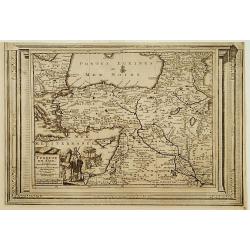
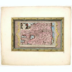
Carte nouvelle des Terres de Cucan..
Prepared by H.Reland (1676-1718) a professor active in Utrecht and specialized in Asian languages, geography and religions. His first map was a map of Japan copied after ...
Date: The Hague, 1728
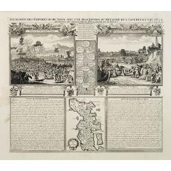
Succession Des Empereurs Du Japon Avec Une Description Du Meurtre De L'Empereur Cubo Et La Reception Des Ambassadeurs Hollandais En Ce Pays . . .
Composite sheet, with a small map of Japan and two detailed views: one depicting the murder of the Emperor Cubo, the other, the reception of the Dutch ambassadors, each w...
- $300 / ≈ €255
Date: Amsterdam, 1728
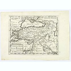
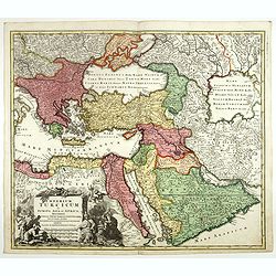
Turquie en Asie, suivant les nouvelles observations..
Uncommon edition of this map of Turkey, Holy Land, Armenia, including Cyprus. With decorative title cartouche lower left corner.This example is unusual in having the addi...
Date: Leiden, 1728
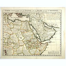
Carte Particuliere De L'Egypte, De La Nubie et de L'Abyssinie, Dressee sur les Memoires les plus Nouveaux & les Observation les plus exactes.
Including the Arabian Peninsular, Egypt, north eastern part of Africa, Cyprus and part of the Mediterranean.Based on the work of Guillaume Delisle. It is a very detailed ...
- $400 / ≈ €340
Date: Amsterdam, 1728
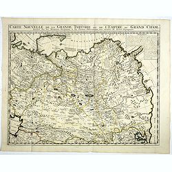
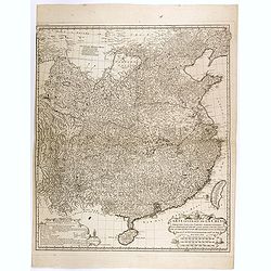
Carte Nouvelle de la Grande Tartarie ou de l'Empire du du Grand Cham. . .
Very detailed map of Northern China, Korea, Russia in the north the Murmansk Sea. Including the western coast of Nova Zembla. Zacharie Chatelain (d.1723) was the father o...
- $250 / ≈ €212
Date: Amsterdam, 1728
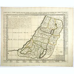
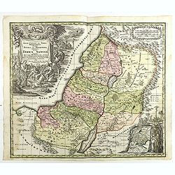
Carte de la Terre Sainte Divisée dans toutes ses parties. . .
A finely engraved map depicting the division of the Holy Land into twelve tribes.Zacharie Chatelain (d.1723) was the father of Henri Abraham (1684-1743) and Zacharie Juni...
- $350 / ≈ €297
Date: Amsterdam, 1728

Habillement de l'Empereur de la Chine & des Dames de son Palais..
This impressive engraving is a wonderful example of Chatelain’s elegant plates.Divided in 3 panels, showing examples of costumes of Chinese ladies and those of the king...
Date: Amsterdam, ca. 1728
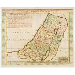
Carte de la Terre Sainte Divisée dans toutes ses. . .
A finely engraved map depicting the division of the Holy Land into twelve tribes.
- $400 / ≈ €340
Date: Amsterdam, 1728

L'Inde de la le Gange, suivant les nouvelles observations...
Uncommon edition of this map of Malaysia, Thailand, Indo China and the Northern parts of the islands of Sumatra and Borneo. Singapore marked as Sincapour. With decorative...
Date: Amsterdam, 1728

L'Asie suivant les nouvelles observations...
Uncommon edition of this map of Asia. From Le Nouveau Theatre du Monde, ou la Geographie Royale.The map is of interest for the use of Mer Orientale, the sea between Kor...
Date: Amsterdam, 1728
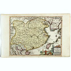
La Chine suivant les nouvelles observations...
Uncommon edition of this map of China. From Le Nouveau Theatre du Monde, ou la Geographie Royale.Curious shape of South Korea.
- $1100 / ≈ €935
Date: Amsterdam, 1728
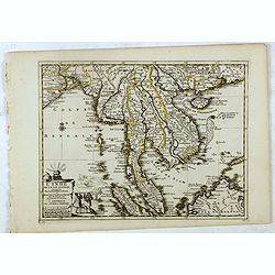
L'Inde de la le Gange, suivant les nouvelles observations...
Decorative map of Malaysia, Thailand, Indo-China, and the Northern parts of the islands of Sumatra and Borneo. Singapore marked as Sincapour.Originally published by Piete...
Date: Amsterdam, 1728
Carte historique et géographique pour servir à l'Histoire Sainte et à la Vocation de Saint Paul, avec quelques remarques curieuses pour servir à l'Histoire des Antiquités judaïques.
Interesting sheet with a map of the travels of Saint Paul, including eastern part of Europe, Asian continent and part of north Africa, with descriptive French text, from ...
Date: Amsterdam, 1728
Turkey in Asia: or Asia Minor &c.
Herman Moll's map of the Turkish Empire in Asia, published in London during the first half of the eighteenth century. It shows the eastern Mediterranean, including Crete ...
- $150 / ≈ €127
Date: London, ca 1729
Historic Map - Naaukeurige Kaart Van Tartaryen, Soo als dat door W De Rubruquis doorreyst.
This attractive map published by Pieter van der Aa, shows Tartary abd the ancient Silk Road region. The map shows the track of William of Rubruck (Willem van Rubroeck or ...
Date: Amsterdam, 1713-1729

Histoire Naturelle, Civile, Et Ecclésiastique..'
First French edition, published by P. Gosse, J. Neaulme and B. Lakeman. The basic work on Japan from the second half of the 17th century when it was still forbidden for f...
Date: Amsterdam, 1729
Terra Sancta vocata quae olim XII tribus . . .
Map of the Holy Land, among the 12 Tribes and divided into 6 provinces. In the upper left near the title cartouche Pharaoh's daughter discovers Moses in the River Nile. O...
Date: Augsburg, 1730
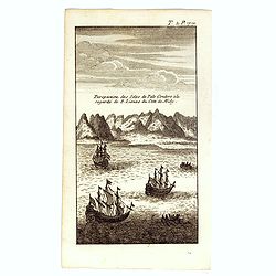
Perspective des Isles de Palo Condoro à le regarde de 8 lieües di coté de Midy.
An attractive view of the Isle de Condor (Côn Son Island), located off the southern tip of Vietnam and a victualing point by European traders. In 1702, the English East ...
- $150 / ≈ €127
Date: Paris / Amsterdam, ca 1730
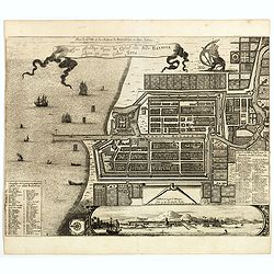
Plan de la Ville et du Chateau de Batavia en l'Isle de Iava / Ware affbeeldinge wegens het Casteel ende Stadt Batavia gelegen opt groot Eylant Java.
Detailed East-oriented plan of Jakarta former Batavia on Java / Indonesia. With bird's-eye view from sea side, various ships and a lion. Two inset keys with detailed desc...
Date: Leiden, 1730
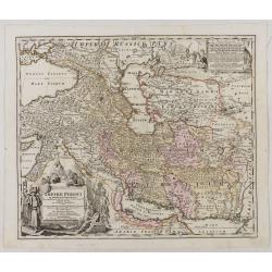
Imperii Persici in omnes suas Provincias . . . Exacte Divisi Nova Tabula Geographica. . .
Showing the eastern part of Turkey and Cyprus, Palestine, Persian Gulf, including Gulf of Oman, Caspian Sea, Iran and the north-west territories of India.Embellished with...
Date: Ausburg, 1730
![[Lot of 10 maps] Carte Nouvelle de la Grande Tartary.](/uploads/cache/100265-(1)-250x250.jpg)
[Lot of 10 maps] Carte Nouvelle de la Grande Tartary.
Antique map of Asian Russia] Carte Nouvelle de la Grande Tartarie ou de l'Empire du Grand Cham. With 10 maps / views of Asian Russia- Carte Nouvelle de la Grande Tartari...
Date: Amsterdam, 1720 - 1730
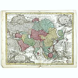
Asia Cum omnibus Imperiis, Provinciis, Statibus et Insulis. . .
A finely engraved and decorative mid-18th century map published in Augsburg, Germany and incorporating two large decorative title cartouches upper right and bottom left. ...
- $250 / ≈ €212
Date: Augsburg, 1730

Insularum Moluccarum Nova description.
Exquisite map of the famous Spice Islands based. This map was the first large-scale map of the region and depicts the islands which provided first the Portuguese and then...
Date: Amsterdam, 1730
Plan de la Ville et du Chateau de Batavia en l'Isle de Iava / Ware affbeeldinge wegens het Casteel ende Stadt Batavia gelegen opt groot Eylant Java.
Detailed East-oriented plan of Jakarta former Batavia on Java / Indonesia. With a bird's eye view from seaside, various ships and a lion. Two inset keys with detailed des...
- $750 / ≈ €637
Date: Leiden, 1730
Plan de la Ville et du Chateau de Batavia en l'Isle de Iava / Ware affbeeldinge wegens het Casteel ende Stadt Batavia gelegen opt groot Eylant Java.
Detailed East oriented plan of Jakarta former Batavia on Java / Indonesia. With bird eye view from sea side, various ships and a lion. Two inset keys with detailed descri...
Date: Leiden, 1730

Alexandri Magni Imperium et Expeditio. . .
The map represents the theatre of Alexander the Great's conquests between the Black Sea and Indus River, today's Turkey, Armenia, Iraq, Iran, Afghanistan, etc. The map is...
- $100 / ≈ €85
Date: Paris, 1731
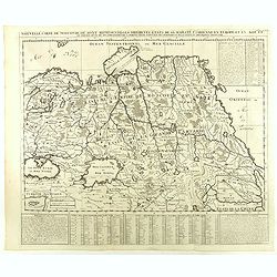
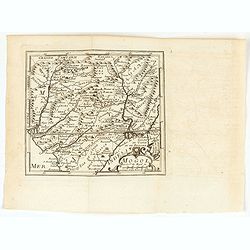
Nouvelle Carte de Moscovie où sont representés les differents etats de sa Maiesté Czarienne..
Map of Russia Tartary and part of China with key tables to the towns. Depicting the different states belonging to the Czar in Asia and Europe, showing the path of one of ...
- $200 / ≈ €170
Date: Amsterdam, ca. 1732
Great Tartary, with the tract of the Moscovite Ambassador's Travels from Moscow to Pekin in China.
An interesting map illustrating the route taken by the Russian Ambassador on his travels east to Beijing. Shows the Great Wall, "Somer Houses" and "parts u...
- $125 / ≈ €106
Date: London, 1732
Oriens, Persia, India etc.
Uncommon map of Persia, Armenia, Arabian Peninsular and part of India. Prepared by Christoph Cellarius (1638-1707). From Geographia Antiqua...
Date: Leipzig, Gledisch, 1732

Vorstellung der Evangelisch-Ostindischen Kirche Augsburger Protestanten.
It is a very decorative and rare print to commemorate the 200-year Confession of the Augsburg Protestant Confession. Engraved by J. Kleinschmidt after a design of E. Ridi...
Date: Augsburg, 1732
Nouvelle Carte de Moscovie où sont representés les differents etats de sa Maiesté Czarienne. . .
Map of Russia Tartary and part of China with key tables to the towns. Depicting the different states belonging to the Czar in Asia and Europe, showing the path of one of ...
- $250 / ≈ €212
Date: Amsterdam, ca. 1732

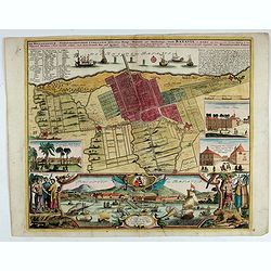
Der Hollaendisch-Ostindianischen Compagnie Weltberühmte Haupt - Handels und Niederlags stadt BATAVIA..
Very fine decorative plan of Batavia showing the City and its immediate environs, the surrounding rice fields intersected by a network of waterways, canals and outlying f...
Date: Nuremberg, 1733
Der Hollaendisch-Ostindianischen Compagnie Weltberühmte Haupt - Handels und Niederlags stadt BATAVIA..
A very fine decorative plan of Batavia showing the City and its immediate environs, the surrounding rice fields intersected by a network of waterways, canals and outlying...
Date: Nuremberg, 1733

Hedendaegsche Historie of tegenwoordige staet van alle volkeren 1 deel. (Volume 1 - China, Japan, Phillippines, Moluccas)
This provides an interesting illustrated description of China, Japan, the Phillippines, Moluccas. Including a map of China, Korea, and Japan, with the Sea between Korea a...
Date: Amsterdam, 1734
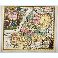
Regio Canaan seu Terra Promissionis postra Judeae vel Palaestina nominata hodiae Terra Sancta. . .
A striking and beautiful map of The Holy Land and Judea divided up into the twelve tribes. These are easily distinguished by the use of bold, rich period wash colour. Wit...
- $600 / ≈ €510
Date: Augsburg, ca 1734
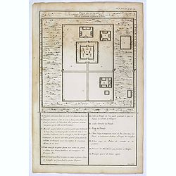
Plan du Ti-tang ou du temple, où l'empereur sacrifie à Chang-ti sous le titre de souverain seigneur de la terre
A plan of the temple of the soil god (社稷壇, Shèjìtán, "Altar of Soil and Grain")—under the name "Titang" (地堂, dìtáng, "Hall of Di...
Date: Paris, P.G. Le Mercier, 1735
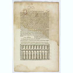
Souan pan, ou instrument dont les chinois se servent pour compter.
Text page with a wood block illustration of a souan-pan [suan-p'an] the calculation table used by the Chinese. Jean Baptiste Bourguignon d' Anville (1697-1782), French c...
Date: Paris, P.G. Le Mercier, 1735
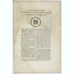
Carte du ciel et de la terre qui commencent à se former / Figure du ciel fluide & pur & de la terre fixe & ferme.
Recto and verso text page with two illustrations of the grounding of the sky and earth according to a Chinese philosopher. Jean Baptiste Bourguignon d' Anville (1697-178...
- $75 / ≈ €64
Date: Paris, P.G. Le Mercier, 1735
![Province de Ho-nan. [Honan 河南 (Hénán) province]](/uploads/cache/39696-250x250.jpg)
Province de Ho-nan. [Honan 河南 (Hénán) province]
An important map of Honan 河南 (Hénán) province. With a quite elaborately pictorial cartouche, engraved by F.Baillieul Lainé. Jean Baptiste Bourguignon d' Anville (1...
- $200 / ≈ €170
Date: Paris, P.G. Le Mercier, 1735
![Province de Se-Tchuen. [ Se-tchuen 四川 [Sichuan] province.]](/uploads/cache/39699-250x250.jpg)
Province de Se-Tchuen. [ Se-tchuen 四川 [Sichuan] province.]
Important map of Se-tchuen 四川 [Sichuan] province. With a quite elaborately pictorial cartouche, engraved by Guélard, the map by Delahaye, features animals, birds, a ...
- $450 / ≈ €382
Date: Paris, P.G. Le Mercier, 1735
![Province de Chan-Si. [Chan-s 山西i [Shanxi] province. ]](/uploads/cache/39697-250x250.jpg)
Province de Chan-Si. [Chan-s 山西i [Shanxi] province. ]
An important map of Chan-s 山西i [Shanxi] province. With a quite elaborately pictorial cartouche, engraved by Guélard, the map by Delahaye. Jean Baptiste Bourguignon d...
- $200 / ≈ €170
Date: Paris, P.G. Le Mercier, 1735
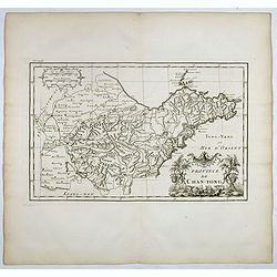
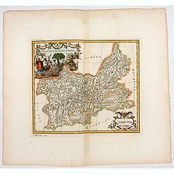
Province de Chan-Tong.
Detailed map of Shandong Province. With a quite elaborately pictorial cartouche, engraved by Guélard, the map by Delahaye, featuring a rabbit and rococo chinoiserie orna...
- $300 / ≈ €255
Date: Paris, P.G. Le Mercier, 1735
![Province de Hou-Quang. [Hou-quang 湖广 [Huguang] province.]](/uploads/cache/39694-250x250.jpg)
Province de Hou-Quang. [Hou-quang 湖广 [Huguang] province.]
Important map of Hou-quang 湖广 [Huguang] province. With a quite elaborately pictorial cartouche, engraved by Guélard, the map engraved by F.Baillieul Lainé, featurin...
- $250 / ≈ €212
Date: Paris, P.G. Le Mercier, 1735
![Province de Tche Kiang. [Tche kiang 浙江 [Zhejiang] province]](/uploads/cache/39693-250x250.jpg)
Province de Tche Kiang. [Tche kiang 浙江 [Zhejiang] province]
D'Anville's highly detailed map of Tche kiang 浙江 [Zhejiang] province from du Halde's "Description geographique historique...de l'Empire de la Chine et de la Tart...
- $400 / ≈ €340
Date: Paris, P.G. Le Mercier, 1735
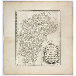
Province de Kiang-Si. Jiangxi 江西 province.
An important map of Jiangxi 江西 province. With a quite elaborately pictorial cartouche featuring a rococo chinoiserie ornamentation, engraved by Guélard. The map itse...
- $200 / ≈ €170
Date: Paris, P.G. Le Mercier, 1735
![Province de Pe-Tche-Li. Pe-tche-li [Beizhili] 北直隶 [= 河北]. province.]](/uploads/cache/39689-250x250.jpg)
Province de Pe-Tche-Li. Pe-tche-li [Beizhili] 北直隶 [= 河北]. province.]
Important map of Pe-tche-li [Beizhili] 北直隶 [= 河北]. With a quite elaborately pictorial cartouche featuring a rococo chinoiserie ornamentation, engraved by Guéla...
- $300 / ≈ €255
Date: Paris, P.G. Le Mercier, 1735
![Province de Koei-Tcheou. [Koei-tcheou 贵州 [Guizhou] province.]](/uploads/cache/39688-250x250.jpg)
Province de Koei-Tcheou. [Koei-tcheou 贵州 [Guizhou] province.]
Important map of Koei-tcheou 贵州 [Guizhou]. With a quite elaborately pictorial cartouche featuring a rococo chinoiserie ornamentation, engraved by Guélard, the map by...
- $300 / ≈ €255
Date: Paris, P.G. Le Mercier, 1735
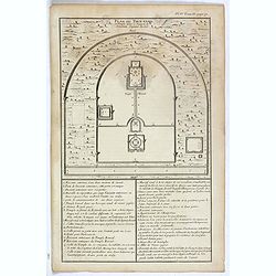
Plan du Tien-tang ou du temple, où l'empereur sacrifie à Chang-ti sous le titre de souverain seigneur de la terre.
Nice example of d'Anville's plan of Tien-tang temple, from "Atlas général de la Chine..."" prepared by Jesuit missionaries and commissioned by Emperor Ka...
Date: Paris, P.G. Le Mercier, 1735
![Carte de la province de Tche kiang 浙江 [Zhejiang]](/uploads/cache/30923-250x250.jpg)
Carte de la province de Tche kiang 浙江 [Zhejiang]
D'Anville's highly detailed map of Tche Kiang (Zhejiang) province from du Halde's "Description geographique historique...de l'Empire de la Chine et de la Tartarie Ch...
- $250 / ≈ €212
Date: Paris, P.G. Le Mercier, 1735
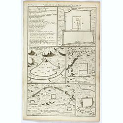
Villes de la province de Petche-li.
Five town plans : Peking (with forbidden town), Yung-ping-fou, Long-men-hien, Yuen-keou/Tching-sse-yu/Si-yang-keou/Hoang-tou-in, Tchin-ting-fou. From "Description ge...
- $150 / ≈ €127
Date: Paris, P.G. Le Mercier, 1735
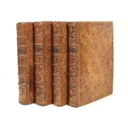
Description geographique, historique, chronologique, politique, et physique de l'empire de la Chine et de la Tartarie chinoise.
Cornerstone of any collection of books on China, which is also among the rarest and most desirable of important Americana.This, "the first definitive European work o...
Date: Paris, P. G. Le Mercier, (vol. 1-3) 1770 / (vol.4),1735
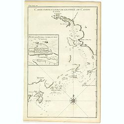
Carte particulière de l'entrée de Canton - Plan de Quang-tcheou-fou vulgo Canton .
Beautiful detailed map of the entrance to the city of Canton, showing also the cities of Macao and Quanghai, as well as the islands of the bay, including the island of Sh...
- $450 / ≈ €382
Date: Paris, P.G. Le Mercier, 1735
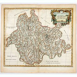
Province d'Yun-Nan.
Important map of Yun-nan 云南 [Yunnan] province. With a quite elaborately pictorial cartouche featuring a rococo chinoiserie ornamentation, engraved by Delahaye. Jean B...
- $100 / ≈ €85
Date: Paris, P.G. Le Mercier, 1735
Province de Koei-Tcheou.
An important map of Koei-tcheou 贵州 [Guizhou]. With a quite elaborately pictorial cartouche featuring a rococo chinoiserie ornamentation engraved by Guélard, the map ...
- $100 / ≈ €85
Date: Paris, P.G. Le Mercier, 1735
Description geographique, historique, chronologique, politique, et physique de l'empire de la Chine et de la Tartarie chinoise.
First edition of this cornerstone of any collection of books on China, which is also among the rarest and most desirable of important Americana, included in Rare American...
Date: Paris, P. G. Le Mercier, 1735
Charlatans qui se mêlent de vendre le vent de la Chine. Dévots mendiants de la Chine et charlatans qui se promènent sur des tigres apprivoisés, . . .
Two fascinating engraving on one sheet depicting Chinese charlatans. Engraved by Bernard Picart. Published in Jean Frederic Bernard's monumental "Cérémonies et cou...
- $150 / ≈ €127
Date: Amsterdam, J.F. Bernard c.1736

Description geographique, historique, chronologique, politique, et physique de l'empire de la Chine et de la Tartarie chinoise . . . du Thibet, & de la Coree. . .
Without the separately published atlas. Lacking 2 plates in vol.2 (Obseques at p.149 and Gin seng at p.180), one plate torn without a loss (vol.1, p.230), d4 vol.1 with a...
Date: The Hague, H. Scheurleer, 1736
Idole que les chinois appellant, le dieu de l´immortalité, et qu´ils disent presider a leur Fortune. . .
Four fascinating engraving on one sheet depicting Chinese gods. "Idole que les chinois appellant, le dieu de l´immortalité, et qu´ils disent presider a leur Fortu...
- $150 / ≈ €127
Date: Amsterdam, J.F. Bernard c.1736

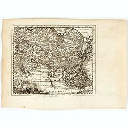
Asia By H.Moll Geographer.
Detailed map of Asia. From his "Atlas minor: or a new and curious set of sixty-two maps. . .", which was first published in 1729 and reprinted in 1732, 1736.The...
Date: London, 1736
![Province de Fo-Kien. [Includes West Coast of Taiwan]](/uploads/cache/43503-250x250.jpg)
Province de Fo-Kien. [Includes West Coast of Taiwan]
An important map of Fujian Province shows the East Coast of China and the West Coast of Taiwan. It shows that for the Manchu Qing, only the western half of Formosa was co...
Date: The Hague, H. Scheurleer, 1737

Nouvel atlas de la Chine, de la Tartarie chinoise, et du Thibet.
First edition of "the principal cartographic authority on China during the 18th century". It was the second major atlas of China produced in Europe following th...
Date: The Hague, H. Scheurleer, 1737

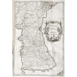
Royaume de Corée.
With a quite elaborately pictorial cartouche, engraved by G.Kondet. One of the earliest separate maps of Korea. Jean Baptiste Bourguignon d' Anville (1697-1782), French c...
Date: The Hague, 1737

Carte la plus generale et qui comprend la Chine, la Tartarie chinoise et le Thibet. . .
It has a quite elaborate pictorial cartouche engraved by G. Kondet. It is a very detailed map of China, Tibet, and Korea.In the upper left corner is very good details of ...
Date: The Hague, 1737
Carte générale de la Chine Dressée sur les Cartes particulières que l'Empereur Cang-hi a fait lever sur les lieux par les RR. PP. Jésuites missionaires dans cet empire / Par le Sr d'Anville.
An essential and very detailed map of the Southern part of China, including a detailed map of Taiwan.Jean Baptiste Bourguignon d' Anville (1697-1782) was a French cartogr...
Date: The Hague, H. Scheurleer, 1737
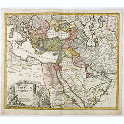
Imperium Turcicum in Europa, Asia et Africa.
Johann Baptist Homann's well-engraved map of the Turkish Empire, showing from Tunis to Arabia, including Greece, Arabia, Turkey and Palestine. With good detail in the Ara...
- $1000 / ≈ €850
Date: Nurnberg, 1737
Imperium Turcicum in Europa, Asia et Africa Regiones proprias, tributarias, clientelares sicut et omnes eusdem Beglirbegatus seu Præfecturas Generales exhibens. . .
Johann Baptist Homann's well-engraved map of the Ottoman Empire centered on Cyprus. With good detail in the Arabian Peninsular. In the lower left, a decorative title cart...
- $500 / ≈ €425
Date: Nurnberg, 1737

'T Eilandje Desima verblyf plaats der Hollanders in Japan.
Bird's-eye view of Dejima copied from a manuscript by Voogt, who was second-in-command on Deshima in 1713. The island is viewed from the landside, depicting the developme...
Date: Amsterdam, 1739
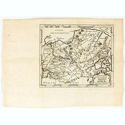
Grande Tartarie.
A very nice map of Tartaria extending from the Caspian Sea to the Pacific Ocean. From Francisco Giustiniani for El Atlas abreviado o el nuevo compendio de la Geografia un...
- $150 / ≈ €127
Date: Leon de Francia (Lyon), Jaime Certa, 1739
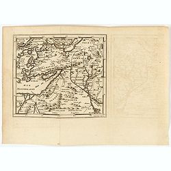
(Arabian peninsula, Turkey, Irak).
A very nice map of the Arabian peninsula, Turkey and Irak. From Francisco Giustiniani for El Atlas abreviado o el nuevo compendio de la Geografia universal, politica, his...
- $150 / ≈ €127
Date: Leon de Francia (Lyon), Jaime Certa, 1739
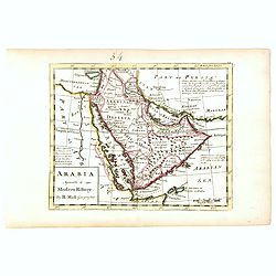
Arabia agreeable to Modern History.
Detailed map of the Arabian Peninsula from the Mediterranean Sea to the Arabian Sea, and western Iran. with an engaging text block on upper right corner: "Arabia, d...
- $550 / ≈ €467
Date: London, 1739
Mogol.
A very nice map of Northern India and Pakistan. From Francisco Giustiniani for El Atlas abreviado o el nuevo compendio de la Geografia universal, politica, historica, i c...
- $150 / ≈ €127
Date: Leon de Francia (Lyon), Jaime Certa, 1739
Perse.
A very nice map of Persia. From Francisco Giustiniani for El Atlas abreviado o el nuevo compendio de la Geografia universal, politica, historica, i curiosa, segun el esta...
- $150 / ≈ €127
Date: Leon de Francia (Lyon), Jaime Certa, 1739
Asiae.
A very nice map of Asia. From Francisco Giustiniani for El Atlas abreviado o el nuevo compendio de la Geografia universal, politica, historica, i curiosa, segun el estado...
- $300 / ≈ €255
Date: Leon de Francia (Lyon), Jaime Certa, 1739