Browse Listings in Asia
![[Map of Turkey in Ottoman script]](/uploads/cache/40765-250x250.jpg)
[Map of Turkey in Ottoman script]
Map of Turkey, including Cyprus, with text in Ottoman script. In the bottom a color key to the different regions. Published by Elbemühl Graphische Industrie in Vienna (f...
Date: Vienna, ca. 1915
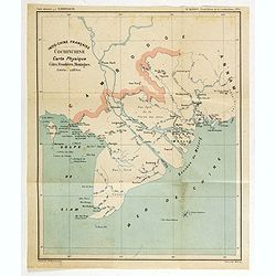
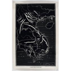
Indo-Chine Française Cochinchine. Carte Physique Côtes, Frontières, Montagnes.
Charming map of the southern third of current Vietnam whose principal city is Saigon or Prey Nokor in Khmer. It was a French colony from 1862 to 1954.Prepared by R.Brissa...
- $150 / ≈ €127
Date: Saigon, Librairie Brunet. c.1920
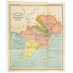
Indo-Chine Française Cochinchine. Régime des Eaux Réseaux.
Charming map of the southern third of current Vietnam whose principal city is Saigon or Prey Nokor in Khmer. It was a French colony from 1862 to 1954.Prepared by R.Brissa...
- $150 / ≈ €127
Date: Saigon, Librairie Brunet. c.1920
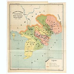
Indo-Chine Française Cochinchine. Carte historique Anciennes Provinces.
Charming map of the southern third of current Vietnam whose principal city is Saigon or Prey Nokor in Khmer. It was a French colony from 1862 to 1954.Prepared by R.Brissa...
- $150 / ≈ €127
Date: Saigon, Librairie Brunet. c.1920
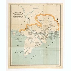
Indo-Chine Française Cochinchine. Productions du Sol Commerce, Industrie.
Charming map of the southern third of current Vietnam whose principal city is Saigon or Prey Nokor in Khmer. It was a French colony from 1862 to 1954.Prepared by R.Brissa...
- $150 / ≈ €127
Date: Saigon, Librairie Brunet. c.1920
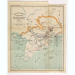
Indo-Chine Française Cochinchine. Voies de Communication Ports Marchants, Défense Phares.
Charming map of the southern third of current Vietnam whose principal city is Saigon or Prey Nokor in Khmer. It was a French colony from 1862 to 1954.Prepared by R.Brissa...
- $150 / ≈ €127
Date: Saigon, Librairie Brunet. c.1920
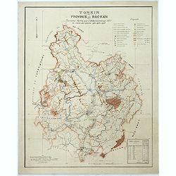
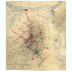
Tonkin Province de Bac-Kan Tournées faites par l'administrateur Blu au cours des années 1921-1922-1923.
Large scale manuscript map (1:200,000) centered on B?c K?n province in the northern region of Vietnam, north of the capital Hanoi.With a key in upper right corner, to the...
- $3000 / ≈ €2550
Date: Hanoï, 1924

Designs for porcelain plate with Chinese design.
In right hand side "Planche d'aquarelle N° 06502". And the numbers 11.153, 11.154, 11.155. Original design created by the Sevres artist Gabriel Fourmaintraux (...
Date: Desvres, 1905 - 1925

Designs for Porcelain ware with Chinese design.
In left hand side "Planche d'aquarelle N° 05501". Original design created by the Sevres artist Gabriel Fourmaintraux ( 1886 - ) at about 1910 to serve as guide...
Date: Desvres, 1905 - 1925

Designs for two porcelain bowls with Chinese design.
With numbers 4.601, 4.818. In top "Planche N° d'ordre : 03004.Original design created by the Sevres artist Gabriel Fourmaintraux ( 1886 - ) at about 1910 to serve a...
Date: Desvres, 1905 - 1925

Designs for porcelain vase with Chinese motif.
With attractive pattern of a classic Chinese motif. In top "Planche d'aquarelle N° 04510" and the numbers 2,198. Original design created by the Sevres artist G...
Date: Desvres, 1905 - 1925

Designs for porcelain vases with Chinese motif.
Hand colored design of 13 vases with attractive patterns of a classic Chinese motif. In right "Planche d'aquarelle N° 04004" and the numbers 7.404, 2.074, 8.93...
Date: Desvres, 1905 - 1925
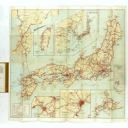
Travellers' Map of Japan, Chosen (Korea), Taiwan (Formosa) with Brief Descriptions of the Principal Tourist Points of Japan.
An early 20th century map which wss published in Tokyo for English speaking tourists.Very detailed set of maps of Japan and parts of Korea, Taiwan and part of China, show...
Date: Tokyo, 1925
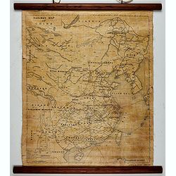
Railway map of China.
Railway map of China. Key in the left with keys to capital cities, Ocean cables, etc. Published by The Chinese Government Bureau of Economic Information, which was a nonp...
- $350 / ≈ €297
Date: China, ca. 1928
Carte du massif montagneux de Kuling (Province de Kiand-Si).
Manuscript map of the Kuling mountain range, showing the YangTze River, Lake Poyang, villages, etc. in French. Signed J.Volaz (?).Guling (or Kuling), is a resort town in ...
- $1500 / ≈ €1275
Date: China ?, ca.1930
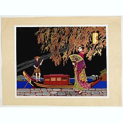
Art Deco gouache with Japanese scene.
Lovely art-deco gouache by Lucien Baubaut of an elaborately robed Japanese woman. The colors are simply stunning jewel-toned emerald, violet, deep purple, saffron and tan...
Date: Paris, ca. 1930

Carte routière de l'Indochine. Des kilomètres en sécurité sur Goodrich.
Advertising poster for the brand Goodrich, showing a map of Indochina.Goodrich Corporation is a former American company specializing in civil and military aeronautical eq...
Date: Paris, ca 1934

Philippines Islands.
Pictorial map of Philippines Islands, from the famous illustrator, Ruth Taylor White and published in "Our USA: A Gay Geography".Ruth Taylor White was among the...
Date: Boston, Little, Brown and Company, 1935

A Map and History of Peiping; formerly known as Peking; capital of provinces, princedoms and kingdoms since 1121 B.C. . .
The uncommon second edition of this very decorative and informative pictorial map of Beijing and surrounding areas whimsically illustrates the Forbidden City, essential e...
Date: The Peiyang Press, Ltd. Tientsin-Peiping, 1936

Outposts of Empire. Ceylon.
A large colored lithograph by John Vickery (1906-1983), he was an Australian artist. He worked in the fields of painting, illustration and advertising. He is the only Aus...
Date: London, ca 1937
l'Indochine Française
Map of Indochina published ca 1937 by Fernand Nathan, a well-known publisher of school books, maps and material for teaching geography.
Date: Paris, ca. 1937
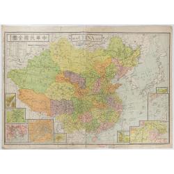
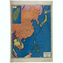
New China Map.
Very large and detailed map of China (1:6,000,000) printed in Shanghai, June 27th 1938 by JIN-SHIN GEOGRAPHICAL INSTITUTE.The title and place names in Chinese and Engli...
- $900 / ≈ €765
Date: Shanghai, June 27th 1938
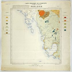
Carte géologique de l'Indochine à l'échelle du 1/500 000e. Pak-Nam Bang-Kok.
Map of Indochina Sheet N ° 16. Covers the area from Paknam (Thailand) to Kompong-Som Bay (Cambodia). On both sides a legend indicates the sedimentary and crystalline lan...
- $130 / ≈ €110
Date: Indo Chine, 1939
![Daily Telegraph War Map of The Far East. [No.11]](/uploads/cache/42244-250x250.jpg)
Daily Telegraph War Map of The Far East. [No.11]
A large and very detailed map of The Far East "Specially drawn for the Daily Telegraph by 'Geographia' Ltd". Printed in full color. Map extends from the norther...
- $125 / ≈ €106
Date: London, ca. 1940
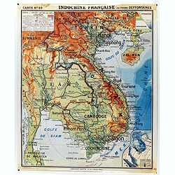
Indochine française. Carte N° 29.
School map of Indochina by Pierre Deffontaines Agréée d'Histoire et de Géographie Docteur es Lettres, published c. 1940 by "Librairie Hatier". Scale : 1:1 60...
Date: Paris, c. 1940
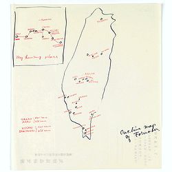
Map of Formosa. My hunting place.
An unusual hand drawn map of Formosa with an inset plan ‘My hunting place’. The map has the major cities marked in red ink and was made during Japanese occupation. Th...
Date: Chiayi, Formosa, ca. 1940
![Singapura em poder das Japoneses. [Singapore in Japanese Power]](/uploads/cache/48732-250x250.jpg)
Singapura em poder das Japoneses. [Singapore in Japanese Power]
An uncommon large Portuguese language and produced broadside celebrating the Japanese invasion of Singapore during WWII. It was published on behalf of the German Army Hig...
- $750 / ≈ €637
Date: Portugal, ca 1942

Ce que les Anglo-Saxons ont perdu en Extrême-Orient.
Illustrated Vichy propaganda War & Propaganda poster showing a map of South East Asia, with Indonesia, Philippines, Thailand, etc., among photos and explanations abou...
Date: Paris, 1943
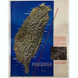
Formosa.
A large poster size map of the island of Formosa (Taiwan) off the Chinese mainland, prepared as a News Maps special edition during WWII. There is a red diagonal measureme...
- $750 / ≈ €637
Date: New York, 1943
![[Escape map] N°34 Southeast Asia + Northeast Asia.](/uploads/cache/40293-250x250.jpg)
[Escape map] N°34 Southeast Asia + Northeast Asia.
A fine "survival map" or "escape map" of China was compiled for the U.S. Army Air Forces. South China side has an inset of Taiwan (Formosa). These lig...
- $125 / ≈ €106
Date: Washington, D.C. 1944

China Southeast Coast.
A very large US Army and Naval map of the south east coast of China, published during the second world war. Map extent is from Kweichow Province in the west, to Kwangsi P...
- $1250 / ≈ €1062
Date: [New York], 1944

Singapore.
Chart of Southern part of Malaysian peninsular showing good detail on of Singapore. Map with legend and scale.
Date: London, 1944

Indie moet vrij vecht ervoor.
War propaganda poster by Patrick (Pat) Cokayne Keely, distributed in the liberated South of the Netherlands, this poster concerned the Japanese occupation of Indonesia an...
Date: London, J.Haworth / Brother Ltd, 1944
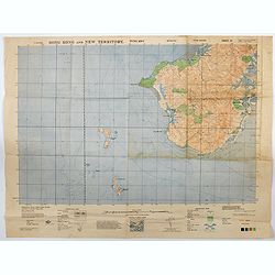
Hong Kong and New Territory - Tung Kwu.
A third edition air survey map of this portion of Lantau Island, to the west of Hong Kong, performed by the RAF. Originally published in 1931, then with minor corrections...
- $300 / ≈ €255
Date: London, 1945
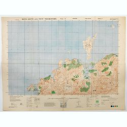
Hong Kong and New Territory - Tai O.
A third edition air survey map of this mainland portion of north west Hong Kong and New Territory, performed by the RAF. Originally published in 1931, then with minor cor...
- $400 / ≈ €340
Date: London, 1945

Kaart van Palestina voor oud- en nieuw testament behorend bij de weg met en naar Christus door Fr. M. Bellarminus.
Original vintage illustrated map wall map sized poster (166 x 118cm) of Palestine in the time of Christ featuring a map of the old and new testament of the Bible from The...
Date: Utrecht, Sint Gregoriushuis, 1948

Du sang à l'aube.
Original lithographed poster for the Spanish movie "Blood at dawn" (1948) directed by Rafael Gil, based on the novel by Blasco Ibanez. Poster designed by Duccio...
Date: Paris, 1948

Plan commercial de la Région Saïgon-Cholon.
Decorative publicity plan of Ho Chi Minh City, also known by its former name of Saigon and Cholon, prepared by Ngo-Trinh, surrounded by advertisements of local stores. Th...
Date: Saigon, 1948

Key Map of Hong Kong Relative to Canton and Macao.
A nice folded map of Hong Kong and the surrounding areas. Produced by the British Crown Lands Survey Office just after WWII. Physical features are shown by contour. Railw...
Date: Hong Kong, 1948
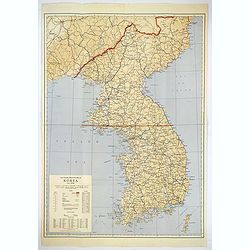
Official War map of Korea.
A large folding map of Korea published in the year of the outbreak of the Korean War, published by the Rand McNally Company. The map is extremely detailed and features a ...
Date: America, ca 1950
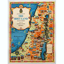
Ilustrated Map of The Holy Land for use in schools…
A visually striking and impressive pictorial map of The Holy Land, as issued by the National Savings Movement / Committee during the 1950s. In the upper left quadrant of...
- $250 / ≈ €212
Date: London, ca. 1950
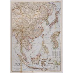
The Far East Compiled and Drawn in the Cartographic Section of the National Geographic Society for the National Geographic Magazine Gilbert Grosvenor. . .
Map of Far East Asia, with inset map of Korea. Scale 1:7.500.000. The first issue of National Geographic Magazine was published on September 22, 1888, nine months after t...
- $75 / ≈ €64
Date: Washington, 1952
Political Map of Asiatic Coastal Area.
A strongly colored, large map of the Asiatic Coastal countries. All countries are color coded. Maps coverage is from China and Japan in the north, south to the tips of Su...
- $450 / ≈ €382
Date: Chicago, ca 1952
Pacific Stars and Strips Map of the War.
A detailed map of the Korean War. Several silhouetted flying military aircraft are shown in formation. The map shows the Korean Peninsula from its northern border with Ru...
Date: America, 1953
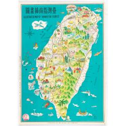
Illustrated map of Taiwan for tourist.
illustrated map of Taiwan for tourist. Pictorial map of Formosa published by Mei Kuang Art Company. Printed in English and Chinese. Features remarkable sites, various agr...
Date: Mei Kuang Art Company, 1954
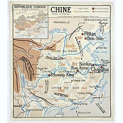
Chine - Angleterre.
A large, vintage French school poster map from the 1950s, showing China on one side and the United Kingdom on the reverse. As you would expect content and detail and basi...
Date: Nalliers, ca 1955

Indonesia.
Original vintage travel advertising issued by the Indonesian Council for Tourism featuring a colorful pictorial map marking the islands and oceans with images of local pe...
Date: Jakarta, ca. 1955
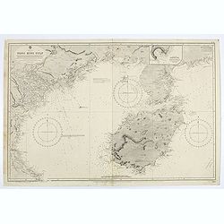
China sea. Tong King Gulf Compiled from the latest British and Foreign Government surveys to 1886. . .
Detailed Map of Chart of Annam Gulf or Tong King Gulf, in the China Sea. Chart with legend and scale. British Admiralty chart No. 2062, published June 1881, large correct...
- $400 / ≈ €340
Date: London, 1881 updated to 1957
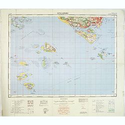
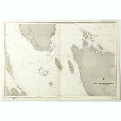
Singapore. - Sheet 134h Keppel harbour.
Map of Singapore. Map with legend and scale. According to a note "Prepared under the direction of the Surveyor General Malaya from the following sources materials : ...
- $750 / ≈ €637
Date: Kuala Lumpur, 1958

Festivals of India.
A large eye-catching poster of five women, dancing against a black background, dressed in stunning sari's of red, yellow and blue, produced in India by the Government, wi...
- $750 / ≈ €637
Date: Calcutta, 1959

Balinees watercolor on paper, fisherman.
Decorative export painting from Bali of a more than average quality.
- $150 / ≈ €127
Date: Bali, ca 1960

Balinees watercolor on paper, fishermen.
Decorative export painting from Bali of a more than average quality.
Date: Bali, ca 1960

Balinees watercolor on paper, fishermen.
Decorative export painting from Bali of a more than average quality.
- $150 / ≈ €127
Date: Bali, ca 1960
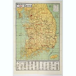
The Road Map of Southern Korea.
Offset printing. A large scale, comprehensive road map of South Korea, with a symbol legend and an inset map of 'The Republic of Korea', and inset of the island of Jeju D...
Date: Seoul, ca 1960
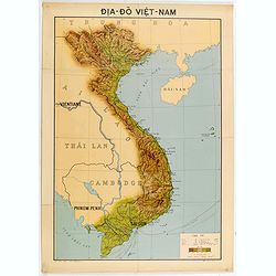
Dia-Do Viet-Nam.
Economic map of Vietnam published in 1960 (not for sale), gift from Japan paper committee. Scale : 1:2 400 000. With a key at lower right part.Features Vietnam, Cambodia,...
Date: 1960
![[US Army map of a part of Vietnam.]](/uploads/cache/44790-250x250.jpg)
[US Army map of a part of Vietnam.]
A large aerial US Army map of a portion of Vietnam, taken during the war between the two countries. As you might expect the map is highly detailed, highlighting settlemen...
- $150 / ≈ €127
Date: Washington D.C., 1967

Inde.
Decorative poster advertising flights to India made by Georges Mathieu. The poster is one of a series of 15 composed of posters of Greece, Israel, Germany, Great Britain,...
Date: Paris, 1967

Japan (poster signed by Georges Mathieu)
Dedicated "Pour Benijs Boulanger" and signed "Georges Mathieu", in black marker. Decorative poster advertising flights to Japan made by Georges Mathie...
Date: Paris, 1967

Israel.
Decorative poster advertising flights to Israel made by Georges Mathieu. The poster is one of a series of 15 posters of Greece, Israel, Germany, Great Britain, Canada, Eg...
Date: Paris, 1967
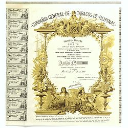
Compania General De Tabacos De Filipinas - (Certificate) Accion ordinarias de 500 Pesetas, Barcelona, 27.10.1969.
Beautifully engraved certificate from the Compania General De Tabacos De Filipinas issued in 1985. This historic document has an ornate border around it with a vignette o...
Date: Barcelona, 1969
![[Chinese propaganda poster]. We Shall Liberate Taiwan !](/uploads/cache/49024-250x250.jpg)
[Chinese propaganda poster]. We Shall Liberate Taiwan !
Chinese propaganda poster : "We Shall Liberate Taiwan!", by the Hongyingbi (Red Eagle Brush) unit of the Air Force Unit of Nanjing Military Region.The Chinese d...
Date: China, 1971
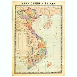
Hành Chính Việt Nam.
Uncommon map of Vietnam published in 1976, one year after the end of the Vietnam War. In April 1976, the National Assembly decided to reiterate Hanoi as the capital of th...
Date: Hanoï, 1976
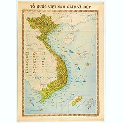
To Quoc Viet Nam Giau Va Dep (Vietnam).
Economic map of Vietnam published in 1976.Features Vietnam, Cambodia, Laos and part of Thailand. With a key referring to agricultural productions and fauna…The map show...
Date: Hanoï, 1976
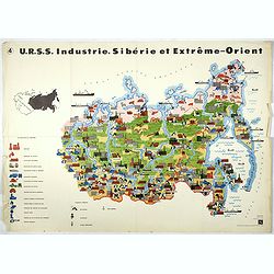
U.R.S.S. Industrie. Sibérie et Extreme-Orient. (4)
Map of Siberia. Propaganda poster for Russia's in and export of industrial goods from Siberia. Editions de l'Agence de presse Novosti".More about War Maps & Prop...
- $150 / ≈ €127
Date: USSR, 1978
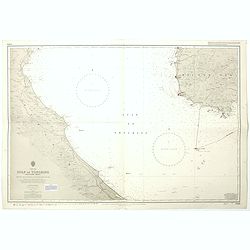
India west coast Gulf of Cutch to Vijaydurg . . .
Chart of India's west coast map surveyed by the hydrographer Captain JF Parry. A highly corrected version of Admiralty chart 2736 originally published 1st July 1915. Date...
- $200 / ≈ €170
Date: London, 1915-1980
![[Afghanistan].](/uploads/cache/44611-250x250.jpg)
[Afghanistan].
A scarce Russian relief map (in Russian) of Afghanistan published in Moscow during the Soviet occupation of the country during the early 1980s. Complete with a separate b...
Date: Moscow, 1982

Anamu Buru to Latakia including Iskenderun Körfezi.
A highly corrected version of Admiralty chart 2632 originally published 25 November 1955 under the Superintendence of Captain K.SB. Collins. Edition Date 1984 Detailed ch...
- $100 / ≈ €85
Date: London, 1955 - 1984
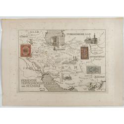
Persische Teppichknüpfgebiete und Stämme.
Map of Iran and neighboring countries in German language, published in limited edition probably in France : "Gravée à l'eau-forte et au burin. Edition limitée&quo...
Date: France ?, after 1935 - before 1991
China Sea Luzon Strait between Luzon and Tai-Wan from the United States & Japanese Government chartsto 1929. . . (3804)
A highly corrected version of Admiralty chart 3804 originally published 18 September 1925 under the Superintendence of Captain P.H. Douglas. New Editions 18th December 19...
- $150 / ≈ €127
Date: London, 1929 / 1992
China sea Gulf of Tongking (Southern sheet).
A highly corrected version of Admiralty chart 3989 originally published 11 Mai 1962 under the Superintendence of Captain EG Irving. Detailed chart including the coasts of...
- $80 / ≈ €68
Date: London, 1962 - 1992
China Sea Philippine Islands - San Bernandino Strait and approaches. (3370)
A highly corrected version of Admiralty chart 3370 originally published 14th November 1924 under the Superintendence of Captain H.P. Douglas. Edition Date 1982 with furth...
- $150 / ≈ €127
Date: London, 1924 / 1996

Philippine Islands - Semirara, Ilin and Ambulong 1.s with part of Mindoro. (971)
A highly corrected version of Admiralty chart 971 originally published 15th February 1866 under the Superintendence of Captain G.H. Richards. Edition Date 1991 with furth...
- $150 / ≈ €127
Date: London, 1866 / 1999

Philippine Islands - Mindanao West Coast - Basilan Strait to Camiguin Island including Tubbataha Reefs. . . (3811)
A highly corrected version of this oversized Admiralty chart 3811 originally published 26th February 1925 under the Superintendence of Captain P.H. Douglas. Edition Date ...
- $150 / ≈ €127
Date: London, 1925 / 2005

Carte géologique détaillée. Beyrouth.
Geological or soil map showing part of Lebanon with Beyrouth, including in top a colored legend with signs of the different geological ages. Provenance : Fondation P. Fal...
Date: Liban, Service geographique des F.F.L., 1945.

Carte géologique détaillée. Jezzîne.
Geological or soil map showing part of Lebanon with Jezzîne, including a legend with signs of the different geological ages and giving many information of greatest inter...
Date: Liban, Service geographique des F.F.L., 1945.

Carte géologique détaillée. Râchaïya Nord.
Geological or soil map showing part of Lebanon with Râchaïya , including a legend with signs of the different geological ages and giving many informations of greatest i...
Date: Liban, Service geographique des F.F.L., 1945.

Carte géologique détaillée. Zahle.
Geological map showing part of Lebanon with Zahle. , including a legend with signs of the different geological ages. Provenance : Fondation P. Fallot
Date: Liban, Service geographique des F.F.L., 1945.

Carte geologique detaillee. Jbail.
Geological or soil map showing part of Lebanon with Jbail antique Byblos Ancien Port phenicien / scale 1 : 50 000., including a legend with signs of the different geologi...
Date: Liban, Service geographique des F.F.L., 1945.