Browse Listings in America > South America

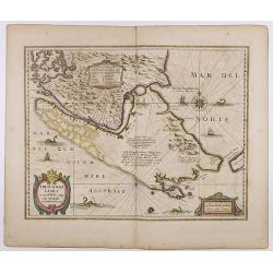
Il Cuscho citta principale della provincia del Peru.
A very desirable and scarce item of this decorative and early bird's-eye town-plan of the Inca city of Cuzco. Several figures shown inside the city walls and on the hills...
Date: Lyons, 1564

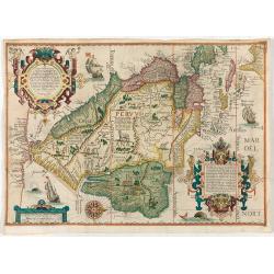
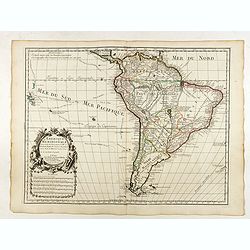
Americae Pars Magis Cognita. Chorographia nobilis & opulentae Peruanae Provinciae, atque Brasiliae, . . . MDXCII
First state. Although a map of South America it does include much of what is now the southern United States. There are two elaborate, strap-work cartouches with the one a...
Date: Frankfurt, 1592
(South America) - Delineatio omnium orarum totius Australis partis Americae, dictae Peruvianae, a R. de la Plata, Brasiliam Pariam, et Castellam auream una cum omnibus…
1593 LINSCHOTEN, J.H. van - Decorative map of South America, which goes as far north as part of Florida, is extremely well-detailed along the coast.
Date: Amsterdam, 1593

(Island of Pearls) Perlarum insula ob unionum copiam sic dicta.
A depiction of Cubagua as the Perlarum Insula (Island of Pearls), with in the foreground, two large ships send dinghies toward busy Native Americans collecting pearl oyst...
Date: Frankfurt, 1594
![[Navel battle between Portuguese and French Battle off Buttugar (Brazil).]](/uploads/cache/48526-250x250.jpg)
[Navel battle between Portuguese and French Battle off Buttugar (Brazil).]
Navel battle between Portuguese and French in the seas off the Poti guaran Territories in Brazil.Read more about "Les Grand Voyages" by Theodore De Bry [+]
Date: Frankfurt, 1594
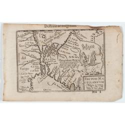
Fretum Magellanicum / Detroit de Magellan.
Early nice map of the South American extremity with the Strait of Magallanes, discovered by Ferdinand Magellan ( c. 1480 – 27 April 1521). Two natives holding a shield an...
Date: Amsterdam, 1606
Caarte vande nieuwe Passagie bezuijden de Strate Magellan. . . / Description de nouveau passage vers le zud du destroit de Maggellan. . .
Map showing the new route around the bottom of South America discovered by Schouten and Le Maire: through the Le Maire Strait, around the Barnevelt Islands, and past Cape...
Date: Frankfurt am Main, 1619
![Hanc Tabulam continens Laetam Pharnambuci.. . [Brazil].](/uploads/cache/16521-250x250.jpg)
Hanc Tabulam continens Laetam Pharnambuci.. . [Brazil].
An extremely rare and decorative map of coast-line of Pernambuco. With one inset: In the upper left corner a map of Brazil, with title in five lines Dutch and five lines ...
Date: Amsterdam, 1630
Sudseite des Landts Terza del Fuoco, abgezeichnet durch Iohan von Walbeck.
Map showing Cap Horn and the Terra del Fuego.From a German text edition of Theodor de Bry's travel book. The original copper plate is now shortened at the left side and h...
Date: Frankfurt am Main, 1630
Freti Magellanici ac novi Freti vulgo Le Maire. . .
A fine map of Tierra del Fuego. With an explanatory text of the passage by Barent Jansz. Potgieter, who accompanied Captain Sebald de Weert to the Straits in 1599/1600, w...
Date: Amsterdam, ca. 1633
![[The Dutch covalesce on the Isle Santa Clara.]](/uploads/cache/40359-250x250.jpg)
[The Dutch covalesce on the Isle Santa Clara.]
Fanciful map of the Island of Santa Clara (Isla Do Francez), as seen by the Dutch in 1599, during the exploration of Olivier de Noort, published by Theodore de Bry, one y...
Date: Frankfurt, M.Merian, 1633
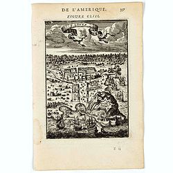
![[Incas lay siege to Cusco.]](/uploads/cache/40353-250x250.jpg)
[Incas lay siege to Cusco.]
Atahualpa’s brother, Manco, organized a long and bloody siege to reoccupy the Inca capital, which eventually spread to open rebellion throughout the land. Pizarro, who by...
Date: Frankfurt, M.Merian, 1633
Selling price: ????
Please login to see price!
Sold in 2025

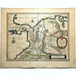
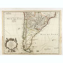
Paraguay o Prov. de Rio de la Plata cum regionibus adiacentibus Tucuman et Sta. Cruz de la Sierra.
Blaeu's map of the Rio de la Plata region of South America. Originally engraved for Jodocus Hondius II, at his death in August 1629 this map was, among 39 other copper pl...
Date: Amsterdam, 1634
Terra Firma et Novum Regnum Granatense et Popayan.
A handsome map of modern-day Panama and Colombia. The cartouches and decoration are colored in an artistic way. Very fine and rare with this type of coloring.From "l...
Date: Amsterdam, 1635-1638
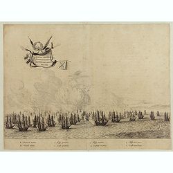
Quartum Praelium Coniovian inter et Fluvium Rio Grande XVII Ian
Decorative engraving of the fourth sea battle with the Portuguese fleet offshore at the Rio Grande, in1640. Engraved by J. van Brosterhuyzen after a design by Frans J. Po...
Date: Joannes Blaeu, Amsterdam 1647

Rerum per octennium in Brasilia Et alibi nuper gestarum, Sub Praefectura Illustrissimi Comitis I. Mauritii, Nassoviae, (...) Historia.
First edition. Commissioned by Johan Maurits van Nassau (governor of Brazil between 1636-1644 and founder of "Mauritsstad" (present-day Recife)) and illustrated...
Date: Amsterdam, J. Blaeu, 1647
La Guaiane ou Coste Sauvage, autrement El Dorado, et Pais des Amazones…
An extremely rare edition of Du Val's map, separately published by Jollain in 1668, that references the name "El Dorado" in its title. The title translates as f...
Date: Paros, Chez Jollain, 1668

Brasila.
Map of Brazil extending from C. Nasou and Parime Lago to the Mouth of the Rio de la Plata. Oriented with West on top.The cartography of the region is quite primitive. The...
Date: Amsterdam, 1673
F. Louys.
A charming bird's-eye view of Fort St Louis at Cayenne. Title in curtain draped at top. French text on verso.The fort is located on Mont Cépérou, with a panoramic view o...
Date: Paris, 1683
L'Amerique Meridionale Dressée sur les Observations de Mrs de l'Academie Royale des Sciences . . .
Rare state of " L’Amerique Meridionale. Chez l’Auteur sur le Quai de l’Horloge a la Courone de Diamans avec Privilege du Roy pour 20 ans, 1700".Fine map of Sout...
Date: Paris, 1700
Carte du Paraguay du Chili.
A finely engraved, detailed map of the southern half of South America. Prepared by de l'Isle with the imprint "Chez l’Auteur sur le Quai de l’Horloge avec Privilege ...
Date: Paris, L. Renard, 1703
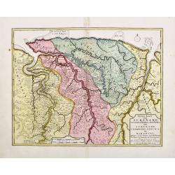
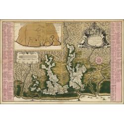
Nieuwe kaart van Suriname vertonende de stromen en land-streken van Suriname, Comowini, Cottica en Marawini, gelegen in Zuid America op de kusten van Caribana. . .
Decorative full color example of Ottens' map of Suriname. Detailed map of the northeast part of Suriname between Paramaribo, with fort Zeelandia, and Mana.Along the Surin...
Date: Amsterdam, ca. 1713-1718

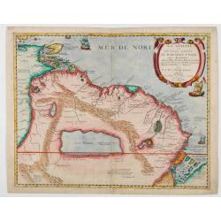
Tabula Americae Specialis Geographica Regni Peru, Brasiliae, Terra Firmae & Reg: Amazonum, Secundum relationes de Herrera, de Laet & PP d Acuña & M. Rodriguez . . .
A good and clean copy of Homann's map of the northern part of South America. The map is on the Valley of the Amazon and delineates the Amazon and its labyrinth of tributa...
Date: Nuremberg, 1728
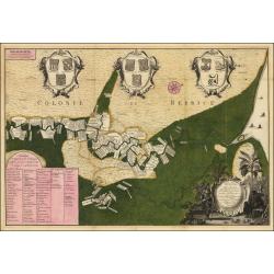
Naaukeurige Platte Grond van den Staat en den Loop van Rio de Berbice Met derzelver Plantagien in de Geoctrojeerde Colonie de Berbice Gelegen. . .
Uncommon large-scale map of Berbice with Rio de Berbice and Rio de Canje, with at the bottom left a list of plantation owners. In the top 3 x 3 coats of arms in cartouche...
Date: Amsterdam, 1740
Algemeene kaart van de Colonie of Provintie van Suriname : met de rivieren, districten, ontdekkingen door militaire togten. . .
1740 DE LETH, H. - Large-scale map of Suriname, a record of one of the most important early Jewish communities in the Americas.
Date: Amsterdam, 1740

Paraquariae Provinciae Soc. Iesu cum Adjacentibus Novissima...
Between the years of 1609 and 1780, the Jesuits (the Roman Catholic Society of Jesus) established in South America, an autonomous Christian state, on the lands of present...
Date: Augsburg, 1740

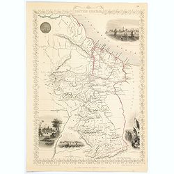
Typus Geographicus Chili Paraguay Freti Magellanici &c.
Detailed map covering the southern part of the continent based on the cartography of Delisle and the information gleaned from the voyages of Brouwer, Narbouroug and Beauc...
Date: Nuremberg, 1750
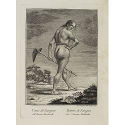
Uomo del Paraguai nell' America Meridionalle. / Homme du Paraguai dans l'Amerique Meridionalle.
Full portrait of a person from Paraguay. From "Raccolta di stampe." a series of historically significant eighteenth-century copper plate engravings by Venetian...
Date: Venice, Antonio Zatta, c.1790

Indiana del Perù. / Indienne du Perou.
Portrait of a Peruvian Indian woman holding a fruit basket and a lama in the background. From "Raccolta di stampe." a series of historically significant eighte...
Date: Venice, Antonio Zatta, c.1790

Géographie des Plantes Equinoxiales - Tableau physique des Andes et pays voisins. . .
Physical Portrait of the Andes and adjacent lands", organized around the Chimborazo and Cotopaxi volcanoes in Ecuador.With local vegetation is illustrated pictoriall...
Date: Paris, 1805

Paraguay, Chili, Terre Magellan ?
Map of Paraguay, Chili, and Argentina . By C. F. Delamarche, successor of Robert de Vaugondy, Geographer.
Date: Paris, 1794 -1806
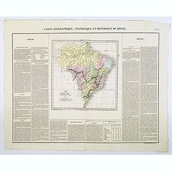
Carte Geographique, Statistique et Historique du Bresil.
A nice detailed map of Brazil from Buchon's Atlas Gégraphique Statistique, historique et chronologique des deux Ameriques et des isles adjacentes traduit de l'atlas exécu...
Date: Paris, 1825
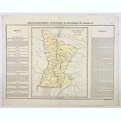
Carte Geographique, Statistique et Historique du Paraguay.
A nice detailed map of Paraguay from Buchon's Atlas Gégraphique Statistique, historique et chronologique des deux Ameriques et des isles adjacentes traduit de l'atlas exé...
Date: Paris, 1825

Carte Geographique, Statistique et Historique de Buenos-Ayres.
A nice detailed map of what is today northern Argentina (Rep. of Buenos Ayres or the United Provinces of South America) from Buchon's Atlas Gégraphique Statistique, histo...
Date: Paris, 1825

Carte Geographique, Statistique et Historique du Perou.
A nice detailed map of Peru from Buchon's Atlas Gégraphique Statistique, historique et chronologique des deux Ameriques et des isles adjacentes traduit de l'atlas exécuté...
Date: Paris, 1825

Carte Geographique, Statistique et Historique de l'Amerique Meridionale.
A nice detailed map of South America from Buchon's Atlas Gégraphique Statistique, historique et chronologique des deux Ameriques et des isles adjacentes traduit de l'atla...
Date: Paris, 1825

Rivage du port Saint-Nicolas.
Exquisite contemporary colored lithograph of Port Saint-Nicolmas Bay in most southern part of South America, with Dumont D'Urville's officers making landfall. Drawn by E....
Date: Paris, 1846

Entrée des forêts de la rivière Sedger. . .
Exquisite contemporary colored lithograph of Sedger's river in the Chili, with as seen by Dumont D'Urville's, with Indians. Drawn by Louis Le Breton, lithographed by Bich...
Date: Paris, 1846
British Guayana.
A decorative steel engraved map of British Guyana. The last Tallis map of the region, published circa 1858 by The London Printing and Publishing Company (the partnership ...
Date: London, 1858

Mapa geogra´fico de la mayor parte de la Ame´rica Meridional que contiene los paises por donde debe trazarse la li´nia divisoria que divida los dominios de Espan~a y Portugal. . .
Rare first edition of the map drawn by Francisco Requena (1743-1824) after his expedition to the Amazon in order to delineate the boundary between the Spanish and Portugu...
Date: Bourquin, F. Philadelphia, ca. 1876

Nuevo plano de la ciudad de Buenos Aires y parte del partido de avellaneda . . .
A rare detailed city plan of Buenos Aires prepared in 1912 by Ernesto Escalante. The plan depicts the city from the Partido de Avellaneda and the Villa Riachuelo to the R...
Date: Buenos Aires, 1912
![Mapa geral do Brasil / organizado pelos J. Carneiro da Silva e Pedro Voss. [Together with] Micro geografia do Brasil. [Together with] Pequeno Mapa do Brasil.](/uploads/cache/45466-250x250.jpg)
Mapa geral do Brasil / organizado pelos J. Carneiro da Silva e Pedro Voss. [Together with] Micro geografia do Brasil. [Together with] Pequeno Mapa do Brasil.
Large folding national map published by "Comp. Melhoramentos de São Paulo Industrias de Papel". Nova edicao revista 1946. Figures for all states. "Futuro D...
Date: São Paulo, 1946
