Browse Listings

1) Le Kakatoës à Huppe Jaune. 2) Le Lori Tricolor. Le Perroquet Vert.
Noteworthy bird print from 1839 Furne edition of the Histoire naturelle, générale et particulière by Georges-Louis Leclerc, Comte de Buffon.Engraved by Fournier after ...
Date: Paris, 1838 - 1839
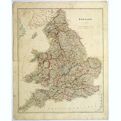
England.
A large and detailed steel-engraved map of England, with each county divided by a different color. Many place names and physical features are shown, illustrating how dens...
Date: London, 1839
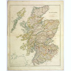
Scotland.
An attractive steel engraved map of Scotland, with each county divided by a different color. Many place names and physical features shown.The Arrowsmith family members we...
Date: London, 1839
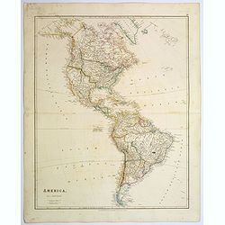
America.
A beautiful, large-scale map of the Americas. Alaska is named as 'Russian America', Texas is still a part of Mexico, yet to become a republic (1836), before finally becom...
Date: London, 1839
Selling price: ????
Please login to see price!
Sold in 2025

Upper Canada &c.
A beautiful, large scale map of Upper Canada, and portions of the American states of New York, Ohio, and Pennsylvania. The province of 'Upper' Canada was created by the B...
Date: London, 1839
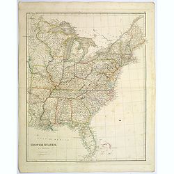
United States.
A lovely large map of the Untied States, as it was at the time of publication. Each state shown in a different outline color. Nothing is shown west of Louisiana, Arkansas...
Date: London, 1839
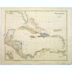
West Indies.
A fine, detailed steel engraved map comprising Florida, Bahamas, Cuba, Haiti, Jamaica, the Windward, and the Leeward Islands, the northern Columbian coastline, Panama, Gu...
Date: London, 1839
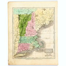
Eastern States.
A map of the eastern US seaboard from Long Island north to Lower Canada, comprising the states of Connecticut, Rhode Island, Massachusetts, New Hampshire, Maine, Vermont ...
Date: Connecticut, 1839

La parte orientale dell' antico.. messico con la Florida..
A splendid two-sheet map of Mexico, including California, Arizona, New Mexico, part of Texas, Baja California and Mexico (west part) and of the Southeast Part of the US, ...
Date: Rome, Calcography, 1797-before 1839
Oostindische Zeemagazijn. & De Werf van Het Oostind. Zeemagazijn.
Two decorative lithographies on one sheet, illustrating the V.O.C. East Indian Arsenal and the naval shipyard.
Date: Amsterdam, ca. 1840
!['S Lands Magazijn en Werf. [&] Het Oostindischehuis.](/uploads/cache/22713-250x250.jpg)
'S Lands Magazijn en Werf. [&] Het Oostindischehuis.
Two decorative lithographies on one sheet. View of the 'T Landts Magazyn , or 'Scheepvaartsmuseum' (Maritime Museum) on top. On the bottom the East Indian House , the hea...
Date: The Hague, 1840
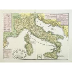
L'Italia antica-romana.
A rare and detailed double-page map of ancient Italy. According to the title cartouche, prepared by A de La Sage for l'Atlante Storico, Letterario, Biografico, Archeologi...
Date: Venice, 1840

Wallis's Guide for Strangers Through London.
Engraved plan with original hand-coloring, with title and alphabetical list of the principal streets below. Published by Edward Wellis 42 Skinner Street.With "An alp...
Date: London, E.Wallis, ca. 1840

Vue de la ville et du château de Heidelberg . . . Ansicht der stadt und des schlosses Heidelberger . . .
Engraving after Louis Charles François de Graimberg-Belleau. Engraved by Ch. Haldennvang.French artist. Son of Gilles-François Belleau Graimberg. Louis Charles Françoi...
Date: Graimberg, Heidelberg, ca. 1840
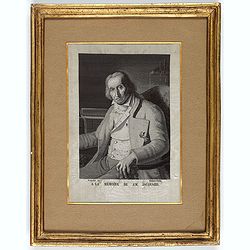
(Portrait of Joseph-Marie Jacquard).
A rare woven silk portrait of Joseph-Marie Jacquard after Bonnefonds, completed on the Jacquard punched-card loom. Woven by Carquillat in the silk factory of Didier Petit...
Date: France, ca. 1840
![Actualites. [News]](/uploads/cache/46547-250x250.jpg)
Actualites. [News]
A lithographic cartoon showing two tradesmen conversing. One says to the other: "Eh! Well jocker you're not working anymore!" "I have colic!" says the...
Date: Paris, ca 1840
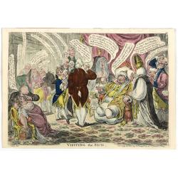
Visiting The Sick. (319).
Caricature by J. Gillray. Charles James Fox, dangerously ill, visited by an entourage of interesting factions: representing the social and ministerial conflict surroundin...
Date: Henry G. Bohn, London, 1840
Selling price: ????
Please login to see price!
Sold in 2025

Arabia. Sive Regio inter Mare Medium, Arabicum Sinum, . . .
Very detailed map of the Arabian Peninsular, covering the Caspian Sea in the upper right corner and Syria to the Indian Ocean, Somalia and parts of Persia, Syria and Kurd...
Date: London, 1841
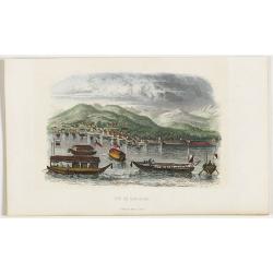
Vue de Nangasaki
View over the town from the water, identifying clearly Deshima with Japanese sloops in the fore ground. Engraved by Alp.Boilly.
Date: Paris, 1842

Kaart van de Gaspar Straaten volgens opnemingen van J.Stolze, D.Ross, enz.
Very large and rare chart centered on the strait between Bangka's southeastern seacoast and Belitung's western shores.Short front views of the coastal relief are shown in...
Date: Amsterdam 1843

Straat Riouw onder opzicht van de commissie tot verbetering der Indische Zeekaarten..
Very large and rare so-called Blue Back centered on the strait passing between the Riau Islands. It contains an inset map with enlarged details of Riouw Harbor on Bintang...
Date: Amsterdam 1843
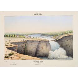
Southern - Concan.. - The falls of Gokank..
Hand colored lithography representing a view of the Gokak Falls, located on the Ghataprabha River. The Ghataprabha river in India is an important right-bank tributary of ...
Date: Paris, 1843
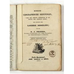
Korte geographische oefeningen voor het eerste onderwijs in de kennis der geheele aarde
Ilustrated with World Map, map of Europe, the Netherlands, Asia, Africa, North America, South America and Australia.Provenance : J.de Veth, October 1845.
Date: Zaltbommel, 1843

Kaart van een gedeelte van de Noord Kust van Java en Straat Sunda van Tanjong Kaik tot den vierden hoek bij Anjer..
Very large and rare chart depicting Java's northern seacoast.Coastal profiles are present at the bottom of the map.The chart is prepared by B.H.Staring, J.A.G.Rietveld an...
Date: Amsterdam 1843-1844
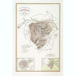
Divisione Militare di Alessandria. Provincie di Casale e di Asti.
"Published in ""Atlante Geografico dell' Italia"". With inset cartouche with detailed plans of the cities of Asti and Casale. Showing the river P...
Date: Florence, 1845
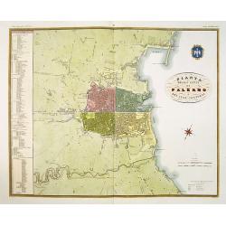
Pianta della citta di Palermo e dei suoi contorni.
Published in Atlante Geografico dell' Italia . Uncommon and decorative town-plan of Palermo. With a numbered key.Engraved by P. Manzoni.
Date: Florence, 1845
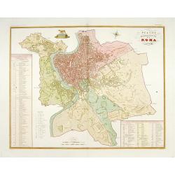
Pianta della citta di Roma.
Published in "Atlante Geografico dell' Italia". Uncommon and decorative town-plan of Rome. With a numbered key. Engraved by P.Manzoni.
Date: Florence, 1845

Optique de St.Cloud.
This perspective view of St. Cloud comprises 6 hand colored images of the grand Bassin d'Apollon viewed through an square and two round holes cut out from the front card ...
Date: Paris, ca.1845
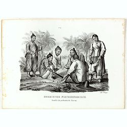
Koreische Fischerfamilie. Famille de pecheurs de Corea.
A Korean family of fishermen playing a board game. No.9' above image. From "Schinz Naturgeschichte und Abbildungen des Menschen der verschiedenen Rassen und Stämme&...
Date: Zürich, 1845
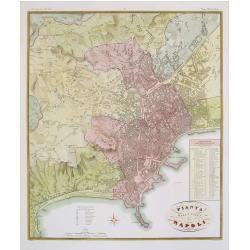
Pianta della citta di Napoli.
Published in Atlante Geografico dell' Italia. Uncommon and decorative town-plan of Naples. With a numbered key.Engraved by P.Manzoni.
Date: Florence, 1845

Het Klooster ten Hage (Marienhage Eindhoven)
Very rare lithography of the ruin of the monastery of Ten Haghe in Eindhoven. Lithographed by M.Mouret, published in "oud-Nederland en de uit vroegere dagen overgebl...
Date: Nijmegen, 1837-1846

Straat Sunda en Westkust van Java.
Very large and rare chart depicting Java's western seacoast close to the Sunda Strait.Showing part of Sumatra on top and the West Java tip, today hosting the Ujung Kulon ...
Date: Amsterdam (1841)1846

Entrée des forêts de la rivière Sedger. . .
Exquisite contemporary colored lithograph of Sedger's river in the Chili, with as seen by Dumont D'Urville's, with Indians. Drawn by Louis Le Breton, lithographed by Bich...
Date: Paris, 1846

Rivage du port Saint-Nicolas.
Exquisite contemporary colored lithograph of Port Saint-Nicolmas Bay in most southern part of South America, with Dumont D'Urville's officers making landfall. Drawn by E....
Date: Paris, 1846

Kaart van de Reede van Batavia met de verschillende vaarwaters naar dezelve trigometrisch opgenomen op last van deb schout bijnacht E.Lucas.
Very large and rare so-called blue-black chart centered on Jakarta's harbor.The chart is prepared by B.G.Escher, I.A.C. Eschauzier, B.H.Staring and E.H.Boom during an exp...
Date: Amsterdam (1841) 1847

Kaart der Moluksche eilanden en vaarwateren … F.A.A. Gregory Luitenant ter zee …
Huge sailing chart centered on the Moluccas Islands. Published by Widow Gerard Hulst van Keulen.The publishing house van Keulen, were the most prominent chart makers at ...
Date: Amsterdam, 1847
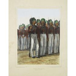
Infanterie Turque (chasseurs). 7 novembre 1837.
Beautiful lithography by Auguste Raffet (1804 -1860 ) and printed by Auguste Bry.
Date: Paris, Gihaut frères, 1848
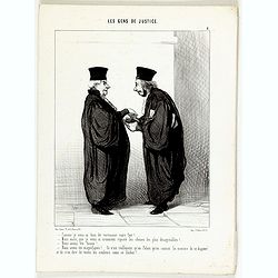
Les Gens de Justice. - Comme je vous ai bien dit vertement votre fait !
Second state (of 2), with text. From "Les Gens de Justice". Text below image : - Comme je vous ai bien dit vertement votre fait !. . . - Mais aussi, que je vous...
Date: Paris, 1845-1848
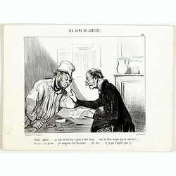
Les Gens de Justice. - Plaidez, plaidez . . . ça sera un bon tour à jouer à votre voisin. . .
Second state (of 2), with text. From "Les Gens de Justice". Text below image : - Plaidez, plaidez . . . ça sera un bon tour à jouer à votre voisin . . . vous...
Date: Paris, 1845-1848
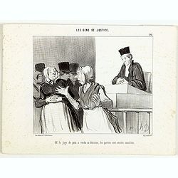
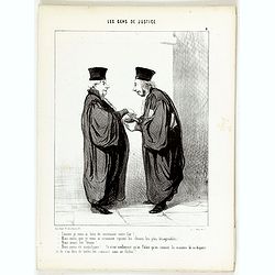
Les Gens de Justice. - Mr. le juge de paix a rendu sa décision, le sparties sont censées conciliées.
Second state (of 2), with text. From "Les Gens de Justice". Text below image : - Mr. le juge de paix a rendu sa décision, le sparties sont censées conciliées...
Date: Paris, 1845-1848

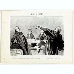
Les Gens de Justice. - Mr. l'avocat a rendu pleine justice au rare talent déployé par le ministère public . . .
Second state (of 2), with text. From "Les Gens de Justice". Text below image : - Mr. l'avocat a rendu pleine justice au rare talent déployé par le ministère ...
Date: Paris, 1845-1848
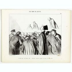
Les Gens de Justice. - L'avocat qui se trouve mal - dernière ressource quand la cause est bien malade.
Second state (of 2), with text. From "Les Gens de Justice". Text below image : - L'avocat qui se trouve mal - dernière ressource quand la cause est bien malade...
Date: Paris, 1845-1848
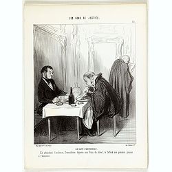
Les Gens de Justice. - Au café d'Aguesseau.
Second state (of 2), with text. From "Les Gens de Justice". Text below image : - Au café d'Aguesseau. En attendant l'audience, Démosthéne déjeune aux frais ...
Date: Paris, 1845-1848
Les Gens de Justice. - Un avocat qui éviemment est rempli de la conviction la plus intime . . .
Second state (of 2), with text. From "Les Gens de Justice". Text below image : - Un avocat qui éviemment est rempli de la conviction la plus intime . . . que s...
Date: Paris, 1845-1848
Les Gens de Justice. - Comme je vous ai bien dit vertement votre fait! . . .
Second state (of 2), with text. From "Les Gens de Justice". Text below image : - Comme je vous ai bien dit vertement votre fait! . . . - Mais aussi, je vous ai...
Date: Paris, 1845-1848

ARMENIEN. Costumes de l'Empire Ottoman 9.
A beautiful hand colored lithograph of an Armenian published in the French work "Galerie Royale de Costumes peints d´après nature par divers artistes et lithograph...
Date: Paris, Chez Aubert & Cie., 1842-1848
AFGHAN de CABOULE. Costumes Persans 8.
A beautiful hand colored lithograph of an elegant Afghan from Kabul published in the French work "Galerie Royale de Costumes peints d´après nature par divers artis...
Date: Paris, Chez Aubert & Cie., 1842-1848

DANSEUSE. Costumes Persans 9.
A beautiful hand colored lithograph of an elegant dancing girl from Persia published in the French work "Galerie Royale de Costumes peints d´après nature par diver...
Date: Paris, Chez Aubert & Cie., 1842-1848
Carte des Détroits Singapore, Durain..
An exceptionally rare nautical chart of Singapore and direct vicinity issued by Urban Dortet de Tessan, under the patronage of Louis Philippe I of France. When Singapore...
Date: Paris, 1848

20 small lithographed views of Washington DC and Georgetown.
20 small lithographed town-views of Washington DC and Georgetown, cut out from a larger sheet. Showing the East Front of the Capitol, Treasury, Smithsonian Institute, Pre...
Date: Casimir Bohn, Washington, D.C.: 1849

Océanie.
A very decorative 19th century map of the Pacific Ocean, with hand colored lines indicating the extent of Polynesia, Mirconesia, Melanesia, and Malaysia (or Southeast Asi...
Date: Paris, 1850
Selling price: ????
Please login to see price!
Sold in 2025

Océanie.
A very decorative 19th century map of the Pacific Ocean, with hand colored lines indicating the extent of Polynesia, Micronesia, Melanesia, and Malaysia (or Southeast Asi...
Date: Paris, 1850

Saint Petersbourg. Maison de bienfaisance, appartenant à Mr Anatole de Demidoff. . .
Beautiful lithography showing the house of Anatole de Demidoff in Saint Petersburg.
Date: Paris, c. 1850

Nice Vue prise audessus de Montalban.
Beautiful view of Nice from the book "l'Italie à vol d'oiseau".
Date: Paris, 1850
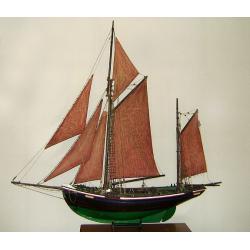
MAUREEN Shipping model of a fishing boat.
This type of fishing ships were used by the Dutch fisherman to fish for codfish, and even reached with them into the Canadian waters.Overall dimensions: 1400 x 100 x 230m...
Date: Netherlands, ca. 1850
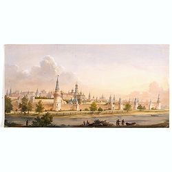
(View of the Moscow Kremlin, seen from the Moskva River in the south).
Anonymous, likely Russian School gouache drawing of Moscow Kremlin. The Kremlin is depicted in a typical 19th century romantic style and is seen from the Moskva river in ...
Date: Russia, ca. 1850
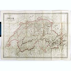
Carte de la Suisse . . .
Detailed canvas map of Switzerland.
Date: Paris, 1850
![Aux grands maux les grands remedes. [To great ills great remedies]](/uploads/cache/46558-250x250.jpg)
Aux grands maux les grands remedes. [To great ills great remedies]
A humorous French lithograph showing a village scene where a small infant is held face down on his/her mother's lap, with clothing pulled up to reveal its bottom. An enor...
Date: Paris, ca 1850
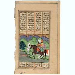
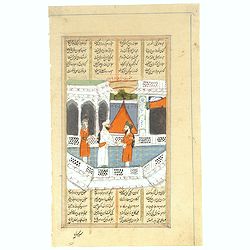
Persian miniature paintings, Mogul Dynasty.
Indo/Persian, Mogul Dynasty miniature painting in delicate Opaque watercolors on paper, with Islamic scripts on recto and verso. Miniature about 135 x 150mm. Painted in g...
Date: Northern Indian Mogul dynasty, ca 1800-1850
Persian miniature paintings, Mogul Dynasty.
Indo/Persian, Mogul Dynasty miniature painting in delicate Opaque watercolors on paper, with Islamic scripts on recto and verso. Miniature about 70 x 150mm. Painted in gi...
Date: Northern Indian Mogul dynasty, ca 1800-1850
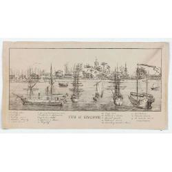
View of Singapore
Very rare view of Singapore from the Singapore River Basin. With a numbered key (1-19) underneath the illustration. In the center Government Hill with Governer's House (1...
Date: ca. 1850
![Posesiones de America : Isla de Cuba. [together with] Isla de Cuba. . .](/uploads/cache/23458-250x250.jpg)
Posesiones de America : Isla de Cuba. [together with] Isla de Cuba. . .
Wall size sea chart and map of land areas showing all of Cuba, part of Florida Keys plus San Adios and Salvador Grande in the Bahamas.Minute topographical, political, and...
Date: Madrid, 1853 / 1851

Plan de Constantinople, non compris ses faubourgs. Grave d'apres les documents du ministere de la Guerre par E. Olivier.
A very rare lithographic large-scale town-plan of Istanbul, Scale 98 yards to one inch., printed in Pera, Istanbul by E. Olivier. The ornate design on the top of the...
Date: Péra, Istanbul, 1851
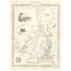
Part of South Australia.
Decorative steel engraved map of part of South Australia, surrounded by illustrations of Adelaide, natives on a catamaran, an Australian dog and a nymphicus bird illustra...
Date: London, ca. 1851
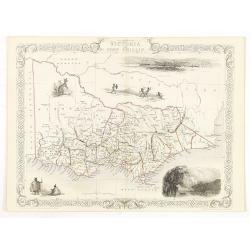
Victoria or Port Phillip.
Decorative steel engraved map of Victoria or Port Phillip, surrounded by illustrations of Melbourne, indigenous people and the Glenelg River. Interlocking border design. ...
Date: London, ca. 1851

Australia.
Decorative steel engraved map of Australia, surrounded by illustrations of Sydney harbor, birds, kangaroos and local people. Interlocking border design. Taken from "...
Date: London, ca. 1851
Western Australia. Swan River.
Decorative steel engraved map of part of Western Australia and Swan River, surrounded by illustrations of Perth, Aborigines and sheep shearing. With the seal of Western A...
Date: London, ca. 1851
Islands in the Atlantic.
Decorative steel engraved map of Islands showing the Azores, Madeira, Bermuda, the Canaries and the Cape Verdes. Interlocking border design. Taken from "The illustra...
Date: London, ca. 1851
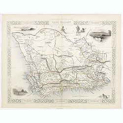
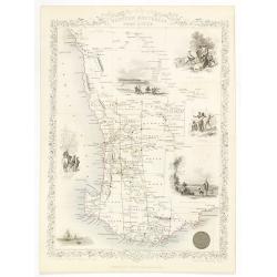
Cape Colony.
A decorative steel engraved map from the famous Victorian publisher John Tallis and Company, published ca.1851. Drawn and engraved by J Rapkin, while the four corner vign...
Date: London, Edinburgh, Dublin, 1851

Simori.
Portrait of Simori.Von Siebold was born in Wurtzburg, in Germany, and worked for the Dutch government as a doctor in Java. In Japan, where Von Siebold arrived in 1823 at ...
Date: Leiden, 1832-1852
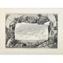
![Dépt. De L'Aude. N°10. [ Carcassonne ]](/uploads/cache/27089-250x250.jpg)
Dépt. De L'Aude. N°10. [ Carcassonne ]
Map of the Aude region, centered on the town of Carcassonne. Reaching to the right till the Mediterranean.Lovely map from one of the last decorative atlases of the ninete...
Date: Paris, A. Combette, 1852
Algérie, Colonie Française. N°87.
Map of Algeria.Lovely map from one of the last decorative atlases of the nineteenth century.The rather simple map is framed by medallion portraits and coats of arms, and ...
Date: Paris, A. Combette, 1852
ABIETUM phyllulae et pulvini.s. Tab. 137.
From his famous work 'Flora Japonica'. Von Siebold was born in Würzburg, Germany, and worked for the Dutch government as a physician in Java. In Japan, where Von Siebold...
Date: Leiden, 1852
La Corvette la recherche au milieu des glaces.
Beautiful lithograph by A. Mayer and Bayot of the corvette "La recherche" surrounded by Ice. Published by Arthus-Bertrand and Lemercier in Paris.From Joseph Pau...
Date: Paris. Arthus-Bertrand, 1838-1852

(The City And Harbour Of Sydney From Near Vaucluse.)
One of the most sought after views of the city and harbour of Sydney seen from Near Vaucluse, 1852. Magnificent hand-colored tinted lithograph and finished by gum-Arabic....
Date: London, J. Hogarth, 1852

Map of the Great Salt Lake And Adjacent Country in the Territory Of Utah. Surveyed in 1849 and 1850, under the orders of Col. J.J. Abert ...
Map of the Great Salt Lake And Adjacent Country in the Territory Of Utah. Surveyed in 1849 and 1850, under the orders of Col. J.J. Abert .. by Capt. Howard Stansbury .. a...
Date: Ackerman, New York, 1852
![[Collection of six maps of Australia and New Zealand.]](/uploads/cache/48412-250x250.jpg)
[Collection of six maps of Australia and New Zealand.]
Collection of maps including 6 engraved maps by 19th century German, French and English cartographers depicting Australia and New Zealand.This made to order atlas contain...
Date: Germany, 1832-1852
![ISLA DE CUBA [with 2 maps] Plano Pintoresco De La Habana con los numeros de las casas B. May y Ca. 1853. (with) Inset map Puerto y Cereanias De La Habana. (with) 14 views of Havana & prominent buildings.](/uploads/cache/36720-250x250.jpg)
ISLA DE CUBA [with 2 maps] Plano Pintoresco De La Habana con los numeros de las casas B. May y Ca. 1853. (with) Inset map Puerto y Cereanias De La Habana. (with) 14 views of Havana & prominent buildings.
Lithographic town-plan surrounded with views of the city of Havana including the "Fuente De La India En El Paseo De Isabel 2a." and "Vista Gral De La Haban...
Date: Havana, 1853
![Le Sacre Hagard [Haggard-falcon]](/uploads/cache/44315-250x250.jpg)
Le Sacre Hagard [Haggard-falcon]
A beautiful elephant folio sized colored lithograph of a Hagard Falcon, taken from the famous book on Falconry Traite de Fauconnerie by Schlegel and A.H. Verster van Wulv...
Date: Leiden, 1844-1853

The town & harbour of Sevastopol with the batteries & approaches. . .
Rare colored linen backed map showing the harbour and town of Sevastopol, with soundings. In upper left corner a inset map (65x150mm) of the Black Sea. In bottom part a l...
Date: London, March 27th, 1854
