Browse Listings
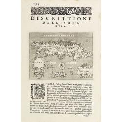
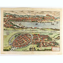
Descrittione dell'Isola Cuba.
Early map of Cuba, published in Venetia, Appresso gli Heredi di Simon Galignani, 1590.
Date: Venise 1590
Selling price: ????
Please login to see price!
Sold
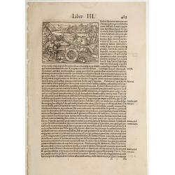
Canons.
On recto an early representation of a siege of a town with canons: To the right a presentation of the devil with a monk. (Print : 70x96 mm). With the initial DK David Kan...
Date: Basle, 1550-1590
Selling price: ????
Please login to see price!
Sold in 2011
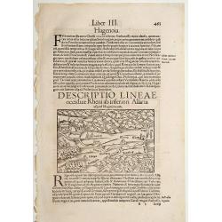
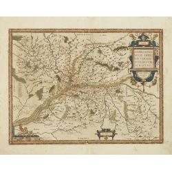
Descriptio Lineae Occiduae Rheni .. / Alsatia.
On recto an early map of the province of Alsace, with Strasbourg, Heidelberg and Metz. (Map : 88x135 mm).From a Latin text edition of his Geographia , that great compendi...
Date: Basle, 1550-1590
Selling price: ????
Please login to see price!
Sold in 2014
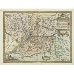
Lipsia..
On recto an early map of Germany, centered on Leipzig (117x155 mm).From a Latin text edition of his Geographia , that great compendium of Renaissance knowledge.
Date: Basle, 1550-1590
Selling price: ????
Please login to see price!
Sold in 2014
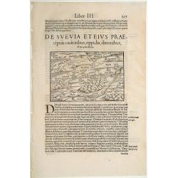
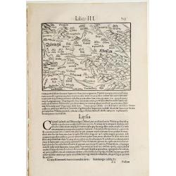
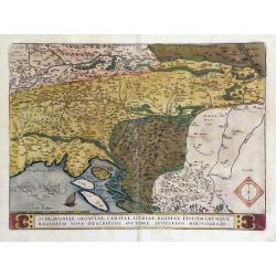
De Suevia et eius Praecipuis Civitatibus..
On recto an early map of south eastern part of Germany, including the towns of Fribourg, Zürich, Basel, Strasbourg, Heidelberg, Spire, etc. (Map : 117x155 mm).From a Lat...
Date: Basle, 1550-1590
Selling price: ????
Please login to see price!
Sold in 2014
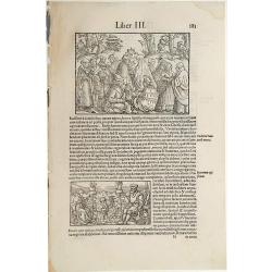
[Costumes of Schwaben)
On recto an early scene showing the costumes of the people of Schwaben. (Print : 95x135 mm).The second scene shows a couple ragging wool. From a Latin text edition of his...
Date: Basle 1550-1590
Selling price: ????
Please login to see price!
Sold
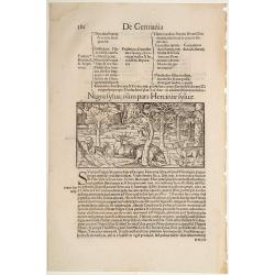
Nigra Sylva olim pars Herciniae Sylvae.
On recto an early scene showing the Foret Noire with different animals (a wolf, dear, bear, etc. (Print : 77x150 mm).From a Latin text edition of his Geographia , that gr...
Date: Basle 1550-1590
Selling price: ????
Please login to see price!
Sold
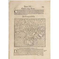
De Istria Peninsula.
On recto an early map of the province of Istria, including the Gulf of Triest (143x156 mm).From a Latin text edition of his Geographia , that great compendium of Renaissa...
Date: Basle 1550-1590
Selling price: ????
Please login to see price!
Sold
Natoliae..Aegypti Recentior..Carthaginis.. (3 maps on 1 sheet)
3 Maps on one sheet. Map to the left east to the top. Detailed map Turkey, including Cyprus and Crete. Also map of the Nile delta and another map of Tunis.
Date: Antwerp 1590
Selling price: ????
Please login to see price!
Sold
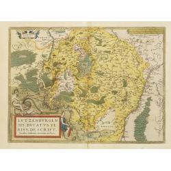
Lutzenburgen sis Ducatus Veriss. Descript
A attractive map of Luxembourg : title cartouche on the lower left corner. From 'Theatrum Orbis Terrarum [Atlas of the Whole World]'.Iacobo Surhonio Montano auctore.
Date: Antwerp, 1590
Selling price: ????
Please login to see price!
Sold
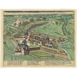
EYNDHOVEN - Nach dem Eindhoven mitt kriegs macht. . . .
Earliest printed bird's-eye view of Eindhoven. Showing the siege of April 13-23 1583. On April 22nd the young Count Carel van Mansfeld was taking the town after a 9 days ...
Date: Cologne, 1590
Selling price: ????
Please login to see price!
Sold in 2015
Als nun Truxes Reutter und knecht.. (Delft)
Early of Delft with a Spanish army entering the town.The plates by Hogenberg are dealing with the independence war of Holland against Spain.Recently a very interesting r...
Date: Cologne, 1590
Selling price: ????
Please login to see price!
Sold in 2017
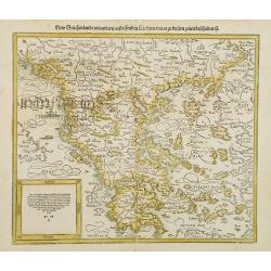
New Griechenlandt / mit andern anstoffenden Landern / wie es zu unsern zeiten bescreiben ist.
Double page woodcut map of mainland Greece and the islands from a German text edition of Münster's Cosmographia, that great compendium of Renaissance knowledge!. Headpie...
Date: Basle, ca. 1590
Selling price: ????
Please login to see price!
Sold in 2008
EYNDHOVEN - Nach dem Eindhoven mitt kriegs macht. . . .
Earliest printed bird's-eye view of Eindhoven. Showing the siege of April 13-23 1583. On April 22nd the young Count Carel van Mansfeld was taking the town after a 9 days ...
Date: Cologne, 1590
Selling price: ????
Please login to see price!
Sold in 2009
![Holandt. [Holland].](/uploads/cache/26999-250x250.jpg)
Holandt. [Holland].
On verso an early map of Holland (215x140 mm). From a German text edition of his Geographia , that great compendium of Renaissance knowledge.
Date: Basle, 1550-1590
Selling price: ????
Please login to see price!
Sold in 2010
Von der Bischofflichen Statt Utrecht..
An early representation of the city of Utrecht (125x155 cm). From a German text edition of his Geographia , that great compendium of Renaissance knowledge.
Date: Basle, 1550-1590
Selling price: ????
Please login to see price!
Sold in 2021
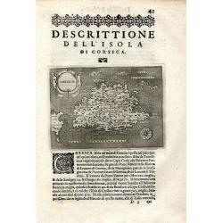
Descrittione Dell' Isola Di Corsica
Rare early map of the French island Corsica and a small part of Sardinia. Published around 1590 in "L'isole piu famose del mondo." Very detailed naming many s...
Date: Padova, ca. 1590
Selling price: ????
Please login to see price!
Sold in 2009

Descrittione Dell' Isola Di Corsica.
Rare early map of the French island Corsica and a small part of Sardinia. Published around 1590 in "L'isole piu famose del mondo." Very detailed map, naming man...
Date: Padova, ca. 1590
Selling price: ????
Please login to see price!
Sold in 2011

Venations Ferarum, Auium, Piscium. . .
Title page from "Venationes Ferarum, Avium, Piscium" or "Hunting Wild Beasts, Birds, Fish". The plate was engraved by Jan Collaert 1566-1628 published...
Date: Antwerp, 1590
Selling price: ????
Please login to see price!
Sold in 2013
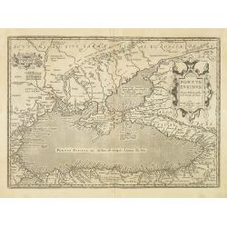
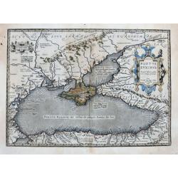
Pontus Euxinus Aequor Iafonio pulfatum remige premum.
Prepared by Ortelius after Mercator, and additional ancient sources as Plinius, Ovidius, Strabo, Apollonius, Procopius, and Apppianus.This map belongs to a series of hist...
Date: Antwerp, 1590
Selling price: ????
Please login to see price!
Sold in 2011
Andegavensium Ditionis Vera et Intregra Descriptio.
Decorative map centered on the Loire River and Angiers. Includes several bridges across the Loire and its tributaries.Prepared by Licimo Guyeto Andegauense.
Date: Antwerp, 1590
Selling price: ????
Please login to see price!
Sold in 2013
Schlavoniae, Croatiae, Carniae, Istriae, Bosniae, Finitimarumque Regionum Nova Descriptio, Auctore Augustino Hirsvogellio
Fine map of the Balkan region by Ortelius. Map is centered on the Sava River, and shows the current countries of Croatia, Bosnia and Herzegovina, Serbia and Slovenia.
Date: Antwerp, c. 1590
Selling price: ????
Please login to see price!
Sold in 2010
Andegavensium Ditionis Vera et Intregra Descriptio.
Early map of the Loire Valley, with Angiers in the center. Prepared by Lézin Guyet in 1579.
Date: Antwerp, 1590
Selling price: ????
Please login to see price!
Sold in 2010
Engellandt mit dem anstossenden Reich Schottlandt so vor zeiten Albion und Britannia haben geheissen.
A decorative map of Great Britain and eastern part of Ireland. Oriented to the west. Tablet in lower right corner with a brief commentary in German. Two ships and a sea-c...
Date: Basle, 1590
Selling price: ????
Please login to see price!
Sold in 2010
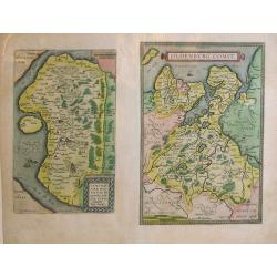
Thietmarsiae, Holsaticae Regionis Partis Typvs. Auctore Petro Boeckel. / Oldenbvrg Comit.
Two engraved maps on a folio sheet by Petro Boeckel of Germany. Published by Abraham Ortelius (1527-98) in his "Theatrum Orbis Terrarum".
Date: Antwerp, c.1590
Selling price: ????
Please login to see price!
Sold in 2010
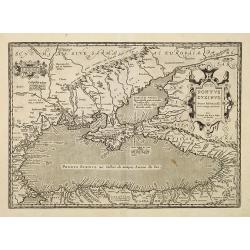
Pontus Euxinus Aequor Iafonio pulfatum remige premum.
Prepared by Ortelius after Mercator, and additional ancient sources as Plinius, Ovidius, Strabo, Apollonius, Procopius and Apppianus.This map belongs to a series of histo...
Date: Antwerp, 1590
Selling price: ????
Please login to see price!
Sold in 2010
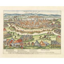
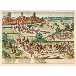
Belegerung der statt Maestricht Anno Drij MDLXXIX Im April.
Early print showing the siege of Maastricht under command of the sick Count Parma, June 29th 1579.The plates by Hogenberg are dealing with the independence war of Holland...
Date: Cologne, 1590
Selling price: ????
Please login to see price!
Sold in 2012
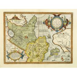
Tartariae sive magni Chami regni typus.
The map identifies China and Japan, but not Korea. The body of water lying between China and Japanese archipelago is identified as MARE CIN, which means China Sea.Much of...
Date: Antwerp, 1590
Selling price: ????
Please login to see price!
Sold in 2012
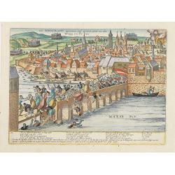
Wie Maestricht ingenomen und erobert wirdt. . .
Early print showing the siege of Maastricht under command of the sick Count Parma, June 29th 1579.The plates by Hogenberg are dealing with the independence war of Holland...
Date: Cologne, 1590
Selling price: ????
Please login to see price!
Sold in 2017
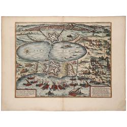
TUNES URBS ac Novae Eius Arcis et Guletae. Quae Philippo Hispan . . .
A striking old color example of Braun & Hogenberg's important early town view of Tunis. Text on verso. The image shows a siege of the port by Spanish ships under the ...
Date: Cologne, 1590
Selling price: ????
Please login to see price!
Sold in 2019
Africae propriae tabula. In qua, Punica regna uides; Tyrios, et Agenoris urbem.
The most beautiful early map of the northern coast of Africa available to the collector. Prepared by Ortelius himself. A very fine example. Ortelius based this map on tha...
Date: Antwerp,1590
Selling price: ????
Please login to see price!
Sold in 2020
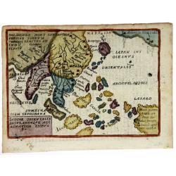
Indiae Orientalis Insularum Que Adi Acientium Tiipus.
A lovely, miniature map of south east Asia. With Latin text on verso.from an Italian edition of Ortelius Epitome atlas. Box title.
Date: Venice, ca. 1590
Selling price: ????
Please login to see price!
Sold in 2020
![Von dem Teutschen land. [Northern Germany]](/uploads/cache/45680-250x250.jpg)
Von dem Teutschen land. [Northern Germany]
A nice small map of northern Germany and a part of Poland. Shows the area between Lignitz and Torgau in the south, in the north Gdansk, the Baltic Sea and Holstein, in th...
Date: Basle, ca 1590
Selling price: ????
Please login to see price!
Sold in 2021
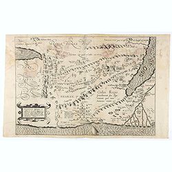
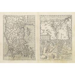
Pharan desertum, et confinia eius cum parte Aegypti, ea videlicet terrae regio . . .
Cristian van Adrichem's map of the Holy Land, depicting the Desert of Pharan or Paran and the Wandering of the Israelites. The map is oriented to the east and covers the ...
Date: Amsterdam, 1590
Selling price: ????
Please login to see price!
Sold in 2020
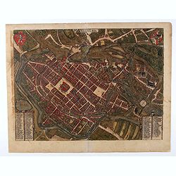
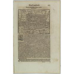
Wratislavia.
Decorative town-plan of the Polish city of Wroclaw, once known as Breslau, ornated with coat of arms in the upper corners. In the lower corners we find two tables with 91...
Date: Cologne, 1587-1590
Selling price: ????
Please login to see price!
Sold in 2020
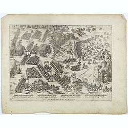
Philippus Scrossy Italianisscher Capitein uber des Bapstes kriegsher zogh hinein. . . Plate 65.
Early print showing the battle between Captain Stossi and the Hugonots at la Roche-l'Abeille on 5 June 1569.Plate from the series about the " Eighty Years War" ...
Date: Cologne, ca. 1590
Selling price: ????
Please login to see price!
Sold in 2023
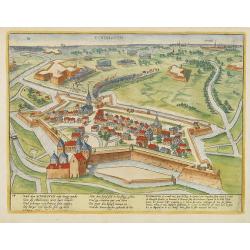
Flensburg and Itzehoe.
Flensburg: This view from the east of the harbour city at the end of the Flensburg Fjord shows the long merchants' yards that are typical of old Flensburg - front-gabled ...
Date: Cologne, ca 1590
Selling price: ????
Please login to see price!
Sold in 2022
![Brixiani Agri Typus [Brescia].](/uploads/cache/47101-250x250.jpg)
Brixiani Agri Typus [Brescia].
A very nice map of northern province of Italy, Brecia. Copied after a map prepared in 1560 by Christoforo Sorte. Very large title cartouche on the lower left corner. Abra...
Date: Antwerp, 1590
Selling price: ????
Please login to see price!
Sold in 2021
![Taprobana. [Sri Lanka]](/uploads/cache/47369-250x250.jpg)
Taprobana. [Sri Lanka]
An attractive map of the island of Ceylon, or Sri Lanka, with north orientated to the right. Third edition from Porcacchi's L'isole piu famose.It features a pretty strap-...
Date: Venice, 1590
Selling price: ????
Please login to see price!
Sold in 2021
![[Lot of 11 maps of Persia] Reyno de Persia, o imperia de los Sophies/ Pereici sive Sophorum Regni Ypus](/uploads/cache/18512-(3)-250x250.jpg)
[Lot of 11 maps of Persia] Reyno de Persia, o imperia de los Sophies/ Pereici sive Sophorum Regni Ypus
Abraham Ortelius( 1527-98), Dutch cartographer and publisher of the first modern atlas, ' Theatrum Orbis Terrarum' in 1570. Editions till 1612. Also an atlas of ancient c...
Date: Antwerp, c. 1590
Selling price: ????
Please login to see price!
Sold in 2022
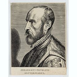
Abrahamus Ortelius Antverpianus.
Portrait of Abraham Ortelius, made by Philippe Galle. Abraham Ortelius (April 14, 1527 - June 28, 1598) was a Flemish cartographer and geographer. Beginning as a map-engr...
Date: Paris, ca. 1590
Selling price: ????
Please login to see price!
Sold in 2022
![[Showing the 1588 defeat of the Spanish Armada in the English Channel]](/uploads/cache/20220907_173700-250x250.jpg)
[Showing the 1588 defeat of the Spanish Armada in the English Channel]
Beautiful engraving by Michael Eytzinger, showing the 1588 defeat of the Spanish Armada in the English Channel. Latin text on verso. Published in Leonis Belgici Descript...
Date: Cologne, ca. 1590
Selling price: ????
Please login to see price!
Sold in 2022
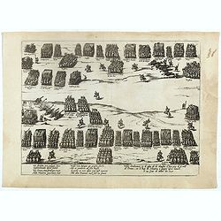
(Possitions of a battle at Ivry (Dreux), 1590 )
Early print showing the positions of a battle at Ivry (Dreux), 1590..Plate from the series about the " Eighty Years War" or the independence war of Holland agai...
Date: Cologne, ca. 1590
Selling price: ????
Please login to see price!
Sold in 2022
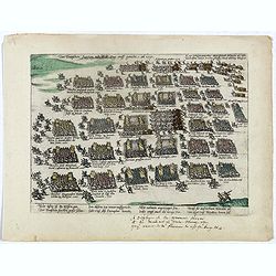
Der Teutschen fursten neu Wer zug auff gericht an 1591.
Early print showing the troops of German princes en route to France, 1591.Plate from the series about the " Eighty Years War" or the independence war of Holland...
Date: Cologne, ca. 1590
Selling price: ????
Please login to see price!
Sold in 2022
![[Set of 5 maps of the Holy Land: Paradise, Canaan, Israel & Egypt, the Eastern Mediterranean. . .]](/uploads/cache/48407-250x250.jpg)
[Set of 5 maps of the Holy Land: Paradise, Canaan, Israel & Egypt, the Eastern Mediterranean. . .]
A lovely set of biblical maps of the Holy Land and its surrounds and, the Eastern Mediterranean by Cloppenburg, and engraved by Baptista Deuticum. The first map is an ear...
Date: Amsterdam, ca 1590
Selling price: ????
Please login to see price!
Sold in 2022
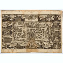
Waerachtige beschryvinge vande wydvermaerde Conincklicke Hooft Stadt Jerusalem. . .
A truly beautiful copper engraved plan of Jerusalem by Baptista van Doetechum for a bible printed by Jan Everts Cloppenburg. The bible maps of 1590 are the earliest of Pl...
Date: Amsterdam, ca 1590
Selling price: ????
Please login to see price!
Sold in 2022
![La Florida [with] Guastecan](/uploads/cache/florida_01-250x250.jpg)
La Florida [with] Guastecan
A fine, old-colored example of Abraham Ortelius’ seminal map of Florida and the North American South. Ortelius’ map La Florida was the foundation for cartography ...
Date: Antwerp, 1590
Selling price: ????
Please login to see price!
Sold in 2023
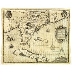
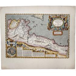
Floridae Americae Provinciae recens & exactissima descriptio . . .
A superb map of the Eastern Seaboard from Cape Lookout to Florida, with Cuba and the Bahamas, by the official artist of the second French Huguenot expedition to their col...
Date: Frankfurt, 1591
Selling price: ????
Please login to see price!
Sold in 2012
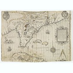
Floridae Americae Provinciae recens & exactissima descriptio . . .
A superb map of the Eastern Seaboard from Cape Lookout to Florida, with Cuba and the Bahamas, by the official artist of the second French Huguenot expedition to their col...
Date: Frankfurt, 1591
Selling price: ????
Please login to see price!
Sold in 2014
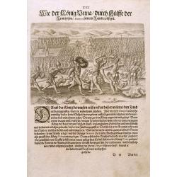
French battle with Florida Indians, 1591
Exciting de Bry engraving from 'der ander Theil der newlich erfundenen Landtschafft Americae' showing French soldiers aiding native North Americans in a war against a riv...
Date: Frankfurt, c.1591
Selling price: ????
Please login to see price!
Sold in 2014
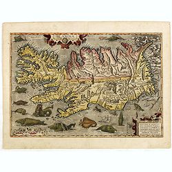
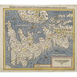
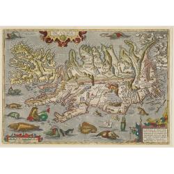
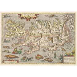
Islandia.
Perhaps the most famous map of Iceland. On the south side of the island a collection of all possible sea monsters is depicted. Polar bears on ice flows and volcanoes in t...
Date: Antwerp, 1591
Selling price: ????
Please login to see price!
Sold in 2015
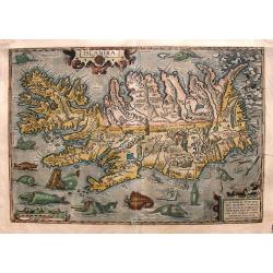
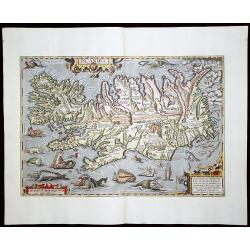
Islandia
From the 1591 German edition of the Theatrum (75 copies printed). Probably the most famous map of Iceland. The lower part of this map features a big collection of sea mon...
Date: Antwerp, 1591
Selling price: ????
Please login to see price!
Sold in 2015
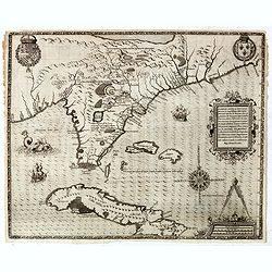
Floridae Americae Provinciae recens & exactissima descriptio . . .
A superb map of the Eastern Seaboard from Cape Lookout to Florida, with Cuba and the Bahamas, by the official artist of the second French Huguenot expedition to their col...
Date: Frankfurt, 1591
Selling price: ????
Please login to see price!
Sold in 2019
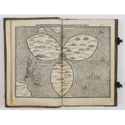
Itinerarium sacrae scripturae. . .
A relatively early edition of this famous book includes a world map in a cloverleaf (Shirley 142). The three principal continents, Europe, Asia, and Africa, are arranged ...
Date: Magdeburg, 1591
Selling price: ????
Please login to see price!
Sold in 2013
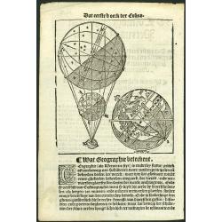
Printed leaf with woodcut globe.
Decorative page from a Dutch edition of Cosmographie, oft Beschrijuinge der geheelder Werelt. The author's first major work and one of the most popular texts of the 16th ...
Date: Antwerp, 1592
Selling price: ????
Please login to see price!
Sold in 2011

Spectandum Dedit Ortelius Mortalib. orbem Orbi Spectandum Galleus Ortelium. Papius
A beautiful colored portrait of Abraham Ortelius as Frontispiece to his 'Theatrum Orbis'. Engraved by Phillipe Galle.
Date: Antwerp, 1592
Selling price: ????
Please login to see price!
Sold in 2015
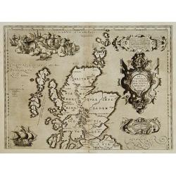
Britannicarum Insularum Vetus Descriptio.
Scarce. The upper sheet of a two-sheet map which was issued with the Parergon 1590 and repeated only in the Parergon 1591 and Theatrum 1592 (as present). According to Mar...
Date: Antwerp 1592
Selling price: ????
Please login to see price!
Sold
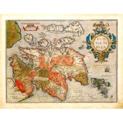
Scotiae Tabula.
From the Theatrum Orbis Terrarum, 1592.A fine general map of Scotland with north to the right of the page.Ortelius derived this map from Mercator's 1564 map of the Britis...
Date: Antwerp, 1592
Selling price: ????
Please login to see price!
Sold
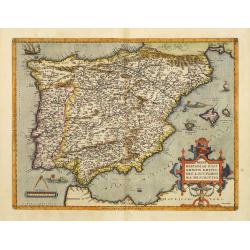
Regni Hispaniae Post Omnium Editio..
Very decorative map of Spain and Portugal including Majorca and Minorca.
Date: Antwerp 1592
Selling price: ????
Please login to see price!
Sold
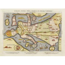
Europa Prima Pars Terrae Forma Virginis.
Desirable, famous and extremely rare issue of this famous map of Europe, depicted in the form of a Queen wearing her crown and in flowing robes.This is a very rare issue...
Date: Magdeburg, ca. 1592
Selling price: ????
Please login to see price!
Sold
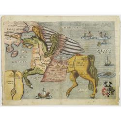
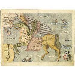
Asia is presented as the mythical winged horse Pegasus.
Copper engraved map of Asia in the form of a Pegasus. This is a very rare issue of the map from a Czech edition. The original woodcut map was re-engraved on copper with a...
Date: Magdeburg, 1592
Selling price: ????
Please login to see price!
Sold
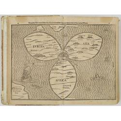
Itinerarium Sacrae Scripturae. Das ist: Ein Reisebuch uber die gantze heilige Schrifft. Zuvor gemehret mit einem Büchlein De monetis et mensuris. . .
The book includes a world map in the form of a clover leaf (Shirley 142). The three principal continents, Europe, Asia and Africa, are arranged in the form of a clover le...
Date: Magdeburg, P. Donat for A. Kirchner, 1592
Selling price: ????
Please login to see price!
Sold in 2009
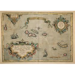
Açores Insulae.
The importance of the Azores at that time was connected with the observation of Columbus that compass variation (i.e. the difference between the real and the magnetic nor...
Date: Antwerp, 1592
Selling price: ????
Please login to see price!
Sold in 2009
Islandia.
Perhaps the most famous map of Iceland. On the south side of the island a collection of all possible sea monsters is depicted. Polar bears on ice flows and volcanoes in t...
Date: Antwerp, 1592
Selling price: ????
Please login to see price!
Sold in 2009
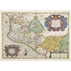
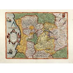
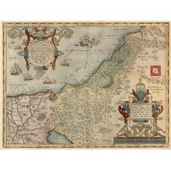
Hispaniae Novae.
This was the standard map of the area for a generation, copied by Quad and Hondius. Even though Herrera (Spain's Royal Cosmographer) and Wytfliet worked 20 years after Or...
Date: Antwerp, 1592
Selling price: ????
Please login to see price!
Sold in 2009
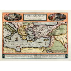
Peregrinationis divi Pauli typus corographicus
Hand colored map of the Eastern Mediterranean by Abraham Ortelius. Covering the Mediterranean Sea between Israel and Sicily with Cyprus, Italy, Greece and Turkey. With tw...
Date: Antwerp, 1592
Selling price: ????
Please login to see price!
Sold in 2010
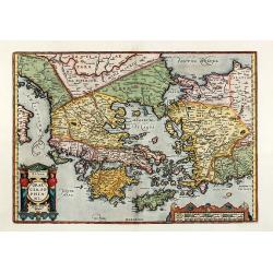
Hellas. Graecia, Sophiani
colored engraved map of Greece by A. Ortelius. Showing Greece with the Greek Islands, Crete, Asia Minor and the Aegean Sea. From the 1592 Latin edition of 'Theatrum Orbis...
Date: Antwerp, 1592
Selling price: ????
Please login to see price!
Sold in 2010
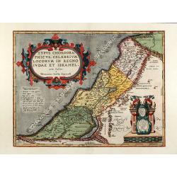
Typus chorographicus, celebrium locorum in regno Iudae et Israhel
Beautiful colored map of the Holy Land by A. Ortelius. The map is based on T. Stella's map of 1552, with two large Renaissance cartouches. From the 1592 Latin edition of ...
Date: Antwerp, 1592
Selling price: ????
Please login to see price!
Sold in 2010
Ducatus Mediolanensis, Finitimarumq Regionu Descriptio Auctore Iooanne Georgio Septala Mediolanense
Beautiful colored map of northern Italy by A. Ortelius. Showing the area around Milan with Lago di Como, Genoa, Parma, Cremona and Bergamo. With a nice Renaissance cartou...
Date: Antwerp, 1592
Selling price: ????
Please login to see price!
Sold in 2010
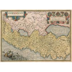
Terra Sancta.
Holy Land of the 'Theatrum Orbis Terrarum', described by Petrus Laicstain and designed by Chistian Schrot. Oriented to the east. Shows the shore line from Beirut to Gaza....
Date: Antwerp, 1592
Selling price: ????
Please login to see price!
Sold in 2010
Palestinae sive totius terraepromissionis nova descriptio auctore tilemanno stella sigensis.
Holy Land from the 'Theartrum Orbis Terrarum'.
Date: Antwerp, 1592
Selling price: ????
Please login to see price!
Sold in 2010
Asia is presented as the mythical winged horse Pegasus.
Copper engraved map of Asia in the form of a Pegasus. This is a very rare issue of the map from a Czech edition. The original woodcut map was re-engraved on copper with a...
Date: Magdeburg, 1592
Selling price: ????
Please login to see price!
Sold in 2010
Islandia.
Perhaps the most famous map of Iceland. On the south side of the island a collection of all possible sea monsters is depicted. Polar bears on ice flows and volcanoes in t...
Date: Antwerp, 1592
Selling price: ????
Please login to see price!
Sold in 2012
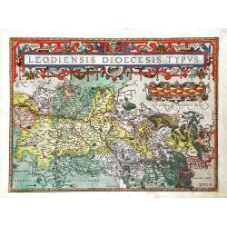
Leodiensis Dioecesis Typus
Map of eastern Belgium region from Ortelius' Theatrum Orbis Terrarum. Shows the Meuse River and the cities located on the river, such as Namur, Liege and Maastricht. A be...
Date: Antwerp, 1592
Selling price: ????
Please login to see price!
Sold in 2010
Islandia.
Perhaps the most famous map of Iceland. On the south side of the island a collection of all possible sea monsters is depicted. Polar bears on ice flows and volcanoes in t...
Date: Antwerp, 1592
Selling price: ????
Please login to see price!
Sold in 2010
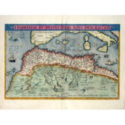
Barbariae Et Biledvlgerid, Nova Descriptio.
Attractive map of Africa by Abraham Ortelius. The map covers the area on the north-west coast of Africa from about present day Senegal and "Fume del Oro"...
Date: Antwerp, (1570) 1592
Selling price: ????
Please login to see price!
Sold in 2011
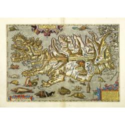
Islandia.
Perhaps the most famous map of Iceland. On the south side of the island a collection of all possible sea monsters is depicted. Polar bears on ice flows and volcanoes in t...
Date: Antwerp, 1592
Selling price: ????
Please login to see price!
Sold in 2011
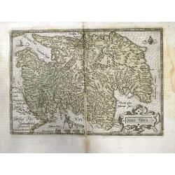
Scotiae Tabula.
Scarce map of Scotland based on Ortelius. North orientated to the right. Very detailed with many place names. Decorated with sailings ships, a fox holding dividers above ...
Date: Cologne, 1592
Selling price: ????
Please login to see price!
Sold in 2011
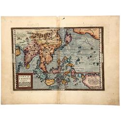
INDIA ORIENTALIS. Cuius nobilior pars sunt duo-ista quasi ingentia totius Asiae promontoria in Oceanum versus Meridiem . . .
Matthäus Quad's uncommon map depicts most of the Asian continent stretching northward to encompass Japan and eastward to show the coast of North America and New Guinea. ...
Date: Cologne, ca. 1592
Selling price: ????
Please login to see price!
Sold in 2022
Pontus Euxinus Aequor Iafonio pulfatum remige premum.
An early map of the Black Sea, Sea of Azov, and its coasts which includes parts of Turkey, Armenia, Georgia, Russia, Ukraine, Crimea, Moldova, Romania, and Bulgaria. It s...
Date: Antwerp, 1592
Selling price: ????
Please login to see price!
Sold in 2020