Browse Listings
Wer lustig ist zu Wissen gar. . .
Plate from the series about the " Eighty Years' War" or the independence war of Holland against Spain, we know approximately four hundred engravings by Frans Ho...
Date: Cologne, ca. 1590
Selling price: ????
Please login to see price!
Sold in 2020
Hertzog Friedrich von Wirtenbergh. . .
Early print showing count Friedrich von Wirtenbergh receiving the English equestrian order on 16 November 1603 in Stuttgart.Plate from the series about the " Eighty ...
Date: Cologne, ca. 1590
Selling price: ????
Please login to see price!
Sold in 2019
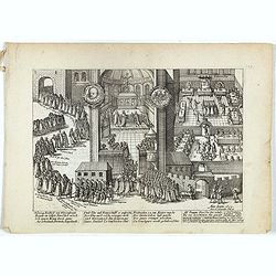
Beim Colnschen Sant Jeronim Machtelis. . .
Early print showing a beheading in Cologne.Plate from the series about the " Eighty Years' War" or the independence war of Holland against Spain, we know of app...
Date: Cologne, ca. 1590
Selling price: ????
Please login to see price!
Sold in 2018
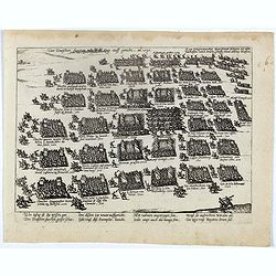
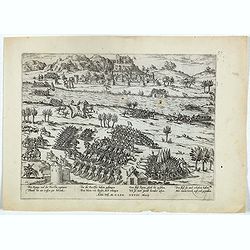
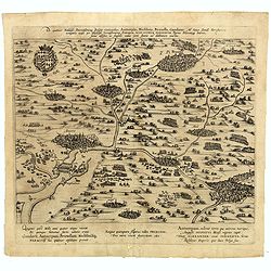
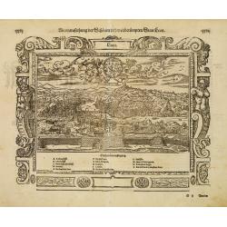
Hie siechstu wie gelegen seint . . Plate 261.
Early print showing an army position near the town of Dreux in France on 14 March 1590 during the French Wars of Religion.Plate from the series about the " Eighty Ye...
Date: Cologne, ca. 1590
Selling price: ????
Please login to see price!
Sold in 2020
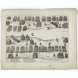
Des Konigs undder Fursten regiment . . . Plate 32.
Plate from the series about the " Eighty Years' War" or the independence war of Holland against Spain, we know of approximately four hundred engravings by Frans...
Date: Cologne, ca. 1590
Selling price: ????
Please login to see price!
Sold in 2020
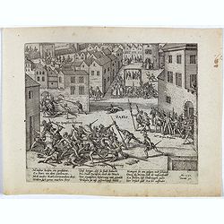
PARIS
Early print showing the capture of Barnabé Brisson in Paris, who was hanged on 15 November by the Spanish.Plate from the series about the " Eighty-Years War" o...
Date: Cologne, ca. 1590
Selling price: ????
Please login to see price!
Sold in 2020
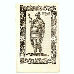
Indo di Conditione.
Full portrait of a woman and two children from India, by Cesare Vecellio (1521–1601). From "De gli habiti antichi, e moderni di diverse parti del mondo libri du du...
Date: Venice, Damian Zenaro, 1590
Selling price: ????
Please login to see price!
Sold in 2017
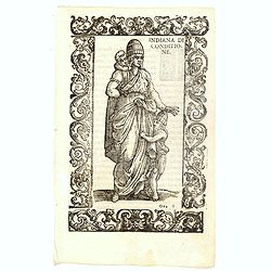
Indiana Di Conditione.
Full portrait of a woman and two children from India, by Cesare Vecellio (1521–1601). From "De gli habiti antichi, e moderni di diverse parti del mondo libri du du...
Date: Venice, Damian Zenaro, 1590
Selling price: ????
Please login to see price!
Sold in 2017
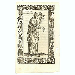
Indiana Mediocre.
Full portrait of a woman and two children from India, by Cesare Vecellio (1521–1601). From "De gli habiti antichi, e moderni di diverse parti del mondo libri du du...
Date: Venice, Damian Zenaro, 1590
Selling price: ????
Please login to see price!
Sold in 2017
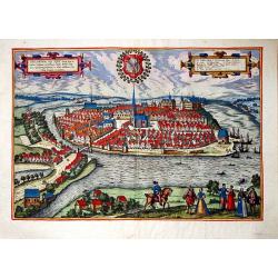
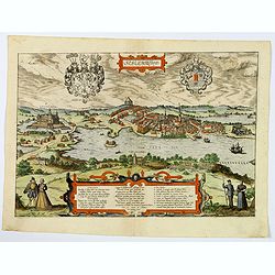
Chilonium, vulgo Kyell.
A rare, large, spectacular view of the German city of Kiel. From the famous 'Civitates Orbis Terrarum' of Braun & Hogenberg, with spectacular old colors, partly enhan...
Date: Cologne, 1590
Selling price: ????
Please login to see price!
Sold in 2017
Bergen.
A spectacular, large, rare view of Bergen, from the famous 'Civitates Orbis Terrarum' of Braun & Hogenberg. Bergen was founded in 1070, during the warm medieval perio...
Date: Cologne, 1590
Selling price: ????
Please login to see price!
Sold in 2018
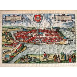
Monachium Utriusque Bavariae Civitas Primar.
A panoramic view of the city of Munich and its environs, as seen from the east from the famous civitates orbis terrarum of Braun & Hogenberg. Note, left in the backgr...
Date: Cologne, ca 1590
Selling price: ????
Please login to see price!
Sold in 2017
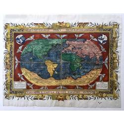
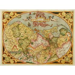
Universalis Orbis Descriptio.
Very scarce woodcut map of the world on an oval projection, published in Opusculum Geographicum Rarum. Myritius reverts to a style of map more reminiscent of the 1550s an...
Date: Ingolstadt, 1590
Selling price: ????
Please login to see price!
Sold in 2019
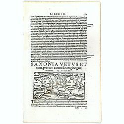
Saxonia Vetus et Nova . . .
Text sheet with on recto an early map of Saxony, centered on Berlin and including Hamburg and Danzig as well (map : 69x134 mm). South to the top.From a Latin text edition...
Date: Basle 1550-1590
Selling price: ????
Please login to see price!
Sold in 2017
![Taprobana. [Sri Lanka]](/uploads/cache/39986-250x250.jpg)
Taprobana. [Sri Lanka]
An attractive map of the island of Ceylon, or Sri Lanka, with north orientated to the right.Third edition from Porcacchi's L'isole piu famose.It features a pretty strap-w...
Date: Venice, 1590
Selling price: ????
Please login to see price!
Sold in 2017
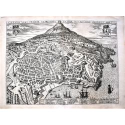
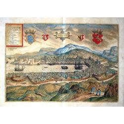
Catana urbs Siciliae clarissima patria sc.te Agathae virgin. . .
A large, beautiful print of the Italian city of Catania, in Sicily, with Mount Etna in the background, one of the most impressive volcanos in Europe. It comes from the gr...
Date: Cologne, 1590
Selling price: ????
Please login to see price!
Sold in 2018
Chilonium, vulgo Kyell.
A rare, large, spectacular view of the German city of Kiel. From the famous 'Civitates Orbis Terrarum' of Braun & Hogenberg, with spectacular old color. With French t...
Date: Cologne, 1590
Selling price: ????
Please login to see price!
Sold in 2019
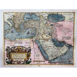
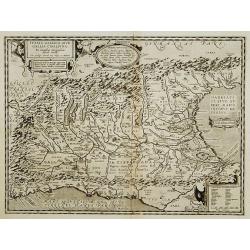
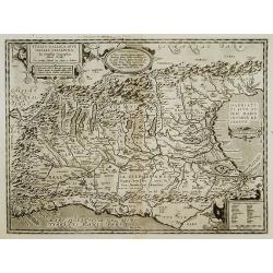
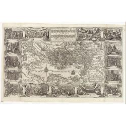
Turcici Imperii Descriptio.
A fine map of the Middle East, extending from Greece to Arabia, and covering the “Cradle of Civilisation” region. It features the Arabian Peninsula prominently and il...
Date: Antwerp, ca. 1590
Selling price: ????
Please login to see price!
Sold in 2017
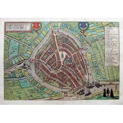
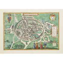
Gouda, elegantiß Hollandiae...
A highly detailed 16th-century birds-eye perspective plan of Gouda, with numerous buildings, streets, places, churches, and squares, together with the city walls, the har...
Date: Cologne, ca. 1590
Selling price: ????
Please login to see price!
Sold in 2017
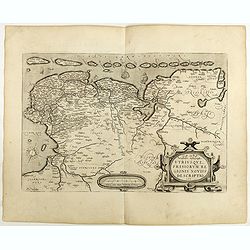
Utriusque Frisiorum Regionis Noviss Descriptio.
From 'Theatrum Orbis Terrarum [Atlas of the Whole World]'. Dare to go in Black. All early maps were printed in black and white, and many were kept that way for a long t...
Date: Antwerp, 1590
Selling price: ????
Please login to see price!
Sold in 2018
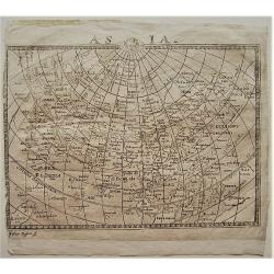
Asia.
An attractive map of the Asian continent by Rosaccio who was an Italian cartographer and the author of several atlases which were re-issued in various Italian cities from...
Date: ca. 1590
Selling price: ????
Please login to see price!
Sold in 2018
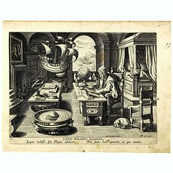
Lapis polaris magnes.
This is a plate from a series of twenty prints illustrating new inventions and discoveries (Nova Reperta) after Jan van der Straet. Plated numbered 2. Lettered in margin,...
Date: Antwerp, Philips Galle, c. 1590
Selling price: ????
Please login to see price!
Sold in 2018
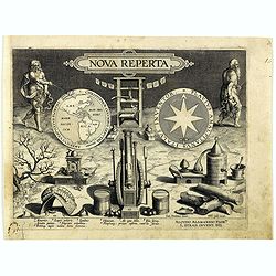
Nova reperta.
Title-page from a series of twenty prints illustrating new inventions and discoveries (Nova Reperta) after Jan van der Straet. Lettered on image: 'NOVA REPERTA'; on left ...
Date: Antwerp, Philips Galle, c. 1590
Selling price: ????
Please login to see price!
Sold in 2018
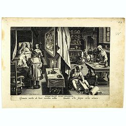
Hyacum et lues venera
This is a plate from a series of twenty prints illustrating new inventions and discoveries (Nova Reperta) after Jan van der Straet. Plated numbered 6. Lettered in margin,...
Date: Antwerp, Philips Galle, c. 1590
Selling price: ????
Please login to see price!
Sold in 2018
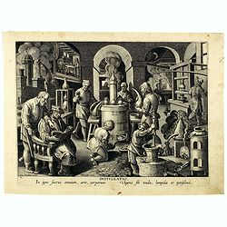
Distillatio.
This is a plate from a series of twenty prints illustrating new inventions and discoveries (Nova Reperta) after Jan van der Straet. Plated numbered 7. Lettered in margin,...
Date: Antwerp, Philips Galle, c. 1590
Selling price: ????
Please login to see price!
Sold in 2018
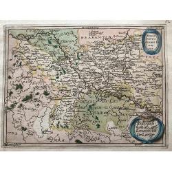
Episcopatus Leodiensis / Bisthumsg. Luttich Leuesche De Liege.
A very rare map of the area around Liege. Extends until Frankfurt, Namur and Antwerp. Engraved by Frans Hogenberg for an Atlas by Johannes Metellus!
Date: Cologne, ca 1590
Selling price: ????
Please login to see price!
Sold in 2018
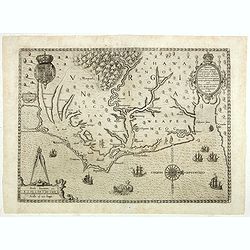
![[The Englishmen's arrival in Virginia with Roanoke Colony - Carolina Coastline] No title.](/uploads/cache/42117-250x250.jpg)
[The Englishmen's arrival in Virginia with Roanoke Colony - Carolina Coastline] No title.
Map showing the coast of Virginia with many islands just off the mainland, two Native territories, Secotan and Weapemeoc, and the Native community of Roanoak on an island...
Date: Frankfurt, c. 1590
Selling price: ????
Please login to see price!
Sold in 2018
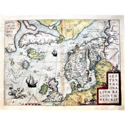
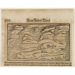
Septentrionalium Regionum Descrip.
An influential map of the Arctic. It includes Scandinavia, Iceland, Greenland and part of the North American continent, together with the legendary islands of the north: ...
Date: Antwerp, 1590
Selling price: ????
Please login to see price!
Sold in 2018
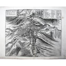
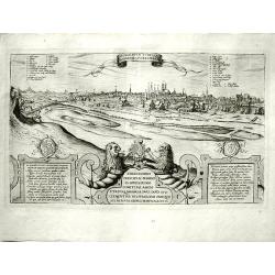
Perusia gratu musis in Tuscia domicilium. (Perugia)
A large, early, very detailed, strong impression, bird's-eye view of the Italian city of Perugia. From the famous Civitates Orbis Terrarum, compiled and written by George...
Date: Cologne, 1590
Selling price: ????
Please login to see price!
Sold in 2020
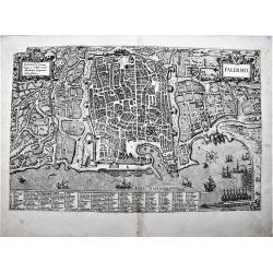
Panormus / Palermo.
A large, early, very detailed, strong impression, bird's-eye view of the Italian city of Palermo in Sicily. From the famous Civitates Orbis Terrarum, compiled and written...
Date: Cologne, 1590
Selling price: ????
Please login to see price!
Sold in 2018
MOSCAVW.
From the famous Civitates Orbis Terrarum of Braun and Hogenberg, one of the most sought after early views of Moscow. It depicts the city from an elevated viewpoint across...
Date: Cologne, 1590
Selling price: ????
Please login to see price!
Sold in 2020
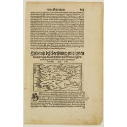
Chilonium vulgo Kyell. . .
COMMENTARY BY BRAUN: "Where the Belt meets the Duchy of Schleswig-Holstein and Schleswig, it has numerous bends forming narrow necks of land notably surrounded by wa...
Date: Cologne, ca 1590
Selling price: ????
Please login to see price!
Sold in 2018
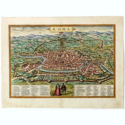
Roma.
Though a contemporaneous view, the structures of Ancient Rome are still much in evidence. The example contains a 119 point legend and figures in typical costume.From the ...
Date: Cologne, 1590
Selling price: ????
Please login to see price!
Sold in 2019
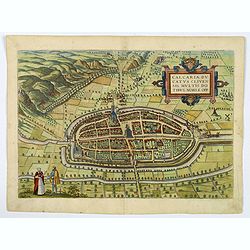
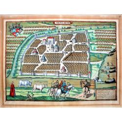
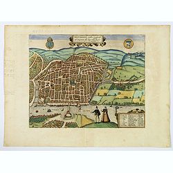
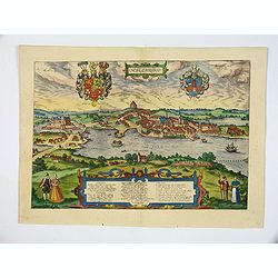
Kalcar.
An early town plan of Kalkar in Germany, showing an enclosed town with many fine houses and buildings, especially the town hall, the market place and the main church. The...
Date: Cologne, 1590
Selling price: ????
Please login to see price!
Sold in 2020
![[Matiscona / Chalon-sur-Soane].](/uploads/cache/43146-250x250.jpg)
[Matiscona / Chalon-sur-Soane].
MACON: This is a bird's-eye view from the south of the town, which is fortified with moats, walls and bastions. With numerous churches, including the Gothic cathedral of ...
Date: Cologne, ca 1590
Selling price: ????
Please login to see price!
Sold in 2019
![[Hesdin]. Hesdinum. . .](/uploads/cache/43147-250x250.jpg)
[Hesdin]. Hesdinum. . .
A perspective birds-eye view of the northern French city of Hesdin. It lies in the 'Pay-de-Calais region. The city is dominated by a large town square and the church of N...
Date: Cologne, ca 1590
Selling price: ????
Please login to see price!
Sold in 2019
RHOTOMAGUS Galliae... Rouen.
A lovely bird's-eye plan of Rouen by Braun and Hogenberg, with a French key to locations. Two costume figures at bottom. This bird's-eye view from the north conveys a cle...
Date: Cologne, ca 1590
Selling price: ????
Please login to see price!
Sold in 2019
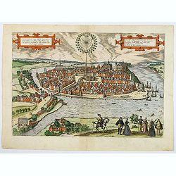
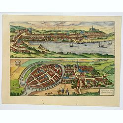
Schleswig. . .
The ducal coat of arms and the arms of the city of Schleswig at the corners of an equilateral triangle draw attention down to the little church of Hedeby in the foregroun...
Date: Cologne, ca 1590
Selling price: ????
Please login to see price!
Sold in 2019
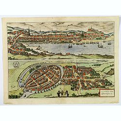
Flensburg and Itzehoe.
Flensburg: This view from the east of the harbour city at the end of the Flensburg Fjord shows the long merchants' yards that are typical of old Flensburg - front-gabled ...
Date: Cologne, ca 1590
Selling price: ????
Please login to see price!
Sold in 2020
![[St. Omer]. S. Audomari Fanum A. Aulmer. Omer Iccius portus Abrahamo Orttelio, artesij urbs munitissima.](/uploads/cache/43145-250x250.jpg)
[St. Omer]. S. Audomari Fanum A. Aulmer. Omer Iccius portus Abrahamo Orttelio, artesij urbs munitissima.
This is a bird's-eye view from the south of the town, which is fortified with moats, walls and bastions. Numerous churches stand out, including the Gothic cathedral of No...
Date: Cologne, ca 1590
Selling price: ????
Please login to see price!
Sold in 2020
Flensburg and Itzehoe.
Flensburg: This view from the east of the harbour city at the end of the Flensburg Fjord shows the long merchants' yards that are typical of old Flensburg - front-gabled ...
Date: Cologne, ca 1590
Selling price: ????
Please login to see price!
Sold in 2020
Gottorp.
The ducal coat of arms and the arms of the city of Schleswig at the corners of an equilateral triangle draw our attention down to the little church of Hedeby in the foreg...
Date: Cologne, ca 1590
Selling price: ????
Please login to see price!
Sold in 2020
De quator Nobilis Potentissimisq Belgicae Civitativus Antverpia, Mechlinia, Bruxella, Grandauo . . .
Early print showing a army position near the town of Dreux in France on 14 March 1590 during the French Wars of Bird's-eye view map of Brabant, showing Antwerp, Gent, Vil...
Date: Cologne, 1590
Selling price: ????
Please login to see price!
Sold in 2021
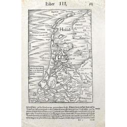
Holad.
A very early woodcut map from a Latin edition of Münsters famous 'Cosmographie'. It shows the area from Ameland until Bergen including many famous cities. With a ship sh...
Date: Basel, ca 1590
Selling price: ????
Please login to see price!
Sold in 2019
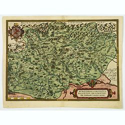
Burgundiae Comitatus Recentiss. Descriptio.
A decorative and attractive regional map of Burgundy in France, that is centered on Besancon, Poligny, Quingey and St Anne. It includes a number of famous wine regions, f...
Date: Antwerp, ca 1590
Selling price: ????
Please login to see price!
Sold in 2020
Americae pars, Nunc Virginia dicta, primum ab Anglis. . .
John White's map, elegantly designed and superbly engraved, revolutionized geographic knowledge of the region. Although White left the Chesapeake poorly explored, much of...
Date: Frankfurt, 1590
Selling price: ????
Please login to see price!
Sold in 2019
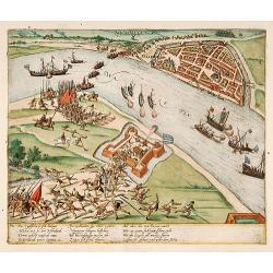
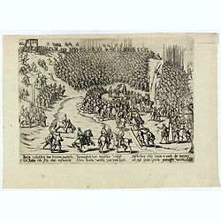
Die Englischen so sich.. (Nijmegen, Anno 1586)
Early print showing Nijmegen, river Waal and fort Knodsenburg.The plates by Hogenberg are dealing with the independence war of Holland against Spain.Recently a very inter...
Date: Cologne 1590
Selling price: ????
Please login to see price!
Sold
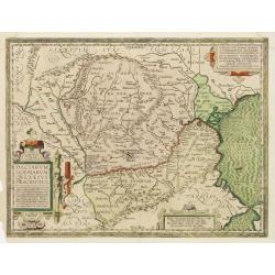
Daciarum, Moesiarumaue Vetus Descriptio.
Decorative ancient map of Hungary. From his historical atlas including a series of maps prepared by Ortelius himself. Signed lower left hand corner Ex conatibus Abrahami ...
Date: Antwerp, 1590
Selling price: ????
Please login to see price!
Sold in 2009
![[Two maps of Germany]](/uploads/cache/14379-250x250.jpg)
[Two maps of Germany]
Two sheets. One map centered on the river Rhine with the towns of Basle, Zürich, Augsburg, Esling, Strasbourg, Fribourg, etc. The second map showing eastern part of Germ...
Date: Basle 1550-1590
Selling price: ????
Please login to see price!
Sold
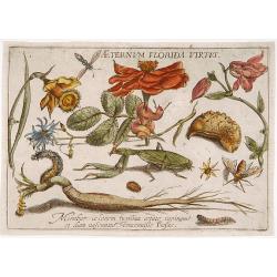
Aeternum Florida Virtus
Board representing plants and insects.Joris Hoefnagel (Anvers 1542-Vienne 1600) was a painter, illuminator and draughtsman of flowers, fruits, insects, etc. He became the...
Date: Antwerp 1590
Selling price: ????
Please login to see price!
Sold
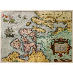
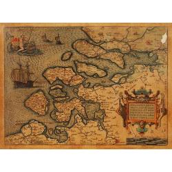
Zelandicarum Insularum Exactissima et Nova Descriptio.
From 'Theatrum Orbis Terrarum [Atlas of the Whole World]', The Theatrum was re-issued in 42 editions with 5 supplements with text in Latin, Dutch, German, French, Spanish...
Date: Antwerp 1590
Selling price: ????
Please login to see price!
Sold
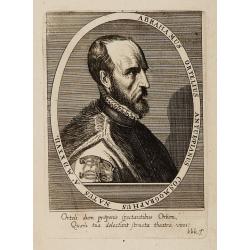
Abrahamus Ortelius Antwerpianus cosmographus natus..
Rare head and shoulder portrait of Abraham Ortelius.
Date: Antwerp c.1590
Selling price: ????
Please login to see price!
Sold
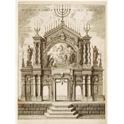
Apotheosis d. Isabellae Clarae Eugeniae.
Architectural frontage after design by P.P.Rubens. Engraved and published by Ta Thul.
Date: Antwerp, c.1590
Selling price: ????
Please login to see price!
Sold in 2009
Descriptio Germaniae Inferioris.
The oval map is surrounded by a strapwork frame and the title, adorned with ribbons, is held aloft by two winged cherubs.
Date: Antwerp 1590
Selling price: ????
Please login to see price!
Sold
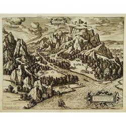
Tempe.
An attractive view of Mount Olympus and the valley in northern Thessaly (Greece), called the Vale of Tempe in ancient times, through which the river Peneus (present-day S...
Date: Antwerp 1590
Selling price: ????
Please login to see price!
Sold
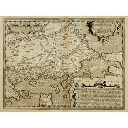
Thraciae Veteris Typus.
Made by Ortelius based on Gastaldi's 1560 map, which covers an area that includes North-Eastern Greece, Southern Bulgaria, and North-West Turkey. The information is based...
Date: Antwerp 1590
Selling price: ????
Please login to see price!
Sold
Germaniae Veteris typus.
Made by Ortelius based on the writings by the ancient authors Tacitus, Caesar, Dionysus, Ptolemy, Suetonius, Eutropius, Seneca, Plinius, and Strabo.This map belongs to a ...
Date: Antwerp 1590
Selling price: ????
Please login to see price!
Sold
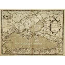
Pontus Euxinus Aequor Iafonio pulfatum remige premum.
Prepared by Ortelius after Mercator, and additional ancient sources as Plinius, Ovidius, Strabo, Apollonius, Procopius and Apppianus.This map belongs to a serie of histor...
Date: Antwerp 1590
Selling price: ????
Please login to see price!
Sold
Italia Gallica, Sive Gallia Cisalpina.
This map belongs to a series of historical maps known as the Parergon Theatri which appeared from 1579 onwards, sometimes as a separate publication and sometimes incorpor...
Date: Antwerp 1590
Selling price: ????
Please login to see price!
Sold
Italia Gallica, Sive Gallia Cisalpina.
This map belongs to a series of historical maps known as the Parergon Theatri which appeared from 1579 onwards, sometimes as a separate publication and sometimes incorpor...
Date: Antwerp 1590
Selling price: ????
Please login to see price!
Sold
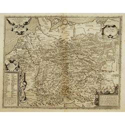
Braunsvicensis et Luneburgensis Ducatuum.
Early map of Brunswick and Lunenburg. Nice cartouche on the upper right corner.Abraham Ortelius (1527-1598) was a cartographer and publisher, who is born and died in Antw...
Date: Antwerp 1590
Selling price: ????
Please login to see price!
Sold
Zelandicarum Insularum Exactissima et Nova Descriptio.
From 'Theatrum Orbis Terrarum [Atlas of the Whole World]', Latin ed, pl. 39, CN no. 18.The Theatrum was re-issued in 42 editions with 5 supplements with text in Latin, Du...
Date: Antwerp 1590
Selling price: ????
Please login to see price!
Sold
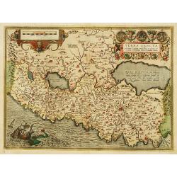
Terra Sancta.
This is the most modern of Ortelius' maps of the Holy Land. It focuses specifically on the Holy Land and is oriented with east of the top. Ortelius used as a model the wa...
Date: Antwerp 1590
Selling price: ????
Please login to see price!
Sold
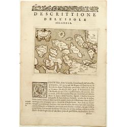
Isole Selandie.
In the stippled sea a compass-rose in the shape of a circular disc with indication of eight wind directions by means of the first letter of the Italian names: T, G, a Cro...
Date: Venise 1590
Selling price: ????
Please login to see price!
Sold
![De Ducatu Brabantino .. [Brabant]](/uploads/cache/13794-250x250.jpg)
De Ducatu Brabantino .. [Brabant]
On recto an early map of Brabant (Map : 94x135 mm). From a Latin text edition of his "Geographia", that great compendium of Renaissance knowledge.
Date: Bâle, 1550-1590
Selling price: ????
Please login to see price!
Sold
Caarte vanden .. Graefschappe van Hollandt..
Early map of Holland, engraved by Saenredam. Based on a map by Jacob van Deventer (1550). East is at the top. In the lower part, a typical 16th-century cartouche in Renai...
Date: Antwerp 1590
Selling price: ????
Please login to see price!
Sold
Natoliae..Aegypti recentior..Carthaginis (3 maps on 1 sheet)
3 Maps on one sheet. Map to the left east to the top. Detailed map Turkey, including Cyprus and Crete. Also map of the Nile delta and another map of Tunis.
Date: Antwerp 1590
Selling price: ????
Please login to see price!
Sold
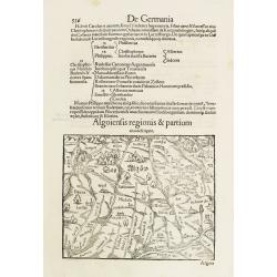
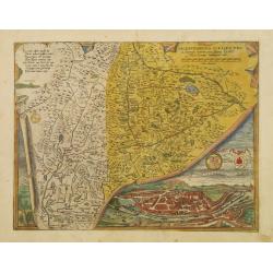
Algoiensis Regionis et Partium.
On recto an early map of the western part of Austria (127x155 mm).From a Latin text edition of his Geographia , that great compendium of Renaissance knowledge.
Date: Basle, 1550-1590
Selling price: ????
Please login to see price!
Sold in 2014
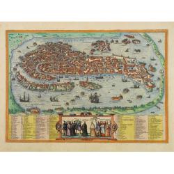
Venetia. (Venice)
Precise, beautiful bird's-eye view of Venice, clearly depicting the city's architectural landmark. The surrounding lagoon is animated with a great variety of sailing vess...
Date: Cologne 1590
Selling price: ????
Please login to see price!
Sold
Salisbvrgensis Ivrisdictionis, locorumgue vicinorum vera..
From Theatrum Orbis Terrarum [Atlas of the Whole World], published in Antwerp.The map is drawn in trompe l'oeil fashion, as though on a parchment of irregular shape, curl...
Date: Antwerp 1590
Selling price: ????
Please login to see price!
Sold
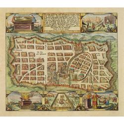
Waerachtige beschryvinge vande wydvermaerde Conincklicke Hooft Stadt Jerusalem..
Engraved by Baptista van Doetechum for a bible printed by Jan Everts Cloppenburg. The bible maps of 1590 are the earliest of Plancius compilations to survive.Very rare pl...
Date: Amsterdam, 1590
Selling price: ????
Please login to see price!
Sold in 2008
Abcontrafehtung der schönen und weitberümpten Statt Leon.
Map shows the city of Lyon wit a beautiful border.From a German text edition of his Cosmographia , that great compendium of Renaissance knowledge.
Date: Basle 1550-1590
Selling price: ????
Please login to see price!
Sold
Hispanie beschreibung mit seinen Künigreichen/landschafften und stätten/item von sitten/gebzeüchen der alten vn neüven Spaniern.
Map shows Spain with Portugal and the Island of Mallorca.From a German text edition of his Cosmographia , that great compendium of Renaissance knowledge.
Date: Basle 1550-1590
Selling price: ????
Please login to see price!
Sold
Anglia.
Map of Great Britain.From a German text edition of his Cosmographia , that great compendium of Renaissance knowledge.
Date: Basle 1550-1590
Selling price: ????
Please login to see price!
Sold
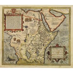
Presbiteri Iohannis, Sive, Abissin Orum Imperii Descriptio
Despite the title this map extends far beyond Prester John's supposed kingdom. It covers Africa from the fabled mountains of the moon in the center of the continent north...
Date: Antwerp 1590
Selling price: ????
Please login to see price!
Sold
![[Title page ] Galliae tabule geographicae. Per Gerardum Mercatorem..](/uploads/cache/61301-250x250.jpg)
[Title page ] Galliae tabule geographicae. Per Gerardum Mercatorem..
Very fine title page by Gerard Mercator, composed of an elaborate strapwork design with the portrait of a king at top.
Date: Duisburg, 1590
Selling price: ????
Please login to see price!
Sold in 2015
![[Map showing region of Basle and Strassbourg].](/uploads/cache/14377-250x250.jpg)
[Map showing region of Basle and Strassbourg].
An early map of Colmar, Strasbourg, Basle, etc. (85x135 cm). VERSO: showing the cultivation of vinesFrom a German text edition of his Geographia , that great compendium o...
Date: Basle 1550-1590
Selling price: ????
Please login to see price!
Sold
Cantuarbury.
A spectacular and early view of Canterbury.From the greatest publication in this genre! The Civitates was compiled and written by George Braun, Canon of Cologne Cathedral...
Date: Cologne 1590
Selling price: ????
Please login to see price!
Sold

Arcus ad d. Michaelis pars pior Hercules Prodicius.
Architectural frontage after design by P.P.Rubens. Engraved and published by Ta Thul.
Date: Antwerp c.1590
Selling price: ????
Please login to see price!
Sold
Tabula Geographica, in qua omnes regiones, urbes, oppida..
Engraved by Baptista van Doetechum for a bible by van Liesvelt. The bible maps of 1590 are the earliest of Plancius compilations to survive. Very rare map of Palestine di...
Date: Amsterdam 1590
Selling price: ????
Please login to see price!
Sold