Browse Listings

A New Map of the Kingdom of Prussia ...
A fine map by John Cary of Prussia.
Date: London, 1811
Selling price: ????
Please login to see price!
Sold in 2016
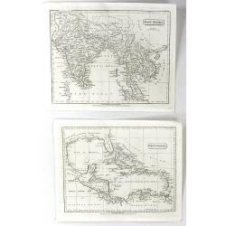
West Indies & East Indies (2 Maps)
Two separate maps published by Cadell & Davies in London in 1811. One is of the West Indies, and the other is of the East Indies. They were by John Pinkerton and are ...
Date: London, 1811
Selling price: ????
Please login to see price!
Sold in 2016
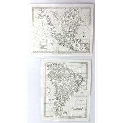
North America & South America (2 Maps)
Two separate maps published by Cadell & Davies in London in 1811. One is of North America, and the other is of South America. They are by John Pinkerton and from his ...
Date: London, 1811
Selling price: ????
Please login to see price!
Sold in 2016
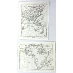
Africa & Asia (2 Maps)
Two separate maps published by Cadell & Davies in London in 1811. One is of Africa, and the other is of Asia. They are by John Pinkerton, and are from his atlas, the ...
Date: London, 1811
Selling price: ????
Please login to see price!
Sold in 2016
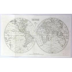
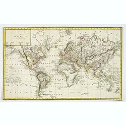
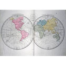
The World
A fine world map published by Cadell & Davies in London in 1811.It is by John Pinkerton, and from his atlas, the "MODERN GEOGRAPHY".
Date: London, 1811
Selling price: ????
Please login to see price!
Sold in 2016
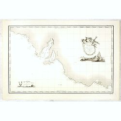
Carte Generale de la Terre Napoleon (a la Nouvelle Hollande)... par M.L. Freycinet an 1808
The rare issue of the "L'hydrographie française" with in the upper right corner "HYDR.FR N°636. No10".Important chart of part of Australia prepared ...
Date: Paris, after 1811
Selling price: ????
Please login to see price!
Sold in 2016
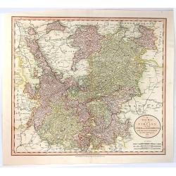
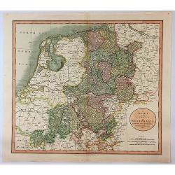
A New Map of the Circles of the Upper and Lower Rhine, from the Latest Authorities
A fine map of the Rhine region of Germany. Map covers from the Westphalia region south as far as France. Extends eastward as far as Luxemburg, and westward as far as Fran...
Date: London, 1811
Selling price: ????
Please login to see price!
Sold in 2016
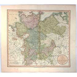
A New Map of the Circle of Lower Saxony, from the Latest Authorities.
A fine map of the Lower Saxony region of Germany. Map covers from the Holstein region south as far as Lower Rhine. Extends eastward as far as Westphalia and westward as ...
Date: London, 1811
Selling price: ????
Please login to see price!
Sold in 2016
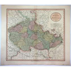
A New Map of Bohemia and Moravia from the Latest Authorities.
Attractive example of John Cary's 1811 map of Bohemia and Moravia. Covers the territory claimed by the modern day Czech Republic. Offers a great deal of detail and has p...
Date: London, 1811
Selling price: ????
Please login to see price!
Sold in 2017
A New Map of the Circle of Westphalia From the Latest Authorities.
An attractive example of John Cary's 1811 map of the Westphalia region of Germany. Map covers from the North Sea to the Lower Rhine, it also includes much of Holland, Bel...
Date: London, 1811
Selling price: ????
Please login to see price!
Sold in 2017
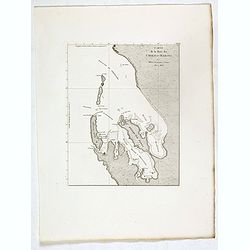
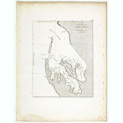
Carte de la Baie des Chiens-Marins par M. M. L. Freycinet et Faure, 1801 et 1803.
Map of Shark Bay in Western Australia, showing French discoveries prepared by Louis Freycinet during his voyage under Captain Thomas Baudin in 1800-1803. Plate no. 13 fro...
Date: Paris, Langois, 1811
Selling price: ????
Please login to see price!
Sold in 2017
![Plan des Iles Louis-Napoleon et de la Riviere des Cygnes (Terres de Leuwin et d'Edels) [cartographic material] / par M. M. L. Freycinet et Heirisson, ans 1801 et 1803.](/uploads/cache/39676-250x250.jpg)
Plan des Iles Louis-Napoleon et de la Riviere des Cygnes (Terres de Leuwin et d'Edels) [cartographic material] / par M. M. L. Freycinet et Heirisson, ans 1801 et 1803.
Map of Rottnest Island and the Swan River in Western Australia, showing French discoveries prepared by Louis Freycinet during his voyage under Captain Thomas Baudin in 18...
Date: Paris, Langois, 1811
Selling price: ????
Please login to see price!
Sold in 2017
![Plan de la Baie Laplace . . . [with] Esquisse du Port Western (a la Terre Napoleon, Nle. Hollande) . . .[with] Plan des Iles Forestier (a la Nouvelle-Hollande). . . [with] Esquisse du Port Champagny (a la Terre Napoleon) . . .](/uploads/cache/39677-250x250.jpg)
Plan de la Baie Laplace . . . [with] Esquisse du Port Western (a la Terre Napoleon, Nle. Hollande) . . .[with] Plan des Iles Forestier (a la Nouvelle-Hollande). . . [with] Esquisse du Port Champagny (a la Terre Napoleon) . . .
Four maps showing Tumby Bay and Port Lincoln in South Australia, Western Port in Victoria and Forestier Islands in Western Australia, showing French discoveries prepared ...
Date: Paris, Langois, 1811
Selling price: ????
Please login to see price!
Sold in 2017
![Plan du port du Roi-George, à la terre de Nuyts. . . [with] Plan de la baie du Geographe, à la terre de Leuwin. . .](/uploads/cache/39678-250x250.jpg)
Plan du port du Roi-George, à la terre de Nuyts. . . [with] Plan de la baie du Geographe, à la terre de Leuwin. . .
Two maps of King George Sound, Nuyts Land, showing French discoveries prepared by Louis Freycinet during his voyage under Captain Thomas Baudin in 1800-1803. Plate no. 10...
Date: Paris, Langois, 1811
Selling price: ????
Please login to see price!
Sold in 2017
![Plan des Iles Jerome (Terre Napoleon). . . [with] Plan des Iles Berthier (Terre Napoleon). . . [with] Plan du comte de Cumberland (Nouvelle-Galles du sud) d'apres les cartes Anglaises, mais assujetti aux observations Francaises.](/uploads/cache/39679-250x250.jpg)
Plan des Iles Jerome (Terre Napoleon). . . [with] Plan des Iles Berthier (Terre Napoleon). . . [with] Plan du comte de Cumberland (Nouvelle-Galles du sud) d'apres les cartes Anglaises, mais assujetti aux observations Francaises.
Three maps showing Dorothee Island and Veteran Isles in the Investigator Group and the County of Cumberland in New South Wales, showing French discoveries prepared by Lou...
Date: Paris, Langois, 1811
Selling price: ????
Please login to see price!
Sold in 2017
![Plan de l'Ile Decres (à la Terre Napoleon, Nouvelle-Hollande) par M. M. L. et H. Freycinet et Boullanger, 1802 et 1803. [with] Esquisse des Iles de l'Institut . . .](/uploads/cache/39680-250x250.jpg)
Plan de l'Ile Decres (à la Terre Napoleon, Nouvelle-Hollande) par M. M. L. et H. Freycinet et Boullanger, 1802 et 1803. [with] Esquisse des Iles de l'Institut . . .
Two maps showing Kangaroo Island in South Australia and Institut Islands in Western Australia, showing French discoveries prepared by Louis Freycinet during his voyage un...
Date: Paris, Langois, 1811
Selling price: ????
Please login to see price!
Sold in 2017
![Carte generale des Golfes Bonaparte et Josephine (a la Terre Napoleon, Nouvelle-Hollande) [cartographic material] / par M. M. L. Freycinet et Boullanger, 1803.](/uploads/cache/39681-250x250.jpg)
Carte generale des Golfes Bonaparte et Josephine (a la Terre Napoleon, Nouvelle-Hollande) [cartographic material] / par M. M. L. Freycinet et Boullanger, 1803.
Map showing Spencer Gulf and St. Vincent Gulf in South Australia showing French discoveries prepared by Louis Freycinet during his voyage under Captain Thomas Baudin in 1...
Date: Paris, Langois, 1811
Selling price: ????
Please login to see price!
Sold in 2017
![Plan d'une partie de la Terre Napoleon (Nouvelle-Hollande) par M. M. H. Freycinet et Bernier, an 1802. [with] Plan des Iles Josephine et de la Baie Murat (a la Terre Napoleon, Nouvelle-Hollande) . . .](/uploads/cache/39682-250x250.jpg)
Plan d'une partie de la Terre Napoleon (Nouvelle-Hollande) par M. M. H. Freycinet et Bernier, an 1802. [with] Plan des Iles Josephine et de la Baie Murat (a la Terre Napoleon, Nouvelle-Hollande) . . .
Two maps showing Descartes Bay and Bridgewater Bay in Victoria and Murat Bay in South Australia showing French discoveries prepared by Louis Freycinet during his voyage u...
Date: Paris, Langois, 1811
Selling price: ????
Please login to see price!
Sold in 2017
![Plan des Iles Hunter par M. M. Freycinet et Boullanger, an 1802. [with] Plan de l'Ile Maria par M. Boullanger, an 1802. [with] Plan de l'Ile King par M. Faure, an 1802. [with] Plan d'une partie de l'Archipel Bonaparte (a la Nouvelle-Hollande)](/uploads/cache/39683-250x250.jpg)
Plan des Iles Hunter par M. M. Freycinet et Boullanger, an 1802. [with] Plan de l'Ile Maria par M. Boullanger, an 1802. [with] Plan de l'Ile King par M. Faure, an 1802. [with] Plan d'une partie de l'Archipel Bonaparte (a la Nouvelle-Hollande)
Four maps showing Hunter Island in Bass Strait, Maria Island off the east coast of Tasmania, King Island in Bass Strait and Iles d'Arcole and Iles Champagny in the Bonapa...
Date: Paris, Langois, 1811
Selling price: ????
Please login to see price!
Sold in 2017
![Plan de la partie sud des Iles Furneaux d'apres le Capne. Flinders, en 1798, et assujetti ... [together with] Carte d'une partie de la cote orientale de la terre de Diemen / par M. M. Boullanger et Faure en 1802.](/uploads/cache/39684-250x250.jpg)
Plan de la partie sud des Iles Furneaux d'apres le Capne. Flinders, en 1798, et assujetti ... [together with] Carte d'une partie de la cote orientale de la terre de Diemen / par M. M. Boullanger et Faure en 1802.
Maps showing the southern coastline of Cape Barren Island and Clarke Island in the southern part of the Furneaux Group and the northeastern coastline of Tasmania from Por...
Date: Paris, Langois, 1811
Selling price: ????
Please login to see price!
Sold in 2017
![Carte generale de la partie sud-est de la Terre de Diemen [cartographic material] / d'apres les travaux de M. M. Beautemps-Beaupre, en 1792 et 1793, L. et H. Freycinet, Boullanger et Faure en 1802.](/uploads/cache/39685-250x250.jpg)
Carte generale de la partie sud-est de la Terre de Diemen [cartographic material] / d'apres les travaux de M. M. Beautemps-Beaupre, en 1792 et 1793, L. et H. Freycinet, Boullanger et Faure en 1802.
Map of the south eastern coastline of Tasmania from Point Bailly to Recherche Bay showing French discoveries prepared by Louis Freycinet during his voyage under Captain T...
Date: Paris, Langois, 1811
Selling price: ????
Please login to see price!
Sold in 2017
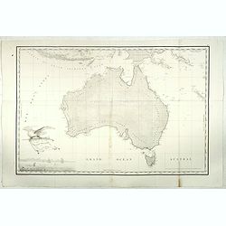
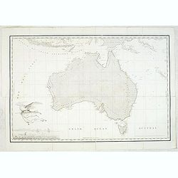
Carte Generale de la Nouvelle Hollande.
Fine map of the continent of Australia prepared by Louis Freycinet during his voyage under Captain Thomas Baudin in 1800-1803. Freycinet's map of New Holland was the firs...
Date: Paris, 1811
Selling price: ????
Please login to see price!
Sold in 2017
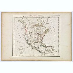
Amérique septentrionale.
A fine map of North America published by the well-known Paris publisher of maps, globes and atlases C.F. Delamarche.
Date: Paris, 1811
Selling price: ????
Please login to see price!
Sold in 2017
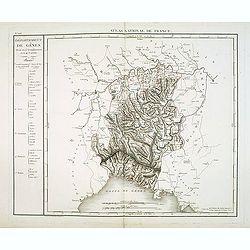
Département de Gênes Divisé en 5 Arrondissemens et en 41 cantons.
Published in the "Atlas National de France" at Chanlaire. Engraved by P.A.F. Tardieu. Represents the department of Genoa which was under French administration b...
Date: Paris, 1790-1811
Selling price: ????
Please login to see price!
Sold in 2018
The World on Mercator's Projection.
"The World on Mercator's Projection" engraved by Cooper after Alex MacPherson, published in A System of Modern Geography, in 1811. Copper engraved antique map w...
Date: London, ca 1811
Selling price: ????
Please login to see price!
Sold in 2020
![Carte generale de la partie sud-est de la Terre de Diemen [cartographic material] / d'apres les travaux de M. M. Beautemps-Beaupre, en 1792 et 1793, L. et H. Freycinet, Boullanger et Faure en 1802.](/uploads/cache/44028-250x250.jpg)
Carte generale de la partie sud-est de la Terre de Diemen [cartographic material] / d'apres les travaux de M. M. Beautemps-Beaupre, en 1792 et 1793, L. et H. Freycinet, Boullanger et Faure en 1802.
Map of the south eastern coastline of Tasmania from Point Bailly to Recherche Bay showing French discoveries prepared by Louis Freycinet during his voyage under Captain T...
Date: Paris, Langois, 1811
Selling price: ????
Please login to see price!
Sold in 2019
![Plan de la partie sud des Iles Furneaux d'apres le Capne. Flinders, en 1798, et assujetti ... [together with] Carte d'une partie de la cote orientale de la terre de Diemen / par M. M. Boullanger et Faure en 1802.](/uploads/cache/44029-250x250.jpg)
Plan de la partie sud des Iles Furneaux d'apres le Capne. Flinders, en 1798, et assujetti ... [together with] Carte d'une partie de la cote orientale de la terre de Diemen / par M. M. Boullanger et Faure en 1802.
Maps showing the southern coastline of Cape Barren Island and Clarke Island in the southern part of the Furneaux Group and the north-eastern coastline of Tasmania from Po...
Date: Paris, Langois, 1811
Selling price: ????
Please login to see price!
Sold in 2019
![Plan des Iles Hunter par M. M. Freycinet et Boullanger, an 1802. [with] Plan de l'Ile Maria par M. Boullanger, an 1802. [with] Plan de l'Ile King par M. Faure, an 1802. [with] Plan d'une partie de l'Archipel Bonaparte (a la Nouvelle-Hollande)](/uploads/cache/44030-250x250.jpg)
Plan des Iles Hunter par M. M. Freycinet et Boullanger, an 1802. [with] Plan de l'Ile Maria par M. Boullanger, an 1802. [with] Plan de l'Ile King par M. Faure, an 1802. [with] Plan d'une partie de l'Archipel Bonaparte (a la Nouvelle-Hollande)
Four maps showing Hunter Island in Bass Strait, Maria Island off the east coast of Tasmania, King Island in Bass Strait and Iles d'Arcole and Iles Champagny in the Bonapa...
Date: Paris, Langois, 1811
Selling price: ????
Please login to see price!
Sold in 2019
![Plan d'une partie de la Terre Napoleon (Nouvelle-Hollande) par M. M. H. Freycinet et Bernier, an 1802. [with] Plan des Iles Josephine et de la Baie Murat (a la Terre Napoleon, Nouvelle-Hollande) . . .](/uploads/cache/44031-250x250.jpg)
Plan d'une partie de la Terre Napoleon (Nouvelle-Hollande) par M. M. H. Freycinet et Bernier, an 1802. [with] Plan des Iles Josephine et de la Baie Murat (a la Terre Napoleon, Nouvelle-Hollande) . . .
Two maps showing Descartes Bay and Bridgewater Bay in Victoria and Murat Bay in South Australia showing French discoveries prepared by Louis Freycinet during his voyage u...
Date: Paris, Langois, 1811
Selling price: ????
Please login to see price!
Sold in 2019
![Carte generale des Golfes Bonaparte et Josephine (a la Terre Napoleon, Nouvelle-Hollande) [cartographic material] / par M. M. L. Freycinet et Boullanger, 1803.](/uploads/cache/44032-250x250.jpg)
Carte generale des Golfes Bonaparte et Josephine (a la Terre Napoleon, Nouvelle-Hollande) [cartographic material] / par M. M. L. Freycinet et Boullanger, 1803.
Map showing Spencer Gulf and St. Vincent Gulf in South Australia showing French discoveries prepared by Louis Freycinet during his voyage under Captain Thomas Baudin in 1...
Date: Paris, Langois, 1811
Selling price: ????
Please login to see price!
Sold in 2019
![Plan de l'Ile Decres (à la Terre Napoleon, Nouvelle-Hollande) par M. M. L. et H. Freycinet et Boullanger, 1802 et 1803. [with] Esquisse des Iles de l'Institut . . .](/uploads/cache/44033-250x250.jpg)
Plan de l'Ile Decres (à la Terre Napoleon, Nouvelle-Hollande) par M. M. L. et H. Freycinet et Boullanger, 1802 et 1803. [with] Esquisse des Iles de l'Institut . . .
Two maps showing Kangaroo Island in South Australia and Institut Islands in Western Australia, showing French discoveries prepared by Louis Freycinet during his voyage un...
Date: Paris, Langois, 1811
Selling price: ????
Please login to see price!
Sold in 2019
![Plan des Iles Jerome (Terre Napoleon). . . [with] Plan des Iles Berthier (Terre Napoleon). . . [with] Plan du comte de Cumberland (Nouvelle-Galles du sud) d'apres les cartes Anglaises, mais assujetti aux observations Francaises.](/uploads/cache/44034-250x250.jpg)
Plan des Iles Jerome (Terre Napoleon). . . [with] Plan des Iles Berthier (Terre Napoleon). . . [with] Plan du comte de Cumberland (Nouvelle-Galles du sud) d'apres les cartes Anglaises, mais assujetti aux observations Francaises.
Three maps showing Dorothee Island and Veteran Isles in the Investigator Group and the County of Cumberland in New South Wales, showing French discoveries prepared by Lou...
Date: Paris, Langois, 1811
Selling price: ????
Please login to see price!
Sold in 2019
![Plan du port du Roi-George, à la terre de Nuyts. . . [with] Plan de la baie du Geographe, à la terre de Leuwin. . .](/uploads/cache/44035-250x250.jpg)
Plan du port du Roi-George, à la terre de Nuyts. . . [with] Plan de la baie du Geographe, à la terre de Leuwin. . .
Two maps of King George Sound, Nuyts Land, showing French discoveries prepared by Louis Freycinet during his voyage under Captain Thomas Baudin in 1800-1803. Plate no. 10...
Date: Paris, Langois, 1811
Selling price: ????
Please login to see price!
Sold in 2019
![Plan de la Baie Laplace . . . [with] Esquisse du Port Western (a la Terre Napoleon, Nle. Hollande) . . .[with] Plan des Iles Forestier (a la Nouvelle-Hollande). . . [with] Esquisse du Port Champagny (a la Terre Napoleon) . . .](/uploads/cache/44036-250x250.jpg)
Plan de la Baie Laplace . . . [with] Esquisse du Port Western (a la Terre Napoleon, Nle. Hollande) . . .[with] Plan des Iles Forestier (a la Nouvelle-Hollande). . . [with] Esquisse du Port Champagny (a la Terre Napoleon) . . .
Four maps showing Tumby Bay and Port Lincoln in South Australia, Western Port in Victoria and Forestier Islands in Western Australia, showing French discoveries prepared ...
Date: Paris, Langois, 1811
Selling price: ????
Please login to see price!
Sold in 2021
![Plan des Iles Louis-Napoleon et de la Riviere des Cygnes (Terres de Leuwin et d'Edels) [cartographic material] / par M. M. L. Freycinet et Heirisson, ans 1801 et 1803.](/uploads/cache/44037-250x250.jpg)
Plan des Iles Louis-Napoleon et de la Riviere des Cygnes (Terres de Leuwin et d'Edels) [cartographic material] / par M. M. L. Freycinet et Heirisson, ans 1801 et 1803.
Map of Rottnest Island and the Swan River in Western Australia, showing French discoveries prepared by Louis Freycinet during his voyage under Captain Thomas Baudin in 18...
Date: Paris, Langois, 1811
Selling price: ????
Please login to see price!
Sold in 2019
Carte de la Baie des Chiens-Marins par M. M. L. Freycinet et Faure, 1801 et 1803.
Map of Shark Bay in Western Australia, showing French discoveries prepared by Louis Freycinet during his voyage under Captain Thomas Baudin in 1800-1803. Plate no. 13 fro...
Date: Paris, Langois, 1811
Selling price: ????
Please login to see price!
Sold in 2020
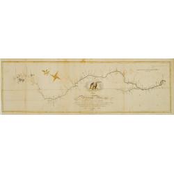
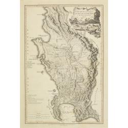
Map of the Mississippi River from its source to the mouth of the Missouri..
Very rare map, one of the first maps of the Mississippi River with its tributaries, giving latitude and longitude markings along the way. Prepared during Zebulon Montgome...
Date: Baltimore 1811
Selling price: ????
Please login to see price!
Sold
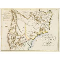
Map of the interior of Louisiana with part of New Mexico..
Engraved by Haase. A mile stone map of the internal part of Louisiana, including the Mississippi in the East and the Mountains of Mexico in the West: with a part of New M...
Date: London 1811
Selling price: ????
Please login to see price!
Sold
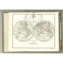
Petit Atlas moderne ou collection de cartes élémentaires dédié à la jeunesse.
Charming pocket atlas with decorative engraved title page, 2 plates with spheres, world map in double hemisphere, Europe, France (2), The Low Countries, Spain, Italy, Ger...
Date: Paris, chez Delamarche, s.d.circa 1811
Selling price: ????
Please login to see price!
Sold

A new map of the East India Islands from the latest authorities. . .
Detailed map of the Indonesia , including the Malay Peninsula, engraved and published by John Cary. With excellent and geographically depicted detail. The original hand c...
Date: London, 1811
Selling price: ????
Please login to see price!
Sold in 2011
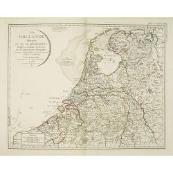
La hollande divisée en ses IX. Départemens d'apres sa réunion a la France, avec les départemens limitrophes. . .
Very interesting map of the present-day Netherlands shown in 1811. During the period 1810 to 1813 the Low Countries were annexed by Napoleon to the French Empire and actu...
Date: Paris, 1811
Selling price: ????
Please login to see price!
Sold in 2010
The Dutch colony of the Cape of Good Hope / by L.S. De La Rochette.
Uncommon detailed map of the Cape of Good Hope, showing kraals or villages, fountains, river crossings, early settlers, anchorages, etc. Prepared by Louis Stanislas d'Arc...
Date: London, 1795-1811
Selling price: ????
Please login to see price!
Sold in 2010
A complete course of Geography, by means of instructive games...
Interesting Atlas with 14 double-page engraved maps by Mr. Wauthier after the Abbé Gaultier and dated 1797 or 1799. First with 50 pages of text about Geography, then t...
Date: London, 1811
Selling price: ????
Please login to see price!
Sold in 2015
Carte Generale de la Nouvelle Hollande.
Fine map of the continent of Australia prepared by Louis Freycinet during his voyage under Captain Thomas Baudin in 1800-1803. Freycinet's map of New Holland was the firs...
Date: Paris, 1811
Selling price: ????
Please login to see price!
Sold in 2011
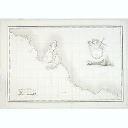
Carte Generale de la Terre Napoleon (a la Nouvelle Hollande)... par M.L. Freycinet an 1808
Fine map of part of Australia prepared by Louis Freycinet during his voyage under Captain Thomas Baudin in 1800-1803. The longitude is calculated from Paris.The cartouche...
Date: Paris, 1811
Selling price: ????
Please login to see price!
Sold in 2011

Charte von China und den angränzenden Ländern und Völkerschaften so wie den letzten Kaiser Tschien-Long. . .
Uncommon map of China on a scale of ca. 1:6,000,000. The map's complete title is “Charte von China und den angränzenden Ländern, und Völkerschaften so wie sie dem le...
Date: Parague, 1812
Selling price: ????
Please login to see price!
Sold in 2023
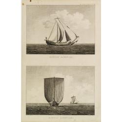
Bateau Japonais. Two prints on one sheet.
Engraving of 18th century Japanese boat drawn by Lt. Blondela. Done during the expedition of comte de Jean-Francois de Galaup La Perouse in the Pacific Ocean in 1785-1788...
Date: Paris, 1812
Selling price: ????
Please login to see price!
Sold in 2023
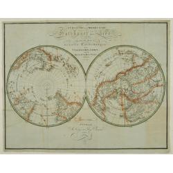
Südliche und Noerdliche Halbkugel der Erde..
Detailed map of the north and south pole projections in double hemisphere, prepared by Friedrich Carl Ludwig Sickler (1773-1836). Printed at the "Geographische Insti...
Date: Weimar 1812
Selling price: ????
Please login to see price!
Sold
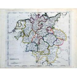
Germany.
A simple, yet elegant, map of Germany by M. Carey done in the early 19th century.
Date: Philadelphia, 1812
Selling price: ????
Please login to see price!
Sold in 2010
Geographiske chartor öfver Swerige. Afd. I-IV. 1796-1812.
This is the beautiful first four parts of Samuel Gustav Hermelins atlas of Sweden and Finland "Geografiske Kartor öfver Swerige". Each of the four title pages ...
Date: Stockholm, 1796-1812
Selling price: ????
Please login to see price!
Sold
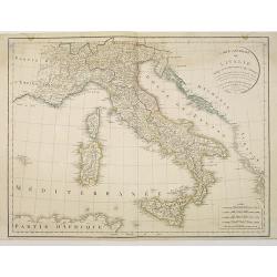
Carte générale de l'Italie rédigée sur les observations les plus authentiques. . .
Map showing Italy and the islands of Corsica, Sardinia and Sicily.
Date: Paris, 1812
Selling price: ????
Please login to see price!
Sold in 2010
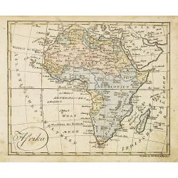
Afrika.
Nice small map of Africa published by Johannes Walch in his rare Allgemeiner Atlas Nach den bewährsten Hülfsmitteln und astronomischen Ortsbestimungen..., edition of 18...
Date: Augsburg, 1812
Selling price: ????
Please login to see price!
Sold in 2013
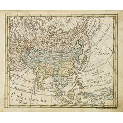
Asien.
Nice small map of Asia published by Johannes Walch in his rare Allgemeiner Atlas Nach den bewährsten Hülfsmitteln und astronomischen Ortsbestimungen…, edition of 1812...
Date: Augsburg, 1812
Selling price: ????
Please login to see price!
Sold in 2018
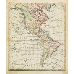
Amerika.
Nice small map of America published by Johannes Walch in his rare Allgemeiner Atlas Nach den bewährsten Hülfsmitteln und astronomischen Ortsbestimungen…, edition of 1...
Date: Augsburg, 1812
Selling price: ????
Please login to see price!
Sold in 2022
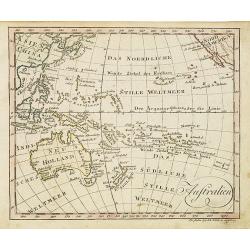
Australia.
Nice small map centered on Australia and New Zealand published by Johannes Walch in his rare Allgemeiner Atlas Nach den bewährsten Hülfsmitteln und astronomischen Ortsb...
Date: Augsburg, 1812
Selling price: ????
Please login to see price!
Sold in 2016
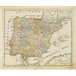
Spanien und Portugal.
Nice small map of Spain and Portugal published by Johannes Walch in his rare Allgemeiner Atlas Nach den bewährsten Hülfsmitteln und astronomischen Ortsbestimungen…, e...
Date: Augsburg, 1812
Selling price: ????
Please login to see price!
Sold in 2023
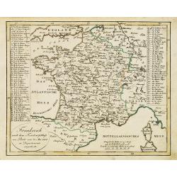
Frankreich nach dem Friedensschluss. . .
Nice small map of France published by Johannes Walch in his rare Allgemeiner Atlas Nach den bewährsten Hülfsmitteln und astronomischen Ortsbestimungen…, edition of 18...
Date: Augsburg, 1812
Selling price: ????
Please login to see price!
Sold
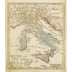
Italien.
Nice small map of Italy by Johannes Walch in his rare Allgemeiner Atlas Nach den bewährsten Hülfsmitteln und astronomischen Ortsbestimungen…, edition of 1812.Johann W...
Date: Augsburg, 1812
Selling price: ????
Please login to see price!
Sold in 2023
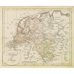
Holland und Berg.
Nice small map of The northern part of The Netherlands and part of Germany by Johannes Walch in his rare Allgemeiner Atlas Nach den bewährsten Hülfsmitteln und astronom...
Date: Augsburg, 1812
Selling price: ????
Please login to see price!
Sold in 2019
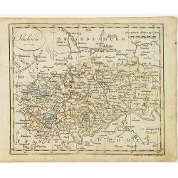
Sachsen.
Nice small map of Saxe in Germany by Johannes Walch in his rare Allgemeiner Atlas Nach den bewährsten Hülfsmitteln und astronomischen Ortsbestimungen…, edition of 181...
Date: Augsburg, 1812
Selling price: ????
Please login to see price!
Sold in 2017
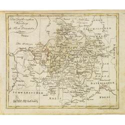
Das Grossherzogthum Würzburg, und die Fûrst Primatischen Staaten.
Nice small map of Wurzburg in Southern Germany by Johannes Walch in his rare Allgemeiner Atlas Nach den bewährsten Hülfsmitteln und astronomischen Ortsbestimungen…, e...
Date: Augsburg, 1812
Selling price: ????
Please login to see price!
Sold in 2018
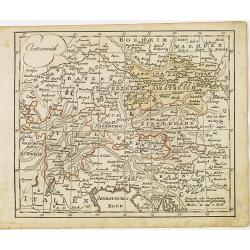
Oesterreich.
Nice small map of Austria by Johannes Walch in his rare Allgemeiner Atlas Nach den bewährsten Hülfsmitteln und astronomischen Ortsbestimungen…, edition of 1812.Johann...
Date: Augsburg, 1812
Selling price: ????
Please login to see price!
Sold in 2015
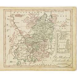
Der Oberrheinische u. Churrheinische Kreis.
Nice small map centered on Frankfurt in Eastern part of Germany by Johannes Walch in his rare Allgemeiner Atlas Nach den bewährsten Hülfsmitteln und astronomischen Orts...
Date: Augsburg, 1812
Selling price: ????
Please login to see price!
Sold in 2020
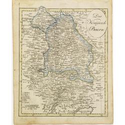
Das Königreich Baiern.
Nice small map of Bayern in Southern Germany by Johannes Walch in his rare Allgemeiner Atlas Nach den bewährsten Hülfsmitteln und astronomischen Ortsbestimungen…, edi...
Date: Augsburg, 1812
Selling price: ????
Please login to see price!
Sold in 2015
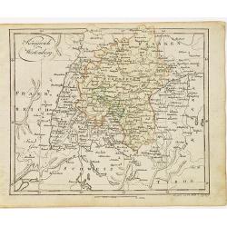
Königreich Wirtemberg.
Nice small map of Wirtemberg in Southern Germany by Johannes Walch in his rare Allgemeiner Atlas Nach den bewährsten Hülfsmitteln und astronomischen Ortsbestimungen…,...
Date: Augsburg, 1812
Selling price: ????
Please login to see price!
Sold in 2017
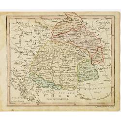
Ungarn und Galizien.
Nice small map of Hungary by Johannes Walch in his rare Allgemeiner Atlas Nach den bewährsten Hülfsmitteln und astronomischen Ortsbestimungen…, edition of 1812.Johann...
Date: Augsburg, 1812
Selling price: ????
Please login to see price!
Sold in 2010
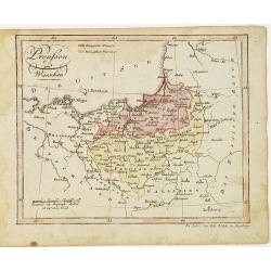
Preussen und Warschau.
Nice small map of Prussia by Johannes Walch in his rare Allgemeiner Atlas Nach den bewährsten Hülfsmitteln und astronomischen Ortsbestimungen…, edition of 1812.Johann...
Date: Augsburg, 1812
Selling price: ????
Please login to see price!
Sold in 2012
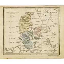
Daenemark.
Nice small map of Denmark by Johannes Walch in his rare Allgemeiner Atlas Nach den bewährsten Hülfsmitteln und astronomischen Ortsbestimungen…, edition of 1812.Johann...
Date: Augsburg, 1812
Selling price: ????
Please login to see price!
Sold in 2012
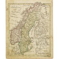
Schweden und Norwegen.
Nice small map of Scandinavia by Johannes Walch in his rare Allgemeiner Atlas Nach den bewährsten Hülfsmitteln und astronomischen Ortsbestimungen…, edition of 1812.Jo...
Date: Augsburg, 1812
Selling price: ????
Please login to see price!
Sold in 2012
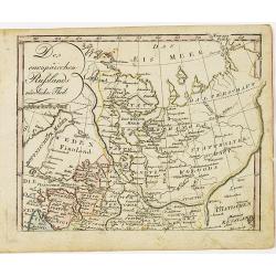
Des europäischen Ruslands nördlicher Theil.
Nice small map of European part of Russia by Johannes Walch in his rare Allgemeiner Atlas Nach den bewährsten Hülfsmitteln und astronomischen Ortsbestimungen…, editio...
Date: Augsburg, 1812
Selling price: ????
Please login to see price!
Sold in 2010
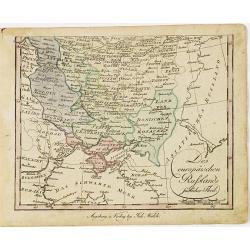
Des europäischen Ruslands südlicher Theil.
Nice small map of the South European part of Russia, including Crimea by Johannes Walch in his rare Allgemeiner Atlas Nach den bewährsten Hülfsmitteln und astronomische...
Date: Augsburg, 1812
Selling price: ????
Please login to see price!
Sold in 2010
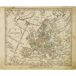
Europa.
Nice small map of Europe by Johannes Walch in his rare Allgemeiner Atlas Nach den bewährsten Hülfsmitteln und astronomischen Ortsbestimungen…, edition of 1812.Johann ...
Date: Augsburg, 1812
Selling price: ????
Please login to see price!
Sold in 2015
![[No Tittle] Sud pol.](/uploads/cache/29382-250x250.jpg)
[No Tittle] Sud pol.
Nice small map of South pole, including Australia and New Zealand by Johannes Walch in his rare Allgemeiner Atlas Nach den bewährsten Hülfsmitteln und astronomischen Or...
Date: Augsburg, 1812
Selling price: ????
Please login to see price!
Sold in 2022
![[No Tittle] Nord pole map.](/uploads/cache/29383-250x250.jpg)
[No Tittle] Nord pole map.
Nice small map of North pole by Johannes Walch in his rare Allgemeiner Atlas Nach den bewährsten Hülfsmitteln und astronomischen Ortsbestimungen…, edition of 1812.Joh...
Date: Augsburg, 1812
Selling price: ????
Please login to see price!
Sold in 2015
![[No Tittle] Map of the west of world.](/uploads/cache/29384-250x250.jpg)
[No Tittle] Map of the west of world.
Nice small map of the continent of America by Johannes Walch in his rare Allgemeiner Atlas Nach den bewährsten Hülfsmitteln und astronomischen Ortsbestimungen…, editi...
Date: Augsburg, 1812
Selling price: ????
Please login to see price!
Sold in 2015
![[Title page] Allgemeiner Atlas Nach den bewährsten Hülfsmitteln und astronomischen Ortsbestimungen](/uploads/cache/29407-250x250.jpg)
[Title page] Allgemeiner Atlas Nach den bewährsten Hülfsmitteln und astronomischen Ortsbestimungen
Title page by Johannes Walch from his rare Allgemeiner Atlas Nach den bewährsten Hülfsmitteln und astronomischen Ortsbestimungen…, edition of 1812.Johann Walch (1757-...
Date: Augsburg, 1812
Selling price: ????
Please login to see price!
Sold in 2017
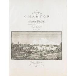
Plan de Polotsk.
Map of Polotsk at the river Dvina in Belarus.
Date: Hyères, 1812
Selling price: ????
Please login to see price!
Sold in 2010
![[No title - on manuscript label : Carte Russe des routes de poste. . . Carte pour la campagne de russie de 1812.]](/uploads/cache/30620-250x250.jpg)
[No title - on manuscript label : Carte Russe des routes de poste. . . Carte pour la campagne de russie de 1812.]
A post road maps map of west of Russia. Map showing the region of North of Moscow and including Saint Petersburg.The map is part of a larger map, and this section has no ...
Date: France, ca. 1812
Selling price: ????
Please login to see price!
Sold in 2011
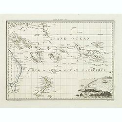
Océanique orient.
In lower right hand corner a view of sailor. An steel engraved map showing part of the east coast of Australia with Torres Strait to Tasmania., the Marquesas, the Carolin...
Date: Paris, 1812
Selling price: ????
Please login to see price!
Sold in 2022
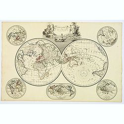
Mappe-Mondes sur Diverses Projections.
An attractive double page double-hemisphere world map with inset projections and very decorative cartouche, from the 'Atlas Supplementaire du Precis de la Geographie Univ...
Date: Paris, 1812
Selling price: ????
Please login to see price!
Sold in 2020