Subscribe to be notified if similar examples become available.
Geographiske chartor öfver Swerige. Afd. I-IV. 1796-1812. |
||||||||||||||||||||
|
||||||||||||||||||||
|
|
||||||||||||||||||||
|
|
My Collection + - Save and collect this or any of your favorite items in one place.
If you want to save the items permanently, please sign in or create account first. |
|||||||||||||||||||
Description
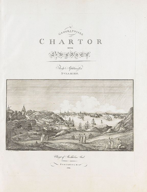
This is the beautiful first four parts of Samuel Gustav Hermelins atlas of Sweden and Finland "Geografiske Kartor öfver Swerige". Each of the four title pages have spectacular landscape images or a view of Stockholm, engraved by Fredrik Akrel, a very skilled and productive engraver who later became director of Anders åkermans globe construction shop.
Hermelins atlas was the first comprehensive mapping of Sweden and Finland. An earlier attempt by "Kongl. Landtmäteri Contoiret" in the 18th century, did not manage to cover the entire country.
Samuel Gustav Hermelin launched his major cartographic undertaking as a private citizen. Unfortunately he suffered substantial economic loss. Due to economic difficulties the work, in its later stages, was continued by "Geographisk Inrättning", a private company before the government bought the plates, and the rights, to the work in the 1820s.
The atlas was published 1796-1818. The Finnish part of the atlas was produced a few years before Sweden lost Finland to Russia.
Hermelin (Samuel Gustaf, Baron) was a Swedish cartographer, mineralogist and patriot, born on 4 April 1744 and died in Stockholm on 4 March 1820. He made explorations (1782-1784) in Germany, France, in North America and the British Isles, and on his return he introduced his improvements in the exploitation of mines in Falun. He was quit successful and established factories, sawmills, settled in Norrbotten, brought dry marsh, he build roads and discovered the rich mines Gellivare. He prepare maps and published an "Atlas of Sweden and the Finland (1797-1807)", unfortunately the project failed and only 58 maps were published.
Imperial folio. Graverat huvudtitelblad m. innehållsförteckning (ngt fläckad), 4 graverade deltitelblad. M. vignetter, 28 samtida delvis kolorerade graverade kartor på 30 blad.
Något nött brunt senare (tidigt 1900-tal) hfrbd, marmorerade pärmpapper, guldorn. Rygg.
Följande finns (där ej annat anmärks är kartorna i gott skick, flera med breda marginaler, några är dock vikta, enstaka fläckar ej anmärkta).
Graverat huvudtlbl. Till första delen (daterat 1805, enstaka fläckar, tar inte upp Göta Rike).
Avd. I. .Graverat deltitelblad m. vignette (1797, för norra landsorter), Swerige (1797), Wästerbottn och Svenske Lappmarcken (1796, liten fläck), Ångermanland, Medelpad och Jämtland (1797), Herjeådalen (1797), Gästrikland och Hellsingland (1796).
Avd. II: Graverat deltitelblad m. vignette (1799, för Finland, fuktfläckad i övre yttre höger hörn), Finland (1799,, Uleåborgs höfdingedöme (1798), Wasa höfdingedöme (1798), Åbo och Björneborgs höfdingedöme (1799, något brunfläckad), Nylands och Tavastehus samt Kymmenegårds höfdingedöme (1798), Savolax och Karelen eller Kuopio höfdingedöme (u.å., ngt brunfläckad).Avd. III. Graverat deltitelblad m. vignette (1801, för Svea Rike, vignetten Stockholmsvy av J. F. Martin), Stora Kopparberg (1800), Kopparbergs, Säter, Näsgårds och Wästra Bergslagen (1800), Wästerås höfdingedöme (1800), Upsala höfdingedöme (1801, lagad reva i inre marginal, brunfläckad i övre deloch övre del av yttre marginal), Stockholms höfdingedöme (1802, längre lagad reva i nedre marginal, ngt fläckad), Örebro höfdingedöme (1803, delvis brunfläckad), Nyköpings höfdingedöme (1804, brunfläckad).
Avd. IV: Graverat deltitelblad m. vignette (1807, för Götarike, brunfläckad, förlängd yttermarginal). Götarike (1807, brunfläckad). Carlstads höfdingedöme eller Wermeland (1808, i 2 delar). Göteborgs och Bohus län (1806). Elfsborgs höfdingedöme (1808, liten reva i nedre marginal). Skaraborgs höfdingedöme (1807, nära skuren i övre o. nedre marginal, en del lagade revor o. förstärkningar i marginalerna). Östergötland (1810, ngt nött i vänster marginal, smala marginaler). Halmstads höfdingedöme eller Halland (1807, något veck, några småfläckar). Jönköpings, Kronobergs och Bleking höfdingedömen (1809, skuren i marginalerna, mindre reva). Gotland (1805, nött i marginalerna). Skåne (1812, 2 blad, norra delen loss och itu).
Extra shipping costs apply, the atlas wioll be shipped at nominal fees, please inform.)
FAQ - Guarantee - Shipping
Buying in the BuyNow Gallery
This item is available for immediate purchase when a "Add to Cart" or "Inquire Now" button is shown.
Items are sold in the EU margin scheme
Payments are accepted in Euros or US Dollars.
Authenticity Guarantee
 We provide professional descriptions, condition report (based on 45 years experience in the map business)
Paulus Swaen warrants the authenticity of our items and a certificate of authenticity is provided for each acquired lot.
Condition and Coloring
We indicate the condition of each item and use our unnique HiBCoR grading system in which four key items determine a map's value: Historical Importance, Beauty, Condition/Coloring and Rarity.
Color Key
We offer many maps in their original black and white condition. We do not systematically color-up maps to make them more sellable to the general public or buyer.
Copper engraved or wood block maps are always hand colored. Maps were initially colored for aesthetic reasons and to improve readability. Nowadays, it is becoming a challenge to find maps in their original colors and are therefor more valuable.
We use the following color keys in our catalog:
Original colors; mean that the colors have been applied around the time the map was issued.
Original o/l colors; means the map has only the borders colored at the time of publication.
Colored; If the colors are applied recently or at the end of the 20th century.
Read more about coloring of maps [+]
Shipping fee
A flat shipping fee of $ 30 is added to each shipment by DHL within Europe and North America. This covers : International Priority shipping, Packing and Insurance (up to the invoice amount).
Shipments to Asia are $ 40 and rest of the world $50
We charge only one shipping fee when you have been successful on multiple items or when you want to combine gallery and auction purchases.
Read more about invoicing and shipping
FAQ
Please have a look for more information about buying in the BuyNow gallery
Many answers are likely to find in the general help section.
My Collection+
![]()
With My Collection+ you can collect all your favorite items in one place. It is free, and anyone can create his or her virtual collection.
Unless you are logged in, the item is only saved for this session. You have to be registed and logged-in if you want to save this item permanently to My Collection+.
Read More[+]
Register here, it is free and you do not need a credit card.
Add this item to
My Collection+
or click the following link to see My Collection+.
| Digital Image Download | |
|
Paulus Swaen maintains an archive of most of our high-resolution rare maps, prints, posters and medieval manuscript scans. We make them freely available for download and study. Read more about free image download |
Click the image for a free small image download. |
In accordance with the EU Consumer Rights Directive and habitually reside in the European Union you have the right to cancel the contract for the purchase of a lot, without giving any reason.
The cancellation period will expire 14 calendar days from the day after the date on which you or a third party (other than the carrier and indicated by you) acquires, physical possession of the lot. To exercise the right to cancel you must inform Paulus Swaen Inc, of your decision to cancel this contract by a clear statement (e.g. a letter sent by post, or e-mail (amsterdam@swaen.com).
To meet the cancellation deadline, it is sufficient for you to send your communication concerning your exercise of the right to cancel before the cancellation period has expired.
