Browse Listings

The plantain tree, in the island of Cracatoa.
The plantain tree, in the island of Cracatoa, taken from "Views in the South Seas" being a very important and early views depicting scenes encountered while emp...
Date: London, Boydell and Co., 1808
Selling price: ????
Please login to see price!
Sold in 2010
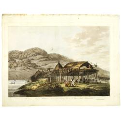
Balagans or summer habitations, with the method of drying fish at St. Peter and Paul, Kamtschatka.
Balagans or summer habitations, with the method of drying fish at St. Peter and Paul, Kamtschatka, taken from "Views in the South Seas" being a very important a...
Date: London, Boydell and Co., 1808
Selling price: ????
Please login to see price!
Sold in 2017
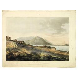
View in Macao, including the residence of camoens, when he wrote his Lusiad.
One of two views of Macao, taken from "Views in the South Seas" being a very important and early views depicting scenes encountered while employed as draughtsma...
Date: London, Boydell and Co., 1808
Selling price: ????
Please login to see price!
Sold in 2010
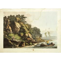
View in Macao.
Early view of Macao, taken from "Views in the South Seas" being a very important and early views depicting scenes encountered while employed as draughtsman on C...
Date: London, Boydell and Co., 1808
Selling price: ????
Please login to see price!
Sold in 2012
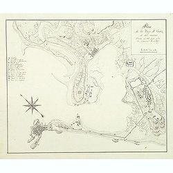
Plan de la baye de Cadiz et des environs Dressé en 1808 par ordre de l'amiral Rosillef
Anonymous pen and ink drawing with a lettered key (A-O) in left part. The Capture of the Rosily Squadron took place on 14 June 1808, in Cadiz, Spain, nearly three years a...
Date: ca. 1808
Selling price: ????
Please login to see price!
Sold in 2011
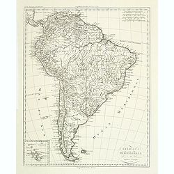
Amérique méridionale. . .
Detailed map of South of America. Includes a cartouche for the Galapagos island.Jean Baptiste Poirson (1760-1831) was a French geographer and engineer.
Date: Paris, 1808
Selling price: ????
Please login to see price!
Sold in 2011
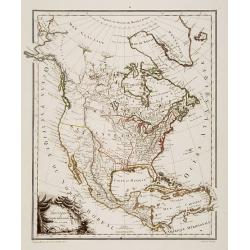
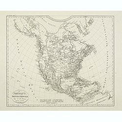
Amérique Septentrionale.
A charming map of North America. Very detailed. Published by Alexandre Emile Lapie, in his atlas Universel. Engraved by Tardieu.
Date: Paris 1809
Selling price: ????
Please login to see price!
Sold
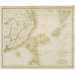
Carte des Isles Formose, Madjicosemah et Lieu-Kieu..
Rare map of Taiwan, the Lieu-Kieu Islands and the coast of China, including Hong Kong and Nanking.Engraved by Tardieu.
Date: Paris 1809
Selling price: ????
Please login to see price!
Sold
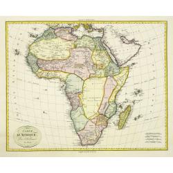
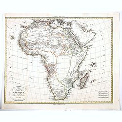
Carte d'Afrique. Par J.B. Poirson. An 1809
Detailed map of Africa prepared by Jean-Baptiste POIRSON (1761-1831).
Date: Paris, J.B.P.Tardieu, c.1809
Selling price: ????
Please login to see price!
Sold in 2011
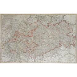
Das Sconigr. Sachsen mit den Kurfurstlich und Herzoglich Saechsischen Laendern. . .
Detailed map of the region of eastern Germany published by the Nuremberg firm Schneider and Weigel in 1809. Shows the cities of Berlin (at the north), Dresden, Leipzig an...
Date: Nuremberg, 1809
Selling price: ????
Please login to see price!
Sold in 2010
Amerique Septentrionale. . .
Detailed map of the United States and Canada giving good detail along the east coast and the Lakes. Including Port St.Francois, Monterey, Pte. De Pins, Pt.Estero, Pte de ...
Date: Paris, 1809
Selling price: ????
Please login to see price!
Sold in 2011
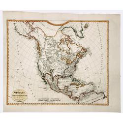
AMERIQUE SEPTENTRIONALE.
A detailed map of North America, issued shortly before the publication of the official account of Lewis & Clark's expedition to the Pacific Ocean. The map shows a ver...
Date: Paris, 1809
Selling price: ????
Please login to see price!
Sold in 2019
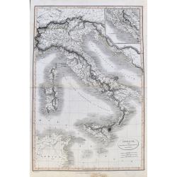
Italia, cum insulis et regionibus finitimis.
A large and unusual map of Italy from Smith's 'Classical Atlas'. It shows all of Italy with Corsica, Sardinia, Sicily, and Malta. Filled with historic place names. An ins...
Date: London, 1809
Selling price: ????
Please login to see price!
Sold in 2021
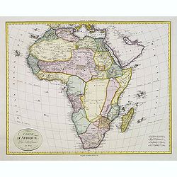
Carte d'Afrique. Par J.B. Poirson. An 1809
A comprehensive and quite detailed map of Africa prepared by Jean-Baptiste Poirson (1761-1831). With plenty of good coastal detail, vast 'chunks' of the interior of the c...
Date: Paris, 1809
Selling price: ????
Please login to see price!
Sold in 2020
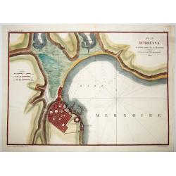
PLAN D'ODESSA, et d'une partie de ses Environs . . .
A rare large copper engraved map of Odessa, by P.Lapie. One of the earliest plans of this town, produced just 15 years after it's founding in 1794. From: "Notice sur...
Date: Paris, 1809
Selling price: ????
Please login to see price!
Sold in 2021
Carte d'Afrique. Par J.B. Poirson. An 1809
Detailed map of Africa prepared by Jean-Baptiste POIRSON (1761-1831).
Date: Paris, J.B.P.Tardieu, c.1809
Selling price: ????
Please login to see price!
Sold
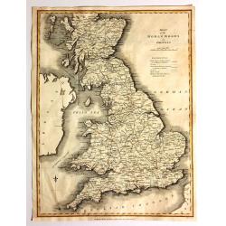
Map of the Roman Roads in Britain
Interesting map featuring the comparison of current roads (in 1809) to the ancient Roman roads. It was published by J. White, and the engraver was Neele. I could not find...
Date: London, 1809
Selling price: ????
Please login to see price!
Sold in 2017
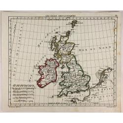
Les Isles Britanniques.
Interesting map of the British Isles engraved on copper by Glot. From the scarce “Atlas Portatif, contenant la G‚ographie Universelle Ancienne et Moderne” by Eustac...
Date: Paris, 1809
Selling price: ????
Please login to see price!
Sold in 2018
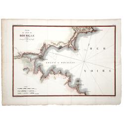
Plan du Golfe de BOURGAS.
A beautifully colored map, depicting the Bourgas gulf in Bulgaria. Taken from Pierre Lapie's work: "Reconnoissance nautique et militaire du Golfe de Bourgas", M...
Date: Paris, 1809
Selling price: ????
Please login to see price!
Sold in 2019
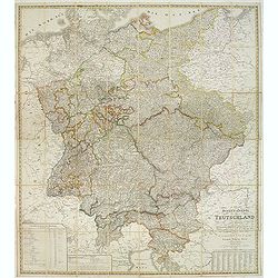
General-Karte von Teutschland in vier Blättern welche als Uebersichts-Tableau der Grosse Charte in 204 Blättern zugleich aber auch als vollständige Post- und orographische Charte dienen kann . . .
Napoleonic folding map of Germany and Italy prepared by Friedrich Wilhelm Streit. Also including Austria, Slovenia, Czech Republic etc.The map has been published during t...
Date: Weimar, 1810
Selling price: ????
Please login to see price!
Sold in 2013

Merkwurdige Gebaude in St. Petersburg
Attractive hand-colored engraving featuring The Cathedral and The Stock Market in St. Petersberg, Russia. Bertuch's "Bilderbuch für Kinder", is an enlightened...
Date: Weimar, 1810
Selling price: ????
Please login to see price!
Sold in 2013
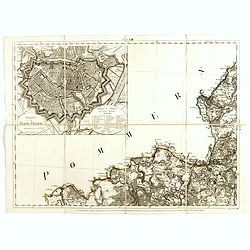
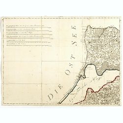
(Single sheet Sect. VIII with inset of Danzig from) Karte von Alt-Preussen enthaltend Ost=Preusen nebst Preussisch Lithauen. . .
Section VIII of the rare first edition of this important 25-sheet map prepared by Friedrich Leopold von Schrötter. This map sheet was engraved by Paulus Schmidt.In the u...
Date: Berlin, ca.1803-1810
Selling price: ????
Please login to see price!
Sold in 2016
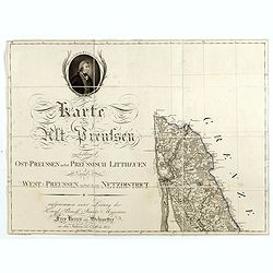
(Single sheet from) Karte von Alt-Preussen enthaltend Ost=Preusen nebst Preussisch Lithauen. . . 1796 bis 1802.
The title section of this important multi-sheet map of Prussia, Lithuania, and Poland, showing territories of present Lithuania (Klaipeda district). With a medallion repr...
Date: Berlin, 1802-1810
Selling price: ????
Please login to see price!
Sold in 2014
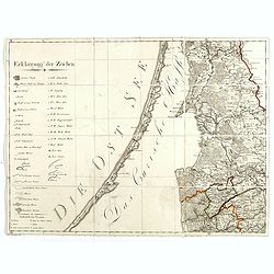
(Key sheet) General Tableau zur Karte von Alt Ost und West Preussen nebst dem aufgenommenen Trigonometrischen Netz. . .
Sheet II with part of Lithuania and the Key of this important multi sheet map of Prussia, Lithuania and Poland.The rare first edition of this important 25-sheet map prepa...
Date: Berlin, 1802-1810
Selling price: ????
Please login to see price!
Sold in 2014
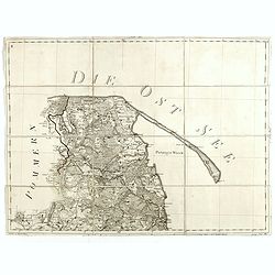
(Kaliningrad, Sheet VI of ) General Tableau zur Karte von Alt Ost und West Preussen nebst dem aufgenommenen Trigonometrischen Netz. . .
Sheet VI centered on Kaliningrad Oblast, the Russian exclave between Poland and Lithuania on the Baltic Sea., from this important multi sheet map of Prussia, Lithuania an...
Date: Berlin, 1802-1810
Selling price: ????
Please login to see price!
Sold in 2016
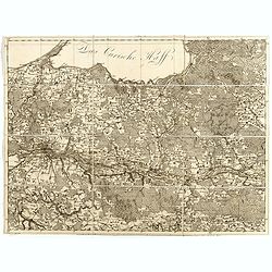
(Sheet IV with Puk Bay from) General Tableau zur Karte von Alt Ost und West Preussen nebst dem aufgenommenen Trigonometrischen Netz. . .
Sheet IV with Puk Bay and part of Gdansk Bay of this important multi sheet map of Prussia, Lithuania and Poland.The rare first edition of this important 25-sheet map prep...
Date: Berlin, 1802-1810
Selling price: ????
Please login to see price!
Sold in 2016
(East of Kaliningrad, Sheet VI of ) General Tableau zur Karte von Alt Ost und West Preussen nebst dem aufgenommenen Trigonometrischen Netz. . .
Sheet VI centered eastern part of Kaliningrad Oblast, the Russian exclave between Poland and Lithuania on the Baltic Sea., from this important multi sheet map of Prussia,...
Date: Berlin, 1802-1810
Selling price: ????
Please login to see price!
Sold in 2016
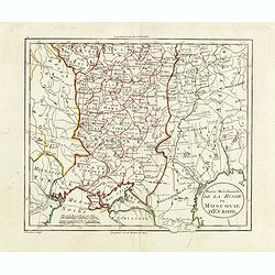
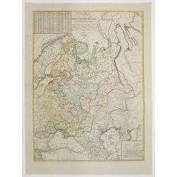
Partie méridionale de la Russie ou Moscovie d'Europe.
Map of part of Russia, focusing on Ukraine. The map is based on the Paris Meridian, only in 1884, at the International Meridian Conference in Washington DC, the Greenwich...
Date: Paris, c. 1810
Selling price: ????
Please login to see price!
Sold in 2015
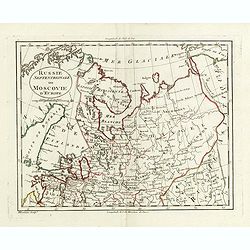
Russie septentrionale ou Moscovie d'Europe.
Map of northern part of European Russia. The map is based on the Paris Meridian, only in 1884, at the International Meridian Conference in Washington DC, the Greenwich Me...
Date: Paris, c. 1810
Selling price: ????
Please login to see price!
Sold in 2015
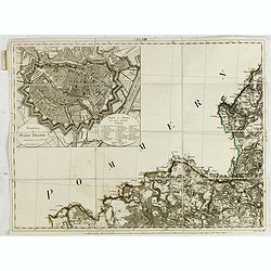
(Single sheet Sect. VIII with inset of Danzig from) Karte von Alt-Preussen enthaltend Ost=Preusen nebst Preussisch Lithauen. . .
Section VIII of the rare first edition of this important 25-sheet map prepared by Friedrich Leopold von Schrötter. This map sheet was engraved by Paulus Schmidt.In the u...
Date: Berlin, ca.1803-1810
Selling price: ????
Please login to see price!
Sold in 2015
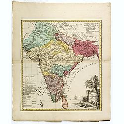
Charte von OstIndien nach I.Rennel von Gebr. Lotter.
Decorative map in very good condition with a title cartouche at bottom right, scale bars at the top right, bottom left color key legend.A rare map published by After a ma...
Date: Augsburg, 1777/1810
Selling price: ????
Please login to see price!
Sold
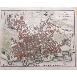
Plan der Stadt Liverpool.
Anonymous copper engraved plan of Liverpool, with German title but printed in Prague. Names numerous streets and buildings, and several docks and yards along the Mersey r...
Date: Prague, 1810
Selling price: ????
Please login to see price!
Sold in 2015
Carte des Rivieres et Ruisseaux du Bassin de la Seine, qui servent a l'Approvisionnement de Paris.
Map of rivers and streams of the Seine basin that supply Paris, France , divided into departments indicating the offices of supply. The map was dedicated to Commissioner ...
Date: Paris, ca. 1810
Selling price: ????
Please login to see price!
Sold in 2023
![[BATTLE PLANS]](/uploads/cache/95908-250x250.jpg)
[BATTLE PLANS]
Two general plans of the Battles of Pyramides and Aboukir, dated 1798 and 1799, showing the events when Napoleon defeated the Egyptian and Turkish armies.
Date: Paris, 1810
Selling price: ????
Please login to see price!
Sold in 2016

Prise de la ville de Vienne Capitale de l'Autriche.
Print published in "Paris chez la Ve. Chéreau M.de d'estampes, rue St. Jacques N°10, aux deux Colonnes, près la Fontaine St. Séverin". The text below the pr...
Date: Paris, Vve. Chéreau, ca 1810
Selling price: ????
Please login to see price!
Sold in 2016
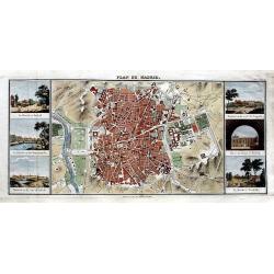
Plan de Madrid.
Very rare plan of Madrid. Names major streets, places, buildings, and gardens. Flanked by six views: La Florida á Madrid; Le Palais vu du Manzanarés; Madrid vu du coté...
Date: Paris, ca. 1810
Selling price: ????
Please login to see price!
Sold in 2016

Vues des Cordillères et Monuments des Peuples Indigènes de l Amérique. . .
The book describes the travels of Alexander Humbolt together with the botanist Aime Bonpland in 1799 via Tenerife to Venezuela, through the Orinoco area and through Colom...
Date: Paris, [de l'imprimerie de J.H. Stône] chez F. Schoell, 1810
Selling price: ????
Please login to see price!
Sold
A new and elegant general atlas, dedicated to Her Royal Highness Charlotte Augusta, Princess . . .
With printed title "Laurie and Whittle new and accurate general atlas: chiefly intended for the use of schools, and convenience of gentlemen's libraries: also to acc...
Date: London, 1810
Selling price: ????
Please login to see price!
Sold in 2021
Carta dell'Italia superiore e di parte degli stati limitrofi.
Map of northern Italy and adjacent states by cartographer and engraver Giuseppe Caniani, reduced from the map of Bacler d'Albe.
Date: Milan, ca. 1810
Selling price: ????
Please login to see price!
Sold in 2018
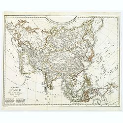
Carte d'Asie.
An informative map of the continent of Asia by the French engineer and geographer, Jean-Baptist Poirson. Map covers from the northern tip of Australia, up to the Behring ...
Date: Paris, 1810
Selling price: ????
Please login to see price!
Sold in 2018
La Ville du Cap de Bonne Esperance.
A very pretty and attractive view of Cape Town in South Africa, from Bertuch's Bilderbuch fur Kinder.The view is beautifully hand colored and comes with original accompan...
Date: Weimer, 1810
Selling price: ????
Please login to see price!
Sold in 2018

Vaisseaux des Anciennes / Construction de Vaisseaux.
An attractive pair of prints concerning boat building, and boat from ancient times past, printed in Germany. Complete with original pages of (French) text. From Bilderbuc...
Date: Weimar, 1810
Selling price: ????
Please login to see price!
Sold in 2020
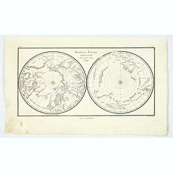
Regioni Polari Paragonate. . .
An unusual item, an Italian map of the poles. Information is confined to mountains, rivers, tracks, and some major cities. Unsurprisingly, there is more information about...
Date: Milano, ca 1810
Selling price: ????
Please login to see price!
Sold in 2021
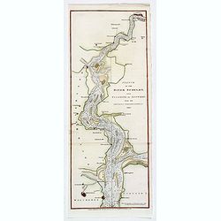
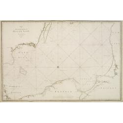
Sketch of the River Scheldt, from Flushing to Antwerp with the Soundings Fortifications, &c. 1810
A chart of a portion of the Scheldt River in Belgium. It is after the earlier work by the French hydrographer Beautemps Beaupre. Named places include: Antwerp, Fort Lillo...
Date: London, 1810
Selling price: ????
Please login to see price!
Sold in 2019
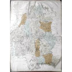
Karta öfver Jönköpings Kronobergs och Blekings Höfdingdöme utgifven af Friherre S. G. Hermelin.
A highly detailed large-scale map of Småland and Blekinge in southern Sweden. The map shows the area from Gränna and Jönköping with the Vättern lake, until Kristians...
Date: Stockholm, 1810
Selling price: ????
Please login to see price!
Sold in 2019
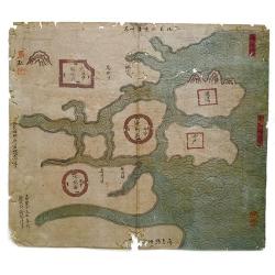
Haizhou Prefecture, Jiangsu Province.
A very rare Qing era manuscript map of Haizhou Prefecture in Jiangsu province, China showing coastal area, islands and ocean. Dated as made in 1810 by Yu Dengda from Haiz...
Date: Haizhou, 1810
Selling price: ????
Please login to see price!
Sold in 2019
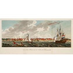
Vue de la Rade et de la Ville de Paramaribo.
A very decorative panoramic view of the town with a large Dutch vessel in the foreground.
Date: Paris 1810
Selling price: ????
Please login to see price!
Sold
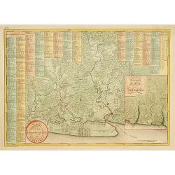
Kaart van het bebouwde gedeelte van Suriname.
With inset map of general Suriname. Scarce map covering the area of Paramaribo. 751 Plantation identified to key panels at top and left of the sheet.
Date: Amsterdam, 1810
Selling price: ????
Please login to see price!
Sold in 2013
Karta öfver Syd Ostra Delen af Öster Sjön..
Uncommon chart centred on the southern part of the Baltic Sea, giving good detail of the southern Swedish coast, part of Poland, Russia, Lithuania and Latvia.Decorated wi...
Date: Stockholm 1810
Selling price: ????
Please login to see price!
Sold
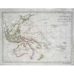
Australien nach den neuesten astronomischen Bestimmungen und Entdeckungs-Reisen
Scarce Austrian map of Australia and Oceania. Published in this state only in "Lehrbuch der Geographie". Large and detailed map, filled with numerous place name...
Date: Vienna, ca. 1810
Selling price: ????
Please login to see price!
Sold in 2008
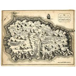
The Island & Forts of St. Helena.
Striking and extremely detailed map of St. Helena. Shows many individual buildings with their residents' last names. Including Farms, Napoleon Bonapartes Residence, an Al...
Date: England ?, c.1810
Selling price: ????
Please login to see price!
Sold in 2009
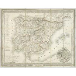
Carte des routes de postes et itinéraires d'Espagne et de Portugal par Ch. Pochet. . .
A charming dissected, linen mounted post route map of Spain and Portugal. With inset of the area around Madrid. Prepared by Lapie, who according to the title used materia...
Date: Paris, 1810
Selling price: ????
Please login to see price!
Sold in 2009
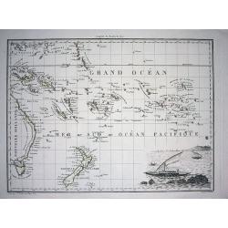
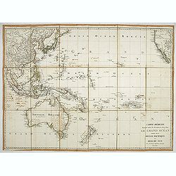
Océanique Orientale.
Interesting map showing the area from the Carolines to Tahiti and the Pitcairn Island, also New Zealand, and Australia from Torres Strait to Tasmania. Engraved by J.B.Tar...
Date: Paris, c1810
Selling price: ????
Please login to see price!
Sold in 2010
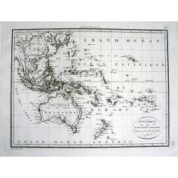
Océanie ou Australasie et Polynesie.
Detailed map of South-East Asia, Indonesia, Australia, parts of the South Pacific, and New Zealand. Includes also Japan and the Philippines A rare edition of this detail...
Date: Paris, 1810
Selling price: ????
Please login to see price!
Sold in 2011
General Charte des Russischen Reichs Europaeis- chen antheils, nach der grossen Charte der Akademie zu Petersburg in 100 blatter. . . .
Uncommon and detailed map of the European part of Russia. The Ukraine and Crimea are marked as "Neu Russische Provinzen." Based on the Stolistowaja = 100-sheet ...
Date: Weimar, 1810
Selling price: ????
Please login to see price!
Sold in 2015
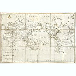
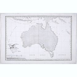
Planisphere ou carte générale du globe par j.B. Poirson. . .
Detailed world map centered on Australia, prepared by J.B.Poirson (1761-1831) in 1810. The map seems to have been used on board of a ship showing its track in the year 18...
Date: Paris, 1810
Selling price: ????
Please login to see price!
Sold in 2011
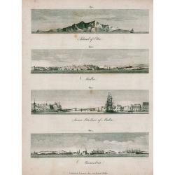
Elba, Malta, Alexandria.
Unusual sheet with four attractive views from the seaside: Island of Elba, Malta, Inner Harbour of Malta, Alexandria. Small but detailed views, showing buildings, sailin...
Date: London, 1810
Selling price: ????
Please login to see price!
Sold in 2011
Carte réduite donnant toutes les découvertes faites dans le grand océan. . .
A fine map of the Pacific Ocean, published in Paris by Poirson. The map shows Australia with the complete coastline and "Terre Bonaparte" four years before the ...
Date: Paris 1810
Selling price: ????
Please login to see price!
Sold in 2021
![[Lot of 2 manuscript maps] Schetskaart van het westelijk vaarwater naar de reede van Ternate. [together with ] Sketch of the island of Ternate, Tidore and to the Southward.](/uploads/cache/47989-250x250.jpg)
[Lot of 2 manuscript maps] Schetskaart van het westelijk vaarwater naar de reede van Ternate. [together with ] Sketch of the island of Ternate, Tidore and to the Southward.
Two rare manuscript maps being one general map of the spice islands and a detailed map of the South Western Channel in front of the town Ternate with the island "Noo...
Date: Ternate ?, ca. 1800-1810
Selling price: ????
Please login to see price!
Sold in 2022
Carte Generale de la Nouvelle Hollande.
Fine map of the continent of Australia prepared by Louis Freycinet during his voyage under Captain Thomas Baudin in 1800-1803. Freycinet's map of New Holland was the firs...
Date: Paris, Imprimerie Royale, 1811
Selling price: ????
Please login to see price!
Sold in 2020
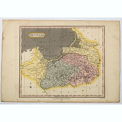
Prussia.
A general map of Prussia, engraved by J.Wallis for Oddy's General Atlas in full original color. Prussia was a historically prominent German state that originated in 1525 ...
Date: London, 1811
Selling price: ????
Please login to see price!
Sold in 2021
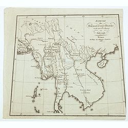
Entwurf des Birmanschen Reichs nach einer Leichnung. . .
A pleasant, simple map of the Burmese Empire, based on a drawing by Alexander Dalrymple. The map is drawn on a slightly trapezoidal projection, with the base being wider ...
Date: Weimar, 1811
Selling price: ????
Please login to see price!
Sold in 2021
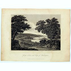
George Town and City of Washington.
A delightful bucolic copperplate engraving of the village of 'George Town' and the neighbouring 'City of Washington' by the Potomac River. Georgetown is a historic suburb...
Date: London, 1811
Selling price: ????
Please login to see price!
Sold in 2021
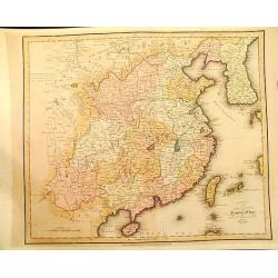
The Empire of China Divided into Separate Provinces from the Latest and Best Authorities.
Uncommon map of China and Korea.
Date: Edinburgh, 1811
Selling price: ????
Please login to see price!
Sold in 2012
The Dutch colony of the Cape of Good Hope / by L.S. De La Rochette.
Uncommon detailed map of the Cape of Good Hope, showing kraals or villages, fountains, river crossings, early settlers, anchorages, etc. Prepared by Louis Stanislas d'Arc...
Date: London, 1795-1811
Selling price: ????
Please login to see price!
Sold in 2013
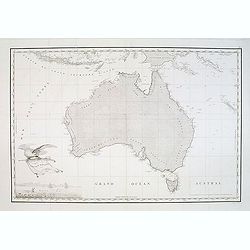
Carte Generale de la Nouvelle Hollande.
The Freycinet map of Nouvelle Hollande is generally recognized as the first full map of Australia to be published. In historical context the map is the culmination of a l...
Date: Paris, 1811
Selling price: ????
Please login to see price!
Sold in 2012
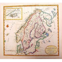
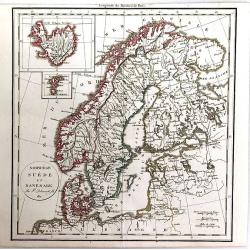
Sweden, Denmark, Norway and Finland from the Best Authorities.
A fine copper engraving map of Scandinavia engraved for Carey's American Edition of "Guthrie's Geography" improved. It has an inset of Iceland. Engraved by Sidn...
Date: Philadelphia, 1811
Selling price: ????
Please login to see price!
Sold in 2013
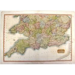
England, Southern Part.
A fine, detailed map of southern England and the English Channel. John Pinkerton (1758 – 1826) was a Scottish antiquarian, cartographer and historian. Pinkerton was a...
Date: London, 1811
Selling price: ????
Please login to see price!
Sold in 2015
![Death of Sir Philip Sidney [and] Lord Russell's Last Interview With His Family. [Lot of 2 prints]](/uploads/cache/93700-250x250.jpg)
Death of Sir Philip Sidney [and] Lord Russell's Last Interview With His Family. [Lot of 2 prints]
Two decorative copper engravings featuring history scenes. They were engraved by A. Smith and published in "ASHBURTON'S HISTORY" by J. Stratford in 1811.
Date: London, 1811
Selling price: ????
Please login to see price!
Sold in 2015
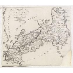
Charte von Japan mit seinen VII Provinzen nach Robert's Entw.
A detailed and scarce map of Japan after Gilles Robert. The map is of interest for the double naming of "Meer von Corea" and Meer von Japan.", the sea betw...
Date: Weimar, 1811
Selling price: ????
Please login to see price!
Sold in 2015
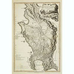
Carte Generale de la Terre Napoleon (a la Nouvelle Hollande)... par M.L. Freycinet an 1808.
The First Detailed Mapping of the Adelaide Region ( identified as B. Dugueselin, C. Sully and C. Mondovi) and centered on Kangaroo Island (Ile Decres) and extends east to...
Date: Paris, 1811
Selling price: ????
Please login to see price!
Sold in 2015
![Plan d'une partie de la Terre Napoleon (Nouvelle-Hollande) par M. M. H. Freycinet et Bernier, an 1802. [with] Plan des Iles Josephine et de la Baie Murat (a la Terre Napoleon, Nouvelle-Hollande) . . .](/uploads/cache/36244-250x250.jpg)
Plan d'une partie de la Terre Napoleon (Nouvelle-Hollande) par M. M. H. Freycinet et Bernier, an 1802. [with] Plan des Iles Josephine et de la Baie Murat (a la Terre Napoleon, Nouvelle-Hollande) . . .
Two maps showing Descartes Bay and Bridgewater Bay in Victoria and Murat Bay in South Australia showing French discoveries prepared by Louis Freycinet during his voyage u...
Date: Paris, Langois, 1811
Selling price: ????
Please login to see price!
Sold in 2017
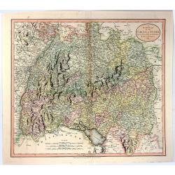
A New Map of the Circle of Swabia, from the Latest Authorities
A fine map of the Swabia region of Germany. Map covers from the Upper Rhine region south as far as Switzerland. Extends eastward as far as Bavaria and westward as far as ...
Date: London, 1811
Selling price: ????
Please login to see price!
Sold in 2016
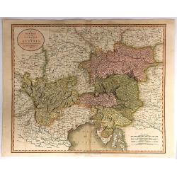
A New Map of the Circle of Austria, From the Latest Authorities . . .
A detailed map of John Cary’s Austria, from the important early 19th century “NEW UNIVERSAL ATLAS”. It covers from Lake Constance and eastward as far as Lake Pelso...
Date: London, 1811
Selling price: ????
Please login to see price!
Sold in 2018
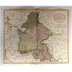
A New Map of the Circle of Bavaria, From the Latest Authorities . . .
A detailed map of John Cary’s Bavaria, from the important early 19th century “NEW UNIVERSAL ATLAS”. The map covers the entire circle of Bavaria. Ronald Vere Tooley...
Date: Paris, 1811
Selling price: ????
Please login to see price!
Sold in 2017
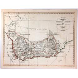
Charte der Sudspize von Africa oder des Hottentotten und Caplands.
A copper engraved map, published in 1811 in Prague. A rare Prague Issue of John Barrow's Map, originally published in 1802 for "An Account of Travels Into the Interi...
Date: Prague, 1811
Selling price: ????
Please login to see price!
Sold in 2016
Norwege, Suede et Danemark.
A striking map of Scandinavia, with a large inset of Iceland, and a smaller one of the Faroe Islands. Félix Delamarche was a French geographer and engineer who flourishe...
Date: Paris, 1811
Selling price: ????
Please login to see price!
Sold in 2016
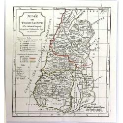
Judee ou Terre Sainte.
A pleasant map of present day Israel and Jordan. Below the title cartouche are keys to three divisions of the land: the twelve tribes, the six provinces under Herod the ...
Date: Paris, ca. 1811
Selling price: ????
Please login to see price!
Sold in 2016
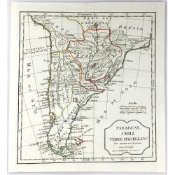
Paraguay, Chili, Terre Magellan. . .
An antique copper engraved map, published 1795, in Paris for the "Nouvel Atlas Portatif..." by Robert de Vaugondy & Charles Francois Delamarche.
Date: Paris, ca. 1811
Selling price: ????
Please login to see price!
Sold in 2016

A New Map of the Kingdom of Prussia ...
A fine map by John Cary of Prussia.
Date: London, 1811
Selling price: ????
Please login to see price!
Sold in 2016