Browse Listings
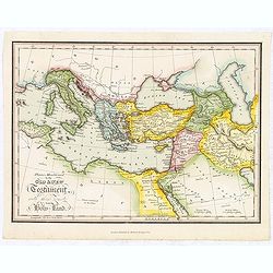
Places Mentioned in the Old & New Testament with those remote from the Holy Land.
Map of the Mediterranean with places of the Old and New testament underlined. From "The Scripture atlas or a series of maps…"
Place & Date: London, 1812
Selling price: $12
Sold in 2018
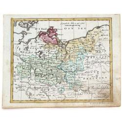
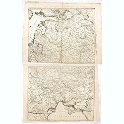
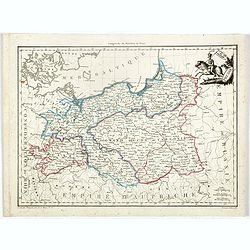
Obersachsischer Kreis Nordlicher Theil. (Brandenberg & Pommern)
Infomative little map of Brandenberg and Pommern. By Johann Walsh (1757 - 1824) from the 1812 edition of his atlas, "ALLGEMEINER ATLAS NACH DEN BEWAHSTEN".
Place & Date: Augsburg, 1812
Selling price: $11
Sold in 2016
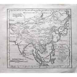
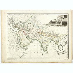
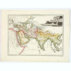
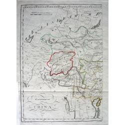
Charte von China...
Unusual map of east Asia, from India to Japan, including parts of Russia, and Indonesia. With several notes in German. A very interesting and rare map!
Place & Date: Prague, 1812
Selling price: $70
Sold in 2014
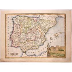
Espagne et Portugal.
This map of Spain and Portugal was included in Malte-Brun's "ATLAS COMPLETE DU [RECIS DE LA GEOGRAPHIC UNIVERSELLE" published in Paris in 1812. The artist and e...
Place & Date: Paris, 1812
Selling price: $55
Sold in 2015
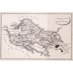
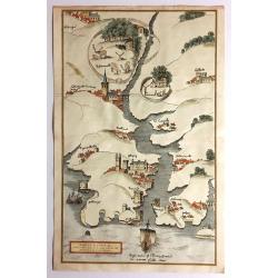
A Special Map of the Isle of Taman.
A detailed small plan of The Island of Taman in fact a peninsula was a strategic location on the Sea of Azof taken from ‘Travels through the southern Provinces of the ...
Place & Date: London, 1812
Selling price: $50
Sold in 2014
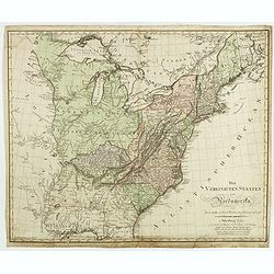
Die Vereinigten Staaten von Nordamerika nach Arrowsmith und Lewis Karten vom Jahre 1795 und 1796. . .
A uncommon map of the United States, according to the title based on the maps by Arrowsmith and Lewis published in 1795 and 1796. Roads and Indian tribes are noted, in ad...
Place & Date: Nuremberg, 1812
Selling price: $850
Sold in 2016
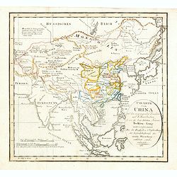
Charte von China und den angränzenden Ländern und Völkerschaften so wie den letzten Kaiser Tschien-Long. . .
Uncommon map of China on a scale of ca. 1:6,000,000. The map's complete title is “Charte von China und den angränzenden Ländern, und Völkerschaften so wie sie dem le...
Place & Date: Prague, 1812
Selling price: $225
Sold in 2015
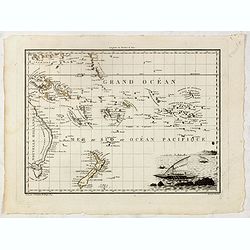
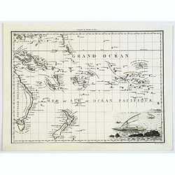
Océanique orient.
In lower right hand corner a view of sailor. An steel engraved map showing part of the east coast of Australia with Torres Strait to Tasmania., the Marquesas, the Carolin...
Place & Date: Paris, 1812
Selling price: $250
Sold in 2015
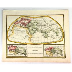
Systemes Geographiques de Ptolemee, Strabon et de'Eratosthene.
This informative map shows side-by-side the differences between the Ptolemee, Strabon et de'Eratosthene maps of the world. The map was by Giraldon, and engraved by Chamou...
Place & Date: Paris, 1812
Selling price: $80
Sold in 2016
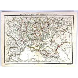
Russie D'Europe (Partie Neridionale)
A fine map of southwestern Russia by Charles Francois Delamarche in Paris in 1812. C.F. Delamarche was a French geographer and mapmaker. He was the successor to Robert de...
Place & Date: Paris, 1812
Selling price: $17
Sold in 2016
Océanique orient.
In lower right hand corner a view of sailor. An steel engraved map showing part of the east coast of Australia with Torres Strait to Tasmania., the Marquesas, the Carolin...
Place & Date: Paris, 1812
Selling price: $250
Sold in 2016
Neue militairische Situations Karte von West-Russland ... (2 sheets)
Rare road map of Western Russia in two sheets. Prepared by J.E. Knittel. Scale ca. 1:1 400 000.
Place & Date: Nürnberg, 1812
Selling price: $170
Sold in 2016
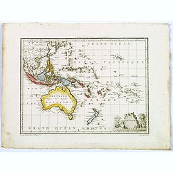
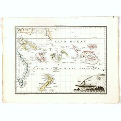
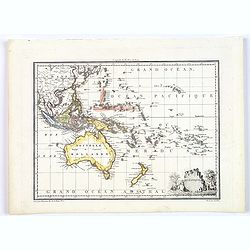
Oceanique.
A map covering Australia, New Zealand, the Pacific Islands ,South East Asia, and part of China. A small decorative title cartouche is seen in the lower right corner. From...
Place & Date: Paris, 1812
Selling price: $90
Sold in 2017
![[2 sheet wall map] Carte de l'empire français et de l'Allemagne, où l'on a marqué en lieues respectives, les postes de ces deux grandes parties de l'Europe / dressée par Hérisson, . .](/uploads/cache/39671-250x250.jpg)
[2 sheet wall map] Carte de l'empire français et de l'Allemagne, où l'on a marqué en lieues respectives, les postes de ces deux grandes parties de l'Europe / dressée par Hérisson, . .
A large, two sheet folded post road maps of France, Germany the Low Counties, Poland, Austria, Switzerland map of Africa, can be joined to make a wall map. Prepared and p...
Place & Date: Paris, Basset, 1812
Selling price: $1000
Sold
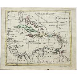
Westindien.
A scarce map of South America and Caribbean. Published in “Allgemeiner Atlas” by Johann Walch (1757-1824). He was a cartographer and map publisher active in Augsburg,...
Place & Date: Augsburg, 1812
Selling price: $17
Sold in 2018
Asie Ancienne.
Map of ancient Asia with interesting detail on Arabia and India. From the "Atlas Complet du precis de la Geographie Universelle…". Maps from this atlas were a...
Place & Date: Paris, 1812
Selling price: $130
Sold in 2017
Grand Duche de Varsovie. Prusse.
Steel engraved map of Poland Warsaw Duchy. From the "Atlas Complet du precis de la Geographie Universelle…". Maps from this atlas were accurate, and reflected...
Place & Date: Paris, 1812
Selling price: $200
Sold in 2023
Oceanique.
A map covering Australia, New Zealand, the Pacific Islands ,South East Asia, and part of China. A small decorative title cartouche is seen in the lower right corner. From...
Place & Date: Paris, 1812
Selling price: $70
Sold in 2018
Océanique orient.
In lower right hand corner a vignette view of Pacific sailing craft. A nice steel engraved map showing part of the east coast of Australia from the Torres Strait to Tasma...
Place & Date: Paris, 1812
Selling price: $80
Sold in 2017
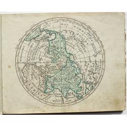
Halb = Kugel der Erde nach Sicklers Theorie der vulkanischen Linien.
A nice, scarce map of the Northern hemisphere. Published in “Allgemeiner Atlas” by Johann Walch (1757-1824). He was a cartographer and map publisher active in Augsbur...
Place & Date: Augsburg, 1812
Selling price: $40
Sold in 2018
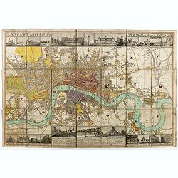
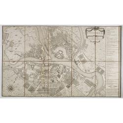
Langley & Belch's New Map of London.
Decorative plan of London, with illustrated views of prominent London buildings (including the newly opened docks) along the top and bottom of the plate. The plan is divi...
Place & Date: London, 1812
Selling price: $1000
Sold in 2020
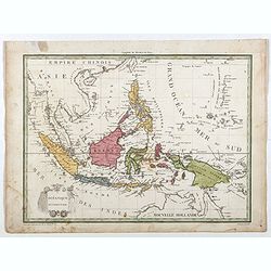
Océanique Occidentale.
Showing Indonesia, with good detail on the Philippines. Engraved by Chamouin and prepared by Giraldon. Nice title, cartouche with octopus sea creatures.From Conrad Malte-...
Place & Date: Paris, 1809/1812
Selling price: $100
Sold in 2018
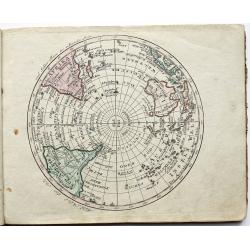
Halb = Kugel der Erde nach Sicklers Theorie der vulkanischen Linien.
A scarce map of Southern hemisphere. Published in “Allgemeiner Atlas” by Johann Walch (1757-1824). He was a cartographer and map publisher active in Augsburg, he was ...
Place & Date: Augsburg, 1812
Selling price: $40
Sold in 2018
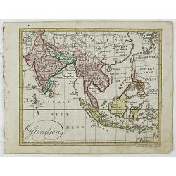
Ostindien.
A scarce map of China, India, Japan, Indonesia, Borneo, Taiwan and many other countries. Published in "Allgemeiner Atlas" by Johann Walch (1757-1824). He was a ...
Place & Date: Augsburg, 1812
Selling price: $40
Sold in 2018
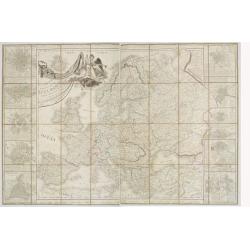
Carte des Europaisch- und eines Theils des Asiatisch russischen Reichs, nach den Neuesten Astronomischen Ortsbestimungen, den Grossen Atlas und Andern Karten des Russich-Kaiserl: Karten-Depots Verfasst ...
A large, rare (wall map sized) folding map of Russia, Lithuania, Poland with title in German and French published during the year of the Napoleonic campaign. Set consists...
Place & Date: Vienna, T. Mollo, 1812
Selling price: $1000
Sold in 2018
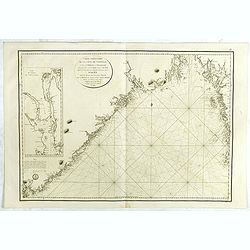
Carte particulière de la côte de Norwége, à l'est de Flekkeröe et Christiansand, avec partie de la côte de Suède jusqu'à. . .
Large sea chart showing northern part of Skagerrak with the coast of Norway with Kristiansand till Frederiksted and the Swedish coast till just north of Gothenburg. The c...
Place & Date: Paris, 1812
Selling price: $200
Sold in 2018
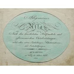
Allgemeiner Atlas Nach den bewährsten Hülfsmitteln und astronomischen Ortsbestimungen. . .
Title page by Johannes Walch from his rare Allgemeiner Atlas Nach den bewährsten Hülfsmitteln und astronomischen Ortsbestimungen…, the edition of 1812.
Place & Date: Augsburg, 1812
Selling price: $50
Sold in 2020
Asie Ancienne.
A striking map of ancient Asia, with interesting detail on Arabia and India. From the "Atlas Complet du precis de la Geographie Universelle…". Maps from this ...
Place & Date: Paris, 1812
Selling price: $15
Sold in 2020
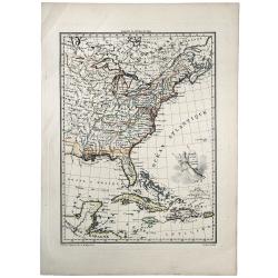
ETATS UNIS ET GRANDES ANTILLES.
An attractive map of the United States and West Indies with decorative cartouche, from 'Atlas Supplementaire du Precis de la Geographie Universalle de M. Malte-Brun by La...
Place & Date: Paris, 1812
Selling price: $41
Sold in 2019
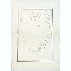
Carte Generale de la Terre de Diemen. . .
A detailed chart of the island of Tasmania and published by expedition member Louis Claude Desaulses de Freycinet, the first to show the entire island and to focus exclus...
Place & Date: Paris 1812
Selling price: $800
Sold in 2019
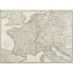
Carte de l'empire français et du royaume d'Italie Divisée par departemens et divisions militaires, avec les etats qui composent la Confédération du Rin. . .
Historically interesting map the Empire of France, including Corsica, now-a-days northern Italy, Netherlands, Croatia, Belgium, Germany with the regions according the &qu...
Place & Date: Paris, 1813
Selling price: $150
Sold in 2012
![[No tittle] Lithuania and Poland. "A.6".](/uploads/cache/30629-250x250.jpg)
[No tittle] Lithuania and Poland. "A.6".
Very detailed map of Lithuania. Show the cities of Tilse, Chavli, Vilna. With parts of Poland. In upper right corner "A.6".Scale 1: 500.000. One sheet of from &...
Place & Date: Paris, 1812-1813
Selling price: $17
Sold in 2012
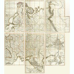
Topographische Karte von Deutschland und Italien nebst den angrenzenden Landern. . .
Second edition of this rare Napoleonic folding map of Germany and Italy prepared by Joseph Dirwalt. Also including present-day Poland, part of Austria, Switzerland, and s...
Place & Date: Vienna, 1813
Selling price: $365
Sold in 2013
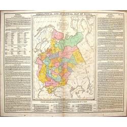
Geographical & Statistical Map of Russia.
Fine copper engraved map featuring Russia in Europe. Engraved by J. Walker after C. Gros and published by J. Barfield for Lavoisne's "COMPLETE GEOGRAPHICAL ATLAS&quo...
Place & Date: London, 1813
Selling price: $28
Sold in 2014
![Schauplatz des Kriegs in Polen und Russland darstellend. . . [with 15 maps of Poland]](/uploads/cache/36177-250x250.jpg)
Schauplatz des Kriegs in Polen und Russland darstellend. . . [with 15 maps of Poland]
An extremely scarce atlas which records the Russian campaign of 1812 and the continuation of the French army in Poland in 1813. Starting with a engraved title page in Ger...
Place & Date: Leipzig, 1813
Selling price: $2200
Sold in 2017
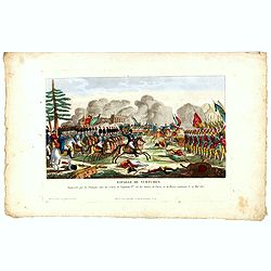
Bataille de Vurtchen Remportée par les Français, sous les ordres de Napoléon I.er sur les Armées de Prusse et de Russie, combinées le 20 Mai 1813.
Print published in "Paris chez Jean Rue Saint Jean de Beauvais N° 10". Showing the battle of Würschen won by Napoléon over the Prussian/Russian army.Read mor...
Place & Date: Paris, Jean, ca 1813
Selling price: $40
Sold in 2016
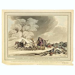
Bonaparte flight in disguise, from his ruined Grand Army in Russia 1812.
Aquatint from the Napoleonic Wars (1800-1815) by Matthew Dubourg (active 1786-1838), after James Atkinson (1780-1852), showing Napoleon and staff fleeing in covered sled ...
Place & Date: London, 1813
Selling price: $25
Sold in 2016
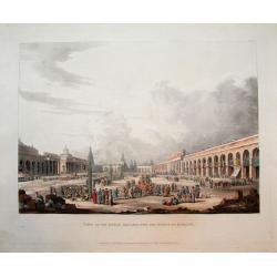
View of the Great Square, with the shops at Moscow.
Scarce aquatint with original hand-color. Shows the square with many people, horses, and goods being traded.This view was published in Ackermann's "Historical sketch...
Place & Date: London, 1813
Selling price: $50
Sold in 2016
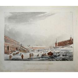
View of the ice hills, during the carnival at Moscow.
Scarce aquatint with original hand-color. Shows the a large square with many people, and horses pulling sledges!This view was published in Ackermann's "Historical sk...
Place & Date: London, 1813
Selling price: $50
Sold in 2016
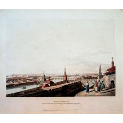
View of Moscow, taken from the balcony of the Imperial Palace.
Scarce aquatint with original hand-color. Shows a panorama of the city and the river. This view was published in Ackermann's "Historical sketch of Moscow" and i...
Place & Date: London, 1813
Selling price: $60
Sold in 2016
Western Africa.
Elephant folio sized map of Western Africa, extending from the Kingdom of Brak and Damel's Kingdom to the Gold Coast and the Slave Coast, and inland to Bibbie Lake, Jinba...
Place & Date: London, 1813
Selling price: $70
Sold in 2016
![[No title, showing central Ukrainia with Dnieper River and Marioupol in lower right corner. ]](/uploads/cache/35719-250x250.jpg)
[No title, showing central Ukrainia with Dnieper River and Marioupol in lower right corner. ]
Very detailed map of central Ukrainia with Dnieper River and Marioupol in lower right corner. Scale 1: 500.000. Upper right corner "C.9." One sheet of from &quo...
Place & Date: Paris, 1812-1813
Selling price: $150
Sold in 2017
![[No title, showing the Crimean Peninsula and Sea of Azov with Sevastopol . .] C.10.](/uploads/cache/35720-250x250.jpg)
[No title, showing the Crimean Peninsula and Sea of Azov with Sevastopol . .] C.10.
Very detailed map of larger part of Crimean Peninsula and Sea of Azov with Sevastopol . . Scale 1: 500.000. Upper right corner "C.10." One sheet of from "C...
Place & Date: Paris, 1812-1813
Selling price: $220
Sold in 2017
![[No title, showing Western Ukrania.] C.7.](/uploads/cache/35721-250x250.jpg)
[No title, showing Western Ukrania.] C.7.
Very detailed map of Western Ukrania. Scale 1: 500.000. Upper right corner "C.10." One sheet of 104 from "Carte de la Russie Européenne en LXXVII feuilles...
Place & Date: Paris, 1812-1813
Selling price: $190
Sold in 2020
![[Very detailed map of Eastern Ukrania.] C.8.](/uploads/cache/35722-250x250.jpg)
[Very detailed map of Eastern Ukrania.] C.8.
Very detailed map of larger part of Ukrania with city of Kharkov located in the east of Ukraine. Scale 1: 500.000. Upper right corner "C.8." One sheet of 104 fr...
Place & Date: Paris, 1812-1813
Selling price: $60
Sold in 2022
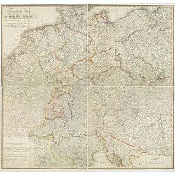
Carte générale d'Allemagne comprenant l'empire d'Autriche, la Confédération du Rhin, le Dannemarck, la Prusse et la Pologne, une partie de la Suède, des empires de France, de Russie et de Turquie . . .
Uncommon large folding map published during the Napoleonic Wars (1803–1815). Showing Central Europe, including Germany, Poland, Lithuania, Low Countries, Denmark, Easte...
Place & Date: Paris, Direction générale de l'imprimerie, 1813
Selling price: $500
Sold in 2019
South Africa.
A nicely engraved map with fine hand-coloring. Excellent detail with numerous place names. It also Includes several wells, missionary villages, and short notes.
Place & Date: London, 1813
Selling price: $40
Sold in 2017
St. Pétersbourg.
Beautiful and detailed plan of St. Petersburg engraved by Tardeau, originally for the Atlas Volume of "Histoire physique, morale, civile et politique de la Russie An...
Place & Date: Paris, 1813
Selling price: $750
Sold in 2019
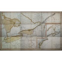
A Map exhibiting the frontiers of Canada and the United States, intended to illustrate the operations of the British & American armies
A scarce map issued during the War of 1812. Large inset lower right, "A sketch of the coast of North America; from the River St. Lawrence, to Chesapeake Bay." S...
Place & Date: London, 1813
Selling price: $4800
Sold in 2015
Kaiserthum China.
A fascinating and unusual copper-engraved map of the Aral lake to Hainan Island shows parts of today's China, Russia, Mongolia, India, Nepal, Bhutan, Bangladesh, and Myan...
Place & Date: Vienna, 1813
Selling price: $100
Sold in 2010
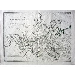
Asiatisches Russland.
Exciting and unusual copper-engraved map covering the area from Turkey to central Russia, showing parts of today's Russia, Kazakhstan, Ukraine, Georgia, Armenia, and Azer...
Place & Date: Vienna, 1813
Selling price: $100
Sold in 2010
Carte itinéraire et politique d'Europe d'après les derniers traités de paix avec les plans des principales villes d'Europe.. . .
Large map of Europe, surrounded wit views of Rome, Naples, Madrid, Lisbon, Berlin, Varsovie, Copenhagen, Paris, London, Vienna, St.Petersburg and Constantinople. Large ti...
Place & Date: Paris, 1813
Selling price: $900
Sold in 2010
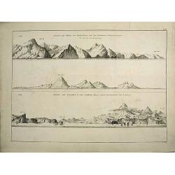
Views of the coast of Kamchatka.
An original view in imperial folio size, originating from the original first edition (Russian & German) of Krusenstern's atlas to his voyage around the world: Atlas k...
Place & Date: St. Petersburg, 1813-1814
Selling price: $900
Sold in 2011

Plate of a tattooed male from Nukuhiva (Marquesas Islands)
An original plate in imperial folio size, originating from Krusenstern's 1813-14 atlas (Russian & German language) to his voyage around the world: Atlas k puteshestvi...
Place & Date: St. Petersburg, 1813-1814
Selling price: $2250
Sold in 2011
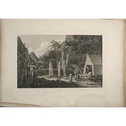
Plate of a Moray on Nukuhiva (Marquesas Islands).
An original plate in imperial folio size, originating from Krusenstern's 1813-14 atlas (Russian & German language) to his voyage around the world: Atlas k puteshestvi...
Place & Date: st. Petersburg, 1813-1814
Selling price: $1650
Sold in 2011
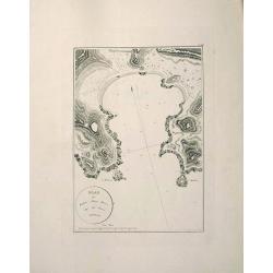
Map of Port Anna Maria (Taiohae Bay) at Nukuhiva, Marquesas Islands.
An original map in imperial folio size with wide margins, originating from Krusenstern's 1813-14 atlas (Russian & German language) to his voyage around the world: Atl...
Place & Date: St. Petersburg, 1813-1814
Selling price: $1450
Sold in 2011
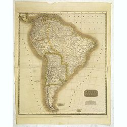
South America.
Map of South America by the Edinburg cartographer John Tomson. Hand colored. Relief shown by hachures.John Thomson was one of the leading masters of the Edinburgh school ...
Place & Date: Edinburgh, London, 1814
Selling price: $65
Sold in 2012
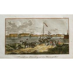
Ansicht von Petersburg, mit dem Marmorpallast.
Rare little view of Saint Petersburg's Marble Palace. With a horse carriage and people in the foreground, and sailing ships on the Neva River. Unusual and decorative i...
Place & Date: unknown, c1814
Selling price: $55
Sold in 2012
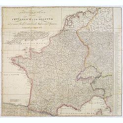
Kriegsschauplatz von ganz Frankreich und Holland.
Rare folding map map of France and the Low Countries published in the year of the defeat of Napoleon. Also including Switzerland and small part of Italy. In Italy the par...
Place & Date: Vienna, 1814
Selling price: $260
Sold in 2013
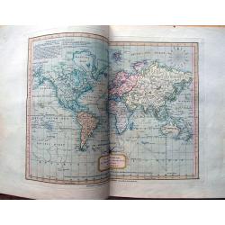
Whittle and Laurie's new and accurate general atlas: chiefly intended for the use of schools, and convenience of gentlemen's libraries: also to accompany the various geographical grammars, dictionaries,...
Unusual Atlas with 39 up-to-date copper engraved maps from the early 19th century. Some maps showing explorers tracks, dates, and annotations. Ninth edition, 1814. With t...
Place & Date: London, 1814
Selling price: $1400
Sold in 2014
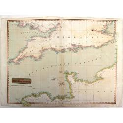
The British Channel.
Fine example of John Thomson’s 1814 map of the English Channel. John Thomson (1777-c1840), was a Scottish cartographer from Edinburgh, celebrated for his 1817 New Gen...
Place & Date: Edinburgh, 1814
Selling price: $26
Sold in 2015
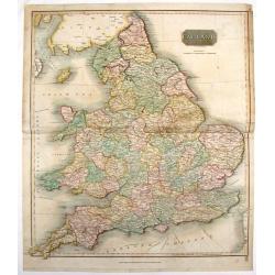
England.
Fine hand-colored, engraved map of England and Wales with Thomson's high level of detail. From "New General Atlas".John Thomson (1777-1840), was a Scottish cart...
Place & Date: Edinburgh, 1814
Selling price: $89
Sold in 2016
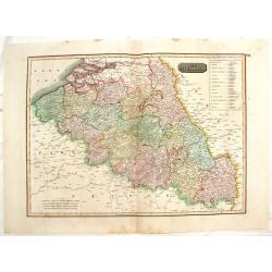
The Netherlands. (Belgium)
Striking, large map of Belgium here called The Netherlands divided into thirteen departments.John Thomson (1777-c1840) was a Scottish cartographer from Edinburgh, celebra...
Place & Date: Edinburgh, 1814
Selling price: $20
Sold in 2016
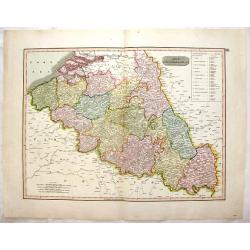
The Netherlands. (Belgium)
This striking hand colored 1814 Thomson map shows modern day Belgium, here called the Netherlands divided into thirteen departments. The labeled the Netherlands or “Low...
Place & Date: Edinburgh, 1814
Selling price: $9
Sold in 2016
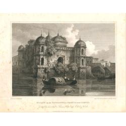
Mosque on the Booragunga Branch of the Ganges.
Mosque on the Booragunga Branch of the Ganges. A British trading post was established at Dacca in East Bengal in the 17th century. The city was a capital of Mughul vicer...
Place & Date: London, 1814
Selling price: $60
Sold in 2020
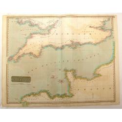
The British Channel.
Fine hand-colored map of the English Channel from John Thomson,s "GENERAL ATLAS" published in 1814. Engraved and signed in print by J & G Menzies.
Place & Date: Edinburgh, 1814
Selling price: $25
Sold in 2016
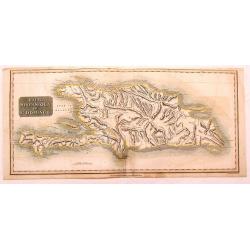
Haiti, Hispaniola or St. Domingo.
Fine Thomson map of Haiti or th island of St. Domingo. Originally paired with the map of Porto Rico, this map has been professionally split into two maps.
Place & Date: Edinburgh, 1814
Selling price: $15
Sold in 2015
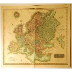
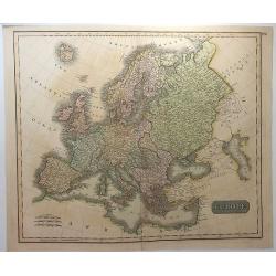
Europe
A very finely engraved, detailed, and attractive early hand colored, 19th century map of Europe, dating from 1814. John Thomson (1777-c1840) was a Scottish cartographer f...
Place & Date: Edinbugh. 1814
Selling price: $89
Sold in 2017
Fowey Haven & C., From a Chart Drawn in the Reign of K. Hen. VIII.
Plan of Fowey Haven. Published by Daniel & Samuel Lysons in 1814. It features views in almost a cartoon style of villages, from a chart of Cornwall, produced during t...
Place & Date: London, 1814
Selling price: $80
Sold in 2017
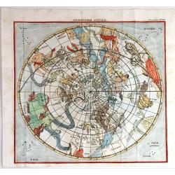
Hemisphere Austral
Striking and highly detailed copper engraved chart showing the constellations located in the Austral Hemisphere. The engraving is the same as Flamsteed's.
Place & Date: Paris, 1814
Selling price: $38
Sold in 2015
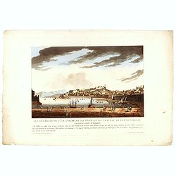
Vue générale de l'île d'Elbe, de la Ville et du château de Porto Ferrajo . . .
This aquatint print figures the town of Porto-Ferrario and it's fortress which was Napoleon's residence during his exile.With address "A Paris chez le Coeur graveur,...
Place & Date: Paris, Le Cœur et Bance ainé, ca 1814
Selling price: $50
Sold in 2016
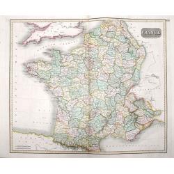
France
A beautiful map of France, engraved and published during Napoleon Bonaparte's time, with stunning color, and magnificent detail. Engraved by Hewitt.
Place & Date: London, ca 1814
Selling price: $12
Sold in 2016
Vue de la ville de Novogorod en Russie . . .
This aquatint print figures a panoramic view of the town of Nizhny Novgorod, located about 400 km east of Moscow, where the Oka empties into the Volga.The city is an impo...
Place & Date: Paris, Le Cœur et Bance ainé, ca 1814
Selling price: $100
Sold in 2016
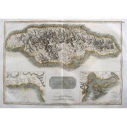
Jamaica.
Large map of the island with insets of 'The Harbour of Bluefields' and 'The Harbours of Kingston and Port Royal'. This map was based on Jefferys' map of 1775. The map is ...
Place & Date: London, 1814
Selling price: $38
Sold in 2017
Hindoostan.
A fine copper engraved map of Hindoostan (now India) drawn and engraved by Alexander Findlay and published by Thomas Kelly, London in 1814
Place & Date: London, 1814
Selling price: $35
Sold in 2017
Europe.
A striking hand colored map of 1814 that depicts Europe one year before Napoleon's defeat at Waterloo in 1815. Thomson's maps are known for their stunning color, large si...
Place & Date: Edinbourgh, 1814
Selling price: $140
Sold in 2018
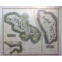
West India Islands - Martinico & Dominica.
A fine example of John Thomson's 1814 map of the West Indian islands of Dominica and Martinique. The map offers detail including individual buildings, villages, hospitals...
Place & Date: Edinbourgh, 1814
Selling price: $20
Sold in 2021
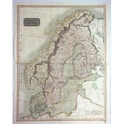
Scandinavia, or Sweden, Denmark & Norway.
A pleasing hand colored 1817 map of Scandinavia; depicting Sweden, Denmark, and Norway. Modern day Finland, though included, was then part of the Kingdom of Sweden. Thoms...
Place & Date: Edinbourgh, 1814
Selling price: $60
Sold in 2019
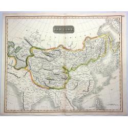
Tartary.
A fine hand colored 1814 Thomson map of central and east Asia, covering southern Tartary, Tibet, Mongolia, and almost all of Central Asia extending from the Caspian Sea t...
Place & Date: Edinbourgh, 1814
Selling price: $20
Sold in 2021
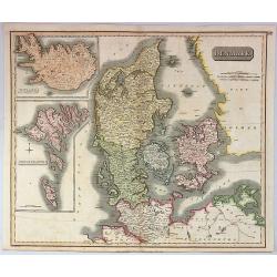
Denmark.
A pleasing, hand colored, 1814 Thomson map that features Denmark, with inserts of Iceland, and the Faeroe Islands. It is engraved in the minimalist English style pioneere...
Place & Date: Edinbourgh, 1814
Selling price: $150
Sold in 2019