Browse Listings
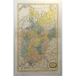
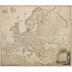
Muscovy or Russia in Europe.
A fine map of western Russia by Brightly & Kinnersly of Suffolk in 1806. Interestingly, the land is called "Russian Lapland", and the Frozen Ocean. Engraved...
Place & Date: Suffolk, 1806
Selling price: $27
Sold in 2018
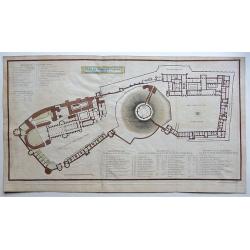
Plan of Windsor Castle MDCCCV.
A very detailed copperplate, plan and gazetteer of Windsor Castle, as it was at the time of The Battle of Trafalgar.Each tower, hall, chamber, ante-room and apartment's n...
Place & Date: London, 1806
Selling price: $200
Sold in 2018
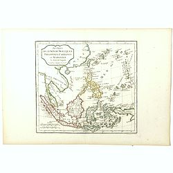
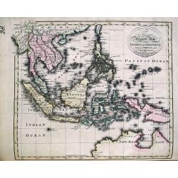
Les Isles de la Sonde, Moluques, Philippines, Carolines et Marianes Par Robert de Vaugondy.
Map of South East Asia. from the atlas Nouvel Atlas Portatif destiné principalement à la jeunesse d'après la Géographie Moderne de l'Abbé Delacroix, published by Fel...
Place & Date: Paris, 1794 - 1806
Selling price: $100
Sold in 2018
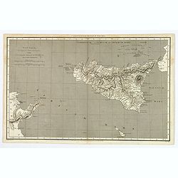
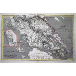
Sicilia, Provincia Romanorum cum Insulis Adjacentibus.
A functional and detailed map of the island of Sicily by Aaron Arrowsmith (1750-1823), an English cartographer, publisher and engraver, and a founding member of the Arrow...
Place & Date: London, 1806
Selling price: $25
Sold in 2020
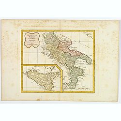
Royaume de Naples et de Sicile.
A map of the Kingdom of Naples, covering the southern part of Italy, with a smaller inset map of Sicily. By C. F. Delamarche, successor of Robert de Vaugondy, a French ge...
Place & Date: Paris, 1794 - 1806
Selling price: $65
Sold in 2020
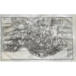
Plan von Lissabon.
Scarce city map of Lisbon. With 54 places named in the panel on the right. Published in Merkwürdigkeiten der Welt by Schrämbl.
Place & Date: Vienna, 1806
Selling price: $70
Sold in 2019
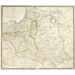
Polen in die dermaligen Besitzungen eingetheilt Nach der vortreflichen Karte von Rizzi Zannoni. . . / Carte de la Pologne. . .
A rare wall map-sized map (more than one meter wide) of Poland and Lithuania set in a decorative frame. The authors of maps, contrary to what the title states, are Schrä...
Place & Date: Vienna, before 1807
Selling price: $2200
Sold
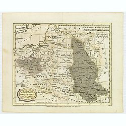
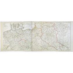
Poland, Shewing the Claims of Austria, Russia, Prussia & Austria from the best Authorities.
Uncommon map of Poland and Lithuania from Rev. E Blomfield's Geography. The atlas was published by C. Brightly & E. Kennersly. Engraved by J. Barlow.
Place & Date: Bungay, Suffolk, 1807
Selling price: $210
Sold in 2012
Hellas sive Graecia propria Thessalia et Epirus...
Interesting map showing a part of Greece during ancient times, extending from Kefalonia and Zakynthos (Zante) Island to Nisos Evvoia. Includes Korfu, parts of Macedonia, ...
Place & Date: London, 1807
Selling price: $2
Sold in 2012
Carte générale du Théâtre de la guerre : comprenant les etats prussiens, la Pologne et tous les pays depuis le Rhin jusqu'en Russie / a Paris 1807 chez Charles Dien, Rue de Jardinet No.13
Scarce map of Poland and eastern Germany. In lower left corner inset map "Carte de la principauté de Neuchatel" (given by Napoleon to Marshal Berthier Louis-Al...
Place & Date: Paris, 1807
Selling price: $1900
Sold in 2014
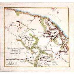
Investissment et Attaque D'York, dans la Virginie.
Engraved fold-out map from the French edition of John Marshall's "Life of George Washington". This historical map depicts Yorktown (the final engagement) and it...
Place & Date: Paris, 1807
Selling price: $29
Sold in 2016
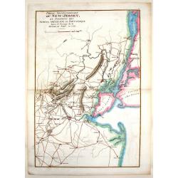
Partie Septentrionale du New-Jersey, et Positions des Armées Américaine et Britannique Après le Passage de la Rivière du Nord, en 1776
Striking and highly detailed Revolutionary War period rare copper engraved map illustrating the military operations of the American Revolution in northern New Jersey duri...
Place & Date: Paris, 1807
Selling price: $96
Sold in 2014
Nouvelle Carte Géographique et des Postes de l'Europe .../ Neueste Post- und General-Karte von Europa ...
A rare wall map of Europe and its Post Roads based on a map by Arron Arrowsmith. Scale ca. 1:3.800.000. Engraved by Johann Spiegl (the younger)Title in German, placed in ...
Place & Date: Vienna, Artaria et Compagnie, 1807
Selling price: $1100
Sold
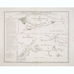
Tableau de l'arrivée de la Flotte Anglaise, dans le Mois de Février 1807, devant Constantinople, et retour de cette même flotte, après 10 jours de présence inutile devant cette ville.
Two maps on one sheet, with an extensive daily description of the mission of Sidney Smith who was sent to join Admiral Sir John Thomas Duckworth's expedition to Constanti...
Place & Date: Paris, ca. 1807
Selling price: $220
Sold in 2018
Empire of Japan. (with Korea)
Detailed map of Japan and including Korea. Japan with good detail, gold mines and more. An island in the Pacific is called "Fatsisio, or Unhappy I. The Place of Exil...
Place & Date: London, 1807
Selling price: $400
Sold in 2020
Carte de la Russie d'Europe dressée par Herisson elève du Cen Bonne. . .
Scarce detailed map of European part of Russia prepared by Eustache Hérisson (b. 1759), engraved by Chamouin, 128 rue de la Bouclerie, Paris. Text engraved by Dien.Accor...
Place & Date: Paris, 1807
Selling price: $425
Sold in 2014
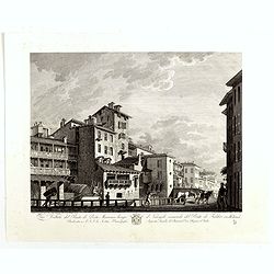
Veduta del Ponte di Porta Marenco lungo il Naviglo, venendo del Ponte de Fabbri in Milano. . .
Showing the bridge of Porta Marenco along the Naviglio Grande coming from the Ponte de' Fabbriin in Milan after a design of Gaspare Galliari (c.1760-1818). With a dedicat...
Place & Date: Milan, 1807
Selling price: $85
Sold in 2014
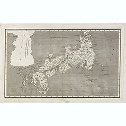
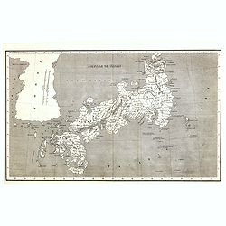
Empire of Japan. (With Sea of Corea)
Detailed map of Japan and including Korea. Japan with good detail, gold mines and more. An island in the Pacific is called "Fatsisio, or Unhappy I. The Place of Exil...
Place & Date: London, 1807
Selling price: $500
Sold in 2023
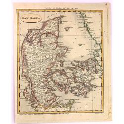
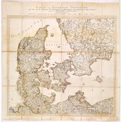
Danimarca.
A fine copper engraved Map of Denmark by Carlo Barbiellini. Engraved by Camiani. It is from "Atlante Delle Geograpfia Antica e Moderna".
Place & Date: Italy, 1807
Selling price: $23
Sold in 2016
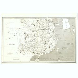
China.
Map of China with Formosa and Strait of Corea. Topographical detail is limited to rivers, lakes, mountains and place names. Sea area shaded. Aaron Arrowsmith, (born July ...
Place & Date: London, 1807
Selling price: $40
Sold in 2017
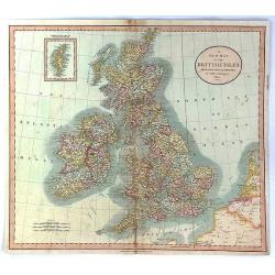
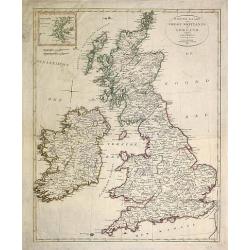
A New Map of the British Isles from the Latest Authorities.
An accurate map of early nineteenth century Great Britain. Two scales at bottom left and title at top right. With an insert of Shetland Islands. All British counties have...
Place & Date: London, 1807
Selling price: $30
Sold in 2017
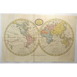
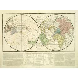
Map of the World from the Best Authorities.
A fine world map by Brightly & Kinnersly of Suffolk in 1807. This double hemispheric map of the world incorporates the discoveries of Captain Cook from the 1780’s. ...
Place & Date: Suffolk, 1807
Selling price: $30
Sold in 2018
![[Titlepage] Atlas Novus Terrarum orbis Imperia..](/uploads/cache/41744-250x250.jpg)
[Titlepage] Atlas Novus Terrarum orbis Imperia..
The decorative title page from Atlas Novus printed by Johann Ernst Udelbulner. Large elaborately engraved sheet with numerous allegorical figures. A large globe, showing ...
Place & Date: Nuremberg 1807
Selling price: $90
Sold in 2018
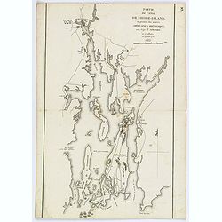
Partie de l'etat de Rhode-Island, et position des armees Americaine et Britannique au Siege de Newport. . .29 Aout 1778.
A nice example of this Revolutionary War battle map showing the siege of Newport on August 29, 1778. It shows the harbour, islands, and opposing encampments. The map acco...
Place & Date: Paris, 1807
Selling price: $44
Sold in 2019
Mappe Monde ou carte Generale de la Terre.
A fine 1807 double hemisphere world map. Published by Blondeau. Continents outlined in color.
Place & Date: Paris, 1807
Selling price: $60
Sold in 2019
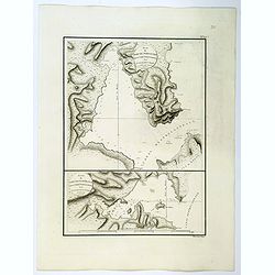
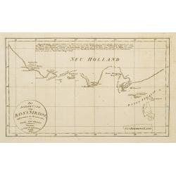
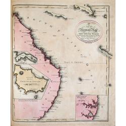
Plan du Port du Nord-Ouest dans le Canal Dentrecasteaux / Plan du Port de L'Esperance. . .
A French maritime charts of the Plan du Port du Nord-Ouest, and Port Esperance both in southern Tasmania, just south of Hobart. This is the edition of the extremely rare ...
Place & Date: Paris, 1807
Selling price: $1200
Sold in 2020
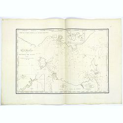
Carte Generale de la partie Meridionale de la Nouvelle Hollande. . .Terre D'Anthony van Diemen. . .
A rarely seen map showing, in great detail, an area of Tasmania explored by Admiral Bruny-Dentrescasteaux. The expedition to search for the lost expedition of La Perouse ...
Place & Date: Paris 1807
Selling price: $600
Sold in 2019
Carte Particuliere du canal Dentrecasteaux entre la Terre Meridionale d'Anthony van Diemen. . .
A lovely chart of the southeast coast of Tasmania from South Cape to North Bay, which includes the present site of Hobart. These charts are strikingly beautiful & acc...
Place & Date: Paris 1807
Selling price: $800
Sold in 2019
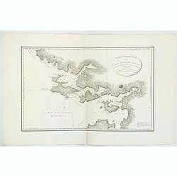
Carte Generale du Detroit de Bass. . .
A highly detailed chart of the waters between Victoria on the mainland of Australia and the island of Tasmania, (Bass Strait) published by expedition member Louis Claude ...
Place & Date: Paris 1807
Selling price: $600
Sold in 2019
(Two copies of ) Nieuwe kaart van Groot Brittanje en Ierland.
Uncommon map of England and Ireland, printed by François Bohn in Haarlem, who was active from 1786 till 1819. Engraved by C.van Baarsel.
Place & Date: Haarlem 1807
Selling price: $50
Sold in 2013
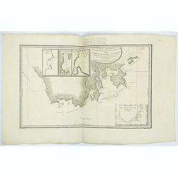
Die Nordküste von Bas's Strasse aufgenomen.
Map of the south east coast of Australia, with the northern tip of van Diemens land. According to the title cartouche the map was drawn by Lieuth. Jac Grant in December 1...
Place & Date: Weimar 1807
Selling price: $162
Sold
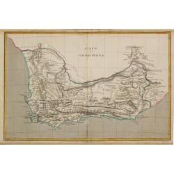
Cape of Good Hope.
Aaron Arrowsmith (1750-1833) , London-based, prolific cartographer and publisher, Hydrographer to His Majesty (1820).Map of the colony of the Cape of Good Hope. The bound...
Place & Date: London, 1807
Selling price: $125
Sold
![[Titlepage] Atlas Methodicus explorandis juvenum profectibus in Studio Geographico..](/uploads/cache/22365-250x250.jpg)
[Titlepage] Atlas Methodicus explorandis juvenum profectibus in Studio Geographico..
Taken from title page from Atlas methodicus explorandis juvenum profectibus in studio geographico ad methodum Hubnerianam accommodatus, a Johanne Baptista Homanno, Sacrae...
Place & Date: Nuremberg 1807
Selling price: $200
Sold
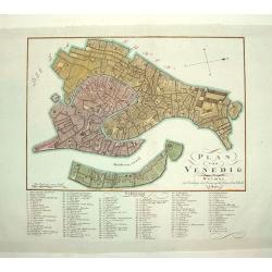
PLAN VON VENEDIG
An uncommon and finely rendered plan of Venice. The work is highly detailed and provides a 133 point legend identifying the town's key sites and places of import.Seldom s...
Place & Date: Weimar, Germany, dated 1807
Selling price: $350
Sold
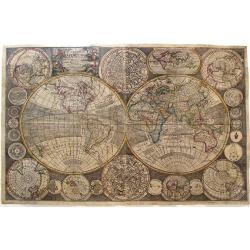
Hémisphere maritime Hémisphere Terrestre.
Uncommon map with two world projections, with underneath seven text blocks in French.The colored lines are according to the color key showing the tracks of Marco Polo, An...
Place & Date: Florence, M. Landi, 1807
Selling price: $250
Sold in 2011

Veduta del Mausoleo d'Elio Adriano (ora chiamato Castello S.Angelo) nella parte opposta alla Facciata dentro al Castello.
Fine early imprint and signed in the plate in lower right corner : Piranesi Archit.dis. ed inc.. In the center Presso l'Autore a Strada Felice vicino alla Trinità de'Mon...
Place & Date: First Paris edition, 1800?1807
Selling price: $1300
Sold
Carte Des Isles De Saint Pierre Et Miquelon..
A well engraved and highly detailed chart showing the islands Miquelon and St. Pierre with superb detail of the islands, soundings and anchorages. The chart is embellishe...
Place & Date: Paris 1763-1807
Selling price: $500
Sold
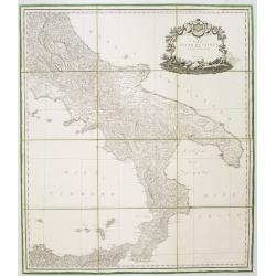
Carta del Regno di Napoli Indicante la divisione delle XIV sue provincie.
Separately published wall map of the southern part of Italy. Engraved by Vincenze Aloja and published by Rizzi Zanoni. The map representation is by Cassini with the Prime...
Place & Date: Naples, 1807
Selling price: $375
Sold in 2008
![[Map of Asia]](/uploads/cache/29686-250x250.jpg)
[Map of Asia]
Map of the continent of Asia with in the lower right corner the continent of Australia, labeled "Nouvelle Hollande", with only "Botany Bay" mentioned....
Place & Date: Paris, 1807
Selling price: $360
Sold
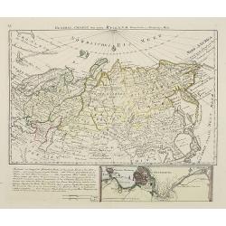
General Charte von ganz Rusland, Europaischer u. Asiatischer Theil.
Very rare map of Russia, with in lower part an inset of S.Petersburg (67x210mm) . From "Neuer Hand- und Staats-Atlas von Europa".The map is of interest for the ...
Place & Date: Leipzig, 1807
Selling price: $1800
Sold
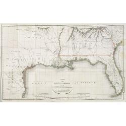
Carte des deux Florides et de la Louisiane inférieure : dressee pour les voyages de Mr. Robin dans les annees 1802, 1803, 1804, 1805 et 1806. . .
Very detailed map by J.B. Poirson, which shows all of Florida and Georgia, Louisiana north to Arkansas with the Ozarks clearly delineated, and east Texas with its rivers ...
Place & Date: Paris, F. Buisson,1807
Selling price: $550
Sold in 2010
![[Titlepage] Atlas Novus Terrarum orbis Imperia..](/uploads/cache/45629-250x250.jpg)
[Titlepage] Atlas Novus Terrarum orbis Imperia..
The decorative title page from Atlas Novus printed by Johann Ernst Udelbulner. Large elaborately engraved sheet with numerous allegorical figures. A large globe, showing ...
Place & Date: Nuremberg 1807
Selling price: $210
Sold in 2020
![[Part of a wall map of Hungary].](/uploads/cache/42560-250x250.jpg)
[Part of a wall map of Hungary].
The Upper left corner of the large folding wall map of Hungary was prepared by Ignac Müller and published first in 1769. The map was made for official use and was kept ...
Place & Date: Vienna, T.Mollo, 1769 - 1807
Selling price: $75
Sold in 2023

Ours blanc du nord. Dessine d'apres nature par Huet fils peintre de la menagerie de sa majeste. . .
A very rare and large print of a polar bear. From a series of images of the zoological garden "Jardin des Plantes" which also included a "Menagerie". ...
Place & Date: Paris, ca 1808
Selling price: $160
Sold in 2020
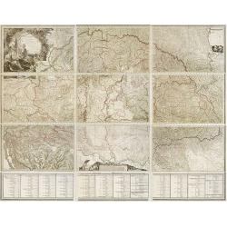
Die Baierische Monarchie. Entworfen in zwey Blättern von Conrad Mannert.
First edition of this important folding map of Southern Germny prepared by Professor Conrad Mannert. The map was kept simple despite its relatively large scale and saw a ...
Place & Date: HOMANN HEIRS, Nuremberg, 1808
Selling price: $100
Sold in 2021
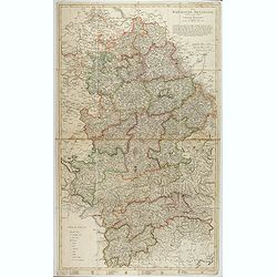
Mappa Generalis regni Hungariae partiumque adnexarum Croatiae, Slavoniae et Confiniorum Militarium Magni item PrincipatusTransylvaniae geometricis partium dimensionibus, recentissimisque astronomicis observationibus. . .
The map has been engraved by G. and F. Prixner Karacs. The map itself is on 9 sheets, measuring approx. 138 x 213 cm. Underneath with 3 sheets (each 27 cm high) with admi...
Place & Date: Vienna, 1808
Selling price: $1500
Sold in 2012
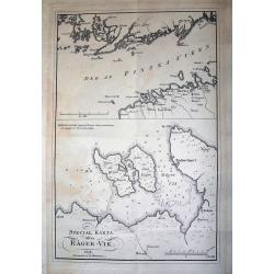
SPECIAL KARTA ösver RÄGER-VIK
Rare page with two maps. The map on top showing the coasts of Estonia and Finland at the Finnish sea bosom. Includes the city of Tallinn (Revel). The map below is a lar...
Place & Date: Stockholm, 1808
Selling price: $55
Sold in 2012
Karte vom Königreichs Daenemark nach den von der Akademie der Wissenschaften zu Kopenhagen harausgegebenen Special Karten. . .
Uncommon folding map of Denmark and part of Sweden and Germany. A road system has been drawn in.More about folding maps. [+]
Place & Date: Berlin, ca. 1808
Selling price: $50
Sold in 2013
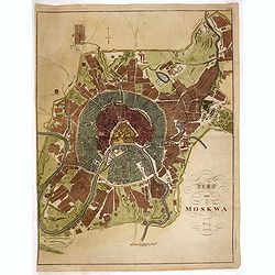
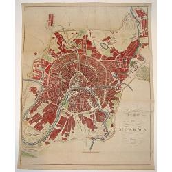
Plan von Moskwa . . . 1808
Rare plan of Moscow, Scale ca. 1:11,850. Relief shown by hachures. With in upper right corner "Taf: XVII." Uncommon bird's-eye plan of Moscow centered on the Kr...
Place & Date: Prague, 1808
Selling price: $1000
Sold in 2014
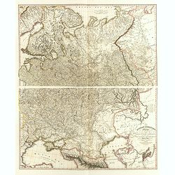
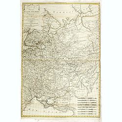
The Russian Dominions in Europe, drawn from the latest Maps, printed by the Academy of Sciences, St. Petersburg; revised and corrected, with the Post Roads. . .
A two-sheet map of Russia covering from the Arctic Sea to the Black and Caspian Seas and from East Prussia and Moldova to the Aral Sea and Tobolsk. Modern day nations of ...
Place & Date: London, June, 1808
Selling price: $750
Sold in 2014
A New and Accurate Map of the Islands and Channels between China and New Holland.
Very rare copper-engraved map from Thomas Brown's General Atlas (1801 or 1808). The map extends from Burma to Taiwan with parts of China, and south to Australia, includin...
Place & Date: Edinburgh, 1801-1808
Selling price: $450
Sold in 2015
A New and Accurate Map of New South Wales...
Interesting map of eastern Australia, published by Thomas Brown. It includes 3 inset maps of Norfolk Island, Lord Howe Island, and Port Jackson with Botany Bay! Shows als...
Place & Date: Edinburgh, 1801-1808
Selling price: $400
Sold in 2014
A New Map of the World with all the New Discoveries, By Captain Cook & other Navigators Includes the Trade Winds, Monsoons and Variations of the Compass. . .
ONLY RECORDED COPY Rare separately issued broadside map, published in London by George Thompson and dated Jan. 1st, 1808. A two-sheet (655x975mm.) double-hemisphere map o...
Place & Date: London, 1798 but here dated 1808
Selling price: $2275
Sold in 2015

Germany.
Pleasant engraved map of Germany and Poland. Engraved by Neele and published in London in 1808 by Longman & Co.
Place & Date: London, 1808
Selling price: $17
Sold in 2016
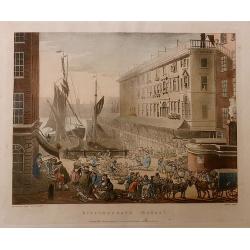
Billingsgate Market, from the Microcosm of London.
A beautiful first edition colored aquatint view of ‘old’ Billingsgate Market, early in the 19th century, where fresh fish were landed and sold directly on the docksid...
Place & Date: London, 1808
Selling price: $100
Sold in 2017
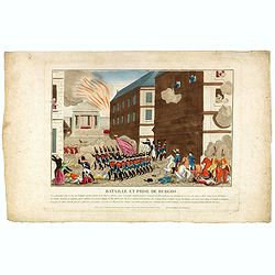
Bataille et prise de Burgos.
Print published in "Paris chez la Ve. Chéreau M.de d'estampes, rue St. Jacques N°10, aux deux Colonnes, près la Fontaine St. Séverin". The text below the pr...
Place & Date: Paris, Vve. Chéreau, ca 1808
Selling price: $40
Sold in 2016
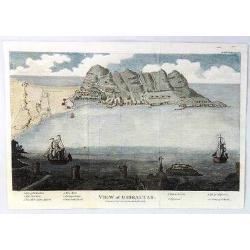
A View of Gibraltar
An interesting view of Gibraltar by J.F. Bourgoing, including a birds-eye view from the water and a view at the bottom looking out to sea featuring two sailing vessels.Te...
Place & Date: London, 1808
Selling price: $24
Sold in 2020
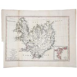
Charte von Island und den Faroer-Inseln.
An edition of this scarce map of Iceland, by an anonymous publisher in Prague.It shows excellent detail in the interior of the Island, including political subdivisions, t...
Place & Date: Prague, 1808
Selling price: $120
Sold in 2021
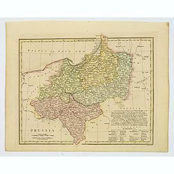
Prussia.
An attractive map with full original color from Wilkinson's General Atlas of the World, Quarters, Empires, Kingdoms, States &c. with Appropriate Tables published by R...
Place & Date: London, 1808
Selling price: $1
Sold in 2021
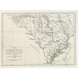
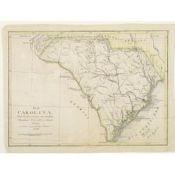
Süd Carolina. Nach des Gouverneurs von Carolina J. Dalton Charte (1803) reducirt. . .
Interesting map of South Carolina and its cartographic source, based on Governor Drayton's map of South Carolina of 1803. The map provides lots of details with many place...
Place & Date: Weimar, Geographisches Institute, 1808
Selling price: $300
Sold in 2018

Le Quadricolor.
Very decorative plate from Histoire naturelle des oiseaux d'Afrique , published by Delachaussée. Levaillant's interest in natural history led him to explore Africa as th...
Place & Date: Paris 1796-1808
Selling price: $120
Sold in 2008

Le Bacbakiri.
Very decorative plate from Histoire naturelle des oiseaux d'Afrique , published by Delachaussée. After Reinold and engraved by Claude Fessard.Levaillant's interest in na...
Place & Date: Paris, 1796-1808
Selling price: $100
Sold in 2016
Map von Moskwa.
A scarce bird's-eye plan of Moscow was published in Prague, possibly in cooperation with military sources. The work centers on the Kremlin and provides fine detailing of ...
Place & Date: Prague, dated 1808
Selling price: $350
Sold
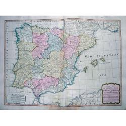
A New Map of the Kingdoms of Spain and Portugal...
Attractive map of the Iberian Peninsula, including the Balearic Islands, parts of north Africa, and south France. Very detailed map with many place names, main roads, a l...
Place & Date: London, 1808
Selling price: $81
Sold in 2012
Karta öfver Syd Westra delen af Öster Sjön..
Map centred on the south-western part of the Baltic Sea, namely on the Isles of Fyn and Sjaelland in Denmark. It gives also good detail of the southern coast of Germany a...
Place & Date: Stockholm 1808
Selling price: $200
Sold
Karta öfver Kettegat och Bohus Bugten med en del af Skagerrack..
Chart encompassing the part of the North Sea between the Kattegat and the Skagerrak straits.It gives good detail of the Jutland seacoast as well as part of Norway and the...
Place & Date: Stockholm, 1808
Selling price: $100
Sold in 2011
Süd Carolina. Nach des Gouverneurs von Carolina..
Map of South Carolina. Copied after a map by J.Drayton.
Place & Date: Weimar, 1808
Selling price: $340
Sold
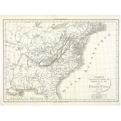
Carte des Etats du centre, de L'Quest et du Sud des Etats-Unis.
Detailed map of the East Coast of America, taken from "Voyage à l'Ouest des Monts Alléghanys, dans les Etats de l'Ohio, du Kentucky et du Tennessée, et retour à ...
Place & Date: Paris, Dentu, 1808
Selling price: $400
Sold in 2015

Le Piacpiac.
Very decorative plate from Histoire naturelle des oiseaux d'Afrique , published by Delachaussée. Levaillant's interest in natural history led him to explore Africa as th...
Place & Date: Paris, 1796-1808
Selling price: $65
Sold in 2020

Le Minule.
Very decorative plate from Histoire naturelle des oiseaux d'Afrique , published by Delachaussée. Levaillant's interest in natural history led him to explore Africa as th...
Place & Date: Paris, 1796-1808
Selling price: $120
Sold in 2018

La Pie Rousse.
Very decorative plate from Histoire naturelle des oiseaux d'Afrique , published by Delachaussée. Levaillant's interest in natural history led him to explore Africa as th...
Place & Date: Paris, 1796-1808
Selling price: $80
Sold in 2016

Le Sieriner. Planche 82.
Very decorative plate from Histoire naturelle des oiseaux d'Afrique , published by Delachaussée. Levaillant's interest in natural history led him to explore Africa as th...
Place & Date: Paris, 1796-1808
Selling price: $100
Sold in 2008
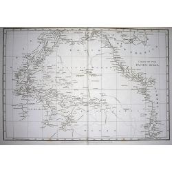
Chart of the Pacific Ocean.
Very interesting map of the Pacific Ocean. Shows the tracks and dates of Captain Cook's voyages! (and also Clarke and Furneaux). Shows Australia with unfinished coast li...
Place & Date: London, 1808
Selling price: $210
Sold in 2009
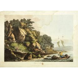
View in Queen charlotte's sound, New Zealand.
Early view of Queen charlotte's sound, taken from "Views in the South Seas" being a very important and early views depicting scenes encountered while employed a...
Place & Date: London, Boydell and Co., 1808
Selling price: $2200
Sold in 2019

The plantain tree, in the island of Cracatoa.
The plantain tree, in the island of Cracatoa, taken from "Views in the South Seas" being a very important and early views depicting scenes encountered while emp...
Place & Date: London, Boydell and Co., 1808
Selling price: $1500
Sold in 2010
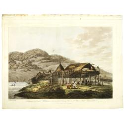
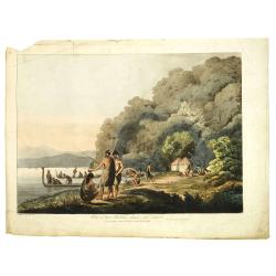
Balagans or summer habitations, with the method of drying fish at St. Peter and Paul, Kamtschatka.
Balagans or summer habitations, with the method of drying fish at St. Peter and Paul, Kamtschatka, taken from "Views in the South Seas" being a very important a...
Place & Date: London, Boydell and Co., 1808
Selling price: $1200
Sold in 2017
View in Macao, including the residence of camoens, when he wrote his Lusiad.
One of two views of Macao, taken from "Views in the South Seas" being a very important and early views depicting scenes encountered while employed as draughtsma...
Place & Date: London, Boydell and Co., 1808
Selling price: $4200
Sold in 2010
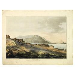
View in Macao.
Early view of Macao, taken from "Views in the South Seas" being a very important and early views depicting scenes encountered while employed as draughtsman on C...
Place & Date: London, Boydell and Co., 1808
Selling price: $2900
Sold in 2012
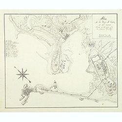
Plan de la baye de Cadiz et des environs Dressé en 1808 par ordre de l'amiral Rosillef
Anonymous pen and ink drawing with a lettered key (A-O) in left part. The Capture of the Rosily Squadron took place on 14 June 1808, in Cadiz, Spain, nearly three years a...
Place & Date: ca. 1808
Selling price: $425
Sold in 2011
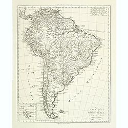
Amérique méridionale. . .
Detailed map of South of America. Includes a cartouche for the Galapagos island.Jean Baptiste Poirson (1760-1831) was a French geographer and engineer.
Place & Date: Paris, 1808
Selling price: $30
Sold in 2011