Browse Listings
A Chart of the Braces at the Entrance of the Ganges or River...
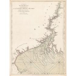
A Chart of the Braces at the Entrance of the Ganges or River of Hughly with the Course of that River up to the Town of Hughly. Improved from Mr. d’Anville’s Chart of ...
Date: London, 1778
Selling price: ????
Please login to see price!
Sold in 2023

A new & accurate map of Asia, Drawn from the most approved modern maps & charts / by Thos. Bowen.
The map is of interest for the use of Sea of Korea, the sea between Korea and Japan.Detailed map of Asia from Saudi Arabia, Persia, Russia, India, China, Japan to Southea...
Date: London, J.Cooke, 1777-1778
Selling price: ????
Please login to see price!
Sold in 2023
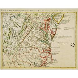
Il Maryland, il Jersey Meridionale la Delaware e la..
Attractive map covering Baltimore, Washington DC, North Carolina. In the north Philadelphia and in the south to New Bern. From Zatta's Atlante Novissimo.
Date: Venice 1778
Selling price: ????
Please login to see price!
Sold
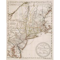
Special Karte von den Mittleren Brittischen Colonien..
Uncommon German map of the east coast of North America. Engraved by T.A.Pingeling. From Bescheibung des brittischen Amerika by Christian Leiste.
Date: Wolfenbüttel 1778
Selling price: ????
Please login to see price!
Sold
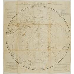
Charte von der Südlichen halbkugel..
This south polar view of the world details the tracks of Cook's voyages by (Johann) Georg (Adam) Forster (1754-1796) who carried out his father's ambition to publish the ...
Date: Berlin 1778
Selling price: ????
Please login to see price!
Sold
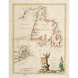
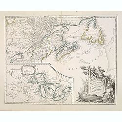
Le Isole di Terra Nuova e Capo Breton .
Newfoundland and Cape Breton. The title vignette shows fish being dried, an indication of the importance of the fishing industry there. Published in Zatta's "Atlante...
Date: Venice 1778
Selling price: ????
Please login to see price!
Sold
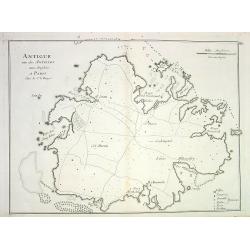
Antigue une des Antilles aux Anglois...
Detailed copper-engraved chart of Antigua, showing ports, anchor spots, reefs, roads, forts and towns. With key and distance scale.
Date: Paris, 1778
Selling price: ????
Please login to see price!
Sold in 2008
A new & Correct Chart shewing.. Bay of Bengalen..
Important chart of the Bay of Bengal. In upper part inset map of river Ganges. From East India Pilot . Detailed map with compass roses and system of rhumb lines, sounding...
Date: London 1778
Selling price: ????
Please login to see price!
Sold
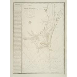
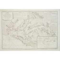
Plan de la Riviere du Cap Fear depuis la Barre jusques a Brunswick?. (Cape Fear)
A well engraved and highly detailed chart that was issued in Neptune Americo-Septentrionale. This chart is based on Sayer & Bennett's chart that was issued in 1776 an...
Date: Paris 1778
Selling price: ????
Please login to see price!
Sold
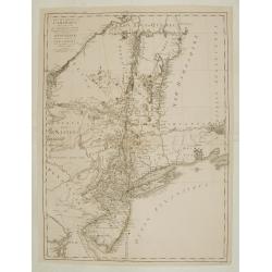
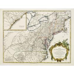
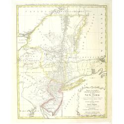
Carte des troubles De L'Amerique..New-York.. Jersey..
A French edition of this uncommon map giving good detail of the states of New York and New Jersey. Claude Joseph Sauthier was a German surveyor from Strasbourg who immigr...
Date: Paris 1778
Selling price: ????
Please login to see price!
Sold
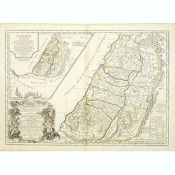
Carte de la terre des Hébreux / La Monarchie des Hébreux..
Two maps of the Holy Land on one sheet. Engraved by the master G.Delahaye and prepared by N.Sanson. In title cartouche lower left Moses and Aaron.
Date: Paris, 1778
Selling price: ????
Please login to see price!
Sold
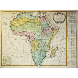
L?Afrique divisée en ses principaux Empires et Royaumes.
Gilles Robert de Vaugondy (!686-1766) and son Didier (1723-86), Paris geographers and publishers. Gilles succeedded Pierre Moulart Sanson in 1730. ' Atlas Portatif', 1748...
Date: Paris, Fortin, 1778
Selling price: ????
Please login to see price!
Sold in 2008
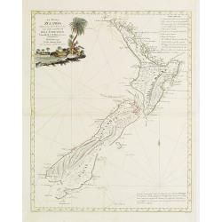
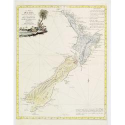
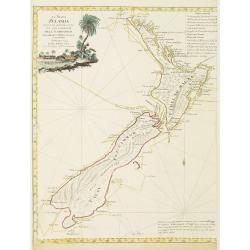
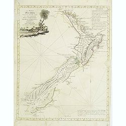
La Nuova Zelanda tracorsa nel 1769 e 1770 dal Cook commandante dell' Endeavour Vascello di S.M.Britannica.
Antonio Zatta?s map of New Zealand is not only one of the first to show the results of Cook?s voyages, but is also one of the most attractive of the islands. Considerable...
Date: Venise 1778
Selling price: ????
Please login to see price!
Sold
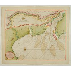
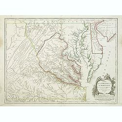
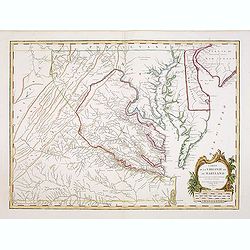
Carte de la Baie de Chesapeake et de la Partie navigable des Rivieres, James, York, Patowmack, Patuxen, Patapsco, North-East, Choptank et Pokomack... par ordre de M. de Sartine.
A French version of Anthony Smith's important and detailed chart of the Chesapeake and surrounding waterways. The first edition was entitled "A New and Accurate Char...
Date: Paris 1778
Selling price: ????
Please login to see price!
Sold
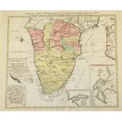
Africae Pars Meridionalis cum Promontorio Bonae Spei Accuratissime Delineato
A map of Southern Africa by T.Lotter [1717-1777]. The coastline still provides inaccurate information, while Hottentot tribes are illustrated throughout the mainland. The...
Date: Vienna, 1778
Selling price: ????
Please login to see price!
Sold
La Nuova Zelanda tracorsa nel 1769 e 1770 dal Cook commandante dell' Endeavour Vascello di S.M.Britannica.
Antonio Zatta?s map of New Zealand is not only one of the first to show the results of Cook?s voyages, but is also one of the most attractive of the islands. Considerable...
Date: Venise 1778
Selling price: ????
Please login to see price!
Sold
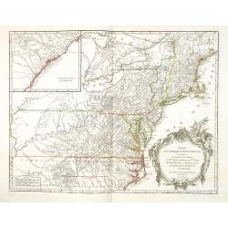
Partie de l'Amerique septentrionale.. le cours de L'Ohio..
From the Atlas Universel , a detailed map extending the length of the east coast from Penobscot Bay to Cape Fear and, in an inset, from Cape Fear to Fort St.Georges.This ...
Date: Paris (1755) 1778
Selling price: ????
Please login to see price!
Sold
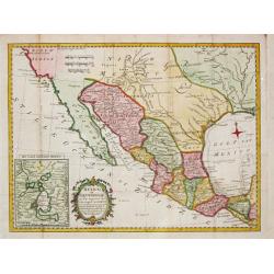
Mexico of Nieuw Spanje.
A map of Mexico and Texas ( called Tecas) from the Dutch edition of Robertson's ' History of America'.
Date: Amsterdam, 1778
Selling price: ????
Please login to see price!
Sold in 2018
La Nuova Zelanda tracorsa nel 1769 e 1770 dal Cook commandante dell' Endeavour Vascello di S.M.Britannica.
Antonio Zatta?s map of New Zealand is not only one of the first to show the results of Cook?s voyages, but is also one of the most attractive of the islands. Considerable...
Date: Venise, 1778
Selling price: ????
Please login to see price!
Sold in 2008
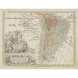
America Meridionalis per sua regna provinc: et Ins. . .
Miniature map of South America, showing the continent too narrowly and the Salomon Islands too near to South America. The coastline is surrounded with place names. Routes...
Date: Augsburg, J.M.Will, 1778
Selling price: ????
Please login to see price!
Sold in 2012
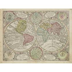
Diversi Globi Terr-Aquei Statione Variante et Visu Intercedente per Coluros Tropicorum. . .
Map of the world in two hemispheres, with smaller celestial spheres and diagrams of the solar system according to Ptolemy, Tycho Brahe, Copernicus and Descartes.From Atla...
Date: Augsburg, J.M.Will, 1778
Selling price: ????
Please login to see price!
Sold in 2010
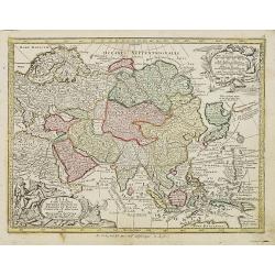
Asia cum omnibus Imperiis Provinciis . . .
Miniature map of Asia, a reduction of Seutter's folio map.From Atlas Minor, here published by Johann Martin Will, with his address in bottom center of the map.The cartouc...
Date: Augsburg, J.M.Will, 1778
Selling price: ????
Please login to see price!
Sold in 2018
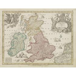
Accuratiffima Angliae Scotiae et Hiberniae. . .
Miniature map of the United Kingdom with Scotland and Ireland, a reduction of Seutter''s folio map.From Atlas Minor, here published by Johann Martin Will, with his addres...
Date: Augsburg, J.M.Will, 1778
Selling price: ????
Please login to see price!
Sold in 2023
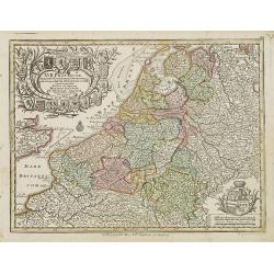
XVII Provinciae Belgii five Germaniae inferioris. . .
Miniature map of the Belgium, Luxemburg, the Netherlands, a reduction of Seutter''s folio map.From Atlas Minor, here published by Johann Martin Will, with his address in ...
Date: Augsburg, J.M.Will, 1778
Selling price: ????
Please login to see price!
Sold in 2008
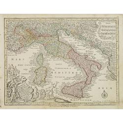
Nova totius Italiae cum adjecentibus majoribus et minorib Insulis. . .
Miniature map of Italy, a reduction of the appropriate part of Seutter''s folio map of the Americas, drawn by Albert Seutter. An unusual looking map, its projection givin...
Date: Augsburg, J.M.Will, 1778
Selling price: ????
Please login to see price!
Sold in 2022
Regni Hungariae. . .
Miniature map of Hungary.From Atlas Minor, here published by Johann Martin Will, with his address in bottom center of the map.The cartouche is left uncolored in order to ...
Date: Augsburg, J.M.Will, 1778
Selling price: ????
Please login to see price!
Sold in 2022
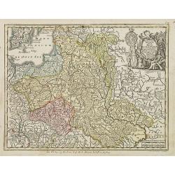
Polonia regnum ut et magni Ducat Lithuania. . .
Miniature map of Poland, a reduction of the appropriate part of Seutter's folio map. Engraved by Tobias Conrad Lotter.From Atlas Minor, here published by Johann Martin Wi...
Date: Augsburg, J.M.Will, 1778
Selling price: ????
Please login to see price!
Sold in 2009
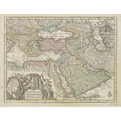
Magni Turcarum dominatoris Imperium . .
Uncommon version of this small map of the Ottoman Empire extending from the Balkans and the north African coast through Arabia the Black Sea. Decorated with a small compa...
Date: Augsburg, J.M.Will, 1778
Selling price: ????
Please login to see price!
Sold in 2008
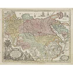
Imperium Russiae Magnae. . .
Miniature map of Russia, a reduction of the appropriate part of Seutter's folio map.From Atlas Minor, here published by Johann Martin Will, with his address in bottom cen...
Date: Augsburg, J.M.Will, 1778
Selling price: ????
Please login to see price!
Sold in 2008
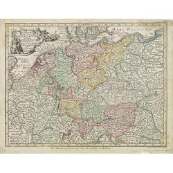
Imperium Romano Germanicum. . .
Miniature map of the German Empire, a reduction of Seutter''s folio map.From Atlas Minor, here published by Johann Martin Will, with his address in bottom center of the m...
Date: Augsburg, J.M.Will, 1778
Selling price: ????
Please login to see price!
Sold in 2008
![[Title page] Atlas Minor. . .](/uploads/cache/25496-250x250.jpg)
[Title page] Atlas Minor. . .
Title page set in a beautiful cartouche with mythological figures and putti surrounding a globe highlighting Europe and Africa from the Atlas Minor, here published by Tob...
Date: Augsburg, J.M.Will, 1778
Selling price: ????
Please login to see price!
Sold in 2008
Kaart van de Golf van Mexico, de Eilanden en de Aangrenzende Landschappen.
A map of the Caribbean from the Dutch edition of Robertson''s "History of America".
Date: Amsterdam, 1778
Selling price: ????
Please login to see price!
Sold in 2019

Carte de la Dominique prise par les François Le 7 septembre 1778. . .
A rare, one of the finest maps of Dominica ever produced, with insets of Charlottesville with its attack by the French on 7 September 1778. Also small inset map of the Ca...
Date: Paris, 1778
Selling price: ????
Please login to see price!
Sold
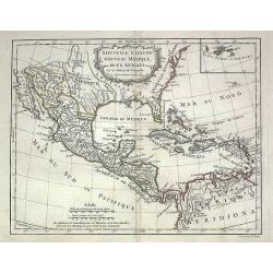
Nouvelle Espagne, Nouveau Mexique, Isles Antilles
Map of the 18th century Spanish territories of New Spain and New Mexico together with islands of the Caribbean. Accurate coastlines and good delineation of the rivers alo...
Date: Paris, 1778
Selling price: ????
Please login to see price!
Sold in 2009
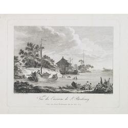
Vue des environs de St. Petersbourg.
Engraved by de Menchy after a drawing made after nature by Le Prince.
Date: Paris, 1778
Selling price: ????
Please login to see price!
Sold in 2009
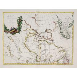
La Baja D'Hudson Terra di Labrador e Groenlandia.
Decorative map of Nova Scotia, Hudson Bay and part of Greenland. With many names of villages, as well engraved mountains and rivers are shown.Published in Zatta's "A...
Date: Venice, 1778
Selling price: ????
Please login to see price!
Sold in 2009
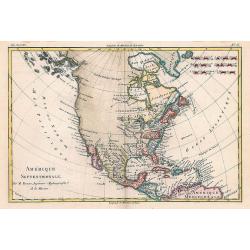
Amérique Septentrionale.
Interesting copper-engraved map of North America with Central America, the Caribbean, and parts of South America. Shows large unexplored blank parts in nowadays Western ...
Date: Paris, c1778
Selling price: ????
Please login to see price!
Sold in 2010
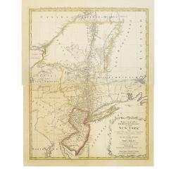
Mappa geographica Provinciæ Nova Eboraci ab Anglis New-York dictæ ex ampliori delineatione ad exactas dimensiones concinnata in arctius spatium redacta cura Claudii Josephi Sauthier cui accedit Nova Jersey ex topographicis observationibus.
Homann Heirs' edition of Sauthier's celebrated map of New York and New Jersey, made during the Revolutionary War. Also shows portions of Pennsylvania and New England. Rel...
Date: Nuremburg, 1778
Selling price: ????
Please login to see price!
Sold in 2018
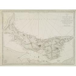
Plan de L'ile de St. Jean Au nord de l'Acadie. . .
Chart of Prince Edward Island with Charlotte town. Named after Queen Charlotte, the wife of George III.After Dutch and British sources. Engraved by Petit and edited by th...
Date: Paris, 1778
Selling price: ????
Please login to see price!
Sold in 2010

Le Cap-ne. Jacques Cook ...
From the French edition of James Cook's second voyage entitled Voyage dans l'Hémisphère Austral, et autour du Monde, fait sur les Vaissseaux de Roi, l'Aventure, la Rés...
Date: Paris, 1778
Selling price: ????
Please login to see price!
Sold in 2010
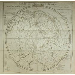
Carte de l'Hemisphere Austral.
From the French edition of James Cook's second voyage entitled Voyage dans l'Hémisphère Austral, et autour du Monde, fait sur les Vaissseaux de Roi, l'Aventure, la Rés...
Date: Paris, 1778
Selling price: ????
Please login to see price!
Sold in 2010
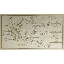
Plan de le Baye Dusky (Obscure) à la Nouv-e. Zélande.
From the French edition of James Cook's second voyage entitled Voyage dans l'Hémisphère Austral, et autour du Monde, fait sur les Vaissseaux de Roi, l'Aventure, la Rés...
Date: Paris, 1778
Selling price: ????
Please login to see price!
Sold in 2010

Plante de Lin de la Nouvelle Zélande.
From the French edition of James Cook's second voyage entitled Voyage dans l'Hémisphère Austral, et autour du Monde, fait sur les Vaissseaux de Roi, l'Aventure, la Rés...
Date: Paris, 1778
Selling price: ????
Please login to see price!
Sold in 2010
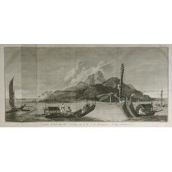
L'Isle d'Otahiti ...
From the French edition of James Cook's second voyage entitled Voyage dans l'Hémisphère Austral, et autour du Monde, fait sur les Vaissseaux de Roi, l'Aventure, la Rés...
Date: Paris, 1778
Selling price: ????
Please login to see price!
Sold in 2010

Débarquement à Tanna ...
From the French edition of James Cook's second voyage entitled Voyage dans l'Hémisphère Austral, et autour du Monde, fait sur les Vaissseaux de Roi, l'Aventure, la Rés...
Date: Paris, 1778
Selling price: ????
Please login to see price!
Sold in 2010

Fig.1. Observatoire portatif. Fig.2. Maniere d'atablir une Horloge Astronomique à terre.
From the French edition of James Cook's second voyage entitled Voyage dans l'Hémisphère Austral, et autour du Monde, fait sur les Vaissseaux de Roi, l'Aventure, la Rés...
Date: Paris, 1778
Selling price: ????
Please login to see price!
Sold in 2010
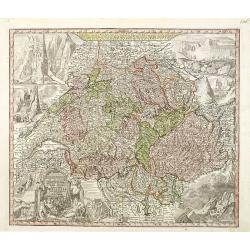
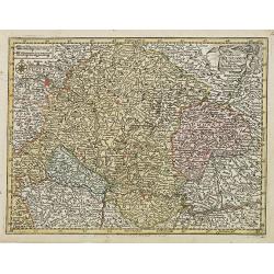
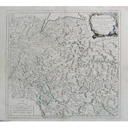
Nova Totius Helvetiae cum suis subditis ac sociis tab. Geogr. . .
Detailed map of Switzerland divided up it its cantons. This one of the most decorative maps of Switzerland published in the eighteenth century, with many engraved place n...
Date: Augsburg, 1778
Selling price: ????
Please login to see price!
Sold in 2011
Mappa geographica Provinciæ Nova Eboraci ab Anglis New-York dictæ ex ampliori delineatione ad exactas dimensiones concinnata in arctius spatium redacta cura Claudii Josephi Sauthier cui accedit Nova Jersey ex topographicis observationibus.
Homann Heirs' edition of Sauthier's celebrated map of New York and New Jersey, made during the Revolutionary War. It also shows portions of Pennsylvania and New England. ...
Date: Nuremberg, 1778
Selling price: ????
Please login to see price!
Sold in 2011
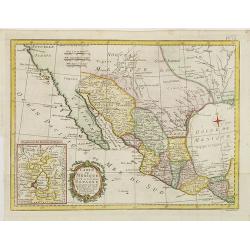
Carte du Mexique ou de la nouvelle Espagne. . .
Detailed map of Mexico, including Texas TECAS . In lower left corner inset of Mexico City. The map was prepared by William Roberts (1721-1793) in 1777 for the English edi...
Date: Paris, Panckoucke, 1778
Selling price: ????
Please login to see price!
Sold in 2011
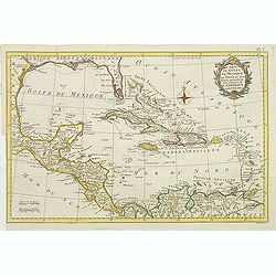
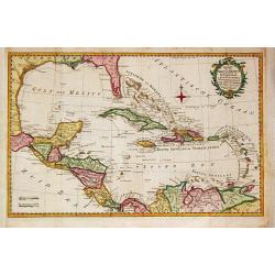
Carte du Golfe du Mexique des isles et des pays adjacens . . .
Detailed map of Caribbean. The map was prepared by William Roberts (1721-1793) in 1777 for the English edition, in 1778 the first French edition followed, L'Histoire de L...
Date: Paris, Panckoucke, 1778
Selling price: ????
Please login to see price!
Sold in 2011
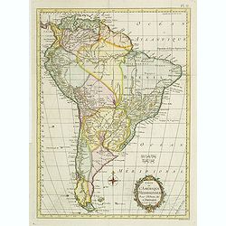
Carte de L\'Amerique Méridionale. . .
Detailed map of South America. The map was prepared by William Roberts (1721-1793) in 1777 for the English edition, in 1778 the first French edition followed, L'Histoire ...
Date: Paris, Panckoucke, 1778
Selling price: ????
Please login to see price!
Sold in 2011
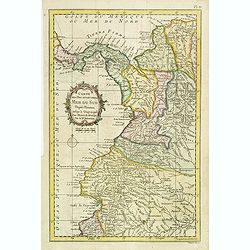
Carte des Pays situés sur la Mer du Sud. . .
Detailed map of Panama, Colombia and Ecuador. The map was prepared by William Roberts (1721-1793) in 1777 for the English edition, in 1778 the first French edition follow...
Date: Paris, Panckoucke, 1778
Selling price: ????
Please login to see price!
Sold in 2011
Le Cercle de Baviere...
Attractive copper-engraved map of lower Bavaria. Extends to show parts of Austria and the Czech Republic. Shows the area between Pilsen, Linz, Bayreuth, Ingolstadt, Salzb...
Date: Venice, 1778
Selling price: ????
Please login to see price!
Sold in 2011

Representation du feu terrible à nouvelle york.
So-called optical print of New York, showing several buildings along street engulfed in flames during fire on September 19, 1776, citizens being beaten by Redcoats, and l...
Date: Augsburg, 1778
Selling price: ????
Please login to see price!
Sold in 2011

L\'entrée triumphale de troupes royales à Nouvelle York
So-called optical print of New York. Although Washington’s troops successfully retreated to Manhattan after their defeat at the Battle of Long Island, their position wa...
Date: Augsburg, 1778
Selling price: ????
Please login to see price!
Sold in 2011
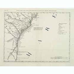
Parte Orientale della Florida, della Giorgia, e Carolina Meridionale.
Attractive map covering the coast from S.Augustine till Long Bay, including Jacksonville, Savannah. From Zatta's Atlante Novissimo.
Date: Venice, 1778
Selling price: ????
Please login to see price!
Sold in 2011
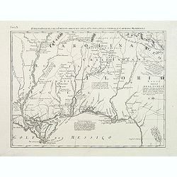
Luigiana Inglese, colla Parte Occidentale della Florida, della Giorgia, e Carolina Meridonale.
Showing the area bounded by the Mississippi River, Gulf Coast and the Southern Appalachians. The map is based on the Mitchell' map and was published in Antonio Zatta's fo...
Date: Venice, 1778
Selling price: ????
Please login to see price!
Sold in 2011
CARTE DU CANADA ET DES ETATS-UNIS de l'Amérique Septentrionale Par le S.r ROBERT DE VAUGONDY Geog. Ord.du Roi. . .
A separate issue. This is an updated version of map 1753.2 and one of the first maps to name the United States (Etats-Unis) in the title. Covers Canada east of Lake Super...
Date: Paris, 1778
Selling price: ????
Please login to see price!
Sold in 2012
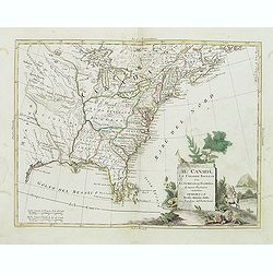
Il Canada Le Colonie Inglesi Con La Luigiana E Florida di nuouva Projezione...1778.
Map of East coast of America including the Great Lakes. The map makes mention of the upper and lower English Colonies in Louisiana. Ohio here called "Ohio ou alta Lu...
Date: Venise, 1778
Selling price: ????
Please login to see price!
Sold in 2015
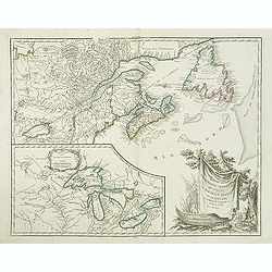
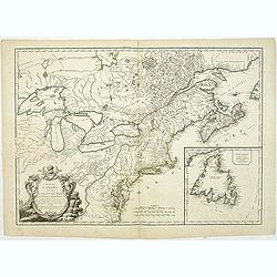
Partie de l'Amerique septent? Qui comprend la nouvelle France. . .
A fine copy of this map of New Foundland, Nova Scotia and the course of the St.Lawrence to Lake Ontario in a forth state.An inset shows Bellini's famous and important map...
Date: Paris, 1755-1778
Selling price: ????
Please login to see price!
Sold in 2019
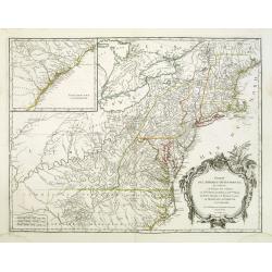
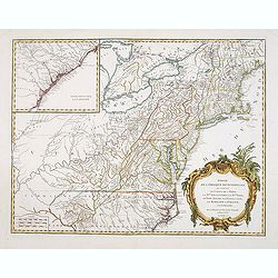
Partie De L'Amerique Septentrionale... Le Cours De L'Ohio, La N.lle Angleterre, a Nlle York, le New Jersey , La Pensyvanie, Le Maryland, Le Virginie, La Carolina...1755
From the Atlas Universel, a detailed map extending the length of the east coast from Penobscot Bay to Cape Fear and, in an inset, from Cape Fear to Fort St.Georges.This s...
Date: Paris, 1755 -1778
Selling price: ????
Please login to see price!
Sold
Carte de la Virginie et du Maryland. .
A third state (of 5), with Groux added to the cartouche. The late eighteenth century mapping of Virginia was dominated by Joshua Fry and Peter Jefferson's "A Map of ...
Date: Paris, 1755 - 1778
Selling price: ????
Please login to see price!
Sold in 2011
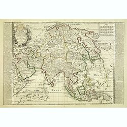
L'asie divisé suivant l'étendue des Empires et Royaumes qui la partagent et des Dominations établies par les . . .
French map describing Asia with fine cartouche title at bottom left. Surrounded by captions describing the historical and geographical contexts.The map is of interest for...
Date: Paris, 1778
Selling price: ????
Please login to see price!
Sold in 2012
Le Cercle de Baviere.
Fine copper engraved map of Baveria and Austria featuring Salzburg, Passau, Ingollstat & Regensberg. It is from the Italian edition of Vaugondy's map from "Atlas...
Date: Venice, 1778
Selling price: ????
Please login to see price!
Sold in 2015

L'entrée triumphale de troupes royales à Nouvelle York.
So-called optical print of New York. Although Washington’s troops successfully retreated to Manhattan after their defeat at the Battle of Long Island, their position wa...
Date: Augsburg, 1778
Selling price: ????
Please login to see price!
Sold in 2012

Histoire Naturelle.Vers Testaces a Coquille Multivalve...
Complicated engraving depicting Barnacles.
Date: Paris, 1778
Selling price: ????
Please login to see price!
Sold in 2013
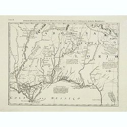
Luigiana Inglese, colla Parte Occidentale della Florida, della Giorgia, e Carolina Meridonale.
Showing the area bounded by the Mississippi River, Gulf Coast and the Southern Appalachians. The map is based on the Mitchell' map and was published in Antonio Zatta's fo...
Date: Venice, 1778
Selling price: ????
Please login to see price!
Sold in 2014

Vue de Peckin. (Peking)
So-called optical print of Peking published by "Collection des prospects" and engraved by G. B. Leizelt. Title is engraved mirror-imaged along the top. Lower ti...
Date: Augsburg, 1778
Selling price: ????
Please login to see price!
Sold in 2012
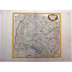
Duche de Savoye qui comprend le Chablais, le Fossigny, Le Genevois...
Fine map of the area, extending from Lake Geneva southwards, including Aosta, Aix-les-Bains, Chambéry, Annecy, Chamonix, etc. Very nice depiction of the mountains and va...
Date: Venice, 1778
Selling price: ????
Please login to see price!
Sold in 2012

Nouvel atlas geographique & historique.. / Nieuwe en geographische en historische Atlas . . .
This second edition of this charming travel compendium is becoming relatively scarce nowadays.Illustrated with a charming frontispiece, two uncolored plates of a sphere, ...
Date: Amsterdam, 1778
Selling price: ????
Please login to see price!
Sold in 2013
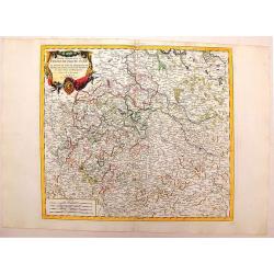
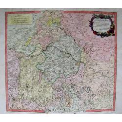
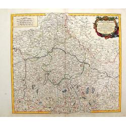
Partie Meridionale du Cercle de Haute Saxe.
Hand Colored map of Upper Saxony in Germany around the city of Leipzig. Also, parts of Czechoslovakia. With a fine decorative title cartouche. From the Italian edition of...
Date: Venice, 1778
Selling price: ????
Please login to see price!
Sold in 2014
Cercle de Souabe.
Large, highly detailed map of Swabia, Germany, flanked with western Austria and part of Switzerland. From the Italian edition of Vaugondy's map. Decorated with fine Rococ...
Date: Venice, 1778
Selling price: ????
Please login to see price!
Sold in 2016
Partie de l'Amerique septentrionale.. le cours de L'Ohio. . .
From the Atlas Universel, a detailed map extending the length of the east coast from Penobscot Bay to Cape Fear and, in an inset, from Cape Fear to Fort St.Georges.This i...
Date: Paris, 1755 -1778
Selling price: ????
Please login to see price!
Sold in 2013
Carte de la Virginie et du Maryland. . .
The late eighteenth century mapping of Virginia was dominated by Joshua Fry and Peter Jefferson's A Map of the Inhabited part of Virginia containing the whole Province of...
Date: Paris, 1755 -1778
Selling price: ????
Please login to see price!
Sold in 2013
Partie de l\'Amerique septent? Qui comprend la nouvelle France. . .
A fine copy of this map of New Foundland, Nova Scotia and the course of the St.Lawrence to Lake Ontario in a fourth state.An inset shows Bellini's famous and important ma...
Date: Paris, 1755-1778
Selling price: ????
Please login to see price!
Sold in 2013
Partie de l'Amerique septentrionale.. le cours de L'Ohio. . .
From the Atlas Universel, a detailed map extending the length of the east coast from Penobscot Bay to Cape Fear and, in an inset, from Cape Fear to Fort St.Georges.This i...
Date: Paris, 1755 -1778
Selling price: ????
Please login to see price!
Sold in 2013
La Nuova Zelanda tracorsa nel 1769 e 1770 dal Cook commandante dell' Endeavour Vascello di S.M.Britannica.
Antonio Zatta’s map of New Zealand is not only one of the first to show the results of Cook’s voyages, but is also one of the most attractive of the islands. Consider...
Date: Venise, 1778
Selling price: ????
Please login to see price!
Sold in 2013

Der Einzug der Königlichen Völcker in Neu York. - l'Entré triumphale de troupes Royales a Nouvelle York.
A so-called optical print showing the triumphal entry of the British troops marching in triumph through the streets of New York. Engraved by F.X. Habermann (1721-1796).In...
Date: Augsburg, 1778
Selling price: ????
Please login to see price!
Sold

Debarquement des troupes engloises a nouvelle York.
A so-called optical print showing a fanciful view of British troops disembarking at New York City. Built environment includes churches, dwellings, ships, and boats. Engra...
Date: Augsburg, 1778
Selling price: ????
Please login to see price!
Sold

La destruction de la Statue royale a Nouvelle York.
So-called optical print, engraved by F.X. Habermann (1721-1796). Revolutionary War print, depicting the Sons of Liberty tearing down a statue of King Georg III at Bowling...
Date: Augsburg, 1778
Selling price: ????
Please login to see price!
Sold in 2015