Browse Listings
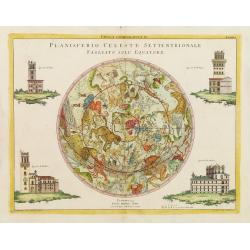
Planisferio Celeste Settentrionale tagliato sull Equatore.
Celestial chart, showing the observatories in Paris, Kassel, Greenwich, Copenhagen. The southern skies. Engraved by G.Zuliani after G. Pitteri.The chart has in lower part...
Date: Venice 1777
Selling price: ????
Please login to see price!
Sold
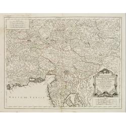
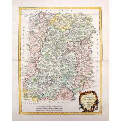
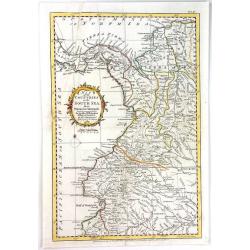
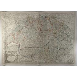
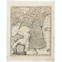
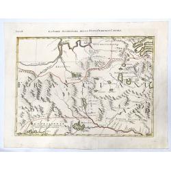
Partie Meridionale du cercle D'Autriche. . .
Uncommon, finely and crisply engraved map with large decorative title cartouche.Very detailed sheet that is centered roughly on Trieste and extends in to the mouth of the...
Date: Venice 1777
Selling price: ????
Please login to see price!
Sold in 2017
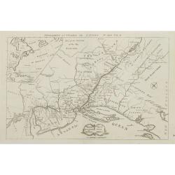
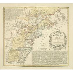
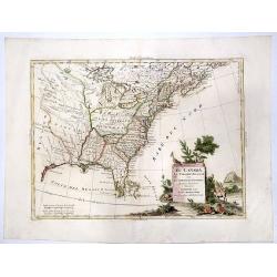
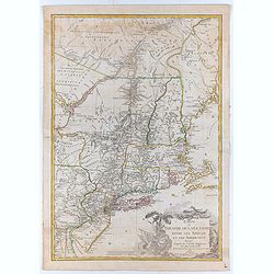
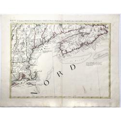
Theatre de la guerre en Amerique. Seat of war in America.
RARE. This map of uncertain date and origin is oriented with northeast at the top, with a banner Supplement au Courier de L\'Europe No. XXXII Vol. II, apparently a French...
Date: London, 1777
Selling price: ????
Please login to see price!
Sold in 2009
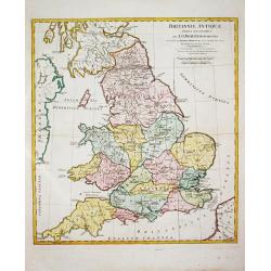
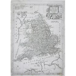
Brittanniae Antiquae Tabula Geographica.
John Horsley's map of antique England, published in ' A Complete Body of Ancient Geography'.
Date: London, R. Sayer and J. Bennett, 1777
Selling price: ????
Please login to see price!
Sold in 2011
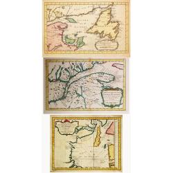
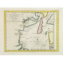
Carte des Parties du Nord-Ouest de l' Amerique./Carte des Parties du Nord-Ouest de l' Amerique. / Carte du Golphe de St. Laurent et Pays Voisins. / 3 maps by Bellin
Jacques Nicolas Bellin (1702-720) was the most important French hydrographer of the 18th century. Sea-atlas 'Hydrographique Français' , 1756-65, atlas to accompany Prév...
Date: Amsterdam, 1777
Selling price: ????
Please login to see price!
Sold in 2021
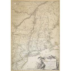
Carte du Theatre de la Guerre Entre les Anglais et les Americains...
This is an important separately published French map of the northern American colonies at the beginning of the American Revolution.Here in a proof- state !, later issued ...
Date: Paris, Esnauts et Rapilly, 1777
Selling price: ????
Please login to see price!
Sold in 2011
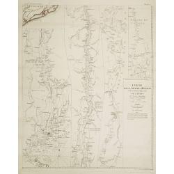
Cours de la rivière d'Hudson avec la communication avec le Canada par le Lac Champlain jusqu'au Fort Chambly par Sauthier a 4 Mmiles pour pouce anglois.
Le Rouge's version of this important large-scale map of Claude Sauthier's map of the course of the Hudson River. The map was the inset map of a 4 sheet map entitled "...
Date: Paris, 1777
Selling price: ????
Please login to see price!
Sold in 2008
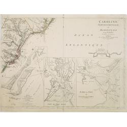
Caroline Septentrionalr et Meridionale en 4 Feuilles . . .
Le Rouge\'s version of this important large scale map of North Carolina. One sheet of four from a very rare wall map. The lower right sheet only; showing the coastline ar...
Date: Paris, 1777
Selling price: ????
Please login to see price!
Sold in 2008
![[Page from \"Caroline Septentrionalr et Meridionale en 4 Feuilles . . .\"]](/uploads/cache/26346-250x250.jpg)
[Page from \"Caroline Septentrionalr et Meridionale en 4 Feuilles . . .\"]
One sheet of four from the Le Rouge\'s version of this important large scale map of North Carolina. The lower left sheet showing the coastline south of Charlestown and la...
Date: Paris, 1777
Selling price: ????
Please login to see price!
Sold in 2008
![[Page from \"Caroline Septentrionalr et Meridionale en 4 Feuilles . . .\"]](/uploads/cache/26347-250x250.jpg)
[Page from \"Caroline Septentrionalr et Meridionale en 4 Feuilles . . .\"]
One sheet of four from the Le Rouge\'s version of this important large scale map of North Carolina. The upper right sheet showing the coastline of Corolina with Pamticoe ...
Date: Paris, 1777
Selling price: ????
Please login to see price!
Sold in 2008
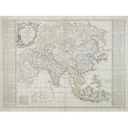
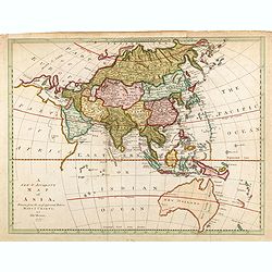
L'ASIE Divisée en ses Grandes Régions et Empires Subdivisée en ses Principaux Etats. . .
Originally prepared by J.B. Nolin, and re-issued by Basset. A general map of Asia with two French text columns on either side of the map describing the different regions ...
Date: Paris, 1777
Selling price: ????
Please login to see price!
Sold in 2009
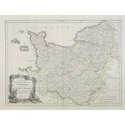
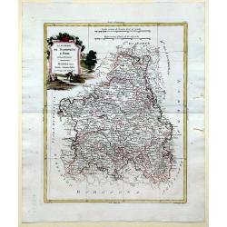
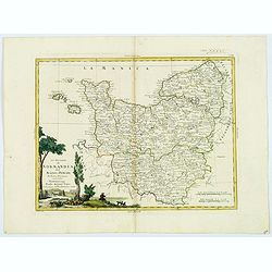
Carte du Gouvernement de Normandie avec celui du Maine et Perche projettée et assujettie aux observat. À Paris par M. Bonne Mtre Mathémat. À Paris 1771.
A general map of Normandy, Maine and Perche describing these different regions. Published by P. Santini map, an Italian map publisher who worked in Venice. Notable works...
Date: Venice, 1777
Selling price: ????
Please login to see price!
Sold
Carte Des Parties Du Nord-Ouest De L'Amerique Suivant les Voyages de Middleton et d Ellis en 1742 et 1746..
Uncommon Dutch edition of this attractive map prepared by J. N. Bellin. Map of the Hudson Bay area. Bellin was quite confused about the settlements (York Factory, Port Ne...
Date: Amsterdam, 1777
Selling price: ????
Please login to see price!
Sold in 2023
America Septentrionalis a Domino d'Anville. . .
The map is thoroughly annotated in German. Interesting map of the Colonies at the outset of the French & Indian War. Some of the interesting features include a trunca...
Date: Nuremberg, 1777
Selling price: ????
Please login to see price!
Sold in 2016
![Planisferio Celeste Meridionale tagliato sull Equatore. [together with] Planisferio Celeste Settentrionale tagliato sull Equatore.](/uploads/cache/28674-250x250.jpg)
Planisferio Celeste Meridionale tagliato sull Equatore. [together with] Planisferio Celeste Settentrionale tagliato sull Equatore.
Pair of attractive engravings of celestial planispheres with the constellations shown in their allegorical guises.Celestial chart, showing the observatories in Paris, Kas...
Date: Venice, 1777
Selling price: ????
Please login to see price!
Sold in 2013
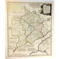
Li Governi Di Sciampagna E Brie Di Nuiva Projezione
This map of France highlights the Champagne and Brie regions in the northeastern part of the country. Each of these cities derives their names from the sparkling wine and...
Date: Venice, 1777
Selling price: ????
Please login to see price!
Sold in 2010
A New and Accurate Map of England. . .
A finely detailed, small scale map of England by Thomas Bowen. Emmanuel Bowen was one of the leading English mapmakers of the eighteenth-century, and was cartographer to ...
Date: London, c.1777
Selling price: ????
Please login to see price!
Sold in 2010

A View of Schorskarskoi Pagost' and 'A View if Trojesski'.
Fine, hand-colored, copperplate engraving featuring two topographical scenes of Siberia - "view of Schorskarskoi Pagost" & "A view of Trojesski on the ...
Date: London, 1777
Selling price: ????
Please login to see price!
Sold in 2013
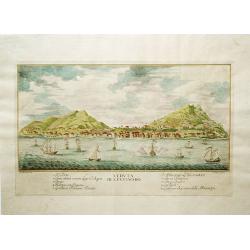
Veduta di S. Eustachio
This is a rare view of St. Eustatius (Statia) in the Dutch West Indies, which had the distinction of being the first foreign nation to officially recognize the newly form...
Date: Italy, 1777
Selling price: ????
Please login to see price!
Sold in 2012
Caroline
Le Rouge's version of this important large-scale map of Claude Sauthier's map of the course of the Hudson River. The map was the inset map of a 4 sheet map entitled "...
Date: Paris, 1777
Selling price: ????
Please login to see price!
Sold in 2012
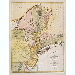
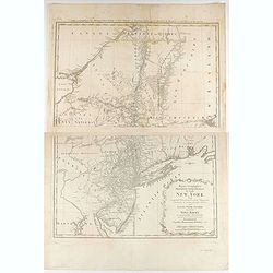
A Map of the Provinces of New-York and New-Jersey, with a Part of Pennsylvania and the Province of Quebec. from the Topographical Observations of C.J. Sauthier.
This map afforded British commanders during the Revolutionary-War an excellent overview of areas that would be crucial in the early years of the war, in particular the Hu...
Date: Augsburg, 1777
Selling price: ????
Please login to see price!
Sold in 2013
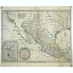
A new map of Mexico or New Spain in which the Motions of Cortes may be traced. . .
Map shows provinces of New Spain, [Baja] California, "New Albion." New Mexico and Louisiana are shown separated by "Great Space of Land unknown." Area...
Date: London, Strahan, T.Cadell, ca. 1777
Selling price: ????
Please login to see price!
Sold in 2013
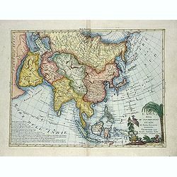
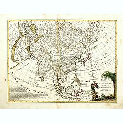
L'Asia divisa ne' suoi principali stati di nuova projezione.
Map showing Asia, with a decorative title cartouche. The map is of interest for the use of East Sea, the sea between Korea and Japan, here called "Mare di Corea"...
Date: Venise, 1777
Selling price: ????
Please login to see price!
Sold in 2013
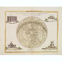
Planisferio Celeste Meridionale tagliato sull Equatore.
Celestial chart, showing the observatories in Paris, Kassel, Greenwich, Copenhagen. The southern skies. Engraved by G.Zuliani after G. Pitteri. A beautiful celestial char...
Date: Venice, 1777
Selling price: ????
Please login to see price!
Sold in 2013
Carte dy Gouvernement de L'Isle de France et de L'Orleanois
A large, beautiful map of France's most populous province, centered around Paris. It is decorated by a large title cartouche. Francois [Francesco] Santini was a Venetian...
Date: Venice, 1777
Selling price: ????
Please login to see price!
Sold in 2014
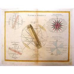
Tavola Sferica.
Depicting chart with three spheres showing the rotation of the earth and its relation to the zodiac. With very large comass rose showing the direction of Mediterranean wi...
Date: Venice, 1777
Selling price: ????
Please login to see price!
Sold in 2016
Carte des Gouvernements D'Anjou et du Saumurois.
A beautiful example of Rigobert Bonne's decorative map of the famous French "Chateau" wine-making region, hugging the Loire Valley. It was included in Santini's...
Date: Venice, 1777
Selling price: ????
Please login to see price!
Sold in 2015
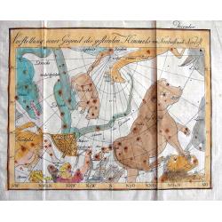
Vorstellung einer Gegend des gestirnten Himmels vom Nordwest nach Nordost.
An unusual engraved celestial chart of the constellations of the Northern skies. Includes Ursa Major (Great Bear), Leo, Lynx, Dragon, Camel, Hercules, etc. Shows the Nort...
Date: Germany, c1777
Selling price: ????
Please login to see price!
Sold in 2013
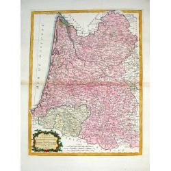
Carte du Gouvernement de Guienne et Gascogne avec Celui de Bearn et Basse Navarre.
Striking Venetian edition of a copper engraved map of Guyenne and Gascogne in southwestern France, the home of Armagnac and Foie Gras. Bonne created the map. Francois or ...
Date: Vienna, 1777
Selling price: ????
Please login to see price!
Sold in 2014
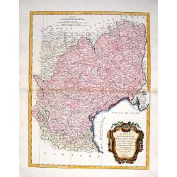
Carte des Gouvernements de Languedoc, de Foix et de Roussillon.
Striking large copper engraved map of the governments of Languedoc, Roussiloon de Foix and eastern Guienne. Lovely colorful floral title cartouche. Francois or Paolo Sa...
Date: Vienna, 1777
Selling price: ????
Please login to see price!
Sold in 2013
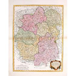
Carte des Gouvernements du Berri, du Nivernois, de la Marche, du Bourbonnois, du Limosin et de L'Auvergne.
Striking large map of central France including Limoges, Moulins. It was based on a smaller map by R. Bonne in 1771. It features a Rococco cartouche. Francois or Paolo San...
Date: Venice, 1777
Selling price: ????
Please login to see price!
Sold in 2016
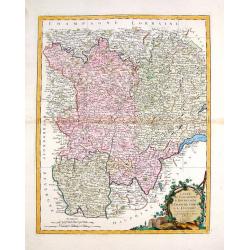
Carte des Gouvernements de Bourgogne, de Franche Comte et de Lyonnois.
Impressive large map of French provinces, including Lyon, Dijon, and Besancon, and the border with Switzerland. It was based on a smaller map by Bonne in 1771. It feature...
Date: Venice, 1777
Selling price: ????
Please login to see price!
Sold in 2014
A new & accurate map of Asia, ...
The map is of interest for the use of Sea of Korea, for the sea between Korea and Japan.Map of Asia, with coastlines fairly accurately drawn but the coasts of Australasia...
Date: London, 1777
Selling price: ????
Please login to see price!
Sold in 2015
L'Asia divisa ne' suoi principali stati di nuova projezione.
Map showing Asia, with a decorative title cartouche. The map is of interest for the use of Mare di Corea for the sea between Korea and Japan.
Date: Venise, 1777
Selling price: ????
Please login to see price!
Sold in 2014
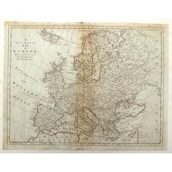
A New & Accurate Map of Europe, Drawn from the best Authorities.
Detailed map of Europe engraved by Thomas Bowen for "BANKES'S NEW SYSTEM OF GEOGRAPHY" in LONDON IN 1777. Iceland is oversized.
Date: London, 1777
Selling price: ????
Please login to see price!
Sold in 2017
Map of the Countries of the South Sea from Panama to Guayquil
A copperplate engraved map, published for the Rev. Dr. Robertson's History of America. By Thomas Kitchin, Senior, Hydographer to his Majesty.The map comprises the area no...
Date: London, 1777
Selling price: ????
Please login to see price!
Sold in 2017
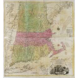
A map of the most inhabited part of New England, containing the provinces of Massachusetts Bay and New Hampshire, with the colonies of Konektikut and . . .
A separately published copper engraving in four sheets, 96.5 x 100cm. This is the second plate by Probst after the Jefferys-Green map.With an imposing title, cartouche up...
Date: Augsburg, 1777
Selling price: ????
Please login to see price!
Sold in 2016
Chart of Discoveries made in the South Pacific Ocean...
An interesting copper-engraved sea-chart of Captain Cook's exploration of New Caledonia and the islands of Vanuatu in 1774. Tracks the route of the ship Resolution betwee...
Date: London, 1777
Selling price: ????
Please login to see price!
Sold in 2016
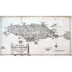
Die Insel Sanct Thomas mit den mehresten Plantagen 1767.
A rare and sought after map of the Island of St. Thomas, US Virgin Islands. Although dated 1767 it was published in 1777 in Oldendorp's "Geschichte der Mission der e...
Date: Nuremberg, 1777
Selling price: ????
Please login to see price!
Sold in 2018
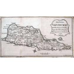
Die Insel Sainte Croix mit den Namen der Plantagen die bestaendig sind.
Very rare and sought after map of the Island of St. Croix (Santa Cruz), one of the US Virgin Islands. Although dated 1767 this it was published in 1777 in Oldendorp's &qu...
Date: Nuremberg, 1777
Selling price: ????
Please login to see price!
Sold in 2022
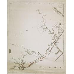
A Chart of New York Island & North River: East River, Passage Through Hell's Gate, Flushing Bay, Hampstead Bay ...... (Fragment Only)
This is a fragment of a very important, large chart. It was produced by Joseph Des Barres in London in 1777. The full map shows Long Island north shore from Eaton’s N...
Date: London, 1777
Selling price: ????
Please login to see price!
Sold in 2017
An Accurate Map of the County of Monmouth, Divided Into Hundreds
This attractive map of the county of Monmouth identifies major roads, villages, churches, and castles, it is by Emanuel Bowen, and was published for Robert Sayer in Londo...
Date: London, 1777
Selling price: ????
Please login to see price!
Sold in 2017
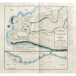
Plano de la Plaza de la Colonia del Sacramento...
A highly rare map of Colonia del Sacramento in Uruguay, at the Rio de la Plata, facing Buenos Aires.The plan includes an A-X legend of places, churches, batteries and oth...
Date: Madrid, 1777
Selling price: ????
Please login to see price!
Sold
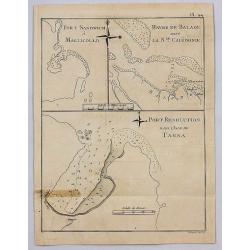
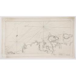
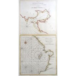
Port Sandwich in Mallicollo. Harbour of Balade in New Caledonia, Port Resolution in the Isle of Tanna.
A series of three harbour plans on one sheet. It is Plate No. 44 from "A Voyage Towards the South Pole" by Captain James Cook. It was published in 1777 by Wm. S...
Date: London, 1777
Selling price: ????
Please login to see price!
Sold in 2017

Plan de la Baye Dusky (Obscure) a la Nouvelle Zelande, 1773.
A map engraved by Benard with an inset of Pickersgill harbour. From the French edition of Cook’s Voyages, published in Paris in 1777 (only one year after the English ed...
Date: Paris, 1777
Selling price: ????
Please login to see price!
Sold in 2023
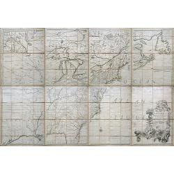
Amerique septentrionale avec les Routes, Distances en miles, Villages et Etablissements François et Anglois. Par le Docteur Mitchel Traduit de l'Anglois ... Corigee en 1776 par M. Hawkins..
An engraved map in outline color. On eight sheets, each measuring approx. 68 x 46 cm (26¾ x 19¼"), if joined, would form a single large sheet 59 x 79 inches. Backe...
Date: Paris, 1756 /1777
Selling price: ????
Please login to see price!
Sold in 2019
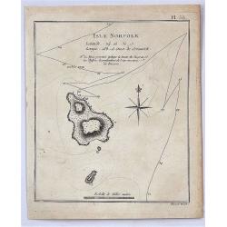
Isle Norfolk.
A fine map of Norfolk Island from James Cook's 2nd voyage. With note: "The pricked line shews the ship's track & the figures the depth of water in fathoms"....
Date: London, 1777
Selling price: ????
Please login to see price!
Sold in 2017
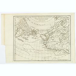
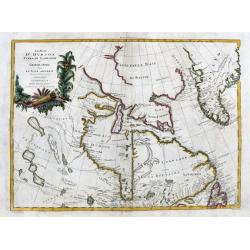
Nouveau Systeme Geographique par lequel on concilie les anciennes connoissances sur les Pays Nord-Ouest de l'Amerique avec les nouvelles decouvertes des Russes au Nord de la Mer du Sud.
An extremely rare and virtually unknown Dutch edition of De Vaugondy's map, published in Amsterdam by Krevelt in 1777. De Vaugondy's Final Chapter In The Greatest Cartogr...
Date: Amsterdam, 1777
Selling price: ????
Please login to see price!
Sold in 2018
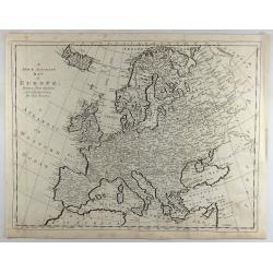
A New & Accurate Map of Europe, Drawn from the Best Authorities.
A fine engraved map including all of Europe, Iceland, the Mediterranean, and the Barbary Coast, by Thomas Bowen in England in 1777. From “A New & Accurate Map of E...
Date: London, 1777
Selling price: ????
Please login to see price!
Sold in 2018
Carte de la Republique des Suisses.
A fine detailed map of Switzerland featuring the cantons. The map was engraved by J.E.. Hauman in Paris in 1777, and was published by Chez Mondhare. The map features a de...
Date: Paris, 1777
Selling price: ????
Please login to see price!
Sold in 2019
A Map of Philadelphia and Parts Adjacent.
A nice example of the 1777 Revolutionary War edition of the Scull & Heap map of Philadelphia, published by the Gentleman's Magazine. The Scull & Heap map went thr...
Date: London, 1777
Selling price: ????
Please login to see price!
Sold in 2019
Li Governi di Normandia del Maine e Perche. . .
An attractive map that encompasses all of Normandie with the semi-autonomous English Channel Islands islands of Alderney, Jersey & Guernsey, Maine in the French provi...
Date: Venice, 1777
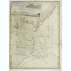
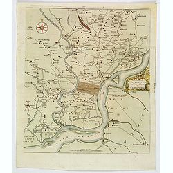
The Harbour of Charles Town in South-Carolina from the Surveys of Sr. Jas. Wallace Captn. in his Majesty Navy & Others, with A View of the Town from the South Shore of Ashley River.
A chart of Charles Town's Harbour in South Carolina, with in upper left part a view of Charles Town (present-day Charleston), South Carolina, from the north-eastern shore...
Date: London, 1777
Selling price: ????
Please login to see price!
Sold in 2019
![[ Ttitle page of volume II ] Atlantic Neptune published for the use of the Royal Navy of Great Britain . . .](/uploads/cache/44833-250x250.jpg)
[ Ttitle page of volume II ] Atlantic Neptune published for the use of the Royal Navy of Great Britain . . .
Title page, taken from the second volume of "Atlantic Neptune".The Atlantic Neptune is universally recognised as one of the most magnificent atlases ever made.E...
Date: London, 1777
Selling price: ????
Please login to see price!
Sold in 2019
A map of Quang-Tong or Lea-Tonge Province..
Detailed and decorative map of Korea in lower left corner a charming title cartouche. To the right "Sea of Korea".
Date: London, 1777
Selling price: ????
Please login to see price!
Sold in 2020

Li Governi di Normandia del Maine e Perche.
A pleasant map shows all of Normandie with its islands: Maine in the french province of Pays de la Loire and Berche in the region of Bourgogne-Franche-Comté. Features a...
Date: Venice, 1777
Selling price: ????
Please login to see price!
Sold in 2023
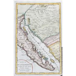
Carte De La Californie...
Map of Baja California, parts of Mexico, and Arizona. Very detailed with settlements, mountains, islands, missions, Indian tribes (Apache, Pericu, Yuma and Cochimi). Thi...
Date: Amsterdam, 1777
Selling price: ????
Please login to see price!
Sold in 2020
![Carte nouvelle de l'Amérique angloise contenant tout ce que les Anglois possèdent […] avec la Floride / gravée[…] par Maththias Albert Lotter. . .](/uploads/cache/47847-250x250.jpg)
Carte nouvelle de l'Amérique angloise contenant tout ce que les Anglois possèdent […] avec la Floride / gravée[…] par Maththias Albert Lotter. . .
A large, beautiful and detailed map of the Eastern Seaboard, from Northern Florida St. Augustine) to Newfoundland, and the St. Lawrence Gulf, including numerous Indian tr...
Date: Augsburg, 1777
Selling price: ????
Please login to see price!
Sold in 2023
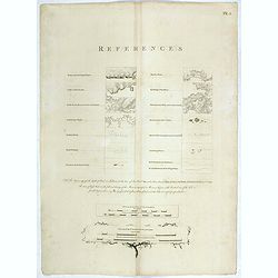
[ Key page
Copper engraved page showing the key references for using the charts in the "Atlantic Neptune". In lower part "Scale of the coasting charts, and Scale of t...
Date: London, 1778
Selling price: ????
Please login to see price!
Sold in 2019
![[ Text page : Nautical directions to sail into the Harbour of New-York, & c.]](/uploads/cache/44836-250x250.jpg)
[ Text page : Nautical directions to sail into the Harbour of New-York, & c.]
Text page "Nautical directions to sail into the Harbour of New-York, & c.", taken from the "Atlantic Neptune". This superb sea chart constructed f...
Date: London, 1778
Selling price: ????
Please login to see price!
Sold in 2019
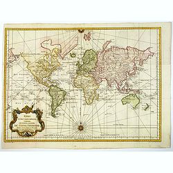
Essay d'une carte reduite contenant les parties connuees Du Globe Terrestre. . .
An attractive example of J. N. Bellin's 1778 nautical chart of the world. It presents the world on 'Mercator's Projection' and is based on a Paris meridian. North America...
Date: Paris, [1748] 1778
Selling price: ????
Please login to see price!
Sold in 2023
IL CANADA Le Colonie Inglesi Con La Luiglana e Florida. Di nuova Projezione.
A striking map of the United States and Canada, which includes references to the Upper and Lower English Colonies of Louisiana. One of the very few maps from the period w...
Date: Venice, 1778
Selling price: ????
Please login to see price!
Sold in 2020
![IL PAESE DE SELVAGGI OUTAGAMIANI, MASCOUTENSI, ILLINESI, E PARTE DELLE VI. NAZIONI. (Fogl. IV.)[Lake Michigan]](/uploads/cache/83526-250x250.jpg)
IL PAESE DE SELVAGGI OUTAGAMIANI, MASCOUTENSI, ILLINESI, E PARTE DELLE VI. NAZIONI. (Fogl. IV.)[Lake Michigan]
A striking and important regional map, bounded by the Missouri River, Lake Michigan and what would ultimately become Michigan in the north and extending south to include ...
Date: Venice, 1778
Selling price: ????
Please login to see price!
Sold in 2020
LA PARTE OCCIDENTALE DELLA NUOVA FRANCIA O CANADA (Fogl. II.)
A striking and detailed map of the region bounded by the Ottawa River and Hudson Bay, drawn from John Mitchell's seminal map. It shows Messesaguesi (Massachusetts) in sou...
Date: Venice, 1778
Selling price: ????
Please login to see price!
Sold in 2020
![IL PAESE DE SELVAGGI OUTAUACESI E KILISTINESI INTORNO AL LAGO SUPERIORE. (Fogl. I.)[LAKE SUPERIOR,FLORIDA&BAHAMAS]](/uploads/cache/83528-250x250.jpg)
IL PAESE DE SELVAGGI OUTAUACESI E KILISTINESI INTORNO AL LAGO SUPERIORE. (Fogl. I.)[LAKE SUPERIOR,FLORIDA&BAHAMAS]
A striking and detailed map of the region the Great Lakes and an inset showing Florida and Bahamas. This map is a part of the Italian edition of John Mitchell's map of th...
Date: Venice, 1778
Selling price: ????
Please login to see price!
Sold in 2020
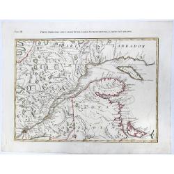
PARTE ORIENTALE DEL CANADA, NUOVA SCOZIA SETTENTRIONALE, E PARTE DI LABRADOR. (Fogl. III.)
A striking and detailed, important regional map, dissected diagonally by the St Lawrence and showing a portion of Southeastern Canada. This map is a part of the Italian e...
Date: Venice, 1778
Selling price: ????
Please login to see price!
Sold in 2020
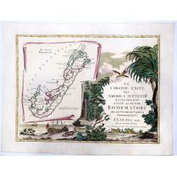
LE COLONIE UNITE dell' AMERICA SETTENTRle di nuova projezione assee li signori. . . (Title Page and Bermuda)
A striking, beautifull, title page of Zatta's twelve sheet monumental work, with inset showing the island of Bermuda. This map is a part of the Italian edition of John Mi...
Date: Venice, 1778
Selling price: ????
Please login to see price!
Sold in 2020
![LA PENSILVANIA, LA NUOVA YORK, IL JERSEY SETTENTRIO:le, CON LA PARTE OCCIDENTALE DEL CONNECTICUT. . . (Fogl. V.)[Lakes Huron, Erie, and Ontario]](/uploads/cache/83531-250x250.jpg)
LA PENSILVANIA, LA NUOVA YORK, IL JERSEY SETTENTRIO:le, CON LA PARTE OCCIDENTALE DEL CONNECTICUT. . . (Fogl. V.)[Lakes Huron, Erie, and Ontario]
A striking map of the north eastern section of the Italian edition of Mitchell's seminal map of North America, bounded by Lakes Huron & Oswego and Ohio in the west an...
Date: Venice, 1778
Selling price: ????
Please login to see price!
Sold in 2020
Carte du Théatre de la Guerre Entre les Anglais et les Américains: Dressée d'apres les Cartes Anglaises les plus modernes
Uncommon 1778 edition with the site of Burgoyne's surrender at Saratoga (here spelled "Saharatoga").This is an important separately published French map of the ...
Date: Paris, Esnauts et Rapilly, 1778
Selling price: ????
Please login to see price!
Sold in 2021
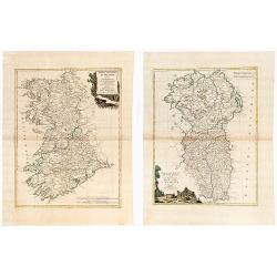
(IRELAND). Parte Del Regno D'Irlanda, cioe' Le Provincie D'Ulster, E Leinster. / Parte Del Regno D'Irlanda, cio+¿ Le Provincie Di Connaught, E Munster Di Nuova Projezione.
Together 2 sheets. Each image c. 31 x 41 cm. Original outline color, both with decorative colored title cartouches. Ireland shown on two double page maps. The first map s...
Date: Venice: Antonio Zatta. 1778
Selling price: ????
Please login to see price!
Sold in 2020
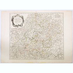
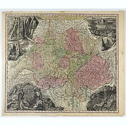
Cercle de Franconie qui comprend Les Eveches de Wurtzbourg. . .
A striking and highly detailed copper engraved map depicting a section of the German region of Franken (Franconia). The map gives several details concerning cities, villa...
Date: Venice, 1778
Selling price: ????
Please login to see price!
Sold in 2021
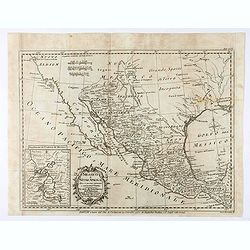
Messico o Nuova Spagna . . .
Map of Mexico Robertson’s "Storia d'America", printed in 1777. After a map of Thomas Kitchin.
Date: Florence, Gatti, 1778
Selling price: ????
Please login to see price!
Sold in 2021
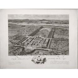
Plan perspective de l'École royale militaire.
A decorative bird's eye view of the complex of the French military school in Paris.
Date: Paris, 1778
Selling price: ????
Please login to see price!
Sold in 2022
Fogl. VI. L' Acadia Le Provincie di Sagadahook e Main La Nuova Hampshire La Rhode Island e Parte Di Massachusset e Connecticut.
The 6th sheet from an important twelve-sheet map, of the south east Canada and north east United States of America. The 12 map Antonio Zatta's version of John Mitchell'...
Date: Venice, 1778
Selling price: ????
Please login to see price!
Sold in 2020
Plan of Solsogon Harbour / Chart on the Eastern Coast of Bongo Bay (Mindanao).
A nice copper engraving, with 2 Philippine sea charts on one sheet, published by Laurie & Whittle in London; pl. 125. With the usual sand banks, depth soundings, rhum...
Date: London, 1794-1778
Selling price: ????
Please login to see price!
Sold in 2020
La Baja d' Hudson terra di Labrador e Groenlandia....
Great map of parts of Canada with Hudson Bay, Baffin Bay, Labrador, and Greenland. With many details such as Forts, settlements, bays, islands, indian regions, and unfini...
Date: Venice, 1778
Selling price: ????
Please login to see price!
Sold in 2020
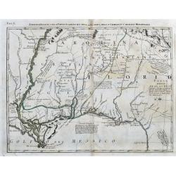
Luigiana Inglese, colla Parte Occidentale della Florida, della Giorgia, e Carolina Meridonale.
A very interesting Italian map based on John Mitchell's important map from 1755. It shows the Gulf Coast from Florida until the Mississippi Delta. It includes Biloxi, Pen...
Date: Venice, 1778
Selling price: ????
Please login to see price!
Sold in 2020
Mappa geographica Provinciæ Nova Eboraci ab Anglis New-York dictæ ex ampliori delineatione ad exactas dimensiones concinnata in arctius spatium redacta cura Claudii Josephi Sauthier ...
Mappa geographica Provinciæ Nova Eboraci ab Anglis New-York dictæ ex ampliori delineatione ad exactas dimensiones concinnata in arctius spatium redacta cura Claudii Jos...
Date: Nuremburg, 1778
Selling price: ????
Please login to see price!
Sold in 2020
Nova Totius Helvetiae cum suis subditis ac sociis tab. Geogr. . .
Detailed map of Switzerland divided up it its cantons. This one of the most decorative maps of Switzerland published in the eighteenth century, with many engraved place n...
Date: Augsburg, 1778
Selling price: ????
Please login to see price!
Sold in 2021

S. Rocco incarcerato Quadro ditutta Perfezione dipinto . . .
Rare etching depicting Saint Rocco imprisoned. Etched and aquatint by Vincenzio Vangelisti (Italian, Florence 1728–1798 Milan) after Guercino (Giovanni Francesco Barbie...
Date: Venice, 1778
Selling price: ????
Please login to see price!
Sold in 2023